Showing 12 items matching "local area development by europeans"
-
 Phillip Island and District Historical Society Inc.
Newspaper clippings
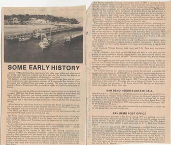
... ...local area development by europeans...Details from 1758 visit by Bass, Wattle Bark export in 1833, opening of surrounding district with pioneering families, Estate Agent, John Keam & Co and the installation of Postal services in 1873 (brief history of San Remo 1798 - 1928) local history documents newspapers san remo local area development by europeans newspapers san remo Titled San Remo Two clippings with sub-headings "some early history" - San Remo Heights Estate Hall and San Remo Post Office. ...Album donated by Miss Edith Elms via Chrisy Northcote. Details from 1758 visit by Bass, Wattle Bark export in 1833, opening of surrounding district with pioneering families, Estate Agent, John Keam & Co and the installation of Postal services in 1873 (brief history of San Remo 1798 - 1928)Two clippings with sub-headings "some early history" - San Remo Heights Estate Hall and San Remo Post Office. Photo of San Remo Port with fishing, boat middle, at top of article large sub-heading "San Remo"Titled San Remolocal history, documents, newspapers, san remo, local area development by europeans, newspapers san remo -
 Phillip Island and District Historical Society Inc.
Newspaper clippings, 1903
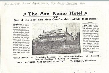
... ...local area development by europeans...Show the development of San Remo as a recreational area in 1903. local history documents newspapers san remo local area development by europeans black & white newspaper clipping advertisement newspapers san remo Photocopy of San Remo Hotel advertisement inserted by T Bergin - Proprietor - undated, listing activities - ocean beach, exquisite scenery, excellent fishing, bathing, golf, cycling, riding, driving. ...Donated by Miss Edith Elms via Chrisy Northcote. Show the development of San Remo as a recreational area in 1903.Photocopy of San Remo Hotel advertisement inserted by T Bergin - Proprietor - undated, listing activities - ocean beach, exquisite scenery, excellent fishing, bathing, golf, cycling, riding, driving. Photograph of San Remo Hotel top middle.local history, documents, newspapers, san remo, local area development by europeans, black & white newspaper clipping, advertisement, newspapers san remo -
 Phillip Island and District Historical Society Inc.
Newspaper clippings, approx 1909
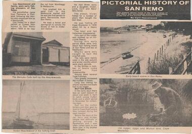
... ...local area development by europeans...Published in an unnamed newspaper local history documents newspapers san remo local area development by europeans black & white newspaper clipping newspapers- san remo hazelwood family history commercial activity Pictorial History of San Remo x Cyril Hazelwood Newspaper clipping entitled "Pictorial History of San Remo" by Cyril Hazelwood, detailing Lou Hazelwood pioneer fisherman and Mutton Bird catching - includes photographs of Manuka Cafe, Vivien Hazelwood's fishing boat, early beach scene at San Remo and collecting Mutton Birds at Cape Woolamai. ...Early commercial activities of the Hazelwood Family at San Remo approximately 1909. Published in an unnamed newspaperNewspaper clipping entitled "Pictorial History of San Remo" by Cyril Hazelwood, detailing Lou Hazelwood pioneer fisherman and Mutton Bird catching - includes photographs of Manuka Cafe, Vivien Hazelwood's fishing boat, early beach scene at San Remo and collecting Mutton Birds at Cape Woolamai.Pictorial History of San Remo x Cyril Hazelwoodlocal history, documents, newspapers, san remo, local area development by europeans, black & white newspaper clipping, newspapers- san remo, hazelwood family history, commercial activity -
 Phillip Island and District Historical Society Inc.
Newspaper clippings
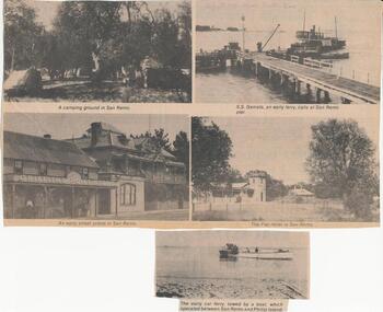
... ...local area development by europeans...development - approximately 1928 - 32. Hospitality and Fishing. local history documents newspapers san remo local area development by europeans fishing hospitality black & white newspaper clipping newspapers san remo commercial activity Five photographs of an early Car Ferry, a camping ground with tents and trees, SS Genista at Pier, an early street scene and the Pier Hotel San Remo Newspaper clippings ...Early scenes of San Remo commercial development - approximately 1928 - 32. Hospitality and Fishing.Five photographs of an early Car Ferry, a camping ground with tents and trees, SS Genista at Pier, an early street scene and the Pier Hotel San Remolocal history, documents, newspapers, san remo, local area development by europeans, fishing, hospitality, black & white newspaper clipping, newspapers san remo, commercial activity -
 Phillip Island and District Historical Society Inc.
Photograph, 1880's
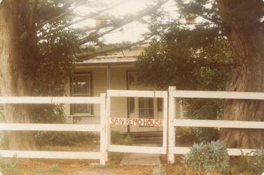
... ...local area development by europeans...Possibly Miss Elms' home. local history photography photographs slides film san remo local area development by europeans housing coloured photograph commercial development san remo dwellings San Remo house in red on gate Coloured photograph of front of house behind two Cypress Pines - post and rail fence across foreground. ...San Remo house built by Charles Grayden 1880? Possibly Miss Elms' home.Coloured photograph of front of house behind two Cypress Pines - post and rail fence across foreground.San Remo house in red on gatelocal history, photography, photographs, slides, film, san remo, local area development by europeans, housing, coloured photograph, commercial development san remo, dwellings -
 Phillip Island and District Historical Society Inc.
Photograph, 1880's
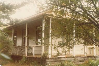
... ...local area development by europeans...Possibly Miss Elms' house. local history photography san remo local area development by europeans housing coloured photograph commercial development san remo domestic development coloured print - side view of weatherboard painted white/cream. ...San Remo house built by Charles Grayden 1880?? Possibly Miss Elms' house.coloured print - side view of weatherboard painted white/cream. Verandah with slender square posts - framed by Pine Tree on left and small leafed tree on right.local history, photography, san remo, local area development by europeans, housing, coloured photograph, commercial development san remo, domestic development -
 Mont De Lancey
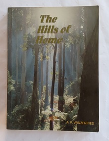
Book, Arthur Paul Wizenreid et al, The Hills of Home: A Bicentennial History of the Shire of Sherbrooke, 1988
... development from before European colonisation up to the bicentennial year. Sherbrooke Forest is a prominent 800+ hectare section of the Dandenong Ranges National Park, located about 40 km east of Melbourne. Famous for its towering Mountain Ash trees and dense fern gullies, it is a premier location for spotting wild lyrebirds, wallabies, and cockatoos. The forest offers popular hiking trails, including the walk to Sherbrooke Falls, and multiple picnic areas like Grants Picnic Ground. This is a local ...This 374-page work traces the history of the Shire of Sherbrooke in Victoria, Australia. It covers the region's development from before European colonisation up to the bicentennial year. Sherbrooke Forest is a prominent 800+ hectare section of the Dandenong Ranges National Park, located about 40 km east of Melbourne. Famous for its towering Mountain Ash trees and dense fern gullies, it is a premier location for spotting wild lyrebirds, wallabies, and cockatoos. The forest offers popular hiking trails, including the walk to Sherbrooke Falls, and multiple picnic areas like Grants Picnic Ground.This is a local history of the Shire of Sherbrooke in Victoria, Australia, documenting its development. The cover front has a beautiful green toned scene of the forest trees with the title printed at the top in pale green lettering outlined in black. The author is printed in yellow at the bottom. The title page lists the publishing details with Original pen and ink drawings by Jillienne Winzenried printed at the bottom. There is an Acknowledgements page, Foreword, Contents and Introduction. At the back, Chapter 18 is a Prologue, followed by three Appendices, Endnotes and an Index. Throughout the book are black and white photos as well as coloured ones, maps, illustrations, lists, advertisements. The back cover has a photograph with a black surround depicting a woman seated looking at autumn leaves. Pp. 374 non-fictionThis 374-page work traces the history of the Shire of Sherbrooke in Victoria, Australia. It covers the region's development from before European colonisation up to the bicentennial year. Sherbrooke Forest is a prominent 800+ hectare section of the Dandenong Ranges National Park, located about 40 km east of Melbourne. Famous for its towering Mountain Ash trees and dense fern gullies, it is a premier location for spotting wild lyrebirds, wallabies, and cockatoos. The forest offers popular hiking trails, including the walk to Sherbrooke Falls, and multiple picnic areas like Grants Picnic Ground. australian history, dandenong ranges - history, dandenong ranges - tourism and travel, tourism - victoria, sherbrooke forest - victoria -
 Box Hill Historical Society
Book, Doncaster-Templestowe Historical Society, Doncaster-Templestowe and Warrandyte since 1837
... local government within the area. The short history includes information on the pre-European occupation of the area, famous local identities, industry, residential development and social history....local government within the area. The short history includes information on the pre-European occupation of the area, famous local identities, industry, residential development and social history. ...A short history of the Cities of Doncaster, Templestowe and Warrandyte since 1837, including a section on the history of local government within the area. The short history includes information on the pre-European occupation of the area, famous local identities, industry, residential development and social history.doncaster, templestowe, warrandyte, local government, social history, gold, pioneers, hotels, schools, churches -
 Kew Historical Society Inc
Photograph - Flooding of the Yarra River in North Kew, 1934
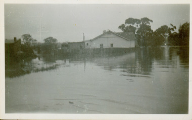
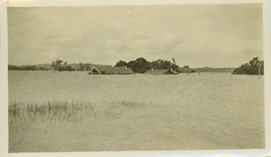
... Prior to urban development, the area since European settlement and the first land sales in the district in the 1840s, had been used for dairy farming. yarra river -- north kew floods -- yarra valley floods -- north kew floods -- 1934 natural disasters -- kew willsmere road Verso: HYATTS HOUSE / WILLSMERE ROAD / Stamped 3 163 Small sepia snapshot of floodwaters in North Kew. The point of view is of two houses belonging to local ...North Kew, now divided between Kew and Kew East, bordered the Yarra River. As such, it was a region subject to flooding in the Yarra Valley. Development beyond this point (ie Kellett Grove) was limited by the City of Kew's planning regulations. Prior to urban development, the area since European settlement and the first land sales in the district in the 1840s, had been used for dairy farming. Small sepia snapshot of floodwaters in North Kew. The point of view is of two houses belonging to local families that were surrounded by floodwater. Verso: HYATTS HOUSE / WILLSMERE ROAD / Stamped 3 163yarra river -- north kew, floods -- yarra valley, floods -- north kew, floods -- 1934, natural disasters -- kew, willsmere road -
 Kew Historical Society Inc
Photograph - Submerged houses in River Avenue, North Kew, 1934
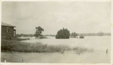
... development, the area since European settlement and the first land sales in the district in the 1840s, had been used for dairy farming. Vivid photograph contrasting domestic life and relationships with natural disasters such as the flood of 1934. yarra river -- north kew floods -- yarra valley floods -- north kew floods -- 1934 natural disasters -- kew Verso: COES & HYATTS ROOF / RIVER AVENUE / Stamped: 6414 Small sepia snapshot of two submerged houses belonging to local families in River Avenue, North Kew, during the 1934 floods. ...North Kew, now divided between Kew and Kew East, bordered the Yarra River. As such, it was a region subject to flooding in the Yarra Valley. Development beyond this point (ie Kellett Grove) was limited by the City of Kew's planning regulations. Prior to urban development, the area since European settlement and the first land sales in the district in the 1840s, had been used for dairy farming. Vivid photograph contrasting domestic life and relationships with natural disasters such as the flood of 1934.Small sepia snapshot of two submerged houses belonging to local families in River Avenue, North Kew, during the 1934 floods. The view is presumably from near Kellett Grove looking north towards Fairfield.Verso: COES & HYATTS ROOF / RIVER AVENUE / Stamped: 6414yarra river -- north kew, floods -- yarra valley, floods -- north kew, floods -- 1934, natural disasters -- kew -
 Kew Historical Society Inc
Photograph - Flooding of the Yarra River in North Kew, 1934
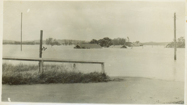
... Prior to urban development, the area since European settlement and the first land sales in the district in the 1840s, had been used for dairy farming. . yarra river -- north kew floods -- yarra valley floods -- north kew floods -- 1934 natural disasters -- kew Verso: THE SIDE OF RYANS Small sepia snapshot of a local family's house in what was then River Avenue, North Kew being surrounded by floodwaters. ...North Kew, now divided between Kew and Kew East, bordered the Yarra River. As such, it was a region subject to flooding in the Yarra Valley. Development beyond this point (ie Kellett Grove) was limited by the City of Kew's planning regulations. Prior to urban development, the area since European settlement and the first land sales in the district in the 1840s, had been used for dairy farming. .Small sepia snapshot of a local family's house in what was then River Avenue, North Kew being surrounded by floodwaters.Verso: THE SIDE OF RYANSyarra river -- north kew, floods -- yarra valley, floods -- north kew, floods -- 1934, natural disasters -- kew -
 Kew Historical Society Inc
Photograph - Flooding of the Yarra River in North Kew, 1934
... Prior to urban development, the area since European settlement and the first land sales in the district in the 1840s, had been used for dairy farming. . yarra river -- north kew floods -- yarra valley floods -- north kew floods -- 1934 natural disasters -- kew chipperfields boathouse Verso: THIS IS CHIPPERFIELD'S BOAT SHEDS & COES & WILLIAMS TAKEN FROM OUR STREET / 1934 Small sepia snapshot of the devastation caused by the 1934 flood.The photo was taken in the vicinity of Kellett Grove, North Kew and includes the roof of Chipperfield's Boathouse as well as other local houses. ...North Kew, now divided between Kew and Kew East, bordered the Yarra River. As such, it was a region subject to flooding in the Yarra Valley. Development beyond this point (ie Kellett Grove) was limited by the City of Kew's planning regulations. Prior to urban development, the area since European settlement and the first land sales in the district in the 1840s, had been used for dairy farming. .Small sepia snapshot of the devastation caused by the 1934 flood.The photo was taken in the vicinity of Kellett Grove, North Kew and includes the roof of Chipperfield's Boathouse as well as other local houses.Verso: THIS IS CHIPPERFIELD'S BOAT SHEDS & COES & WILLIAMS TAKEN FROM OUR STREET / 1934yarra river -- north kew, floods -- yarra valley, floods -- north kew, floods -- 1934, natural disasters -- kew, chipperfields boathouse