Showing 479 items matching "localities"
-
 Federation University Historical Collection
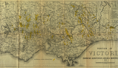
Photograph - coloured, Department of Lands and Survey, Portion of Victoria showing auriferous areas and mineral localities, 1935, 1935
... Portion of Victoria showing auriferous areas and mineral localities, 1935...Barker Library (top floor) Mount Helen goldfields Map included with book "Victoria: Gold and Minerals" issued by Mines Department Victoria, 1935 victoria auriferous areas mineral localities department of mines tin antimony copper silver lead tungsten manganese platinum iron Yellow mark indicating deposits Fold out coloured map Portion of Victoria showing auriferous areas and mineral localities, 1935 Photograph - coloured Department of Lands and Survey ...Map included with book "Victoria: Gold and Minerals" issued by Mines Department Victoria, 1935Fold out coloured mapYellow mark indicating depositsvictoria, auriferous areas, mineral localities, department of mines, tin, antimony, copper, silver lead, tungsten, manganese, platinum, iron -
 Victorian Railway History Library
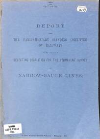
Booklet, Parliamentary Standing Committee of Victoria, Selecting Localities for the Permanent Survey of Narrow Gauge Lines, 1896
... Selecting Localities for the Permanent Survey of Narrow Gauge Lines...Selecting Localities for the Permanent Survey of Narrow Gauge Lines Booklet Parliamentary Standing Committee of Victoria ...The parliamentary standing committee on Railways on the question of selecting localities for the permanent survey of narrow gauge lines in Victoria in 1896.p.26.non-fictionThe parliamentary standing committee on Railways on the question of selecting localities for the permanent survey of narrow gauge lines in Victoria in 1896.railroad construction - victoria - history, vr narrow gauge railways - victoria - history -
 Stawell Historical Society Inc
Book - Inquest Files, Localities
... Localities...Black Binder Clear Plastic front cover, Black rear cover, plastic inserts with Typed paper. Localities Book Inquest Files ...Black Binder Clear Plastic front cover, Black rear cover, plastic inserts with Typed paper. -
 Bendigo Historical Society Inc.
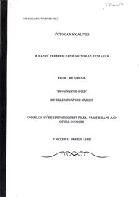
Book - STRAUCH COLLECTION - VICTORIAN LOCALITIES, A HANDY REFERENCE FOR VICTORIAN RESEARCH, FROM THE BOOK 'DIGGING FOR GOLD' BY HELEN DOXFORD HARRIS, 1988
... ...localities...Victorian Localities, a handy reference for Victorian research, from the book 'Digging for Gold' by Helen Doxford Harris, compiled by her from inquest files, parish maps and other sources....History House 11 Mackenzie Street Bendigo goldfields VICTORIA History localities Helen D Harris Victorian Localities, a handy reference for Victorian research, from the book 'Digging for Gold' by Helen Doxford Harris, compiled by her from inquest files, parish maps and other sources. ...Victorian Localities, a handy reference for Victorian research, from the book 'Digging for Gold' by Helen Doxford Harris, compiled by her from inquest files, parish maps and other sources.Helen D Harrisvictoria, history, localities -
Whitehorse Historical Society Inc.
Pamphlet, Campbell's Croft - Abbey Walk. Design Concept, c1988
... Localities are numbered but there is no key....A plan showing the design concept for Campbell's Croft and Abbey Walk reserves in Vermont. Localities are numbered but there is no key....A plan showing the design concept for Campbell's Croft and Abbey Walk reserves in Vermont. Localities are numbered but there is no key. Campbell's Croft - Abbey Walk. ...A plan showing the design concept for Campbell's Croft and Abbey Walk reserves in Vermont.A plan showing the design concept for Campbell's Croft and Abbey Walk reserves in Vermont. Localities are numbered but there is no key.A plan showing the design concept for Campbell's Croft and Abbey Walk reserves in Vermont.abbey walk, vermont, campbells croft -
 Greensborough Historical Society
Advertising Leaflet, Electric Station Estate; Watsonia; Saturday 16th October 1926, 16/10/1926
... This brochure contains a locality plan and drawing of the general store. ...One page B & W Photocopy (laminated) of auction brochure, with drawing of general store and locality plan...This brochure contains a locality plan and drawing of the general store. ...This is one of two brochures advertising the auction of the last 50 allotments of the Electric Station Estate, Watsonia, near the new railway station. This brochure contains a locality plan and drawing of the general store. (Refer 4526 for the other brochure for this auction) Auctioneer: Knight & Harwood.One page B & W Photocopy (laminated) of auction brochure, with drawing of general store and locality planwatsonia railway station, watsonia, electric station estate -
 Bendigo Historical Society Inc.
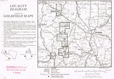
Document - JOAN O'SHEA COLLECTION: LOCALITY DIAGRAM AND NOTES FOR DUNNOLLY GOLDFIELD MAPS
... This locality diagram shows the areas covered by various goldfield maps. ...Joan O'Shea Collection. Locality diagram and notes for goldfield maps. ...This locality diagram shows the areas covered by various goldfield maps. ...This locality diagram shows the areas covered by various goldfield maps. The Berlin field encompassed Rheola and parts of the Moliagul and Kingower goldfields. The name 'Berlin' is a corruption of Byrr Lyn, birthplace of Alexander Clelland who made an important strike in 1868.Joan O'Shea Collection. Locality diagram and notes for goldfield maps. Dunolly map set. Wedderburn, Berlin, Dunolly, Maryborough, Avoca.mining, company exploration, dunolly map set., berlin, kingower, wedderburn, gold mining -
 The Beechworth Burke Museum
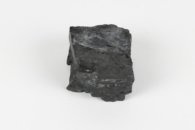
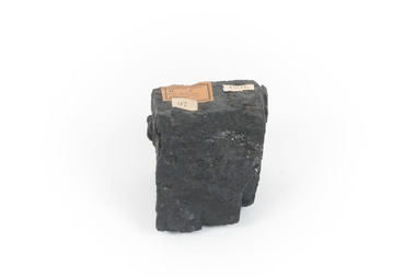
Geological specimen - Bituminous Coal, Unknown
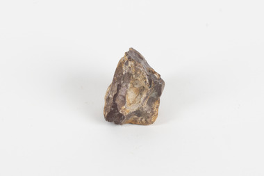
... The discovery of bituminous coal in this locality was first made in 1826 by explorer William Hovell. ...Existing Label: BITUMINOUS COAL / Locality: Cape / Patterson, VIC. ...The discovery of bituminous coal in this locality was first made in 1826 by explorer William Hovell. ...Bituminous coal is the most common type of coal, abundantly found in ancient coal deposits which can be dated back millions of years. Often referred to as soft or black coal, this specimen exhibits a high carbon content, ranging from 76-86%. It also holds a relatively high energy density (27 MJ/kg) meaning that it releases significant amounts of energy when burned. Bituminous coal is most commonly used for electricity generation, as well as in the production of steel. This particular piece of coal was collected as part of the Geological Survey of Victoria in the nineteenth century. It originates from Cape Paterson, a seaside village located in South Gippsland, Victoria (located on Bunurong Country). The discovery of bituminous coal in this locality was first made in 1826 by explorer William Hovell. More discoveries were gradually made over the following decades and in 1859 the Victorian Coal Company commenced the first active coal mining operations in the state by sinking a number of shafts and bores near the area of Cape Paterson. Evidence of this coal-focused past can be found today at the State Coal Mine Museum in the nearby town of Wonthaggi. This specimen is significant as it was collected from the locality of Cape Paterson in Victoria, an area that has since become historically instrumental in the mining of coal and other substances in the state of Victoria. This specimen is part of a larger collection of geological and mineral specimens collected from around Australia (and some parts of the world) and donated to the Burke Museum between 1868-1880. A large percentage of these specimens were collected in Victoria as part of the Geological Survey of Victoria that begun in 1852 (in response to the Gold Rush) to study and map the geology of Victoria. Collecting geological specimens was an important part of mapping and understanding the scientific makeup of the earth. Many of these specimens were sent to research and collecting organisations across Australia, including the Burke Museum, to educate and encourage further study. A solid hand-sized piece of bituminous coal with a shiny black-grey surface and jagged edges.Existing Label: BITUMINOUS COAL / Locality: Cape / Patterson, VIC. burke museum, beechworth, geological, geological specimen, state coal mine museum, wonthaggi coal mine, victorian coal company, bituminous coal, coal victoria, coal energy generation, william hovell, cape paterson, coal specimen -
 The Beechworth Burke Museum
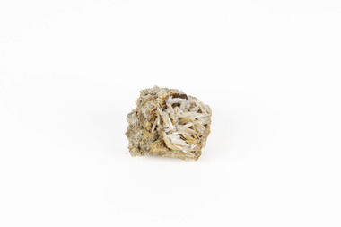
Geological specimen - Cerussite, Unknown c.1890s
... This specimen was found in Dundas (formerly Mount Dundas), a historical mining locality, mineral field and railway located on the western foothills of the West Coast Range in Western Tasmania. ...CERUSSITE / (lead carbonite) / Locality: Dundas, W. Tasmania...This specimen was found in Dundas (formerly Mount Dundas), a historical mining locality, mineral field and railway located on the western foothills of the West Coast Range in Western Tasmania. ...Named in 1845 by Wilhelm Karl von Haidinger cerussite takes its name from the Latin cerussa, meaning 'white lead'. When viewed under certain lighting conditions cerussite gives of fire and rainbow-like colours (due to its high dispersion) and it is quite sought after by geological collectors for this very reason. Cerussite is usually found in the oxidised zone of lead ore deposits. It is a very common weathering product of galena and other lead ore minerals. It is a secondary mineral, meaning it forms as a result of the alteration of pre-existing minerals in the Earth’s crust. The presence of lead in cerussite makes it potentially toxic. Historically, it has been an important source of lead, which has numerous industrial applications, including in batteries, construction materials, and radiation shielding. Cerussite has a crystal structure that belongs to the orthorhombic crystal system. Its crystal structure is characterized by a three-dimensional arrangement of atoms in a repeating pattern. The crystal lattice of cerussite consists of interconnected lead (Pb) and carbonate (CO3) ions. This crystal structure is visible in the specimen. This specimen was found in Dundas (formerly Mount Dundas), a historical mining locality, mineral field and railway located on the western foothills of the West Coast Range in Western Tasmania. During the 1890s Dundas swelled in numbers however it is now lost in a temperate rainforest and its population is now 2. The present Dundas Extended mine, about 1.5 km east of Dundas is presently worked for specimen material.Faceted cerussite gems are considered rare and valuable, given the softness of the mineral. This item is not a faceted gem however its historical and scientific research potential give it significance; mined in an Australian township, this cerussite could shed light on the now lost history of Dundas and the mining that occurred there. Additionally, the uses of this mineral in historical industrial processes give it scientific significance. Such knowledge can add to understandings of the geographical and geological nature of Western Tasmania and allow for further study of Australian geological specimens. A small lead carbonite mineral with shades of cream, white and brown throughout, flaky shards of white at base. CERUSSITE / (lead carbonite) / Locality: Dundas, W. Tasmaniadundas, tasmania, cerussite, lead, orthorhombic, geology, minerals, mining -
Ringwood and District Historical Society
Report, Ringwood Bypass and Suda-Larissa Avenue pedestrian crossing reports. 1992, 14-Jul-92
... Brief notes and a locality map issued to local householders about a meeting to discuss the Suda-Larissa Avenue pedestrian crossing....Brief notes and a locality map issued to local householders about a meeting to discuss the Suda-Larissa Avenue pedestrian crossing. ...Brief notes and a locality map issued to local householders about a meeting to discuss the Suda-Larissa Avenue pedestrian crossing. ...Brief notes and a locality map issued to local householders about a meeting to discuss the Suda-Larissa Avenue pedestrian crossing.Brief notes and a locality map issued to local householders about a meeting to discuss the Suda-Larissa Avenue pedestrian crossing. Report comprising three white A4 pages: two with typed notes and one of Ringwood Bypass notes. +Additional Keywords: Adams, Chris -
 Surrey Hills Historical Society Collection
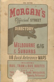
Book, Morgan's Official Street Directory, c1940s
... This Street Directory of Melbourne and suburbs, c1940s, includes a list of suburbs, their mileage from the city and how to reach them; an index to localities as well as the index to streets appearing on the maps. ...This Street Directory of Melbourne and suburbs, c1940s, includes a list of suburbs, their mileage from the city and how to reach them; an index to localities as well as the index to streets appearing on the maps. ...This Street Directory of Melbourne and suburbs, c1940s, includes a list of suburbs, their mileage from the city and how to reach them; an index to localities as well as the index to streets appearing on the maps. ...incl.index. This Street Directory of Melbourne and suburbs, c1940s, includes a list of suburbs, their mileage from the city and how to reach them; an index to localities as well as the index to streets appearing on the maps. It also shows bus routes, railways and tramways routes on the maps.incl.index. This Street Directory of Melbourne and suburbs, c1940s, includes a list of suburbs, their mileage from the city and how to reach them; an index to localities as well as the index to streets appearing on the maps. It also shows bus routes, railways and tramways routes on the maps.melbourne metropolitian area, suburbs, cities and towns, maps -
 The Beechworth Burke Museum
Geological specimen - Cinnibar
... CINNIBAR / (Mercury sulphide) / Locality: Spain....Burke Museum Beechworth Minerology Geology Geological Specimin Spain Cinnabar CINNIBAR / (Mercury sulphide) / Locality: Spain. Red and brownish red stone with some whitish silver material at the surface Geological specimen Cinnibar ...Cinnabar is naturally red, but can undergo photo-oxidation to form colloidal metallic mercury at the crystal surface. This mercury may produce a silver colourationA common red ore that is often found in locations where there has been volcanic activity and has been historically used as a red pigment as a cosmetic or for colouring stone. It is commonly used today as a method of creating mercury.Red and brownish red stone with some whitish silver material at the surface CINNIBAR / (Mercury sulphide) / Locality: Spain.burke museum, beechworth, minerology, geology, geological specimin, spain, cinnabar -
Lakes Entrance Historical Society
Map - Risk Management Proposal/Gippsland Ports
... Map showing locality and proposed boardwalk...Lakes Entrance Historical Society 4 Marine Parade Lakes Entrance gippsland Piers Boardwalk Map showing locality and proposed boardwalk Map Risk Management Proposal/Gippsland Ports ...Map showing locality and proposed boardwalkpiers, boardwalk -
Stawell Historical Society Inc
Map, Locality Plan, Shewing Lands for Sale, 1866
... Locality Plan, Shewing Lands for Sale ...Locality Plan, Shewing Lands for Sale ...Stawell Historical Society Inc 46 Longfield St Stawell grampians Stawell Locality Plan, Shewing Lands for Sale Locality Plan, Shewing Lands for Sale Map ...Locality Plan, Shewing Lands for Sale stawell -
 The Beechworth Burke Museum
Geological specimen - Common Opal, unknown
... Existing label: Common Opal / Locality unknown...Geological Specimen geology Geology Collection Burke Museum Beechworth common opal opal mineraloid Amorphous Silicates hydrated silicate Existing label: Common Opal / Locality unknown A palm-sized amorphous (non-crystallising) hydrated silicate mineraloid specimen in shades of brown, orange, and white. ...Common Opal is a mineraloid that is non crystallising and is classed as an amorphous silicate, the chemical composition for Opal is SiO2 nH2O. Opals can develop in weathered sedimentary rock typical in arid regions where limited water enters small gaps in the rock, and the silicate is hydrated. Common opals, unlike precious opals, do not exhibit ‘play of colour’ in which the colour appears to change depending on the angle of view. While precious opals are highly valuable and cut as gemstones for jewellery, common opals can be cut into inexpensive gemstones and are also mined for various uses including as ingredients in ceramics, insulation, fillers, and abrasives. The source of this common opal specimen is unknown, but common opals are found around the world, notable deposits are found in Queensland, South Australia, New South Wales, Peru, Kenya, Nevada, Oregon, and Mexico. This common opal specimen is of historic and scientific significance due to its donation in 1868 as part of the Geological Survey of Victoria and as a typical example of uncut common opal. This specimen is part of a larger collection of geological and mineral specimens collected from around Australia (and some parts of the world) and donated to the Burke Museum between 1868-1880. A large percentage of these specimens were collected in Victoria as part of the Geological Survey of Victoria that begun in 1852 (in response to the Gold Rush) to study and map the geology of Victoria. Collecting geological specimens was an important part of mapping and understanding the scientific makeup of the earth. Many of these specimens were sent to research and collecting organisations across Australia, including the Burke Museum, to educate and encourage further study.A palm-sized amorphous (non-crystallising) hydrated silicate mineraloid specimen in shades of brown, orange, and white.Existing label: Common Opal / Locality unknowngeological specimen, geology, geology collection, burke museum, beechworth, common opal, opal, mineraloid, amorphous silicates, hydrated silicate -
Lakes Entrance Historical Society
Map - Lake Tyers Beach
... Two locality maps Lake Tyers Beach ...Lakes Entrance Historical Society 4 Marine Parade Lakes Entrance gippsland Shows township and waterway Lake Tyers and Mud Island Township Islands Waterways Two locality maps Lake Tyers Beach Map Lake Tyers Beach ...Shows township and waterway Lake Tyers and Mud IslandTwo locality maps Lake Tyers Beach township, islands, waterways -
 Wodonga & District Historical Society Inc
Album - Hume Reservoir Australia Album - Plans and Progress Photos - River Murray Water Scheme, Department of Public Works, N.S.W, 1927
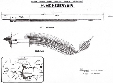
... 1. Locality Plan and Plan of Dam. The dam is about ten miles by road upstream from Albury and about three-quarters of a mile below the confluence of the Mitta Mitta River and the Murray River. ...ELEVATION" Beneath second diagram "FIG. 2. PLAN" On map "LOCALITY PLAN"...ELEVATION" Beneath second diagram "FIG. 2. PLAN" On map "LOCALITY PLAN" 1. Locality Plan and Plan of Dam. ...This set of photos is from a leather bound album bearing the inscription "HUME RESERVOIR AUSTRALIA" plus 'The Rt. Hon. L. C. M. S. Amery, P. C., M .P.' all inscribed in gold. It was presented to The Rt. Hon. L. C. M. S. Amery, P. C., M. P, Secretary of State for Dominion Affairs on the occasion of his visit to the Hume Reservoir on 2nd November 1927. This album is of local and national significance as it documents the planning and development of the Hume Reservoir up to 1927. It was the largest water reservoir in the British Empire. The album records the pioneering engineering work that went into its construction.1. Locality Plan and Plan of Dam. The dam is about ten miles by road upstream from Albury and about three-quarters of a mile below the confluence of the Mitta Mitta River and the Murray River. Its main features consist of a concrete portion across the bed of the river with earth embankment at both ends. The foundations throughout are on hard granite, found at an average depth of about 40 feet below the surface, the centre line being located to take advantage of the most favourable rock levels.Heading on page "WORKS UNDER RIVER MURRAY WATERS AGREEMENT/HUME RESERVOIR" Beneath top diagram "FIG. 1. ELEVATION" Beneath second diagram "FIG. 2. PLAN" On map "LOCALITY PLAN"hume reservoir australia, river murray waters scheme, hume weir diagrams, hume weir location -
 Ringwood and District Historical Society
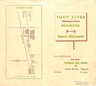
Flyer, Ringwood Mail, Retail Subdivision Brochure - Plan of New Shop Sites, Ringwood, Victoria. - circa 1950
... Double sided folded page advertising shop sites in Whitehorse Road, Ringwood, with locality plan, price list, terms of sale, summary of local facilities and services, and diagram showing layout of 9 retail allotments for sale. ...Locality plan showing shop sites for sale on Whitehorse Road, Ringwood, between New Street and Olive Grove. ...Ringwood and District Historical Society 125A Warrandyte Road Ringwood North melbourne Locality plan showing shop sites for sale on Whitehorse Road, Ringwood, between New Street and Olive Grove. ...Double sided folded page advertising shop sites in Whitehorse Road, Ringwood, with locality plan, price list, terms of sale, summary of local facilities and services, and diagram showing layout of 9 retail allotments for sale. These sites were originally zoned as residential as part of the 1926 "Olive Grove Estate" subdivision. (See Vicorian Collections Reference 5169). The 9 new shops were later allocated street numbers 58 to 64 Whitehorse Road, Ringwood.Locality plan showing shop sites for sale on Whitehorse Road, Ringwood, between New Street and Olive Grove. Sole Agents: Ringwood Real Estate Co., Station Entrance, Ringwood, (Telephone) WU6661, WU6662. -
 Ballarat Heritage Services
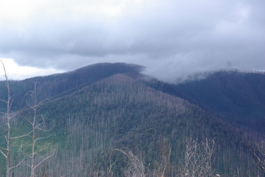
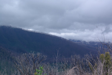
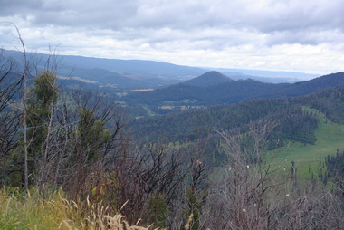
Photograph - Photograph - Colour, Clare Gervasoni, Marysville after 'Black Saturday' from Nicholl Lookout , 2012, 16/12/2012
... Colour photograph of the Marysville locality from Nicholl Lookout...Ballarat Heritage Services PO Box 2209 Bakery Hill Post Office goldfields bushfire black saturday marysville Colour photograph of the Marysville locality from Nicholl Lookout Marysville after 'Black Saturday' from Nicholl Lookout , 2012 Photograph Photograph - Colour Clare Gervasoni ...Colour photograph of the Marysville locality from Nicholl Lookoutbushfire, black saturday, marysville -
 Ballarat Heritage Services
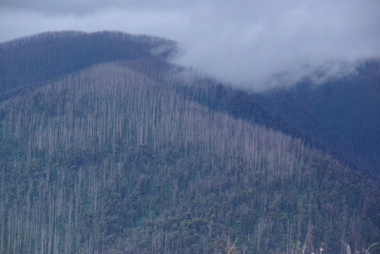
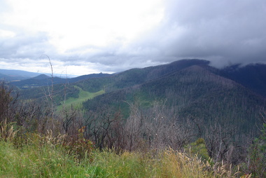
Photograph - Colour, Clare Gervasoni, Marysville after 'Black Saturday' from Nicholl Lookout , 2012, 16/12/2012
... Colour photograph of the Marysville locality from Nicholl Lookout...Ballarat Heritage Services PO Box 2209 Bakery Hill Post Office goldfields bushfire black saturday marysville Nicholl lookout Colour photograph of the Marysville locality from Nicholl Lookout Marysville after 'Black Saturday' from Nicholl Lookout , 2012 Photograph - Colour Clare Gervasoni ...Colour photograph of the Marysville locality from Nicholl Lookoutbushfire, black saturday, marysville, nicholl lookout -
 Ballarat Heritage Services
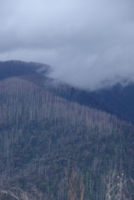
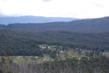
Photograph - Photograph - Colour, Clare Gervasoni, Marysville after 'Black Saturday' from Nicholl Lookout , 2012, 16/12/2012
... Colour photograph of the Marysville locality from Nicholl Lookout...Ballarat Heritage Services PO Box 2209 Bakery Hill Post Office goldfields bushfire black saturday marysville nicholl lookout Colour photograph of the Marysville locality from Nicholl Lookout Marysville after 'Black Saturday' from Nicholl Lookout , 2012 Photograph Photograph - Colour Clare Gervasoni ...Colour photograph of the Marysville locality from Nicholl Lookoutbushfire, black saturday, marysville, nicholl lookout -
 Ballarat Heritage Services
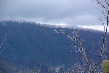
Photograph - Colour, Clare Gervasoni, Marysville after 'Black Saturday' from Nicholl Lookout , 2012, 16/12/2012
... Colour photograph of the Marysville locality from Nicholl Lookout...Ballarat Heritage Services PO Box 2209 Bakery Hill Post Office goldfields bushfire black saturday marysville nicholl lookout Colour photograph of the Marysville locality from Nicholl Lookout Marysville after 'Black Saturday' from Nicholl Lookout , 2012 Photograph - Colour Clare Gervasoni ...Colour photograph of the Marysville locality from Nicholl Lookoutbushfire, black saturday, marysville, nicholl lookout -
 Ballarat Heritage Services
Photograph - Colour, Clare Gervasoni, Marysville from Nicholl Lookout after 'Black Saturday', 2012, 16/12/2012
... Colour photograph of the Marysville locality from Nicholl Lookout...Ballarat Heritage Services PO Box 2209 Bakery Hill Post Office goldfields bushfire black saturday marysville nicholl lookout Colour photograph of the Marysville locality from Nicholl Lookout Marysville from Nicholl Lookout after 'Black Saturday', 2012 Photograph - Colour Clare Gervasoni ...Colour photograph of the Marysville locality from Nicholl Lookoutbushfire, black saturday, marysville, nicholl lookout -
 Ballarat Heritage Services
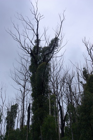
Photograph - Colour, Clare Gervasoni, Tree regrowth after 'Black Saturday' from Nicholl Lookout , 2012, 16/12/2012
... Colour photograph of the Marysville locality from Nicholl Lookout...Ballarat Heritage Services PO Box 2209 Bakery Hill Post Office goldfields bushfire black saturday marysville nicholl lookout Colour photograph of the Marysville locality from Nicholl Lookout Tree regrowth after 'Black Saturday' from Nicholl Lookout , 2012 Photograph - Colour Clare Gervasoni ...Colour photograph of the Marysville locality from Nicholl Lookoutbushfire, black saturday, marysville, nicholl lookout -
 The Beechworth Burke Museum
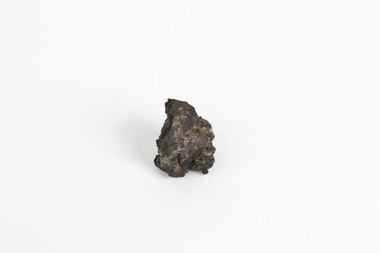
Geological specimen - Black Coal
... Geological survey / R..... S...../ Locality Cape Patterson ...Coal specimen Burke Museum Geological Survey of Victoria Geological Specimen Geology Geological survey / R..... S...../ Locality Cape Patterson Small piece of black coal with museum original label Geological specimen Black Coal ...This specimen was recovered from Wonthaggi in Victoria. Coal is a sedimentary rock which is composed of peat after it has been exposed over millions of years. This is an example of Australian black coal which is used as either thermal or coking coal for electricity generation or manufacturing processes. It is predominantly composed of Carbon which is 'C' on the periodic table of elements. This early example of a coal sample, shows the important role that coal played/plays in Australia's energy generation and manufacturing processes. This specimen is part of a larger collection of geological and mineral specimens collected from around Australia (and some parts of the world) and donated to the Burke Museum between 1868-1880. A large percentage of these specimens were collected in Victoria as part of the Geological Survey of Victoria that begun in 1852 (in response to the Gold Rush) to study and map the geology of Victoria. Collecting geological specimens was an important part of mapping and understanding the scientific makeup of the earth. Many of these specimens were sent to research and collecting organisations across Australia, including the Burke Museum, to educate and encourage further study.Small piece of black coal with museum original labelGeological survey / R..... S...../ Locality Cape Patterson coal specimen, burke museum, geological survey of victoria, geological specimen, geology -
 The Beechworth Burke Museum
Geological specimen - Native (metallic) copper, Unknown
... NATIVE (metalic) COPPER / Locality: Moonta, South Australia...Beechworth Burke Museum Geological Specimen Native Specimen Geological Mineral mineralogy indigo shire Beechworth Museum copper copper ore NATIVE (metalic) COPPER / Locality: Moonta, South Australia A small, palm-sized solid native copper mineral specimen with shades of browns, black and rustic tones throughout the specimen. ...This specimen is a native copper specimen that is metallic. Copper is typically found in the earth's crust and is often found alongside other metals such as gold, zinc, lead and silver which all belong to the same group which is the Copper/Gold group. Copper is most commonly formed from large masses of molten lava rock which has solidified in the earth's crust and over time though different sizes and speeds of crystal growth has turned into large amounts of copper, stored in porphyry copper deposits. Copper has a distinctive colour, yet can sometime appear blue and greenish which is often caused by oxidisation or a mixture of copper and other metals. This specific specimen was recovered from Moonta, South Australia. The Moonta Mining Company was established in 1861, after a Shepard in the area noticed traces of copper. This lead to a rush in the copper mining industry which was relatively young in Australia at the time, making Moonta Mining Company one of the richest in Australia. By the 1860's, South Australia had been nicknamed the "Copper Kingdom" due to its vast amount of Large copper mines and resources. As of 2016, Australia was the second largest producer of Copper internationally, following behind Chile in first place. This copper specimen is significant historically and scientifically as it is such an important metal commonly used throughout the world in various ways. Copper is an invaluable recourse used in daily life, used in most electrical appliances as it is a great conductor of heat and electricity, as well as being soft and malleable, making it easy to bend and mould into delicate sheets and wires. Copper does not corrode and is therefore used in the production of water pipes among countless other significant necessities that are often overlooked in our society. Historically, Copper holds great significance as it was the first metal used by humans. It was discovered roughly 9000 years ago and was utilised by the Neolithic Man who learnt that heating the metal made it more malleable, thus tools and utensils were made which were far superior to the previous stone tools used by humans. This history and its connection to the current and ongoing relationship between humans and copper must be preserved and highlighted as it is integral to the history of all humankind. A small, palm-sized solid native copper mineral specimen with shades of browns, black and rustic tones throughout the specimen.NATIVE (metalic) COPPER / Locality: Moonta, South Australiabeechworth, burke museum, geological specimen, native specimen, geological, mineral, mineralogy, indigo shire, beechworth museum, copper, copper ore -
 The Beechworth Burke Museum
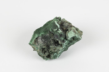
Geological specimen - Malachite, Unknown
... This particular specimen was collected from the town of Burra, South Australia as part of a geological survey undertaken during the nineteenth century. The locality (located on Ngadjuri Country) has a long history of mining, particularly in copper mining, as the area is rich in copper deposits. ...Existing Label: MALACHITE / Locality: Burra / S. Aust. Other Label: Confirmed / as Malachite / C. ...This particular specimen was collected from the town of Burra, South Australia as part of a geological survey undertaken during the nineteenth century. The locality (located on Ngadjuri Country) has a long history of mining, particularly in copper mining, as the area is rich in copper deposits. ...Malachite is a copper carbonate hydroxide mineral. It has a chemical composition of Cu2(CO3)(OH)2. It often forms within limestone where a subsurface chemical environment favourable for the formation of carbonate minerals can occur. It is a substance that can be found in many different parts of the world including: Australia, USA, Russia and the Democratic Republic of Congo. Malachite has historically been used to produce copper, with mining of the mineral dating back over a period of four thousand years. Due to its beautiful green colourations, it is also commonly used for aesthetic purposes such as in the production of sculptures and jewellery. This particular specimen was collected from the town of Burra, South Australia as part of a geological survey undertaken during the nineteenth century. The locality (located on Ngadjuri Country) has a long history of mining, particularly in copper mining, as the area is rich in copper deposits. The first significant discovery of this was made in Burra (Burra Burra Mine) in 1845 and, at the time, the mine was the largest and richest of its kind in the world, producing nearly five percent of the total world copper output. This specimen is significant as it is considered to be a rare gemstone, as many of the original deposits for the stones are significantly depleted, leaving behind very few sources. This specimen is part of a larger collection of geological and mineral specimens collected from around Australia (and some parts of the world) and donated to the Burke Museum between 1868-1880. A large percentage of these specimens were collected in Victoria as part of the Geological Survey of Victoria that begun in 1852 (in response to the Gold Rush) to study and map the geology of Victoria. Collecting geological specimens was an important part of mapping and understanding the scientific makeup of the earth. Many of these specimens were sent to research and collecting organisations across Australia, including the Burke Museum, to educate and encourage further study.A solid palm-sized copper carbonate hydroxide mineral with patterns of green colourations Existing Label: MALACHITE / Locality: Burra / S. Aust. Other Label: Confirmed / as Malachite / C. Willman / 15/4/1 / + Bill Birch burke museum, beechworth, geological, geological specimen, malachite, gemstone, green gemstone, burra, burra burra mine, burra south australia, carbonate mineral, copper, copper mining, copper mining burra, carbonate hydroxide mineral, copper carbonate, malachite mining, malachite burra, monster mine