Showing 14 items matching "locality store"
-
 Greensborough Historical Society
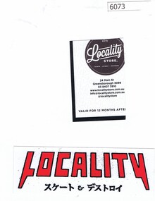
Business card and Sticker, Locality Store, 2018_
... Locality Store...locality store...The Locality Store is a young mens' clothing store, situated at 24 Main Street Greensborough...Locality Store...Greensborough Historical Society 34A Glenauburn Road Lower Plenty Lower Plenty melbourne The Locality Store is a young mens' clothing store, situated at 24 Main Street Greensborough locality store main street greensborough Black & white, one-sided card; and sticker with red text Locality Store Business card and Sticker Locality Store ...The Locality Store is a young mens' clothing store, situated at 24 Main Street GreensboroughBlack & white, one-sided card; and sticker with red textlocality store, main street greensborough -
 Greensborough Historical Society
Poster - Advertising Leaflet, Electric Station Estate; Watsonia; Saturday 16th October 1926, 16/10/1926
... This brochure contains a locality plan and drawing of the general store. (Refer 4526 for the other brochure for this auction) Auctioneer: Knight & Harwood....One page B & W Photocopy (laminated) of auction brochure, with drawing of general store and locality plan...This brochure contains a locality plan and drawing of the general store. (Refer 4526 for the other brochure for this auction) Auctioneer: Knight & Harwood. watsonia railway station watsonia electric station estate One page B & W Photocopy (laminated) of auction brochure, with drawing of general store and locality plan Electric Station Estate; Watsonia; Saturday 16th October 1926 Poster Advertising Leaflet ...This is one of two brochures advertising the auction of the last 50 allotments of the Electric Station Estate, Watsonia, near the new railway station. This brochure contains a locality plan and drawing of the general store. (Refer 4526 for the other brochure for this auction) Auctioneer: Knight & Harwood.One page B & W Photocopy (laminated) of auction brochure, with drawing of general store and locality planwatsonia railway station, watsonia, electric station estate -
 Warrnambool and District Historical Society Inc.
Book, Road register loose binder, 1953
... locality, wards, allotment numbers, lodged plan numbers, footpaths and printed information from the Victorian Local Government Departments. It sometimes gives the origin of the name of the street and some other miscellaneous information is included. It is presumed that the information contained therein has now been stored...locality, wards, allotment numbers, lodged plan numbers, footpaths and printed information from the Victorian Local Government Departments. It sometimes gives the origin of the name of the street and some other miscellaneous information is included. It is presumed that the information contained therein has now been stored ...This is an Alphabetical Register of the streets in Warrnambool as listed by Warrnambool City Council officers. It appears to have been a working register used in the 1950s, 60s and 70s and information has been added to the entries as it became available and as Council works were carried out in these streets. It contains information on the locality, wards, allotment numbers, lodged plan numbers, footpaths and printed information from the Victorian Local Government Departments. It sometimes gives the origin of the name of the street and some other miscellaneous information is included. It is presumed that the information contained therein has now been stored electronically. This is a most important ledger as it contains much valuable historical information on Warrnambool streets. It will be of great use to researchers. This is a loose leaf binder with a black leather cover and a black metal and cord binding mechanism. The pages are unnumbered but there is provision for insertion or removal of pages and there are leather alphabetical tabs protruding from the pages. The pages have blue ruled lines with blue lined margins and headings. The streets in Warrnambool are listed alphabetically and the information in the register contains both typed and handwritten material. There are also printed notices from the Victorian Local Government department, extracts from newspapers, copies of letters and plans of street subdivisions. There is one loose page.warrnambool city council, warrnmbool streets register -
 Eltham District Historical Society Inc
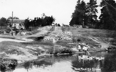
Negative - Photograph, Village Pond, near Main Road, Eltham, c.1908
... The pond and its locality was described in an article about Eltham published in The Australasian, May 2, 1903 - “There is the village pond (so essentially English), reflecting in its clear water a quaint cottage, dwarfed by a huge gum tree, an old smithy, and a hostelry, built quite fifty years ago, the flooring-boards of which the landlord informed me with pride were of Singapore cedar, and quite fit for another fifty years' wear. Then there are the village school, the shoemaker's, the drapery store...The pond and its locality was described in an article about Eltham published in The Australasian, May 2, 1903 - “There is the village pond (so essentially English), reflecting in its clear water a quaint cottage, dwarfed by a huge gum tree, an old smithy, and a hostelry, built quite fifty years ago, the flooring-boards of which the landlord informed me with pride were of Singapore cedar, and quite fit for another fifty years' wear. Then there are the village school, the shoemaker's, the drapery store ...Village Pond, near Main Road, Eltham, c.1908 Reproduced on p57 of 'Pioneers & Painters'. Looking up Dalton Street from across Maria Street (Main Road), near Whitecloud (Jarrold’s cottage) and the Bootmaker’s cottage, to the left (out of view) of the photographer. The residence of the Head Teacher, Eltham State School No. 209, can be seen on the right, the Grant house on the left (site of present day Eltham Clinic). The willow trees south of Jarrold’s Cottage today mark the site of the old pond, which the Eltham Shire Council evidently filled in to stop mosquitos breeding. The pond and its locality was described in an article about Eltham published in The Australasian, May 2, 1903 - “There is the village pond (so essentially English), reflecting in its clear water a quaint cottage, dwarfed by a huge gum tree, an old smithy, and a hostelry, built quite fifty years ago, the flooring-boards of which the landlord informed me with pride were of Singapore cedar, and quite fit for another fifty years' wear. Then there are the village school, the shoemaker's, the drapery store, and the butcher's shop, all seemingly as they were when first they were erected many years ago.”This photo forms part of a collection of photographs gathered by the Shire of Eltham for their centenary project book,"Pioneers and Painters: 100 years of the Shire of Eltham" by Alan Marshall (1971). The collection of over 500 images is held in partnership between Eltham District Historical Society and Yarra Plenty Regional Library (Eltham Library) and is now formally known as the 'The Shire of Eltham Pioneers Photograph Collection.' It is significant in being the first community sourced collection representing the places and people of the Shire's first one hundred years.Digital image 4 x 5 inch B&W Neg Print 16.5 x 25 cm (2) and 9 x 12.5 cm Postcard 9 x 14 cmOn one print "57 and 11 3/8' x 10' deep"shire of eltham pioneers photograph collection, dalton street, duck pond, eltham, grant house, main road, maria street, village pond -
 Wodonga & District Historical Society Inc
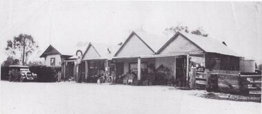
Photograph - Little River (Lone Pine) Store, c1940
... store and sub agency for Bank of NSW and also served as a post office. Mrs Hart also operated a small telephone exchange. In 1974 it was for put up for sale for $39,000 plus SAV. It was eventually acquired by Albury Wodonga Development Corporation in about1980. A bid to retain the name Lone Pine as a locality...store and sub agency for Bank of NSW and also served as a post office. Mrs Hart also operated a small telephone exchange. In 1974 it was for put up for sale for $39,000 plus SAV. It was eventually acquired by Albury Wodonga Development Corporation in about1980. A bid to retain the name Lone Pine as a locality ...Little River (Lone Pine) Store at Killara was built in late 1920s by Harold Harris. Harold and his mother Emily Harris nee Farrell owned Killara Station. He had served at Lone Pine during World War 1 so named the area in honour of that field of battle. Bill Hart added a lubritorium or service station in the late 1950s. It was then also a general store and sub agency for Bank of NSW and also served as a post office. Mrs Hart also operated a small telephone exchange. In 1974 it was for put up for sale for $39,000 plus SAV. It was eventually acquired by Albury Wodonga Development Corporation in about1980. A bid to retain the name Lone Pine as a locality failed. These images are significant because they capture a building which served the community in the Wodonga area and has since been demolished.Two black and white images of the Lone Pine Store and Service Station at Killara.Lone Pine Store and advertising postershistoric sites wodonga, lone pine killara -
 Southern Sherbrooke Historical Society Inc.
Map - photocopy
... The original maps are stored in large bound account books and were originally the propert of McNally Real Estate. The books are held (in 2 land sales advertisements subdivision "Villette Estate" in top LH corner, "Locality Plan" in bottom LH corner, "Not in sale" written on one block and crossed out. ...A photocopy taken from the original land sale map provided to the society through Karel Coxell of Stockdale & Leggo. The original maps are stored in large bound account books and were originally the propert of McNally Real Estate. The books are held (in 2A3 photocopy of plan of survey of part of Crown Allotments 20 & 21, section C, parish of Narre Worran, County of Mornington. Clements Ave and environs in Belgrave Heights"Villette Estate" in top LH corner, "Locality Plan" in bottom LH corner, "Not in sale" written on one block and crossed out. All handwritten in pencil on original. "Colby Drive " and "Verona Street" added in pencil to copy.land sales, advertisements, subdivision -
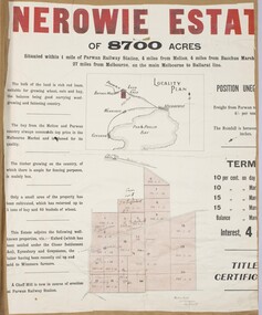 Bacchus Marsh & District Historical Society
Map, Nerowie Estate Land Sale 1910
... locality of Parwan only a few kilometers east of Bacchus Marsh. It had once formed a large part of the land owned by the pioneering Staughton family. Nerowie Estate Parwan Land Sales Parwan Land Sales Bacchus Marsh Staughton Family Bacchus Marsh A single page paper map showing the land offered for sale from the Nerowie Estate at Parwan near Bacchus Marsh in 1910. The map is pasted into a bound volume containing 76 maps or plans in total. High resolution digital image stored ...The Nerowie Estate was a large rural property of 8,700 acres (3520 hectares) near the locality of Parwan only a few kilometers east of Bacchus Marsh. It had once formed a large part of the land owned by the pioneering Staughton family.A single page paper map showing the land offered for sale from the Nerowie Estate at Parwan near Bacchus Marsh in 1910. The map is pasted into a bound volume containing 76 maps or plans in total. High resolution digital image stored on BMDHS computer network. nerowie estate parwan, land sales parwan, land sales bacchus marsh, staughton family bacchus marsh -
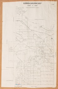 Bacchus Marsh & District Historical Society
Map, Gorrockburkchap Parish Map, County of Grant
... locality of Rowsley is situated within this parish area. Gorrockburkchap Parish Maps Rowsley Victoria Maps A single page paper map showing the parish plan for Gorrockburkchap in the County of Grant. The map is pasted into a bound volume containing 76 maps or plans in total. High resolution digital image stored ...The parish of Gorrockburkchap (sometimes spelled Gorrockburkghap) lies to the west and south west of the township of Bacchus Marsh. The locality of Rowsley is situated within this parish area.A single page paper map showing the parish plan for Gorrockburkchap in the County of Grant. The map is pasted into a bound volume containing 76 maps or plans in total. High resolution digital image stored on BMDHS computer network. gorrockburkchap parish maps, rowsley victoria maps -
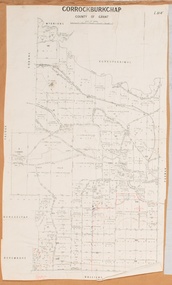 Bacchus Marsh & District Historical Society
Map, Gorrockburkchap Parish Map, County of Grant c.1915
... locality of Rowsley is situated within this parish area. Gorrockburkchap Parish Maps Rowsley Victoria Maps A single page paper map showing the parish plan for Gorrockburkchap in the County of Grant. The map is pasted into a bound volume containing 76 maps or plans in total. High resolution digital image stored ...The parish of Gorrockburkchap (sometimes spelled Gorrockburkghap) lies to the west and south west of the township of Bacchus Marsh. The locality of Rowsley is situated within this parish area.A single page paper map showing the parish plan for Gorrockburkchap in the County of Grant. The map is pasted into a bound volume containing 76 maps or plans in total. High resolution digital image stored on BMDHS computer network. gorrockburkchap parish maps, rowsley victoria maps -
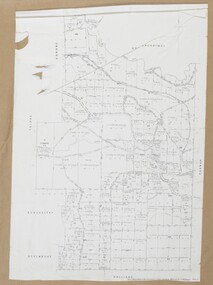 Bacchus Marsh & District Historical Society
Map, Gorrockburkchap Parish Map, County of Grant c.1906
... locality of Rowsley is situated within this parish area. Gorrockburkchap Parish Maps Rowsley Victoria Maps Bacchus Marsh Region Parish Plans A single page paper map showing the parish plan for Gorrockburkchap in the County of Grant. A cadastral map showing parish boundaries and land ownership The map is pasted into a bound volume containing 76 maps or plans in total. High resolution digital image stored ...The parish of Gorrockburkchap (sometimes spelled Gorrockburkghap) lies to the west and south west of the township of Bacchus Marsh. The locality of Rowsley is situated within this parish area.A single page paper map showing the parish plan for Gorrockburkchap in the County of Grant. A cadastral map showing parish boundaries and land ownership The map is pasted into a bound volume containing 76 maps or plans in total. High resolution digital image stored on BMDHS computer network. gorrockburkchap parish maps, rowsley victoria maps, bacchus marsh region parish plans -
 Bacchus Marsh & District Historical Society
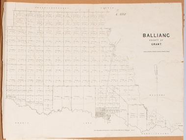
Map, Balliang Parish Map, County of Grant c.1907
... This parish area contains the localities of Balliang and Balliang East and is located south of the township of Bacchus Marsh. The map is pasted into a bound volume containing 76 maps or plans in total. High resolution digital image stored...This parish area contains the localities of Balliang and Balliang East and is located south of the township of Bacchus Marsh. The map is pasted into a bound volume containing 76 maps or plans in total. High resolution digital image stored ...A single page paper map showing parish plan map for Balliang. This parish area contains the localities of Balliang and Balliang East and is located south of the township of Bacchus Marsh. The map is pasted into a bound volume containing 76 maps or plans in total. High resolution digital image stored on BMDHS computer network. balliang victoria maps, balliang parish maps -
 Bacchus Marsh & District Historical Society
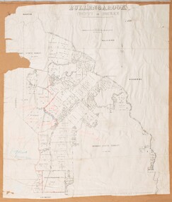
Map, Bullengarook Parish, County of Bourke
... locality of Bullengarook and parts of the Wombat State Forest and is close to the town of Gisborne. A cadastral map showing land ownership. The map is not dated but a very similar map held by the State Library of Victoria is estimated to date from about 1927. The map is pasted into a bound volume containing 76 maps or plans in total. High resolution digital image stored...locality of Bullengarook and parts of the Wombat State Forest and is close to the town of Gisborne. A cadastral map showing land ownership. The map is not dated but a very similar map held by the State Library of Victoria is estimated to date from about 1927. The map is pasted into a bound volume containing 76 maps or plans in total. High resolution digital image stored ...An undated parish plan map for the parish of Bullegarook. This parish area is close to the Bacchus Marsh district and borders some of the areas contained within the former Bacchus Marsh Shire and present day Moorabool Shire.A single page paper map showing the parish plan map for Bullengarook. This parish area contains the locality of Bullengarook and parts of the Wombat State Forest and is close to the town of Gisborne. A cadastral map showing land ownership. The map is not dated but a very similar map held by the State Library of Victoria is estimated to date from about 1927. The map is pasted into a bound volume containing 76 maps or plans in total. High resolution digital image stored on BMDHS computer network. bullengarook parish maps -
 Bacchus Marsh & District Historical Society
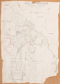
Map, Bullengarook Parish, County of Bourke
... locality of Bullengarook and parts of the Wombat State Forest and is close to the town of Gisborne. A cadastral map showing land ownership. The map is not dated but a very similar map held by the State Library of Victoria is estimated to date from about 1927. The map is pasted into a bound volume containing 76 maps or plans in total. High resolution digital image stored...locality of Bullengarook and parts of the Wombat State Forest and is close to the town of Gisborne. A cadastral map showing land ownership. The map is not dated but a very similar map held by the State Library of Victoria is estimated to date from about 1927. The map is pasted into a bound volume containing 76 maps or plans in total. High resolution digital image stored ...An undated parish plan map for the parish of Bullegarook. This parish area is close to the Bacchus Marsh district and borders some of the areas contained within the former Bacchus Marsh Shire and present day Moorabool Shire.A single page paper map showing the parish plan map for Bullengarook. This parish area contains the locality of Bullengarook and parts of the Wombat State Forest and is close to the town of Gisborne. A cadastral map showing land ownership. The map is not dated but a very similar map held by the State Library of Victoria is estimated to date from about 1927. The map is pasted into a bound volume containing 76 maps or plans in total. High resolution digital image stored on BMDHS computer network. bullengarook parish maps -
 Bacchus Marsh & District Historical Society
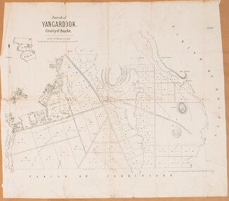
Map, Parish of Yangardook, County of Bourke 1876
... locality of Toolern Vale lies in the centre of this parish. Yangardook Parish Maps Toolern Vale Victoria Maps Photo lithographed at the Department of Lands and Survey, Melbourne by J. Noone, 1.8.76 A single page paper map showing the plan for the Parish of Yangardook in the in the County of Bourke. Scale 40 chains to 1 inch. The map is pasted into a bound volume containing 76 maps or plans in total. High resolution digital image stored ...The parish of Yangardook lies directly north of the township of Melton. The locality of Toolern Vale lies in the centre of this parish. A single page paper map showing the plan for the Parish of Yangardook in the in the County of Bourke. Scale 40 chains to 1 inch. The map is pasted into a bound volume containing 76 maps or plans in total. High resolution digital image stored on BMDHS computer network. Photo lithographed at the Department of Lands and Survey, Melbourne by J. Noone, 1.8.76yangardook parish maps, toolern vale victoria maps