Showing 696 items matching "location map"
-
 Federation University Historical Collection
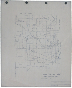
Map, Shire of Ballarat Road Location Map, 1968, 05/06/2014
... Shire of Ballarat Road Location Map, 1968...White paper road location map. Scale 1 mile to 1 inch...Barker Library (top floor) Mount Helen goldfields ballarat shire of ballarat roads dowling forest lake burumbeet lake learmonth ascot windermere tourello White paper road location map. Scale 1 mile to 1 inch Shire of Ballarat Road Location Map, 1968 Map Map ...White paper road location map. Scale 1 mile to 1 inchballarat, shire of ballarat, roads, dowling forest, lake burumbeet, lake learmonth, ascot, windermere, tourello -
 Bendigo Historical Society Inc.
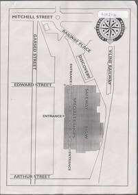
Flyer - HUGH ENNIS COLLECTION: FLYER SHOWS LOCATION MAP FOR THE OPENING OF THE BENDIGO MARKETPLACE ON TUESDAY 31ST OCTOBER 1995, 31/10/1995
... HUGH ENNIS COLLECTION: FLYER SHOWS LOCATION MAP FOR THE OPENING OF THE BENDIGO MARKETPLACE ON TUESDAY 31ST OCTOBER 1995...Flyer shows location map for the opening of the Bendigo Marketplace on Tuesday 31st October 1995...History House 11 Mackenzie Street Bendigo goldfields Flyer shows location map for the opening of the Bendigo Marketplace on Tuesday 31st October 1995 Flyer HUGH ENNIS COLLECTION: FLYER SHOWS LOCATION MAP FOR THE OPENING OF THE BENDIGO MARKETPLACE ON TUESDAY 31ST OCTOBER 1995 ...Flyer shows location map for the opening of the Bendigo Marketplace on Tuesday 31st October 1995 -
 Greensborough Historical Society
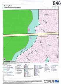
Map, Plenty River Children's Cemetery - location map, 1848-1860
... Plenty River Children's Cemetery - location map...One page map accompanies article item #804 Plenty River Children's Cemetery - location map Map Map Greensborough Historical Society ...The unmarked graves of the children of two Greensborough pioneer families lie in a private cemetery on the Plenty River. Burials occurred between 1848 and 1860.The significance lies in the association with two of the pioneer families of the Greensborough district. Descendants of both families still live in the area.One page map accompanies article item #804 -
 Croydon Conservation Society Inc.
Map, Hand drawn location map of Cheong Wildflower Sanctuary, Croydon 1991
... Hand drawn location map of Cheong Wildflower Sanctuary, Croydon 1991...Croydon melbourne Handwritten inscription on top of map: Croydon 1991 A4 sized handwritten map Hand drawn location map of Cheong Wildflower Sanctuary, Croydon 1991 Map ...A4 sized handwritten mapHandwritten inscription on top of map: Croydon 1991 -
 Croydon Conservation Society Inc.
Map, Birts Hill Reserve Croydon North - location map
... Birts Hill Reserve Croydon North - location map...Croydon melbourne Map extract Birts Hill Reserve Croydon North - location map Map ...Map extract -
University of Melbourne, Burnley Campus Archives
Plan, V.C.A.H Burnley Location map, c.1991
... V.C.A.H Burnley Location map...V.C.A.H Burnley Location map Plan ...Plan of the Campus with buildings named.vcah, burnley campus -
Merbein District Historical Society
Document, Merbein Cemetery Location map, unknown
... Merbein Cemetery Location map...Merbein District Historical Society 36 Box St Merbein the-murray Merbein township Cemetery Merbein Cemetery Location map Document ...merbein township, cemetery -
 Sunshine and District Historical Society Incorporated
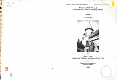
Document - Brimbank City Council Post-contact Cultural Heritage Study Volume 4 Location Maps, 2000
... Brimbank City Council Post-contact Cultural Heritage Study Volume 4 Location Maps...Brimbank City Council Post-contact Cultural Heritage Study Volume 4 Location Maps by Gary Vines Melbourne's Living Museum of the Wesy...City of Brimbank Brimbank City Council Post-contact Cultural Heritage Study Volume 4 Location Maps by Gary Vines Melbourne's Living Museum of the Wesy Brimbank City Council Post-contact Cultural Heritage Study Volume 4 Location Maps Document Brimbank City Council Post-contact Cultural Heritage Study Volume 4 Location Maps ...Brimbank City Council Post-contact Cultural Heritage Study Volume 4 Location Maps by Gary Vines Melbourne's Living Museum of the Wesycity of brimbank -
Whitehorse Historical Society Inc.
Pamphlet, Schwerkolt Cottage Mitcham
... Schwerkolt Cottage with photographs and location map....A pamphlet issued by City of Nunawading on Schwerkolt Cottage with photographs and location map....Whitehorse Historical Society Inc. 2-10 Deep Creek Road Mitcham melbourne Schwerkolt Cottage with photographs and location map. Schwerkolt Cottage City of Nunawading A pamphlet issued by City of Nunawading A pamphlet issued by City of Nunawading on Schwerkolt Cottage with photographs and location map. ...A pamphlet issued by City of NunawadingA pamphlet issued by City of Nunawading on Schwerkolt Cottage with photographs and location map.A pamphlet issued by City of Nunawading schwerkolt cottage, city of nunawading -
 Melbourne Tram Museum
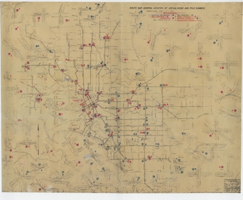
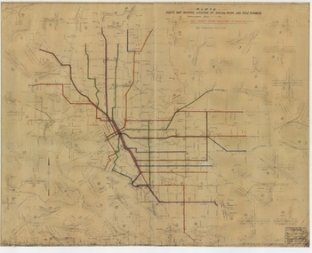
Drawing, Melbourne & Metropolitan Tramways Board (MMTB), "Route Map showing location of special work and pole numbers" "substations", late 1942
... "Route Map showing location of special work and pole numbers" "substations"...Map of the system shown at two inches = 1 mile. Drawing No. P5799. Shows crossovers, track layouts at junctions, signal cabins roads, railways, and stations. Originally signed by Perway Engineer - 20/12/1940, though originally drawn in 1922. The plan shows the lines to Maribyrnong Munitions works along Cordite Ave and Wests Road and the track from Moonee Ponds to Union Road, opened in July 1941, and the extension to Essendon Airport built in 1942, but not the Queen St North Essendon substation. Shows underground cables, tram and bus depot, workshop locations...Drawing - dyeline cloth backed print - titled - "Route Map showing location of special work and pole numbers" and subtitled - "Substations". ..."Route Map showing location of special work and pole numbers" "substations" Drawing Melbourne & Metropolitan Tramways Board (MMTB) ...Map of the system shown at two inches = 1 mile. Drawing No. P5799. Shows crossovers, track layouts at junctions, signal cabins roads, railways, and stations. Originally signed by Perway Engineer - 20/12/1940, though originally drawn in 1922. The plan shows the lines to Maribyrnong Munitions works along Cordite Ave and Wests Road and the track from Moonee Ponds to Union Road, opened in July 1941, and the extension to Essendon Airport built in 1942, but not the Queen St North Essendon substation. Shows underground cables, tram and bus depot, workshop locations, and substation locations and their priority.Yields information about the MMTB substation locations in 1942.Drawing - dyeline cloth backed print - titled - "Route Map showing location of special work and pole numbers" and subtitled - "Substations". trams, tramways, mmtb, trackwork, tramways, junction, map, world war 2, substation -
 Melbourne Tram Museum
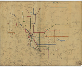
Drawing, Melbourne & Metropolitan Tramways Board (MMTB), "Route Map showing location of special work and pole numbers" "Electric Tramway Routes - showing routes in colours and numbers", late 1941
... "Route Map showing location of special work and pole numbers" "Electric Tramway Routes - showing routes in colours and numbers"...Drawings - dyeline cloth backed print - titled - "Route Map showing location of special work and pole numbers" and subtitled - "Electric Tramway Routes - showing routes in colours and numbers". ..."Route Map showing location of special work and pole numbers" "Electric Tramway Routes - showing routes in colours and numbers" Drawing Melbourne & Metropolitan Tramways Board (MMTB) ...Map of the system shown at two inches = 1 mile. Drawing No. P5799. Shows crossovers, track layouts at junctions, signal cabins roads, railways and stations. Originally signed by Perway Engineer - 20/12/1940, though originally drawn in 1922. Has been marked up in coloured pencil to show the routes and route numbers. The plan shows the lines to Maribyrnong Munitions works along Cordite Ave and Wests Road and the track from Moonee Ponds to Union Road, which opened in July 1941, but not the extension to Essendon Airport built-in 1942. See Reg Item 1561 for a 1963 version and 1683 for a 1987 versionDemonstrates the use of a MMTB drawing to show tram routes and their route numbers at the time.Drawings - dyeline cloth backed print - titled - "Route Map showing location of special work and pole numbers" and subtitled - "Electric Tramway Routes - showing routes in colours and numbers". trams, tramways, mmtb, trackwork, tramways, junction, map, world war 2 -
 Greensborough Historical Society
Business Card, Clements Avenue Automotive, Clements Avenue Automotive, Bundoora, 2018c
... Location map, contact details...Greensborough Historical Society 34A Glenauburn Road Lower Plenty Lower Plenty melbourne Clements Avenue Automotive is an automobile repair and service business in Bundoora automotive repairs bundoora clements avenue bundoora Location map, contact details Business card, printed in colour both sides Clements Avenue Automotive, Bundoora Business Card Clements Avenue Automotive ...Clements Avenue Automotive is an automobile repair and service business in BundooraBusiness card, printed in colour both sidesLocation map, contact detailsautomotive repairs, bundoora, clements avenue bundoora -
 Bendigo Military Museum
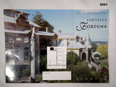
Flyer - Visit Historical Lansell's Fortuna
... The flyer contains a photo of part of Fortuna Villa on the front side and a simple location map. Coloured photos on the reverse side plus a short history and contact details for Sunday tours and group tours by arrangement on Saturdays, Sundays and public holidays. ...Contains a number of coloured photos of Fortuna Villa and includes a location map....Contains a number of coloured photos of Fortuna Villa and includes a location map. Visit Historical Lansell's Fortuna Flyer Visit Historical Lansell's Fortuna ...The flyer contains a photo of part of Fortuna Villa on the front side and a simple location map. Coloured photos on the reverse side plus a short history and contact details for Sunday tours and group tours by arrangement on Saturdays, Sundays and public holidays. The Villa was the home to the Army Survey Regiment from 1942 to 1996.A double sided coloured A4 sized Flyer. Contains a number of coloured photos of Fortuna Villa and includes a location map.royal australian survey corps, rasvy, fortuna, army survey regiment, army svy regt, asr -
Federation University Historical Collection
Document - SMB Documents E.J. Barker, Various School of Mines Ballarat Papers collected by E.J. Barker
... ...Location Map...School of Mines is a predecessor of Federation University Planning Requirements Individual Rooms Dr Ron Wild School of mines and industries Ballarat Institute Profile Location Map University of Ballarat Campus Plan Great Hall/Arts Complex Notes 1970-72 Building Program Operations and Decisions Report to Council Visit by Principal Priorities Electrical Engineering Mt Helen Minutes of Special Council Meeting University of Melbourne Engineering Mt Helen Development Report Administration Building Technical Art School Former Ballarat Gaol The Court House SMB Community Centre Trust News Articles Discovery Day K.J. ...E.J. Barker is a past principal of the School of Mines Ballarat and the Library at the Mt Helen Campus is named after him. School of Mines is a predecessor of Federation UniversityLetters, Reports Plans, Ephemera and Clipboard associated with E.J. Barker and the School of Mines Ballaratplanning requirements, individual rooms, dr ron wild, school of mines and industries ballarat, institute profile, location map, university of ballarat, campus plan, great hall/arts complex, notes, 1970-72 building program, operations and decisions, report to council, visit by principal, priorities, electrical engineering, mt helen, minutes of special council meeting, university of melbourne, engineering, mt helen development report, administration building, technical art school, former ballarat gaol, the court house, smb community centre, trust news, articles, discovery day, k.j. flecknoe, retirement, membership of sub committee, n.a crouch, e.j. barker, k.l. cross, w.j. gribble, l.f.j. hillman, r.c lovett, d. nicholson, g. robertson, p.r. shiells, b. tanner, r. feary, i. harris, b.c. mclennan, m. stevens, t.a. wiseman, d.r. bolster, p.h. dixon, r. dunlop, r. furness, e.j. lumsdon, a. mccaffrey, p.r. davies, d. farnsworth, j. harrison, k. mcfarlane, j. mills, s.a. mendelson, i. robinson, d.j. fraser, j. van dreven, k. alsop, b. bridges, m. palmer, r. sutton, l. snibson, h. van hammond, t. runnalls, p. sculley, g. shearer, t. slater, michael ronaldson, robert lovett, edward john barker, e.j. barker building, council membership, clipboard, n.g curry, state college of victoria, articles of association, memorandum, australian conference of principles of colleges of advanced education, commonwealth ministerial working party, victorian post secondary education commission, australian institute of physics symposium, royal australian institute of public administration, premier of victoria, r.j. hamer, m.b. john, new south wales institute of technology, phone messages, peter o'loughlin, annual report, signing of agreement, position description, certificates, fifth form -
 Croydon Conservation Society Inc.
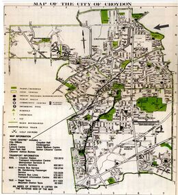
Map, City of Croydon Map showing location of Brushy Creek Croydon
... City of Croydon Map showing location of Brushy Creek Croydon...Croydon melbourne Map of 'City of Croydon' showing council reserves including Barngeong Reserve and Brushy Creek Digitised paper map City of Croydon Map showing location of Brushy Creek Croydon Map ...Map of 'City of Croydon' showing council reserves including Barngeong Reserve and Brushy CreekDigitised paper map -
 Melbourne Tram Museum
Drawing, Melbourne & Metropolitan Tramways Board (MMTB), "Route Map showing location of special work and pole numbers" "All night tram routes in colours", late 1941
... "Route Map showing location of special work and pole numbers" "All night tram routes in colours"...Drawings - dyeline cloth-backed print - titled - "Route Map showing the location of special work and pole numbers" and subtitled - "All night tram routes in colours". ..."Route Map showing location of special work and pole numbers" "All night tram routes in colours" Drawing Melbourne & Metropolitan Tramways Board (MMTB) ...Map of the system shown at two inches = 1 mile. Drawing No. P5799. Shows crossovers, track layouts at junctions, signal cabins roads, railways, and stations. Originally signed by Perway Engineer - 20/12/1940, though originally drawn in 1922. Has been marked up in colour pencil to show the all-night routes and the individual services. The plan shows the lines to Maribyrnong Munitions works along Cordite Ave and Wests Road and the track from Moonee Ponds to Union Road, opened in July 1941, but not the extension to Essendon Airport built in 1942.Demonstrates a detail drawing of Melbourne tramways, junctions and pole numbers.Drawings - dyeline cloth-backed print - titled - "Route Map showing the location of special work and pole numbers" and subtitled - "All night tram routes in colours". trams, tramways, mmtb, trackwork, tramways, junction, map, world war 2, night trams -
Moorabbin Air Museum
Letter (item) - Includes details of dress code etc. map of location in Huntington area, Reunion invitation to RAF Wyton
... Includes details of dress code etc. map of location in Huntington area...Moorabbin Air Museum Moorabbin Airport 12 First Street Moorabbin melbourne Reunion invitation to RAF Wyton Letter Includes details of dress code etc. map of location in Huntington area ... -
 Ringwood and District Historical Society
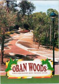
Document - Land Sale Folder, Oban Woods Subdivision, Ringwood North, Vic., - circa 1997
... Folder containing multi-fold colour pamphlet advertising Lots 6 to 12 of Oban Woods Estate with location map and summary of subdivision features. ...Estate plan includes Oban Woods (thoroughfare) and Chifley Parade. Location map of area shows development site of Oban Woods Estate off Oban Road and Kubis Drive, Ringwood North. ...Folder containing multi-fold colour pamphlet advertising Lots 6 to 12 of Oban Woods Estate with location map and summary of subdivision features. ...Folder containing multi-fold colour pamphlet advertising Lots 6 to 12 of Oban Woods Estate with location map and summary of subdivision features. A4 size attachments include subdivision layout of Lots 2 to 25 with summary of property sizes and undated indications of whether sold or still available at the time, with price where known. Dates not documented however early sales within the development took place around 1997.Estate plan includes Oban Woods (thoroughfare) and Chifley Parade. Location map of area shows development site of Oban Woods Estate off Oban Road and Kubis Drive, Ringwood North. Agents - R.E. Appleby Ringwood Pty Ltd., 170 Warrandyte Road Ringwood North 3134, Telephone 9876 4222, Fax 9876 4209. -
University of Melbourne, Burnley Campus Archives
Pamphlet (Collection), Pamphlets: Bachelor of Applied Science (Horticulture); Graduate Diploma in Horticulture; Associate Diploma in Horticulture
... 3 small pamphlets outlining courses, and including a location map...University of Melbourne, Burnley Campus Archives 500 Yarra Boulevard Richmond melbourne VCAH Burnley College of Horticulture Diploma of Horticulture bachelor applied science (Horticulture) graduate diploma 3 small pamphlets outlining courses, and including a location map Pamphlets: Bachelor of Applied Science (Horticulture); Graduate Diploma in Horticulture; Associate Diploma in Horticulture Pamphlet ...vcah, burnley college of horticulture, diploma of horticulture, bachelor applied science (horticulture), graduate diplomavcah, burnley college of horticulture, diploma of horticulture, bachelor applied science (horticulture), graduate diploma -
 Sunshine and District Historical Society Incorporated
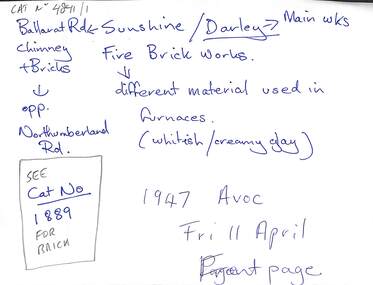
Archive - Sunshine Fire Brick Company, 1940s
... Collection of documents on the Sunshine Fire Brick Company including location map...Sunshine Fire Brick Company Ballarat Road Sunshine Manufacturing Collection of documents on the Sunshine Fire Brick Company including location map Archive Sunshine Fire Brick Company ...sunshine fire brick company, ballarat road, sunshine, manufacturing -
 Federation University Historical Collection
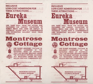
Document - Document - Advertising Cards, ZILLES COLLECTION: Advertising Card for Historic Montrose Cottage and Eureka Museum
... Coat of Arms. Location map....Coat of Arms. Location map. White card with russet colour print. ...Zilles Printers was begun by Lewis Zilles in the early 1930s. It was in McKenzie Street Ballarat. His son Jeffrey also became a printer - letterpress, offset and screen printer. The business became Zilles Printers/Graphics and was in Armstrong Street and later Bell Street Ballarat. Montrose Cottage was build c1856 by John Alexander, builder. He was a Scottish stone mason. It was built with bluestone and hand-made bricks. It is on the Historic Buildings Register, National Trust (Victoria). It is important as a substantial and very early stone cottage. The house is now open to the public. It also provides short term accommodation - self contained apartments. Double sided cards advertising Montrose Cottage and Eureka Museum. Printed by Zilles Graphic Industries, Ballarat. White card with russet colour print. Printed on both sides. Each side has Eureka Museum and Montrose CottageEureka Flag and Cannon. Drawing of Montrose Cottage and flag with Lion. Symbol of National Trust Australia. Coat of Arms. Location map.zilles graphic industries, montrose cottage, eureka musuem -
Lakes Entrance Historical Society
Book, Department of Natural Resources and Environment, Request for Tender - Recreation Earthworks in Colquhoun Forest, 2002
... Tender request for recreation building works in the Colquhoun Forest, especially bridges. Contains a location map...Lakes Entrance Historical Society 4 Marine Parade Lakes Entrance gippsland Recreation Government Tender request for recreation building works in the Colquhoun Forest, especially bridges. Contains a location map Request for Tender - Recreation Earthworks in Colquhoun Forest Book Department of Natural Resources and Environment ...Tender request for recreation building works in the Colquhoun Forest, especially bridges. Contains a location maprecreation, government -
Lakes Entrance Historical Society
Book, Department of Natural Resources and Environment, Request for Tender- Recreation Earthworks in the Colquhoun Forest, 2002
... Tender specifications for recreation earthworks in the Colquhoun Foret, including pathways and drainage. Contains location map....Lakes Entrance Historical Society 4 Marine Parade Lakes Entrance gippsland Government Recreation Tender specifications for recreation earthworks in the Colquhoun Foret, including pathways and drainage. Contains location map. Request for Tender- Recreation Earthworks in the Colquhoun Forest Book Department of Natural Resources and Environment ...Tender specifications for recreation earthworks in the Colquhoun Foret, including pathways and drainage. Contains location map.government, recreation -
 Ringwood and District Historical Society
Map, Partially trimmed copy of a retail and residential auction advertisement, Ringwood, Vic. - 1926
... Bonwick, Licensed Surveyor, Phone WU4830. Location map also includes Bourke Street, Bond Street, Charter Street, Ringwood Street, and Shops and Market sites in Ringwood....Bonwick, Licensed Surveyor, Phone WU4830. Location map also includes Bourke Street, Bond Street, Charter Street, Ringwood Street, and Shops and Market sites in Ringwood. ...One of 3 unrelated land subdivision maps on cardboard backing. Numbered allotments on Nelson Street, Seymour Street and Whitehorse Road, Ringwood.W.J. Bonwick, Licensed Surveyor, Phone WU4830. Location map also includes Bourke Street, Bond Street, Charter Street, Ringwood Street, and Shops and Market sites in Ringwood. -
Lakes Entrance Historical Society
Book, Love Don, Shipwrecks around Port Phillip Heads, 2007
... Well documented stories of the shipwrecks around Port Phillip Heads Victoria 1840-1900 with references photographs location Map and sketches....Lakes Entrance Historical Society 4 Marine Parade Lakes Entrance gippsland Ships and Shipping History Well documented stories of the shipwrecks around Port Phillip Heads Victoria 1840-1900 with references photographs location Map and sketches. Shipwrecks around Port Phillip Heads Book Love Don ...Well documented stories of the shipwrecks around Port Phillip Heads Victoria 1840-1900 with references photographs location Map and sketches.ships and shipping, history -
 Ringwood and District Historical Society
Flyer, Auction - 8 Pembroke Court, Ringwood North, Victoria - 1995
... A4 size advertisement for executor's auction of residential property with site plan and location map. Auction date Saturday 2nd September (1995)....A4 size advertisement for executor's auction of residential property with site plan and location map. Auction date Saturday 2nd September (1995). ...A4 size advertisement for executor's auction of residential property with site plan and location map. Auction date Saturday 2nd September (1995).Outstanding elevated allotment situated in a delightful court surrounded by quality homes. All services available. Land: 1,255 Sq.m. (13,504 Sq.m.) approx. Terms: 10% deposit, balance 60 days. Agent - Sutherland Real Estate, 43 Agnes Street, East Melbourne (Telephone) 9650 3531. -
Glenelg Shire Council Cultural Collection
Document - Flyer - Promotional material for Portland Victoria, n.d
... Textured paper, full colour photographs of Portland and location map....Textured paper, full colour photographs of Portland and location map. Document Flyer - Promotional material for Portland Victoria Becombe Press, Portland ...DL flyer, bi-fold, advertising Portland as a place for industrialists to invest in. Textured paper, full colour photographs of Portland and location map.portland industry -
 Ringwood and District Historical Society
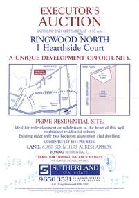
Flyer, Auction - 1 Hearthside Court, Ringwood North, Victoria - 1995
... A4 size advertisement for executor's auction of 1.73 acre property with site plan and location map. Auction date Saturday 2nd September (1995)....A4 size advertisement for executor's auction of 1.73 acre property with site plan and location map. Auction date Saturday 2nd September (1995). ...A4 size advertisement for executor's auction of 1.73 acre property with site plan and location map. Auction date Saturday 2nd September (1995).Prime residential site. Ideal for redevelopment or subdivision in the heart of this well established residential suburb. Existing older style two bedroom aluminium clad dwelling. Currently let $145 per week. Land: 6,980 Sq.m. (1.73 acres) approx. Zoning: Residential C. Terms: 10% deposit, balance 60 days. Agent - Sutherland Real Estate, 43 Agnes Street, East Melbourne (Telephone) 9650 3531. -
 Ringwood and District Historical Society
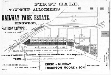
Flyer, Subdivision advertisement - Railway Park Estate, Ringwood, Victoria - circa 1887
... , with terms of sale and location map...., with terms of sale and location map. Subdivision advertisement - Railway Park Estate, Ringwood, Victoria - circa 1887 Flyer ...Photocopy of advertisement for auction sale of township allotments in Railway Park Estate, Ringwood, on Saturday 30th April (1887?), with terms of sale and location map.Subdivision map includes Pitt Street and Main Ferntree Gully Road (later Bedford Road). (Agents) Greig & Murray, Thompson Moore & Son, Auctioneers. -
 Ringwood and District Historical Society
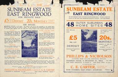
Flyer, Land Sale Advertisement - Sunbeam Estate, East Ringwood, Victoria - circa 1930
... Folded double-sided page advertising private sale of 48 residential allotments, with location map, terms of sale, and details of local features and services. ...Folded double-sided page advertising private sale of 48 residential allotments, with location map, terms of sale, and details of local features and services. ...Folded double-sided page advertising private sale of 48 residential allotments, with location map, terms of sale, and details of local features and services. Locality plan includes Holland Road, Everard Road, Sunbeam Avenue, Mount Dandenong Road, and Lilydale Road (later Old Lilydale Road). (Agents) Phillips & Nicholson, 59 Swanston Street, Melbourne, (Phone) Central 10907, in conjunction with C.E. Carter, Bank Chambers, Main Street, Ringwood, Telephone Ringwood 24.