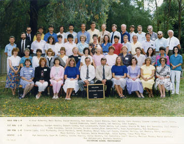
Showing 205 items matching "location of trees"
-
 Friends of Ballarat Botanical Gardens History Group
Work on paper - National Trust of Australia (Vic), Tour of the Ballarat Botanical Gardens 1992-93, 1992-1993
... ...Location of trees...John Garner Doctor John Garner Collection Ballarat Botanical Gardens Trees in the Ballarat Botanical Gardens National Trust of Australia (Vic) Trees in 1992-93 Location of trees Condition of trees Botanic names of trees. ...This listing of trees at this time is important in terms of the subsequent millennial drought and in giving details of where each tree is situated in the Gardens and the condition of each tree.The Ballarat Botanical Gardens has a notable collection of trees, which are important in the history of Ballarat and for citizens and visitors to this City.4 pages printed on both sides, faint though legible grey print. 3 and 1/4 printed pages.Nonejohn garner, doctor, john garner collection, ballarat botanical gardens, trees in the ballarat botanical gardens, national trust of australia (vic), trees in 1992-93, location of trees, condition of trees, botanic names of trees., friends of ballarat botanical gardens, gardens, ballarat -
 Whitehorse Historical Society Inc.
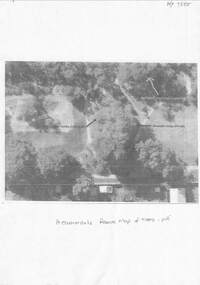
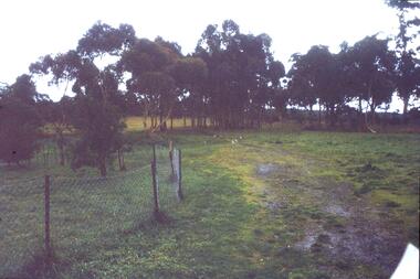
Document - Copy of Aerial photo, The Allen Findlay family and Heatherdale Reserve, unknown
... Shows the location of trees planted by the Findlay family at their farm prior to it becoming part of Heatherdale Reserve....Shows the location of trees planted by the Findlay family at their farm prior to it becoming part of Heatherdale Reserve. ...Shows the location of trees planted by the Findlay family at their farm prior to it becoming part of Heatherdale Reserve.Shows the location of trees planted by the Findlay family at their farm prior to it becoming part of Heatherdale Reserve.non-fictionShows the location of trees planted by the Findlay family at their farm prior to it becoming part of Heatherdale Reserve.findlay family, findlay wilma, scoble wilma, heatherdale reserve -
 Greensborough Historical Society
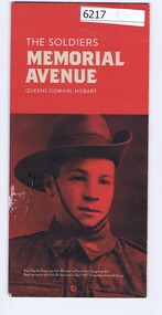
Pamphlet, The Soldiers Memorial Avenue, Queens Domain, Hobart, 2015_
... Includes map, with location of memorial trees....Includes map, with location of memorial trees. war memorials hobart Single sheet printed in colour both sides The Soldiers Memorial Avenue, Queens Domain, Hobart Pamphlet Friends of Soldiers Memorial Avenue Inc ...History, description and maps of the Soldiers Memorial Avenue Hobart. Includes map, with location of memorial trees.Single sheet printed in colour both sideswar memorials, hobart -
 Heidelberg Golf Club
Document - Report, Stephen Fitzgerald Arboriculture, Tree management strategy 2002: Stage 1, 2002=2003
... Stage 1 deals with identification and location of trees and tree groups within HGC boundaries and condition assessment and works recommendations for trees and tree groups in North West area. ...Heidelberg Golf Club 8 Main Road Lower Plenty 3093 Stage 1 deals with identification and location of trees and tree groups within HGC boundaries and condition assessment and works recommendations for trees and tree groups in North West area. ...Stage 1 deals with identification and location of trees and tree groups within HGC boundaries and condition assessment and works recommendations for trees and tree groups in North West area. By Stephen Fitzgerald Arboriculture (Hawthorn East). Includes 3 inserts dated 2024 of plant lists, Banyule planting schemes and significant tree registers.Various paging, maps, illus. Clear cover, metal spiral binding. heidelberg golf club - history, course layout, tree planting, trees -
Glen Eira Historical Society
Map - Caulfield Fire Station, No 26, Tree Reserve, Dandenong Road
... A one page photocopy of an undated, unattributed, hand drawn map (200mm x 290mm) of the location on Tree Reserve, Dandenong Road, of the Caulfield Fire station, No 26. ...Glen Eira Historical Society 965 Glen Huntly Rd Caulfield VIC 3162 melbourne A one page photocopy of an undated, unattributed, hand drawn map (200mm x 290mm) of the location on Tree Reserve, Dandenong Road, of the Caulfield Fire station, No 26. ...A one page photocopy of an undated, unattributed, hand drawn map (200mm x 290mm) of the location on Tree Reserve, Dandenong Road, of the Caulfield Fire station, No 26. The map includes handwritten notes showing various nearby property owners. The file also includes a photocopy of a one page, undated and unattributed printout of the site address and site lease date.caulfield east, caulfield fire station, dandenong road, derby road, racecourse road, tree reserve, shire of caulfield, federal bank, st james building society, delves murchison, fire stations -
 Bendigo Historical Society Inc.
Drawing - Sketch Plans of Avenue of Honour Trees at Bendigo East State School
... The first page shows numbered location of trees and tree species. Page two is a coloured diagram showing where trees are on the site as compared to where the trees have been described by Heritage Victoria. ...The first page shows numbered location of trees and tree species. Page two is a coloured diagram showing where trees are on the site as compared to where the trees have been described by Heritage Victoria. ...Three sheets of paper which contain sketch plans of the Avenue of Honour at Bendigo East State School. The first page shows numbered location of trees and tree species. Page two is a coloured diagram showing where trees are on the site as compared to where the trees have been described by Heritage Victoria. Page three shows a plan of where actual trees and stumps are on site at Bendigo East State School.gemma starr collection, bendigo schools, bendigo east state school, school avenue of honour -
 Bendigo Historical Society Inc.
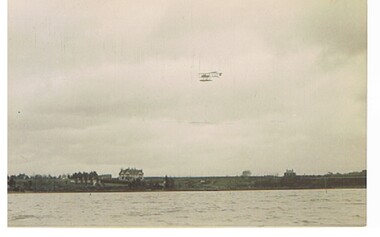
Postcard - BASIL WATSON COLLECTION: POSTCARD, BIPLANE FLYING OVER WATER
... postcard: biplane flying over water, land in background, houses and trees. Location possibly in UK....History House 11 Mackenzie Street Bendigo goldfields AVIATION Civilian biplane BASIL WATSON COLLECTION biplane postcard: biplane flying over water, land in background, houses and trees. Location possibly in UK. Postcard BASIL WATSON COLLECTION: POSTCARD, BIPLANE FLYING OVER WATER ...postcard: biplane flying over water, land in background, houses and trees. Location possibly in UK.aviation, civilian, biplane, basil watson collection, biplane -
 Whitehorse Historical Society Inc.
Photograph, Mullauna Secondary College Staff 1989
... Coloured photograph of staff at Mullauna Secondary College 1989.Photograph taken outdoors in a treed location....Whitehorse Historical Society Inc. 2-10 Deep Creek Road Mitcham melbourne Mitcham technical School, Blackburn Sec college, Donvale High School, later Nunawading High School merged to become Mullauna Secondary College with a $5.2 million government grant 1988.Article on plan to merge at NP3009. mullauna secondary college staff 1989. secondary colleges Coloured photograph of staff at Mullauna Secondary College 1989.Photograph taken outdoors in a treed location. Mullauna Secondary College Staff 1989 Photograph Photograph ...Mitcham technical School, Blackburn Sec college, Donvale High School, later Nunawading High School merged to become Mullauna Secondary College with a $5.2 million government grant 1988.Article on plan to merge at NP3009.Coloured photograph of staff at Mullauna Secondary College 1989.Photograph taken outdoors in a treed location.mullauna secondary college staff 1989. secondary colleges -
 Greensborough Historical Society
Slide - Photograph, John Ramsdale, Rural scene: Slide 17, 1990s
... Photograph shows a rural scene with post and wire fence and trees. Location unknown....Greensborough Historical Society 34A Glenauburn Road Lower Plenty Lower Plenty melbourne Photograph shows a rural scene with post and wire fence and trees. Location unknown. Part of the John Ramsdale collection of slides and audio visual material. rural landscape No caption. ...Photograph shows a rural scene with post and wire fence and trees. Location unknown.Part of the John Ramsdale collection of slides and audio visual material.Colour photograph scanned from slide.No caption. Printed maker's mark on slide "Kodak Kodachrome Slide"rural landscape -
 Bendigo Historical Society Inc.
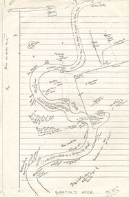
Document - PETER ELLIS COLLECTION: SKETCH OF THE BARFOLD GORGE
... On the sketch is the location of a house, trees, fences, different types of rock, some accessible areas to get down to the river, geological features and water falls....On the sketch is the location of a house, trees, fences, different types of rock, some accessible areas to get down to the river, geological features and water falls. ...Two photocopies of hand-drawn sketch of the Barfold Gorge. On the sketch is the location of a house, trees, fences, different types of rock, some accessible areas to get down to the river, geological features and water falls.place, land, barfold gorge, peter ellis collection, barfold area, mitchell's falls, queen's fall -
 Bendigo Historical Society Inc.
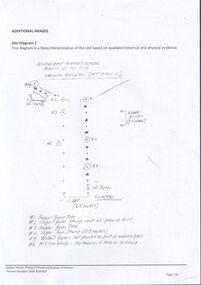
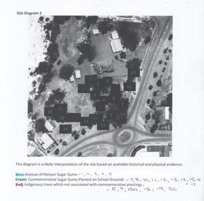
Photograph - Site Diagram of the Bendigo East Primary School
... The sheet of photocopied A4 size paper shows an aerial photograph of the Bendigo East State School and the location of significant trees on school property. The trees have been numbered and colour-coded. ...History House 11 Mackenzie Street Bendigo goldfields Bendigo East State School Bendigo Schools Gemma Starr Collection School Avenue of Honour The sheet of photocopied A4 size paper shows an aerial photograph of the Bendigo East State School and the location of significant trees on school property. The trees have been numbered and colour-coded. ...The sheet of photocopied A4 size paper shows an aerial photograph of the Bendigo East State School and the location of significant trees on school property. The trees have been numbered and colour-coded. Blue: Avenue of Honour Sugar Gums, Green: Commemorative Sugar Gums planted on school grounds. Red: Indigenous trees which are not associated with commemorative plantings. Gemma Starr Collectionbendigo east state school, bendigo schools, gemma starr collection, school avenue of honour -
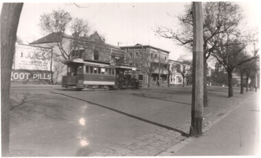 Melbourne Tram Museum
Photograph - Cable tram Nicholson St, Eric Victor Copeman, 21-9-1938
... Note the location of the street trees. Photographer Eric Victor Copeman - based on the handwriting - see also item 8399....Note the location of the street trees. Photographer Eric Victor Copeman - based on the handwriting - see also item 8399. ...The photograph shows a cable tram set, in Nicholson St Fitzroy. Cannot determine the tram number. In the background is an advertisement for Indian Root Pills and a Mr Jones - a Labor candidate. Note the location of the street trees. Photographer Eric Victor Copeman - based on the handwriting - see also item 8399.Yields information about Nicholson St cable tram services.Black and white photograph with notes on the rear.On rear in ink "Nicholson Street, Melbourne Vic (21.9.38) cable tram"tramways, cable trams, nicholson st -
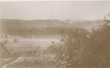 Bendigo Historical Society Inc.
Postcard - ACC LOCK COLLECTION: SEPIA PHOTO OF AN OPEN FIELD AND FOREST, POSTCARD, 1914-1918
... Smoke is seen rising above the trees. Location not known. Handwritten in pencil on the back - G37 and GS...Smoke is seen rising above the trees. Location not known. Handwritten in pencil on the back - G37 and GS Postcard ACC LOCK COLLECTION: SEPIA PHOTO OF AN OPEN FIELD AND FOREST, POSTCARD ...Postcard,WW1, sepia photo of what could have been a battle field with a forest in the background. Smoke is seen rising above the trees. Location not known. Handwritten in pencil on the back - G37 and GSpostcard, ww1, france, battlefield -
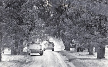 8th/13th Victorian Mounted Rifles Regimental Collection
Photograph
... Black and white photograph of two M 113 Armoured Personnel Carriers in an avenue of large trees. Location unknown but probably taken during 8/13 Victorian Mounted Rifles annual camp 1986....Black and white photograph of two M 113 Armoured Personnel Carriers in an avenue of large trees. Location unknown but probably taken during 8/13 Victorian Mounted Rifles annual camp 1986. ...8/13 Victorian Mounted Rifles was equipped with M113 family of Armoured Fighting Vehicles ( AFVs ) from late 1970s to 1990s.Black and white photograph of two M 113 Armoured Personnel Carriers in an avenue of large trees. Location unknown but probably taken during 8/13 Victorian Mounted Rifles annual camp 1986. -
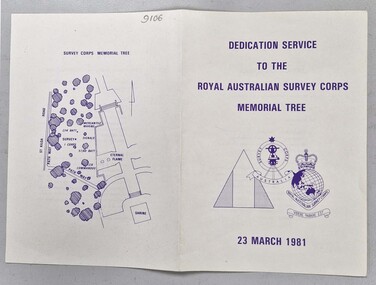 Bendigo Military Museum
Administrative record - Dedication Service Booklet to the RASvy Memorial Tree 1981, Army Survey Regiment, 23 Mar 1981
... Has RASvy tri Badge insignia on the front cover, the Order of Service in the centre and a map on the back showing the location of the RASvy Memorial Tree....Has RASvy tri Badge insignia on the front cover, the Order of Service in the centre and a map on the back showing the location of the RASvy Memorial Tree. Dedication Service Booklet to the RASvy Memorial Tree 1981 Administrative record Dedication Service Booklet to the RASvy Memorial Tree 1981 Army Survey Regiment ...This is the booklet that was prepared for the Dedication service for the RASvy Memorial Tree located in the gardens of the Shrine of Remembrance, Melbourne conducted on 23 March 1981. The service was attended by Colonel NRJ Hillier Director of Military Survey 1978 - 1983 and the address was delivered by Brigadier L Fitzgerald OBE Director of Military Survey 1942-1960. A large number of Survey Corps members and past members were present at the service that was followed by a luncheon.Single page booklet on light buff coloured card printed on both sides and folded in half. Has RASvy tri Badge insignia on the front cover, the Order of Service in the centre and a map on the back showing the location of the RASvy Memorial Tree.royal australian survey corps, rasvy, fortuna, army survey regiment, army svy regt, asr, shrine of remembrance -
 Ballarat Tramway Museum
Document - Photocopy, Alan Bradley, "Car Depot / Wendouree Pde.", 2000
... Drawn at a scale of 1" = 20', shows building layout, track layout, overall dimensions, tree locations, pit details, rooms, paint shop, reduced levels, streets, toilets, steps to pits, tennis court and datum point. ...Drawn at a scale of 1" = 20', shows building layout, track layout, overall dimensions, tree locations, pit details, rooms, paint shop, reduced levels, streets, toilets, steps to pits, tennis court and datum point. ...Set of four A3 size photocopies of a drawing VB4/8709c held by the Public Records Office Victoria of the Ballarat SEC Tramway Depot, dated 5/11/1971, Revision C 22/11/1971. Drawn at a scale of 1" = 20', shows building layout, track layout, overall dimensions, tree locations, pit details, rooms, paint shop, reduced levels, streets, toilets, steps to pits, tennis court and datum point. Drawn after the closure of the tramways, possibly to enable planning for the redevelopment and sale of the property. Drawings copied by Alan Bradley for archives and research.trams, tramways, ballarat, sec, depot, drawings -
 Eltham District Historical Society Inc
Work on paper - Folio, Register of Significant Trees, Shire of Eltham, c.1993
... There is a wide range of indigenous and planted trees on private and public land and extending through the Shire of Eltham from Lower Plenty to Kinglake. Most can be viewed from publicly accessible locations. ...There is a wide range of indigenous and planted trees on private and public land and extending through the Shire of Eltham from Lower Plenty to Kinglake. Most can be viewed from publicly accessible locations. ...In 1983, the National Trust advised the Shire of Eltham that it was investigating a number of trees within the shire which had been nominated for recording the Register of Significant Trees of Victoria. The trees involved were described in the Shire of Eltham Historical Society Newsletter No. 29, March 1983 as follows:- 1. Eucalyptus melliadora (Yellow box) . a) An outstanding mature specimen 42 metres high in Laughing Waters Road, Eltham. b) Another mature specimen in Arthurs Creek road, Hurstbridge is reported to be the tree under which the bushranger Robert Bourke was tied after he shot and killed Henry Hurst in 1866 . 2. Quercus robur (English Oak). a) "Donaldson's Oak", Donaldsons Road, Kangaroo Ground was planted by John Donaldson from seed collected from Windsor Great Park in 1878. b) "Wippells Oak". This now misshapen tree is located on the St. Andrews Road near the Kangaroo Ground Fire Station. Its origins may have been similar to Donaldson's Oak, and as a young tree it apparently slipped from higher up the hill during wet weather. Both oaks are of local historical importance. 3. Eucalyptus globulus (Blue Gum). A large mature specimen at the corner of the Kangaroo Ground-St. Andrews Road and Bakehouse Road, Panton Hill. 4. Plantanas acerifolia (Plane tree) A number of trees forming the Avenue of Honour to Eltham's First World War soldiers along Main Road between Dalton and Pitt Streets, Eltham. 5. Pinus canariensis (Canary Island Pine), Pinus pinea, (Stone pine) and Cedras altlantica, (Cedar) These trees are located at the Hurst family graves in the grounds of the Hurstbridge Pre-school Centre. In 1991 the Shire of Eltham introduced controls into its planning scheme to protect sites of architectural, historic or conservation interest and significant trees. The controls were approved by the Minister for Planning and Housing. As advised in the Shire of Eltham Historical Society Newsletter No. 78, May 1991, a planning permit is required to demolish or alter any listed building or to destroy, lop or remove any listed tree. Provision is made for comments to be obtained from the National Trust or Historic Buildings Council in considering any applications. The buildings and trees listed were: Buildings: 250 Bolton Street Eltham (former Walter Withers home) "Rosehill" - Bonds Road Lower Plenty St Andrews Church of England - St Andrews "Montsalvat" - Hillcrest Avenue Eltham St Margarets Church and former vicarage - Pitt Street Eltham Presbyterian Church - Kangaroo Ground Parks and Environment Office (former police quarters) Main Road Eltham Former Court House - Main Road Eltham "Shillinglaw Cottage" - Main Road Eltham "The Robins" - Kangaroo Ground Road Warrandyte Trees: "Donaldsons Oak" - Donaldsons Road Kangaroo Ground Yellow Box - Laughing Waters Road Eltham Yellow Box - Arthurs Creek Road Hurstbridge Wippells Oak - St Andrews Road Kanqaroo Road Pines and Cedar - Hurst family cemetery Greysharps Road Hurstbridge Yellow Box - Parsons Road Eltham A large Blue Gum at Panton Hill has been listed but has recently died (1991). In 1993 work by Council Parks and Environment staff and volunteers resulted in the preparation of a Significant Tree Register listing forty-one trees or groups of trees. According to Shire of Eltham Historical Society Newsletter No. 91, March 1993, a similar number remained to be assessed for inclusion in the register. There is a wide range of indigenous and planted trees on private and public land and extending through the Shire of Eltham from Lower Plenty to Kinglake. Most can be viewed from publicly accessible locations. The Significant Tree Register lists 41 trees or groups of trees throughout the Shire. It contains a wide range of naturally occurring and planted trees. They have been assessed according to eleven criteria including size, age, rarity, historical value and the like. The list includes large old Red Gums at Lower Plenty, historic Oaks at Kangaroo Ground and Mountain Ash at Kinglake. The register includes a set of slides showing each tree. Garry Bartlett of the Council's Parks and Environment Section and Faye Shepherd were extensively involved in establishment of the register (Newsletter No. 93, November 1993). In 1999 Niliumbik planners prepared an amendment to the Planning Scheme to provide protection for approximately 200 of the places listed in the heritage studies and also in the Significant Tree Register commenced by the Eltham Council (Eltham District Historical Society Newsletter No. 127, July 1999. In 2004, The Register of Significant Trees was presented to the Eltham District Historical Society by Nillumbik Shire Council as part of a wider collection of of its memorabilia of the former Eltham Shire Council (EDHS Newsletter No. 159, July 2004. Album of loose handmade paper sheets contained within a handmade slip cover constructed of handcrafted card with encapsulated flora material (flowers, vines, ferns) and tinted. Each page also contains an embedded/adhered fern leaf also tinted with lacqueur or similar, text as appropriate in ink by hand calligraphy. Each page also has a white protective sheet cut to size and adhered to back surface with sticky tape and folded over face of page. Pages variously have photographs and coloured masks adhered with a gum resin. Over time much of this resin has let go and photos/masks have been reattached using acid free archival safe adhesive. 15 pages 41 x 29 cm inclusive of 3 blank pages. Slip case 42 x 30 x 1 cm; face cover of slip case has broken off at left hand margin as insufficient depth/flexibility for contents.arthurs creek road, blue gum (eucalyptus globulus), canary island pine (pinus canariensis), couties road, donaldsons oak, donaldsons road, eltham, english oak (quercus robur), eucalyptus melliodora, graysharps road, hurst tree, hurstbridge, ironbark (eucalyptus tricarpa), ironbark hill, kangaroo ground, kangaroo ground-kinglake road, laughing waters road, panton hill hotel, panton hill, parsons road, significant trees register, sonia van bodegraven, sonjart, stone pine (pinus pinea). atlantic cedar (cedrus atlantica), wippells oak, yellow box gum (eucalyptus melliodora), yellow box gum -
 Bendigo Military Museum
Album - ALBUM, PHOTOGRAPH WW2
... locations. Album itself is bound loose leaf pages. Cover is pale brown/yellow with picture of lagoon and palm trees on the front and the word " Album" in black. ...locations. Album itself is bound loose leaf pages. Cover is pale brown/yellow with picture of lagoon and palm trees on the front and the word " Album" in black. ...Photos related to 3rd Sqn RAAF WW2. Nature of photo's suggest locations in North Africa and Middle East. The album is related to a collection re E.M. Collihole VX35201, refer Cat No 7235 for his service details.Collection of 60 plus photos in an album. All black and white and the nature is of various landscapes, buildings, people of a local tourist nature around Tripoli and other Middle Eastern/ Arabic looking locations. Album itself is bound loose leaf pages. Cover is pale brown/yellow with picture of lagoon and palm trees on the front and the word " Album" in black. Picture is in green. Two stud holes for binding through which one piece of white string threaded. Other string is missing.Written on inside front cover "Birthday at Farm Killian" and "Mrs Colivers Kid". photos, album, north africa -
 Kiewa Valley Historical Society
Plaque - Eucalypt Chapmanania, 1947
... trees. One at Cranky Charlies and one on the way up to the High Plains passed by the Ryder family on their way up. This plaque was beside the Falls Creek Road and indicated the location of the 'Bogong Gum' tree. ...W.D.Chapman had a keen interest in botany and was particularly interested in Eucalyptus species. He was first to discover the tree which now bears his name on his numerous visits to the Kiewa power station which is situated near the Bogong High Plains. He was a Commissioner and later the Chairman of the State Electricity Commission of Victoria, the organisation in charge of building the Kiewa Hydro Scheme. The tree is a cross between two eucalypts. The trees are unique as they cannot procreate. There were two 'Bogong Gum' trees. One at Cranky Charlies and one on the way up to the High Plains passed by the Ryder family on their way up.This plaque was beside the Falls Creek Road and indicated the location of the 'Bogong Gum' tree. The tree was burnt in the 2003 bush fires but survived only to be killed in the 2006 bush fires. There were two 'Bogong Gum' trees. One at Cranky Charlies and one on the way up to the High Plains passed by the Ryder family on their way up. Heavy bronze plaque embossed with inscription. On the back is a large rectangular steel piece bent at the bottom to form a 'U' shape. One end of the 'u' is attached to the plaque and the other end has two holes for bolts enabling the plaque to be attached near the tree. One bolt is in a hole."Type tree from which was first described the species / Bogong Gum / (Eucalyptus Chapmaniana, Cameron) / The species was identified by the / late Brigadier W. D. Chapman M.C.E., / D. Eng., M.I.E. Aust., M.I.C.E. Lond. Commissioner / of the State Electricity Commission / of Victoria from May 1944 to May 1955, / in his honour it was named."plaque; state electricity commission of victoria; w.d.chapman; eucalyptus; bogong gum tree; falls creek road -
 Kiewa Valley Historical Society
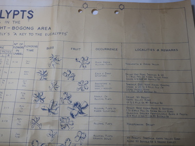
Chart - Eucalypts occurring in the Wangaratta, Bright, Bogong Area
... trees. The last row has the heading "Localities and Remarks" and includes those found around the KHES eg. "Tawonga Gap. West Kiewa. Bogong Creek & up to 5 mile peg on Kiewa Valley Road. 7-12 Mile on Mt Buffalo Rd." Also significant to compare these eucalypts with current locations ...On the 2nd April 1948 the SECV noted the Eucalypts in the area of the Kiewa Hydro Electric Scheme. The Forestry Officer was an employee of the SECV and would have given advice in his area of expertise. This chart may have been used with regard to logging and enabling those involved in the identification of the trees.The last row has the heading "Localities and Remarks" and includes those found around the KHES eg. "Tawonga Gap. West Kiewa. Bogong Creek & up to 5 mile peg on Kiewa Valley Road. 7-12 Mile on Mt Buffalo Rd." Also significant to compare these eucalypts with current locations and numbersLarge chart with black print and pictures on yellowing thick paper. The chart has 18 headings across the top and 24 eucalypts listed under the headings.Printed in the bottom right hand corner "Compiled by W.G. Chandler / Forestry Officer / State Electricity Commission of Victoria / 2-4-48"forestry, w.g.chandler, eucalypts in bogong area -
 Bendigo Military Museum
Photograph - PHOTOGRAPH, FRAMED, possibly between the two World Wars
... Members are wearing puttees & boots. Trees in background. Location unknown. ...Members are wearing puttees & boots. Trees in background. Location unknown. Photograph PHOTOGRAPH, FRAMED Walker Photos Walker Photos ...Black & white photo of unknown battalion with band & instruments in front line. Members are wearing puttees & boots. Trees in background. Location unknown. RHS bottom corner: "Walker Photo"photography-photographs, military history-army -
 Bendigo Military Museum
Honour Board - EAST BENDIGO PRIMARY SCHOOL HONOUR BOARD WW1, original plaques, post WW1
... trees in memory of individual soldiers from the district who had seen active service in WWI. There is evidence that as many as 32 plaques may have been made and affixed (‘the name plaques’). Plaques were removed from their locations...trees in memory of individual soldiers from the district who had seen active service in WWI. There is evidence that as many as 32 plaques may have been made and affixed (‘the name plaques’). Plaques were removed from their locations ...The Bendigo East Primary School was opened in 1915. In 1916 it was decided to plant an ANZAC Avenue of trees and this was completed on 16 June 1916. The plaques were placed after WW1. The school was closed in 1998 and the plaques were relocated to the nearby White Hills Secondary College in Napier Street on this board. In the early 2000's the Honour Board was donated to what is now called the Bendigo Military Museum. One hundred years after planting, later in 2016 the trees were removed in controversial circumstances. On the board 8 never returned, there is 1 x "DCM" winner, 1 x "MC" winner and 1 x "MM" winner. There are 3 x Wright Brothers of which 2 never returned. The plaque states that the soldiers attended the school which is obvious they could not have due to the opening date. The following Heritage report suggests that the names were of individual soldiers who lived in the area. EXTRACT FROM HERITAGE COUNCIL VICTORIA 2016 SUBMISSIONS HEARING “The Bendigo East School (‘the school’) was officially opened by Mr Frank Tate, Director of Education, on 7 April 1916. Approximately two months later, on 16 June 1916, Arbor Day was celebrated at the school with the planting of an ‘Anzac Avenue’ along a path from the front gate on Strickland Road (‘the pathway’) to commemorate the landing of soldiers at Gallipoli. The school’s ‘Anzac Avenue’ was one of an estimated 37 known to have been planted by school children throughout Victoria during mid-1916 as part of a program led by the Education Department, which included a recommendation to schools on 18 May 1916 that commemorative avenues be planted (‘the 1916 plantings recommendation’). At around this time, avenues of honour were also planted across Victoria to commemorate fallen WWI soldiers (‘the wider commemorative plantings phenomenon’). There were other commemorative plantings at the Place away from the pathway (‘the other commemorative plantings’). Anzac Day was celebrated at the Place in the years subsequent to 1916 and on 11 December 1920 the school’s ‘Anzac Avenue’ was officially opened. Embossed copper plates, mounted on wood, were fixed in front of the trees in memory of individual soldiers from the district who had seen active service in WWI. There is evidence that as many as 32 plaques may have been made and affixed (‘the name plaques’). Plaques were removed from their locations at some stage before 1964, mounted on a board and displayed in the school building. These are now located and displayed at Bendigo Sub - Branch of the Returned Services League.” EAST BENDIGO HONOUR BOARD – COPPER PLAQUES (27 PLAQUES in total). 1. 2441 CPL G.V. LE KIM 60th BATT. M.M. (George Vincent LEE-KIM, born in Bendigo, Awarded Military Medal. RTA. NOK Father’s Address: C/- Strickland Rd, Bendigo). 2. 3821 PTE. E.B. HEM 20TH BATT. (Edward Bert Hem born in Bendigo. RTA. NOK Mother’s address: White Hills Post Office). 3. 3513 PTE. C.A. FOLEY 57th BATT. (Charles Albert Foley born in Bendigo. RTA. NOK Father’s address: Wilkie Street, Bendigo). 4. 5241 PTE. G. E. WRIGHT 6th BATT. † (George Edwin Wright born in Bendigo. KIA 8/12/1916. NOK Father’s address: 55 Charleston Rd. Bendigo). 5. 2663 L.CPL. N. E. DAVIS 60th BATT. (Norman Edward Davis born in Footscray. RTA. NOK Mother’s address: 193 Strickland Rd. Bendigo). 6. PTE. A. MOOG 16-6th BATT. † (5143 Adolph Moog born in Bendigo. Died of wounds received in action 8/12/1916, NOK Father’s address: Municipal Yards, Bendigo.) 7. 6515 SGT. W.A. BIRCHMORE DCM 11TH BATT. FIELD ARTILLERY (William Albert Birchmore born in Bendigo. Awarded DCM. RTA. NOK Mother’s address: Butler Street, California Gully) 8. 3924 PTE. J.P. NEWMAN 5TH BATT. † (392 (NAA) James Pausey Newman. Born in Bendigo. KIA 25/7/1916. NOK Father’s address Strickland Road, Bendigo) 9. 4865 PTE. H. T. NUGENT 5TH PIONEER BATT. † (also 4765 Hector Thomas Nugent born in Bendigo. KIA 26/11/1916. NOK Mother’s address: 55 Charleston Rd Bendigo). 10. 835 PTE. C.J. WRIGHT 7TH BATT. † (825(NAA) Charles Julian Wright. Born in Bendigo. KIA at Gallipoli 25/4/1915 NOK Father’s address 55 Charleston Rd Bendigo) 11. 5242 PTE. T.S. WRIGHT M.M. 6TH BATT. (Thomas Stanley Wright born in Bendigo. RTA. NOK Father’s address: 55 Charleston Road, Bendigo). 12. 13111 PTE. R.I. LEE 5TH FIELD AMBCE (19111 Robert Irwin Lee. Born in Kilcunda, Vic. RTA. NOK Wife’s address C/- Barnard Street, Bendigo) 13. 3731 DRIVER T.S. BROWN 5TH BATT.† (Thomas Sheridan Brown born in Bendigo. Died in the Field in France of Heart Failure. NOK Father’s address: Mundy Street, Bendigo). 14. 60999 PTE. J. SPENCE 5th BATT. (John Spence born in Bendigo. RTA. NOK Father’s address: 99 Talbot St, Brunswick) 15. 5127 PTE. S.A. LOY 7TH BATT. (Samuel Arthur John Loy. Born in White Hills, Bendigo. RTA Medical discharge. NOK Wife’s address C/- Hargreaves St Bendigo.) 16. 1649 PTE. A.M. HUTCHINSON 60TH BATT. (Alexander Morton Hutchison. (Note different spelling) born in Bendigo. RTA. NOK Mother’s address Wilkie Street, Bendigo). 17. 3035 PTE. R.J. FLACK 10TH – 7TH BATTs. † (Robert John Flack born in Bendigo. KIA France 17/8/1916. NOK Father’s address: Strickland Road, Bendigo). 18. 4558 PTE. J.J. O’BRIEN 60TH BATT.† (John James O’Brien born in Glenalbyn, Vic. KIA 28/9/1917. NOK Father’s address 68 Strickland Rd. Bendigo). 19. 5233 CPL. G. WHITTING MOTOR TRANSPT. COY. (George Whitting born in White Hills, Bendigo. RTA. NOK Mother’s address: 46 Baxter Street, Bendigo). 20. 5203 PTE. A.J. TATTERSALL 6TH BATTALION (Arthur James Tattersall born in Mandurang, Vic. RTA. NOK Wife’s address “Thornwell”, Bendigo East PO.) 21. 2ND LIEUT. K.G. EMONSON M.C. 38th BATT. (Keith Glanfield Emonson born in Sydney NSW. RTA – Medical discharge/ GSW head. NOK Father’s address: Strickland Road, Bendigo). 22. LIEUT. A.J. HAMPSON RAILWAY UNIT (Alfred John Hampson R/N 2300. Born in Bendigo. RTA. NOK wife’s address: 76 Addison St. Elwood, Vic). 23. 216 SIGNLR R.P. BROWN 38TH BATT † (Raymond Patrick Brown, born in Bendigo. KIA 28 May 1917. NOK. Mother’s address: 138 Mundy Street, Bendigo). 24. 15118 STAFF SGT. A. EMONSON 3RD L. H. F. AMBULANCE (Harry Allen Phipps Emonson born in Sydney NSW. RTA. NOK Father’s address Strickland Road, Bendigo, Vic). 25. 1724 CPL. L.J. CHAPPLE 5TH BATT. (Leslie John Chapple born in Bendigo. RTA. NOK Father’s address: Nolan Street, Bendigo) 26. 4557 PTE. E. O’BRIEN 60TH BATT. (Edward Charles O’ Brien, RTA. (NOK Father’s address: Strickland Rd, Bendigo). 27. 3557 SIGNLER F. H. LYALL 5TH BATT. (Francis Hubert Lyall born in Bendigo. RTA. NOK Father’s address: Strickland Rd, Bendigo). Honour Board, Bendigo East Primary School, timber backing with a white timber edging. At the top is a silver Rising Sun Badge with the dates in white "1914 & 1919". There are 27 bronze plaques, each has the Soldiers Regt Number, Name, Rank and Unit, for those that did not return there is a Cross added, if the Soldier won an award it is also added. At the bottom left hand corner is a brass plaque with details. Refer Aquisition for details. On the brass plaque, “These plaques were placed on the Avenue of trees at the school entrance on 20 December 1920. They were a memorial to those who enlisted from the Bendigo East School in the 1914 - 18 War. Mr R. J. Lee a Returned Soldier was Principal at this time”memorials-honour boards, military history-service records, metalcraft-bronze, east bendigo -
 Kiewa Valley Historical Society
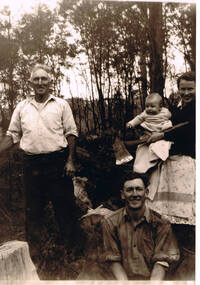
Photograph of Kiewa Valley Pioneer Family, Three Generations of Kiewa Valley Pioneer Family (Coopers), late 1900s'
... trees for land clearing, building sheds and fences, outhouses and fire wood. This photograph was taken during a time where both male and females did some heavy lifting and processing. The rural sector at this point in time was physically a hard location...trees for land clearing, building sheds and fences, outhouses and fire wood. This photograph was taken during a time where both male and females did some heavy lifting and processing. The rural sector at this point in time was physically a hard location ...This historical family photograph spans three generations of the Cooper Family, a pioneer family, still residing in the Kiewa Valley. The large axe held by Pat was a handy tool for pioneer families to chop down trees for land clearing, building sheds and fences, outhouses and fire wood. This photograph was taken during a time where both male and females did some heavy lifting and processing. The rural sector at this point in time was physically a hard location for both sexes. The segregation of the sexes into specific job categories was some times non existent although household "chores" was in the main a woman's domain. The rural sector was in this point of time one which women were highly respected and the unwritten law of providing "assistance" and "reverence" by men in such actions as, socially opening doors, tipping the cap, offering a sturdy arm for support and refraining from doing or saying anything "uncouth" in a woman's presence. It was in a time when women's liberation was just starting to grow strength. Rural areas, on the hole, took longer to interfuse "city" hatched norms of behaviour. This photograph of a pioneer family still residing in the Kiewa Valley demonstrates not only the close protective environment that the valley has on all its inhabitants but also the close bonding that neighbors have towards each other. The term "God's gifted country" fits warmly with all the settlements in the valley. The relatively isolated (physically, visually and communications wise) has since post World War II been whittled away by faster and vastly improved communications with "the outside" world. The strength of commitment to the rural life can be seen in the faces of the family members in this photograph. The proud heritage is displayed without any external pressure. This large black and white family photograph is a reproduction on Fujicolor Crystal Archive Paper manufactured by Fujifilm. It is 200gsm matt finished paper with no borders. On the reverse side, written in pencil "Ted Cooper sitting aged 24-25, Pat Amery (Ted's youngest sister) holding Ted's eldest son Doug and Ted's father John Franklin Cooper(22-8-1892)"john cooper, ted cooper, pat amery, doug cooper, pioneer family kiewa valley -
 Kiewa Valley Historical Society
Meter Ammeter Recorder, Circa 1950
... locations would cover the North East regions of Victoria. They cover voltage drops at domestic and business properties especially those that were experiencing regular fluctuations(daily) at approximately the same time of the day. As the electrical network is required to operate within a set level of voltage, fluctuations outside of this has to be investigated and necessary remedial action taken. This is especially so for rural properties where power "drainage" can occur through animal/bird and tree...locations would cover the North East regions of Victoria. They cover voltage drops at domestic and business properties especially those that were experiencing regular fluctuations(daily) at approximately the same time of the day. As the electrical network is required to operate within a set level of voltage, fluctuations outside of this has to be investigated and necessary remedial action taken. This is especially so for rural properties where power "drainage" can occur through animal/bird and tree ...This testing voltmeter recorder was last certified by SEC Vic laboratories on the 17/4/77. It was used extensively as mobile recorder placed for periods of one month at locations experiencing unacceptable fluctuations of power. These locations would cover the North East regions of Victoria. They cover voltage drops at domestic and business properties especially those that were experiencing regular fluctuations(daily) at approximately the same time of the day. As the electrical network is required to operate within a set level of voltage, fluctuations outside of this has to be investigated and necessary remedial action taken. This is especially so for rural properties where power "drainage" can occur through animal/bird and tree interference. It can also be the result of defective wiring and overloading at peek operational times (milking machines).This mobile voltage recorder is very significant to the Kiewa Valley because it highlights the difficulties that can occur in maintaining a power supply that experiences fluctuating power demands by the rural industries that it supplies. The requirement of a mobile testing apparatus to cover the various sections in the Kiewa Valley and other rural areas in the northeast region is one of necessity as electricity once connected to a rural property is a labour saving supply as generators on rural properties require a higher degree of maintenance an ultimately at a higher cost. The testing of the SEC Vic supplied electricity to rural properties,those who had previously run on generators, had to be quick and unassuming with certainty of correct supply levels.The mechanism of this voltage recorder has been installed(by the manufacturer) into its own protective wooden box. This box has a front (swing open) lockable section which permits direct access to the installed measuring equipment (for servicing and data collection). The top section of the box has two screw on terminals for access to the machine being tested. This tester has its own inbuilt ink supply facilities and a mechanical clockwork device that unwinds a roll of paper onto a second roll at a rate of 10 mm per hour. The recording chart is marked with time slots against voltage. There is a recording arm which has an ink pen at the end. Both arm and pen carry the ink supply from the ink reservoir, located on the left side of the cabinet door in specially constructed bottle holder( three small bottle capacity). To record a suspect power problem to a home or business establishment the voltmeter is connected to a power supply outlet being tested and wind the recording clockwork mechanism (gives a four week running time). Before leaving the recorder in situ the electrician checks to see if the chart is recording the correct voltage and that the clock mechanism is advancing correctly.On the front of the access "door" at the top a metal label "RECORDING AMMETER" below this "MURDAY SYSTEM" below this "ALTERNATING CURRENT" and below this the manufacturer's registered number "No. 139156" Below this is a metal tag with State Electricity Commission of Victoria Electrical Engineer's Section equipment number "338" Below these tags and above the viewing window is the manufacturer's dtails "EVERSHED & VIGNOLES Led LONDON"sec vic kiewa hydro scheme, alternate energy supplies, alpine feasibility studies temperature, rainfall, power outages -
 Kiewa Valley Historical Society
Case Volt Meter Recorder, Circa 1950 to 1977
... locations would cover the North East regions of Victoria. They cover voltage drops at domestic and business properties especially those that were experiencing regular fluctuations(daily) at approximately the same time of the day. As the electrical network is required to operate within a set level of voltage, fluctuations outside of this has to be investigated and necessary remedial action taken. This is especially so for rural properties where power "drainage" can occur through animal/bird and tree...locations would cover the North East regions of Victoria. They cover voltage drops at domestic and business properties especially those that were experiencing regular fluctuations(daily) at approximately the same time of the day. As the electrical network is required to operate within a set level of voltage, fluctuations outside of this has to be investigated and necessary remedial action taken. This is especially so for rural properties where power "drainage" can occur through animal/bird and tree ...This case is for a testing voltmeter recorder. The last time it was certified by SEC Vic laboratories on the 17/4/77. It was used extensively in the transportation of the mobile recorder which was sometimes placed for periods of one month at locations experiencing unacceptable fluctuations of power. These locations would cover the North East regions of Victoria. They cover voltage drops at domestic and business properties especially those that were experiencing regular fluctuations(daily) at approximately the same time of the day. As the electrical network is required to operate within a set level of voltage, fluctuations outside of this has to be investigated and necessary remedial action taken. This is especially so for rural properties where power "drainage" can occur through animal/bird and tree interference. See KVHS 0302 (A) for the instrument.This case for a mobile voltage recorder is very significant to the Kiewa Valley because it highlights the difficulties that can occur in maintaining a power supply that experiences fluctuating power demands by the rural industries that it supplies. The requirement of a mobile testing apparatus to cover the various sections in the Kiewa Valley and other rural areas in the northeast region is one of necessity as electricity once connected to a rural property is a labour saving supply as generators on rural properties require a higher degree of maintenance an ultimately at a higher cost. The testing of the SEC Vic supplied electricity to rural properties,those who had previously run on generators, had to be quick and unassuming with certainty of correct supply levels.This heavy and thick all leather case for the "easy" transportation of the Volt meter recorder has a opening top which pop riveted to the main body(rivets are aluminium). The all leather top has a shaped carrying handle which is also riveted on. There are two straps on the side of the top which can be fastened to the main body by metal "shoe" buckles. The bottom end is secured to the main bag by large rivets.Tick grade stitching is on all corners.Nilsec vic kiewa hydro scheme, alternate energy supplies, alpine growth in electricity consumption -
 Emerald Museum & Nobelius Heritage Park
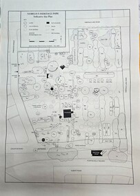
Map - Map of Nobelius Heritage Park - 2003, Nobelius Heritage Park, Indicative Site Plan - drawn November 2003, c2003
... Emerald Museum & Nobelius Heritage Park 5 Crichton Rd Emerald yarra-valley-and-the-dandenong-ranges Laid out plan of Nobelius Heritage Park dated 2003, showing locations of trees and plants Nobelius Heritage Park, indicative site plan (Legend)/locations of tress/plants on the site Image of Indicative Site Plan of Nobelius Heritage Park Nobelius Heritage Park, Indicative Site Plan - drawn November 2003 Map Map of Nobelius Heritage Park - 2003 ...Laid out plan of Nobelius Heritage Park dated 2003, showing locations of trees and plantsImage of Indicative Site Plan of Nobelius Heritage ParkLaid out plan of Nobelius Heritage Park dated 2003, showing locations of trees and plants -
 Emerald Museum & Nobelius Heritage Park
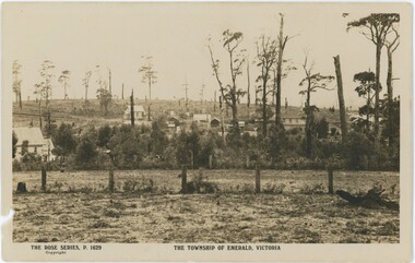
Postcard, Rose Stereograph Company, The Township of Emerald, Victoria, c. 1920s-30s
... This postcard displays a sepia photograph with agricultural space - a field, fences, and trees - in the foreground, and a collection of buildings on a road rising on a hill in the background. Printed text below the image introduce the series and location, while the reverse features a medium-sized rose (a midpoint in the evolution of Rose postcards) and printed text but no message written....Rose Series Emerald Obverse: Bottom Left: "THE ROSE SERIES, P. 1629 / Copyright" Bottom Center: "THE TOWNSHIP OF EMERALD, VICTORIA" Reverse: Printed, Top: "REAL PHOTO POST CARD / THE "ROSE" SERIES DE LUXE PRODUCED IN AUSTRALIA" Printed, Left Side: "PUBLISHED BY 'THE ROSE STEREOGRAPHS' / Armadale, Victoria" Handwritten, Center-Left: "NOT EMERALD / - KEVIN HOGAN / - GWEN ASLING / - KEVIN TEASDALE / - CHRIS BRITTON" Handwritten, Stamp Box: "$12" This postcard displays a sepia photograph with agricultural space - a field, fences, and trees - in the foreground, and a collection of buildings on a road rising on a hill in the background. Printed text below the image introduce the series and location, while the reverse features a medium-sized rose (a midpoint in the evolution of Rose postcards) and printed text but no message written. ...The handwritten names on the reverse of this postcard - Kevin Hogan, Gwen Asling, Kevin Teasdale, and Chris Britton - are all individuals associated with the museum (to varying degrees), seemingly confirming their assessment that this postcard is mistitled and its image is not in fact of Emerald. They were likely correct, indicating that Rose Stereography may have made a mistake. It is difficult to determine how unusual this was; Rose made more than ten thousand postcards, so it is entirely possible some were not checked sufficiently. The reference number P. 1629 was reused at least two more times.While the image on this postcard may not actually be of Emerald, the fact that it is mislabeled as such still tells us about the perception of Emerald at the time of publication - that of a growing rural town amidst hills and trees.This postcard displays a sepia photograph with agricultural space - a field, fences, and trees - in the foreground, and a collection of buildings on a road rising on a hill in the background. Printed text below the image introduce the series and location, while the reverse features a medium-sized rose (a midpoint in the evolution of Rose postcards) and printed text but no message written.Obverse: Bottom Left: "THE ROSE SERIES, P. 1629 / Copyright" Bottom Center: "THE TOWNSHIP OF EMERALD, VICTORIA" Reverse: Printed, Top: "REAL PHOTO POST CARD / THE "ROSE" SERIES DE LUXE PRODUCED IN AUSTRALIA" Printed, Left Side: "PUBLISHED BY 'THE ROSE STEREOGRAPHS' / Armadale, Victoria" Handwritten, Center-Left: "NOT EMERALD / - KEVIN HOGAN / - GWEN ASLING / - KEVIN TEASDALE / - CHRIS BRITTON" Handwritten, Stamp Box: "$12"rose series, emerald -
4th/19th Prince of Wales's Light Horse Regiment Unit History Room
Order of Ceremony, The Royal Australian Amored (sic) Corps the Keeffe Family & Eoghan McDonald Celebrates (sic) the Unveiling of a Commemorative Plaque 16 November 2014, 2014
... tree. The tank straightened and appeared to be well under control, suddenly the bank on the left collapsed to the extent of 3ft by 12ft by15ft long causing the vehicle to slide into the creek and turn upside down." Captain Pearson and Sergeant Ball were faced with a nightmarish situation: The Grant had come to rest upside down in soft mud, six crew members were unaccounted for, escape hatches could not be opened and the weight of the tank was settling deeper into the water and mud. Compounding the problem was that the location...tree. The tank straightened and appeared to be well under control, suddenly the bank on the left collapsed to the extent of 3ft by 12ft by15ft long causing the vehicle to slide into the creek and turn upside down." Captain Pearson and Sergeant Ball were faced with a nightmarish situation: The Grant had come to rest upside down in soft mud, six crew members were unaccounted for, escape hatches could not be opened and the weight of the tank was settling deeper into the water and mud. Compounding the problem was that the location ...The 13th Australian Armoured Regiment was a Gippsland militia unit that had been called up for full time duty in December 1941 as a traditional light horse regiment. The early months of 1942 had seen the regiment lose its horses, a conversion to a motor regiment and finally to an armoured regiment in May. During this period there were considerable changes in personnel, however the regiment maintained its strong links to Gippsland and its former identity. Between May and November 1942, individual soldiers had become proficient in their trade training and the regiment changed its focus to troop and squadron activities. On 16 November 1942, the unit was located at the Puckapunyal Army Camp. C Squadron's training program involved a night driving exercise where a column of armoured and B vehicles would depart camp at 0245 hours and proceed to a site to the East of Seymour and set up a bivouac between Whiteheads Creek and Highlands Road. Numerous army camps surrounded the Seymour area; and much of the surrounding farm land had been acquired for military purposes. By November 1942 exercises such as C Squadron's were commonplace and had been repeated on numerous occasions since 1939. At 0400 hrs, C Squadron's vehicles reached O'Sullivan's Paddock on the Kobyboyn Road; prior to reaching the Old Telegraph Road the column turned to the North towards a known crossing point on Whiteheads Creek. The column consisted of seven M3 Medium Tanks and four Universal Carriers. In the case of Corporal McLeod's vehicle, there were seven crewmen rather than the usual five man crew. On arrival at the creek crossing, Captain C.M.I. 'Sandy' Pearson dismounted and with the assistance of Sergeant R.J. Ball began to guide individual tanks across the creek. Four tanks had crossed the creek without difficulty when Corporal McLeod's tank, ARN 24652, began its descent. Captain Pearson stated at the Coroner's Inquiry in December 1942, "Whilst climbing out of the ford the vehicle swerved to the left, apparently striking the tree. It was not the portion of the tank (front) that struck the tree. The tank straightened and appeared to be well under control, suddenly the bank on the left collapsed to the extent of 3ft by 12ft by15ft long causing the vehicle to slide into the creek and turn upside down." Captain Pearson and Sergeant Ball were faced with a nightmarish situation: The Grant had come to rest upside down in soft mud, six crew members were unaccounted for, escape hatches could not be opened and the weight of the tank was settling deeper into the water and mud. Compounding the problem was that the location of the tank did not allow for the other tanks to safely conduct a recovery. It was truly the darkest night.Single A4 card. folded, Contains an account of the raising of 13 Armoured Regiment in December 1941and a tank accident during a night creek crossing in which six crewmen were killed, and, Order of Ceremony for plaque unveiling, Guest of Honour LtCol Stuart Cree CO/CI School of Armour13 armored regiment, tank accident, puckapunyal -
 Federation University Historical Collection
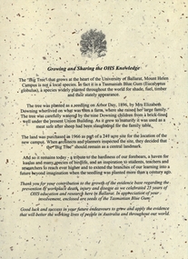
Document - Document - Letter, VIOSH: University of Ballarat; "Growing and Sharing the OHS Knowledge" - 25 years Celebration, 2004
... Tree" at the heart of the University of Ballarat, Mount Helen. The seedling was planted in 1896 by Mrs Elizabeth Downing who lived on what was their farm. The land was purchased in 1966 as part of a site for the location...Tree" at the heart of the University of Ballarat, Mount Helen. The seedling was planted in 1896 by Mrs Elizabeth Downing who lived on what was their farm. The land was purchased in 1966 as part of a site for the location ...Victorian Institute of Occupational Safety and Health (VIOSH) Australia is the Asia-Pacific centre for teaching and research in occupational health and safety (OHS) and is known as one of Australia's leaders on the field. VIOSH has a global reputation for its innovative approach within the field of OHS management. VIOSH had its first intake of students in 1979. At that time the Institution was known as the Ballarat College of Advanced Education. In 1990 it became known as Ballarat University College, then in 1994 as University of Ballarat. It was 2014 that it became Federation University. VIOSH Australia students are safety managers, senior advisors and experienced OHS professionals. They come from all over Australia and industry. Students are taught active research and enquiry; rather than textbook learning and a one-size fits all approach. VIOSH accepts people into the Graduate Diploma of Occupational Hazard Management who have no undergraduate degree - on the basis of extensive work experience and knowledge. Letter gives the history of the "Big Tree" at the heart of the University of Ballarat, Mount Helen. The seedling was planted in 1896 by Mrs Elizabeth Downing who lived on what was their farm. The land was purchased in 1966 as part of a site for the location of the new campus It was decided that the tree should remain as a central landmark.Letter typed on cream flecked paper - A4 size. Image of tree A4 card, folded into three, deep burgundy. Letter attached with small packet of seeds. These have been removed.viosh, victorian institute of occupational safety and health, university of ballarat, mount helen, big tree, elizabeth downing, 1896, 1966 -
 Eltham District Historical Society Inc
Photograph - Colour Print, Janefield, Bundoora, c.1982
... location of three remnant farm houses of the 1800s. The Brock House being the main one. Peter has been unable to find any photos of the Brock House, which what built in the late 1850s, severely burnt in the 1930s and demolished in the mid 1960s. The tree...location of three remnant farm houses of the 1800s. The Brock House being the main one. Peter has been unable to find any photos of the Brock House, which what built in the late 1850s, severely burnt in the 1930s and demolished in the mid 1960s. The tree ...The photo encompasses what is present-day University Hill shopping complex and the Janefield Wetlands. Plenty Road is just visible to the left of the photo. Janefield was an area 18 km north-east of central Melbourne that is now part of Bundoora. In 1842 a flour mill, powered by the Plenty River, was built at Janefield, although the locality was not known by that name at that time. It seems that the name Springfield was used in the late 1840s, after a Springfield homestead, and this was changed to Janefield possibly upon the death of Jane Brock in 1847. She was the wife of James Brock, a local landowner and son of the purchaser of the flour mill. This photo is not strictly within the area of interest for EDHS but overlaps do occur at times with other Society’s interests through families and other associated connections. Eltham District Historical Society member (and Greensborough Historical Society member), Peter Van Eeken was undertaking research into this photo and approached the Local History Librarian at Yarra Plenty Regional Library to enquire about digitising the large print copy to facilitate research. Approaches were made to EDHS who had suitable facilities and were willing to accommodate and all parties agreed to add the image as part of their respective collections in partnership. Michael Lanigan, started work as a message boy at Mont Park when he left school at age 14. He worked his way up the system to become farm manager at Mont Park and Janefield Special School. He was one of the last people to drive a herd of cattle (in 1964) between the two locations along Plenty Road. He retired when the school closed around 1993. Mick pointed out the location of three remnant farm houses of the 1800s. The Brock House being the main one. Peter has been unable to find any photos of the Brock House, which what built in the late 1850s, severely burnt in the 1930s and demolished in the mid 1960s. The tree plantation along Plenty Road was established in 1930 and cut down in the mid 1980s. The Victorian Government established tree plantations at about 350 schools in the early 1930s. Briar Hill School had one but Peter is not sure about any other local schools having a tree plantation. Mick informed Peter that it was his job to remove the 14 acres of pine tree roots, after the trees were cut down (due to old age and an infestation of sap sucking insects). For Mick, this was an impossible job, so he arranged a contract, to house all the soil removed from works associated with the construction of the Greensborough Bypass, which needed temporary storage as it was too valuable, and would be great for use in road construction. The contract to store the soil was important to Mick, as the contract stipulated that when the soil was eventually removed, the tree roots had to be removed too. Which got rid of Mick's headache. Apparently, the huge mound of soil that covered the roots in the late 1980s could be seen from Briar Hill. Based on this, the photo is most likely to have been taken 1982 or 1983. The key to a final date is working out when the Board of Works Office opened but so far no information has come to light. (It was purchased by La Trobe University in 1991). The Office existed, or is hinted at, in the photo at the extreme north of the photo, opposite McKimmies Road, on the eastern side of Plenty Road. Photo on loan from Michael Lanigan via Peter Van Eeken. He cannot recall why it was taken. brock family, janefield, janefield drive, janefield wetlands, plenty road, university hill