Showing 50 items matching "long gully creek"
-
 Bendigo Historical Society Inc.
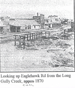
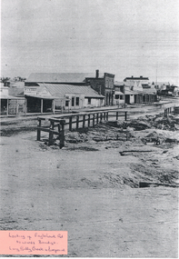
Photograph - LONG GULLY HISTORY GROUP COLLECTION: EAGLEHAWK ROAD FROM THE LONG GULLY CREEK
... LONG GULLY HISTORY GROUP COLLECTION: EAGLEHAWK ROAD FROM THE LONG GULLY CREEK...long gully history group...The Long Gully History Group - Eaglehawk Road from the Long Gully Creek circa 1870...Photocopy of a photo with printing at the bottom: Looking up Eaglehawk Rd from the Long Gully Creek, circa 1870. The photo has buildings along the left of the road and in the foreground is a timber railing at the edge of a creek....History House 11 Mackenzie Street Bendigo goldfields BENDIGO History long gully history group The Long Gully History Group - Eaglehawk Road from the Long Gully Creek circa 1870 Photocopy of a photo with printing at the bottom: Looking up Eaglehawk Rd from the Long Gully Creek, circa 1870. ...Photocopy of a photo with printing at the bottom: Looking up Eaglehawk Rd from the Long Gully Creek, circa 1870. The photo has buildings along the left of the road and in the foreground is a timber railing at the edge of a creek.bendigo, history, long gully history group, the long gully history group - eaglehawk road from the long gully creek circa 1870 -
 Eltham District Historical Society Inc
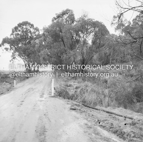
Photograph, Long Gully and environs, Watsons Creek catchment, 23 March 1981, 23/03/1981
... Long Gully and environs, Watsons Creek catchment, 23 March 1981...Long Gully...Watsons Creek...Eltham District Historical Society Inc 728 Main Rd Eltham melbourne Long Gully Watsons Creek Three colour photographs Long Gully and environs, Watsons Creek catchment, 23 March 1981 Photograph ...Three colour photographslong gully, watsons creek -
 Eltham District Historical Society Inc
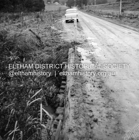
Photograph, Long Gully and environs, Watsons Creek catchment, c.Oct 1982, 1982
... Long Gully and environs, Watsons Creek catchment, c.Oct 1982...long gully...watsons creek...Not shown is Rod Roscholler. 1982 long gully watsons creek lodi francesconi russell yeoman Colour photograph Long Gully and environs, Watsons Creek catchment, c.Oct 1982 Photograph ...Looking for a route for a walking trail from Kinglake to the Yarra River. Not shown is Rod Roscholler. Colour photograph1982, long gully, watsons creek, lodi francesconi, russell yeoman -
 Eltham District Historical Society Inc
Photograph, Long Gully and environs, Watsons Creek catchment, c.Oct 1982, 1982
... Long Gully and environs, Watsons Creek catchment, c.Oct 1982...long gully...watsons creek...Eltham District Historical Society Inc 728 Main Rd Eltham melbourne 1982 long gully watsons creek Colour photograph Long Gully and environs, Watsons Creek catchment, c.Oct 1982 Photograph ...Colour photograph1982, long gully, watsons creek -
 Bendigo Historical Society Inc.
Photograph - LONG GULLY HISTORY GROUP COLLECTION: EAGLEHAWK ROAD
... long gully history group...The Long Gully History Group - Eaglehawk Road...Long Gully Creek...Written on a sticker on the photo is: Looking up Eaglehawk Rd towards Bendigo. Long Gully Creek in foreground....History House 11 Mackenzie Street Bendigo goldfields BENDIGO History long gully history group The Long Gully History Group - Eaglehawk Road Long Gully Creek Dr J Sibley Commercial Two copies of a black and white photo of Eaglehawk Road. ...Two copies of a black and white photo of Eaglehawk Road. Photo shows businesses along the left side of the road. One is a Dr J Sibley and the other the Commercial (last word is very blurry). In the centre of the picture is a short railing fence. The foreground is bare with a culvert on the right. Written on a sticker on the photo is: Looking up Eaglehawk Rd towards Bendigo. Long Gully Creek in foreground.bendigo, history, long gully history group, the long gully history group - eaglehawk road, long gully creek, dr j sibley, commercial -
 Eltham District Historical Society Inc
Album - Photograph Album, J.A. McDonald, Bridge and Road Reconstruction Works, Shire of Eltham, 1952-1962
... ...Long Gully Creek...Creek Road Infrastructure J. Jolly Kangaroo Ground Kangaroo Ground-Queenstown Road Kangaroo Ground-St Andrews Road Lilydale Shire Office Long Gully Bridge Long Gully Creek Long Gully Road Long Gully Lower Plenty Bridge Lower Plenty Footbridge Lower Plenty Oval Lower Plenty Road Lower Plenty Main Road Methodist Church Montmorency Mount Pleasant Road New Holland Old Healesville Road Opening Ceremony Oxley Bridge Para Road Paul Creek Bridge Paul Creek Road Paul Krafeznk Pinnacle Lane Plaques Plenty River Trail Plenty River Presbyterian Church Prof Donald Thomson Pryor Street railway crossing Railway Parade Rattray Road Reconstruction works Reichelt Avenue Research (Vic.) ...J.A. McDonald produced this record in the course of his responsibilities as Shire Engineer for Eltham Shire Council.Record of various Shire of Eltham infrastructure works undertaken during the period of 1952-1962 involving bridge and road reconstruction projects, sometimes with Eltham Shire Council Project Reference numbers quoted. It was during this period that a number of significant improvements were made to roads and new bridges constructed within the shire that remain in place as of present day (2022). In many situations, the photos provide a tangible visible record of infrastructure that existed throughout the early days of the Shire. The album was put together by or under the direction of the Shire Engineer, J.A. McDonald.a. gillies, alistair knox park, benchmark studies, bend of islands, blease road, box hill state school, box hill teachers college, box hill tip, bridge construction, bridge street bridge, bridge, brisbane street, brougham steet, bulldozer, cecil street, charis pelling, cherry tree road, city of preston, cr. a. brinkkotter, cr. charis pelling, cranes, cromwell street, diamond creek (creek), diamond street, dixons creek bridge, dixon's creek road, drott, eltham leisure centre, eltham north, eltham police station, eltham, eltham-yarra glen road, f. wood, fitzsimons lane bridge, flat rock road, flood damage, floods, floodwater, footpaths and gutters, ford service garage, g. blair, garden hill, glen park bridge, glenauburn road, grand hotel, haldane road, healesville, healesville-yarra glen road, heidelberg-kinglake road, henley road bridge, henley road, hill property, hurstbridge water scheme, hurstbridge, hurstbridge-arthurs creek road, infrastructure, j. jolly, kangaroo ground, kangaroo ground-queenstown road, kangaroo ground-st andrews road, lilydale shire office, long gully bridge, long gully creek, long gully road, long gully, lower plenty bridge, lower plenty footbridge, lower plenty oval, lower plenty road, lower plenty, main road, methodist church, montmorency, mount pleasant road, new holland, old healesville road, opening ceremony, oxley bridge, para road, paul creek bridge, paul creek road, paul krafeznk, pinnacle lane, plaques, plenty river trail, plenty river, presbyterian church, prof donald thomson, pryor street, railway crossing, railway parade, rattray road, reconstruction works, reichelt avenue, research (vic.), research oval, road construction, rymers corner, shire of eltham, shire of whittlesea, silvan road bridge, silver street bridge, silver street, sir dallas brooks, smedley property, st andrews, steels creek, susan street, tarrawarra, tony carberry, uniting church, upper yarra dam, upper yarra reservoir, w.e. wolf, waterfall property, watsons creek, wattletree road bridge, wattletree road, wattletree road bridge, worlingworth, yarra glen, york street, yow yow creek -
 Eltham District Historical Society Inc
Negative - Photograph, J.A. McDonald, Healesville-Yarra Glen Road, c.1957
... Long Gully...Healesville...Long Gully Creek...Infrastructure shire of eltham bridge construction Healesville-Yarra Glen Road 1957 Long Gully Healesville Long Gully Creek Old Healesville Road Jackson & Dethridge New Zealand Insurance Co. ...Bridge over Long GullyRecord of various Shire of Eltham infrastructure works undertaken during the period of 1952-1962 involving bridge and road reconstruction projects, sometimes with Eltham Shire Council Project Reference numbers quoted. It was during this period that a number of significant improvements were made to roads and new bridges constructed within the shire that remain in place as of present day (2022). In many situations, the photos provide a tangible visible record of infrastructure that existed throughout the early days of the Shire. The album was put together by or under the direction of the Shire Engineer, J.A. McDonald.infrastructure, shire of eltham, bridge construction, healesville-yarra glen road, 1957, long gully, healesville, long gully creek, old healesville road, jackson & dethridge, new zealand insurance co. ltd., public risk claim -
 Bendigo Historical Society Inc.
Newspaper - JENNY FOLEY COLLECTION: EARLY VIEW
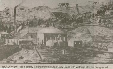
... Early view: Rae's battery looking from the Long Gully Creek with Victoria Hill in the background. ...Early view: Rae's battery looking from the Long Gully Creek with Victoria Hill in the background. ...Bendigo Advertiser ''The way we were'' from 2000. Early view: Rae's battery looking from the Long Gully Creek with Victoria Hill in the background. The clip is in a folder.newspaper, bendigo advertiser, the way we were -
 Bendigo Historical Society Inc.
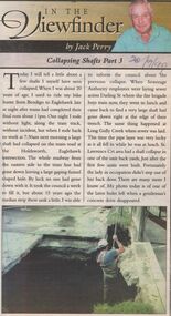
Newspaper - JACK PERRY COLLECTION: NEWSPAPER COLLAPSING SHAFTS IN MINES
... Mentions Holdsworth, Eaglehawk Rd. intersection., Darling Street, Long Gully Creek, St. Lawrence Crt. Subsidences. ...Mentions Holdsworth, Eaglehawk Rd. intersection., Darling Street, Long Gully Creek, St. Lawrence Crt. Subsidences. ...Newspaper article re collapsing shafts. Mentions Holdsworth, Eaglehawk Rd. intersection., Darling Street, Long Gully Creek, St. Lawrence Crt. Subsidences. Bendigo Bendigo Weekly 20.9.99person, individual, jack perry -
 Bendigo Historical Society Inc.
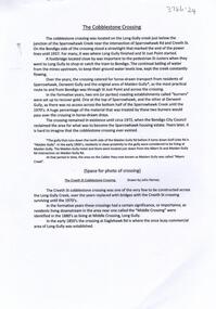
Document - The Cobblestone Crossing, 2/11/2023
... A cobblestone crossing was established across Long Gully Creek near current Creeth Street. The crossing provided horse-drawn vehicles from Sparrowhawk, Derwent Gully and the original Maiden Gully to Long Gully....History House 11 Mackenzie Street Bendigo goldfields A cobblestone crossing was established across Long Gully Creek near current Creeth Street. The crossing provided horse-drawn vehicles from Sparrowhawk, Derwent Gully and the original Maiden Gully to Long Gully. ...A cobblestone crossing was established across Long Gully Creek near current Creeth Street. The crossing provided horse-drawn vehicles from Sparrowhawk, Derwent Gully and the original Maiden Gully to Long Gully.A 3 page document on Sparrowhawk Rd, the old Cobblestone crossing and the long lost sights of the surrounding area. john harvey, long gully, sparrowhawk rd, creeth st -
 Bendigo Historical Society Inc.
Photograph - Creeth Street Studio, 1895
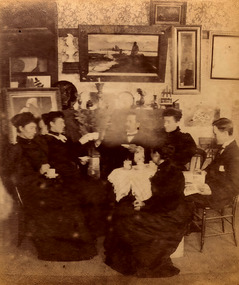
... Long Gully is a suburb of Bendigo, 3 km north-west of the city's centre. The Long Gully Creek signifies the physical location of the suburb, and the Long Gully reefs ran southwards from Eaglehawk. ...History House 11 Mackenzie Street Bendigo goldfields Long Gully is a suburb of Bendigo, 3 km north-west of the city's centre. The Long Gully Creek signifies the physical location of the suburb, and the Long Gully reefs ran southwards from Eaglehawk. ...Long Gully is a suburb of Bendigo, 3 km north-west of the city's centre. The Long Gully Creek signifies the physical location of the suburb, and the Long Gully reefs ran southwards from Eaglehawk. It was particularly rich, realising yields as high as five ounces of gold to the ton.Four black and white photos of a painter's studio in Creeth Street, Long Gully, Bendigo. The photos were of very low quality and have been restored as much as possible. The photos are of: 8679a Three women in long dresses and two men sitting around a table having tea in front of a mantle-piece. Several paintings are on the wall above. 8679b Four female artists (or students) painting pictures. They are supervised by a man and a woman. Various pieces of art are on the wall and floor around them. A painter's pallet is open on the floor in the foreground. 8679c Three women and one man are viewing pictures in the studio. 8679d Paintings on display in the studio history, bendigo, creeth street long gully, artist studio -
 Bendigo Historical Society Inc.
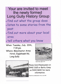
Document - LONG GULLY HISTORY GROUP COLLECTION: LONG GULLY HISTORY GROUP
... Long Gully History Group on 20th July (no year date) at the Manchester Arms Hotel, Eaglehawk Rd, Long Gully. One has a purple background on the top half of the page and the other is grey. There are two small photos: one is Looking up Eaglehawk Rd from the Long Gully Creek...History House 11 Mackenzie Street Bendigo goldfields BHS Collection BENDIGO History long gully history group The Long Gully History Group - Long Gully History Group Manchestor arms Hotel Carol Rasmussen Betty Camp Two two invitation flyers to meet the newly formed Long Gully History Group on 20th July (no year date) at the Manchester Arms Hotel, Eaglehawk Rd, Long Gully. One has a purple background on the top half of the page and the other is grey. There are two small photos: one is Looking up Eaglehawk Rd from the Long Gully Creek ...BHS CollectionTwo two invitation flyers to meet the newly formed Long Gully History Group on 20th July (no year date) at the Manchester Arms Hotel, Eaglehawk Rd, Long Gully. One has a purple background on the top half of the page and the other is grey. There are two small photos: one is Looking up Eaglehawk Rd from the Long Gully Creek, approx 1870 and the other is a Bridal Party and Manchester Arms, circa 1900.bendigo, history, long gully history group, the long gully history group - long gully history group, manchestor arms hotel, carol rasmussen, betty camp -
 Bendigo Historical Society Inc.
Document - LONG GULLY HISTORY GROUP COLLECTION: BANKNOTES AND JAMES BEVERAGE
... In the City's formative years the area that deposited its rain water into the Long Gully Creek was considered to be in Long Gully and for many years the Victoria Quartz Mine deposited many thousands of gallons of water into the Long Gully Creek. ...In the City's formative years the area that deposited its rain water into the Long Gully Creek was considered to be in Long Gully and for many years the Victoria Quartz Mine deposited many thousands of gallons of water into the Long Gully Creek. ...Victoria Quartz Gold Mine was on Victoria Hill, Ironbark, Bendigo. The Victoria Hill Quartz Gold Mines are scientifically important, as they contain relics span nearly sixty years of mining (1854 to 1913), documenting the richest and most significant years of Bendigo's world-famous quartz mining industry. Enhancing the significance of the place are relics from the Victoria Quartz Company operations, including, at 4,870 feet, the world's deepest nineteenth-century gold mining shaft. (Heritage Victoria) Geology of Victoria Hill: https://aigjournal.aig.org.au/wp-content/uploads/2019/12/AIG-Victoria-Hill-Mining-Reserve_FinalWeb.pdfTyped copy of what appears to be a speech. Mentioned is that after 1910 the Commonwealth took over the minting it's own money. Gold mining was chosen for the one pound note and a Bendigo scene was chosen. The scene chosen shows boring operations in the Victoria Quartz Mine. The picture was taken by Vincent Kelly of the five figures but for engraving only three were shown. They were Mr W Healy, Mr J Smith and Mr James Beverage. James Beverage was a member of Bendigo's first fire brigade. He went to Beechworth for a demonstration and on the way home stopped at Christie's Hotel in Swanston Street. There was a fire at the hotel and Mr Beverage rescued Mrs Christie, her baby and a servant. At a later date Mr Beverage saved a woman from a burning building in Moore Street in Bendigo. He received the Royal Humane Society's Medal which is now housed at the Bendigo Fire Station in Hargreaves Street. In the City's formative years the area that deposited its rain water into the Long Gully Creek was considered to be in Long Gully and for many years the Victoria Quartz Mine deposited many thousands of gallons of water into the Long Gully Creek. Mr Steve Gibbons unveiled the plaque.bendigo, history, long gully history group, the long gully history group - banknotes and james beverage, victoria quartz mine, vincent kelly, shepard's bush, mr rickards, mr abraham, mr w healy, mr j smith, mr james beverage, south iron bark mine, rae's hill, sandhurst no 1 fire brigade, christie's hotel, mrs christie, royal humane society's medal, bendigo fire station, long gully history group, mr steve gibbons, department of environment water heritage, arts commnmoration of historic events and famous persons -
 Bendigo Historical Society Inc.
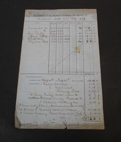
Financial record - Abbott Collection: Statement of the expenses of holding the election for Sandhurst
... On the first page break down of the expenses by division: Sandhurst A, Sandhurst B, Long Gully, Spring Creek, White Hills, Elysian Flat. ...On the first page break down of the expenses by division: Sandhurst A, Sandhurst B, Long Gully, Spring Creek, White Hills, Elysian Flat. ...Two pages statement of the expenses of holding the election for Sandhurst on the 22nd of February,1883. On the first page break down of the expenses by division: Sandhurst A, Sandhurst B, Long Gully, Spring Creek, White Hills, Elysian Flat. The second page gives the expenses by candidate: Burrowes, Clark, Perry, Quick, White. On the back of the second page in red pencil the words: final result of poll.state election, 1883, sandhurst -
 Bendigo Historical Society Inc.
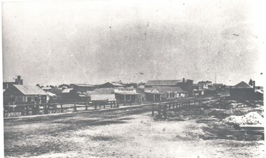
Photograph - HARRY BIGGS COLLECTION: LONG GULLY TOWNSHIP
... Harry Biggs Collection. 1 black & white photo of Long Gully township looking from Eaglehawk towards Bendigo near the bridge. On 1 shop can be seen P Pentreath. A wooden bridge can be seen over the creek. ...Long Gully Harry Biggs Collection Long Gully Township Photograph. Harry Biggs Collection. 1 black & white photo of Long Gully township looking from Eaglehawk towards Bendigo near the bridge. On 1 shop can be seen P Pentreath. A wooden bridge can be seen over the creek ...Photograph. Harry Biggs Collection. 1 black & white photo of Long Gully township looking from Eaglehawk towards Bendigo near the bridge. On 1 shop can be seen P Pentreath. A wooden bridge can be seen over the creek. Long Gully Township looking from Eaglehawk to Bendigo near bridge (written on the back).photograph, streetscape, long gully, harry biggs collection, long gully township -
 Bendigo Historical Society Inc.
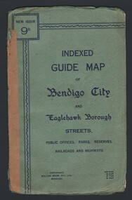
Map - INDEXED GUIDE MAP OF BENDIGO CITY & EAGLEHAWK BOROUGH, Early to mid 1920's
... Map shows the location of Sailors Gully, Peg Leg Gully, California Gully, Long Gully, Eaglehawk Creek, Bendigo Creek, Ironbark Creek. ...Map shows the location of Sailors Gully, Peg Leg Gully, California Gully, Long Gully, Eaglehawk Creek, Bendigo Creek, Ironbark Creek. ...Map. Indexed Guide Map of Bendigo City & Eaglehawk Borough. Folded map contained within blue booklet. Booklet is light blue printed with dark blue ink. Copyright Bolton Bros. Pty. Ltd. Bendigo. Printed on front. Map shows the location of Sailors Gully, Peg Leg Gully, California Gully, Long Gully, Eaglehawk Creek, Bendigo Creek, Ironbark Creek. Shows location of Showgrounds between Park St, Baxter Street, Barnard St and Bridge Lane. Shows location of Golden Square Railway Station between Panton St and Allingham St. Shows what is now known as Creek St. Nth & Sth as Clark St Nth & Sth. Also shows Tramway Terminus along Carpenter St and Golden Square Tram Terminus on High St, Golden Square. Map has a street index and an index for Public Offices, Parks and Reserves.map, bendigo, township, indexed guide map of bendigo city and eaglehawk borough -
 Bendigo Historical Society Inc.
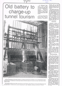
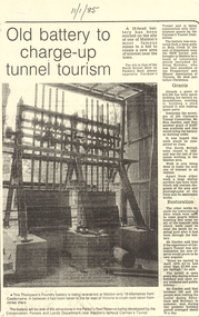
Newspaper - LONG GULLY HISTORY GROUP COLLECTION: 10 HEAD BATTERY
... History House 11 Mackenzie Street Bendigo goldfields BENDIGO History long gully history group The Long Gully History Group - 10 Head Battery Thompson's Foundry Battery Parkin's Reef Reserve Conservation Forests and Lands Department Carman's Tunnel North British Mine Parkins Reef Carman's Tunnel Committee Dr Doug Kemsley Prospectors' and Miners' Association of Victoria Mr Ken Garden Copy of a newspaper article titled Old battery to charge-up tunnel tourism. Date written on the paper is 11/1/85. The Thompson's Foundry Battery was re-erected in the Parkin's Reef Reserve after being used at Bola Creek ...Copy of a newspaper article titled Old battery to charge-up tunnel tourism. Date written on the paper is 11/1/85. The Thompson's Foundry Battery was re-erected in the Parkin's Reef Reserve after being used at Bola Creek near the NSW border. A team of volunteers and a Grant had it moved to Maldon where it was set up and the area made attractive for tourists.bendigo, history, long gully history group, the long gully history group - 10 head battery, thompson's foundry battery, parkin's reef reserve, conservation forests and lands department, carman's tunnel, north british mine, parkins reef, carman's tunnel committee, dr doug kemsley, prospectors' and miners' association of victoria, mr ken garden -
 Bendigo Historical Society Inc.
Document - CONSTABLE RYAN COLLECTION: GOLDFIELDS DISAPPEARANCE NEVER SOLVED, April 1991
... Creek Police Station... Constable Hayes... Long Gully...History House 11 Mackenzie Street Bendigo goldfields PERSON Individual Constable Thomas Ryan White Hills Station Chinese Camp Back Creek Police Station Constable Hayes Long Gully Police Station Constable Barry Constable Farrell Police Widows and Orphans Fund Hong Kee Ah Wong Wong Ching Young Thomas Ryan Inspector Kennedy Fook Sing Alick Ah Poo Gee Hing Mrs Go Wing Victorian Police Association Journal, Gary Presland Police Museum Photocopied article from the Victoria Police Association Journal of April 1991. ...Photocopied article from the Victoria Police Association Journal of April 1991. Goldfields disappearance never solved.Victorian Police Association Journal, Gary Presland Police Museumperson, individual, constable thomas ryan, white hills station, chinese camp, back creek police station, constable hayes, long gully police station, constable barry, constable farrell, police widows and orphans fund, hong kee, ah wong, wong ching young, thomas ryan, inspector kennedy, fook sing, alick ah poo, gee hing, mrs go wing -
 Bendigo Historical Society Inc.
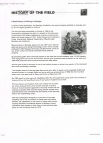
Document - LONG GULLY HISTORY GROUP COLLECTION: HISTORY OF THE FIELD (GOLD)
... History House 11 Mackenzie Street Bendigo goldfields BENDIGO History long gully history group The Long Gully History Group - History of the Field (Gold) Mrs Margaret Kennedy Mrs Farrell Edward Nucella Emmett Cave and Amos Victoria Quartz new Chum Railway Bendigo Amalgamated Gold Mies Bendigo Mines Ltd Deborah Mines William Burrell WMC Williams United Charshalton Bendigo Mining NL New Bendigo Project Trevor Clark Shelley Saunders Peter Wiseman New Bendigo - 10 Million Ounces of Gold Three pages of History of the Field, A Brief History of Mining in Bendigo. The history starts in 1851 when gold was discovered along the Bendigo Creek ...Three pages of History of the Field, A Brief History of Mining in Bendigo. The history starts in 1851 when gold was discovered along the Bendigo Creek to 1992 when Bendigo Mining NL purchased the licences and infrastructure from WMC. There are four small photos: Two men working a puddling machine; Victoria Hill - 1850's Open Cut; Victoria Hill Quartz Mine, and the Central Deborah Mine. There is also a web address in the top right corner.bendigo, history, long gully history group, the long gully history group - history of the field (gold), mrs margaret kennedy, mrs farrell, edward nucella emmett, cave and amos, victoria quartz, new chum railway, bendigo amalgamated gold mies, bendigo mines ltd, deborah mines, william burrell, wmc, williams united, charshalton, bendigo mining nl, new bendigo project, trevor clark, shelley saunders, peter wiseman, new bendigo - 10 million ounces of gold -
 Bendigo Historical Society Inc.
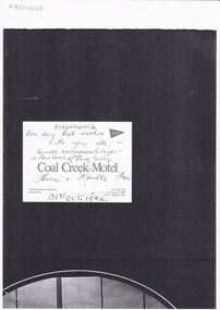
Photograph - LONG GULLY HISTORY GROUP COLLECTION: LONG GULLY SENIOR CITIZENS 24/10/1982
... long gully history group...The Long Gully History Group - Long Gully Senior Citizens 24/10/1982... Coal Creek...History House 11 Mackenzie Street Bendigo goldfields BENDIGO History long gully history group The Long Gully History Group - Long Gully Senior Citizens 24/10/1982 Coal Creek Motel Ethel Keith Sadie Peers Iris Swift Nell Finch Mary Webber Roy Rosewarne Jack Harper Doss Rosewarne Ethel Haig Val Fieldew Mary Wilson Bill Wilson Mrs E brown Mrs Elsie Marshall Mrs H Bond Leo Hambly D Vi Cameron Bonna Liddel Doris Stanford Bev Liddel Lila Robins Vene Long Sophie Reilly M? ...Group of Long Gully Senior Citizens photographed outside a building. they were on a bus tour to Korumburra, oct 24-30-1952. They are: Ethel Keith, Sadie Peers, Iris Swift, Nell Finch, Mary Webber, Roy Rosewarne, Jack Harper, Doss Rosewarne, Ethel Haig, Val Fieldew, Mary Wilson, Bill Wilson, Mrs E brown, Mrs Elsie Marshall, Mrs H Bond, Leo Hambly D, Vi Cameron, Bonna Liddel, Doris Stanford, Bev Liddel, Lila Robins, Vene Long, Sophie Reilly, M?t Harper, Alida Rattcliff, Cathie Logan, Jean OToole, Dorrie Crossley, Doris Mitchell, Bill Jurey, Eunice Pervis, Belle Jurey, Phyllis Cornish, Bill Cornish, Mary Harris, Leah Comte, Rex Ratcliff, Laurie OToole, Alan Crossley, Ula Angove, Amy Rowe and Dot Birrel.bendigo, history, long gully history group, the long gully history group - long gully senior citizens 24/10/1982, coal creek motel, ethel keith, sadie peers, iris swift, nell finch, mary webber, roy rosewarne, jack harper, doss rosewarne, ethel haig, val fieldew, mary wilson, bill wilson, mrs e brown, mrs elsie marshall, mrs h bond, leo hambly d, vi cameron, bonna liddel, doris stanford, bev liddel, lila robins, vene long, sophie reilly, m?t harper, alida rattcliff, cathie logan, jean otoole, dorrie crossley, doris mitchell, bill jurey, eunice pervis, belle jurey, phyllis cornish, bill cornish, mary harris, leah comte, rex ratcliff, laurie otoole, alan crossley, ula angove, amy rowe, dot birrel -
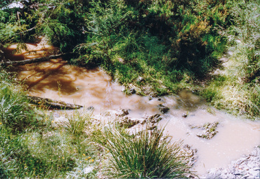 Eltham District Historical Society Inc
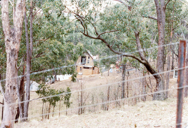
Photograph, Creek crossing, Long Gully Bushland Reserve, Panton Hill, 6 December 1992, 06/12/1992
... Creek crossing, Long Gully Bushland Reserve, Panton Hill, 6 December 1992...Eltham District Historical Society Inc 728 Main Rd Eltham melbourne The Eltham Horse Trail: Research and Warrandyte to Kinglake: Survey of proposed route, December 1992: (3) Kangaroo Ground to Kinglake eltham horse trail (1992 survey) panton hill long gully road Colour photograph Creek crossing, Long Gully Bushland Reserve, Panton Hill, 6 December 1992 Photograph ...The Eltham Horse Trail: Research and Warrandyte to Kinglake: Survey of proposed route, December 1992: (3) Kangaroo Ground to KinglakeColour photographeltham horse trail (1992 survey), panton hill, long gully road -
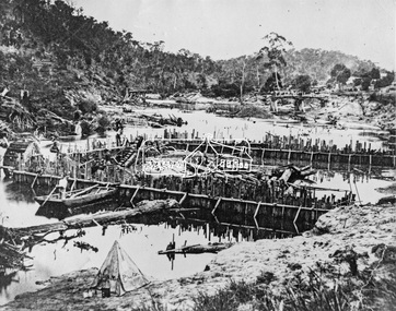 Eltham District Historical Society Inc
Negative - Photograph, Carl Walter 1831-1907, Coffer dam in the Yarra River at Anderson's Creek, 1864
... Gully. Remains of bridge built in 1860(?) wrecked by 1863 flood in background. Reproduced page 29 of ‘Pioneers & Painters’ Gold was first discovered in this area at Andersons Creek (Warrandyte) in June 1851 by Louis Michel. Discoveries north of the Yarra did not occur until about 1854. Although it took some months for a true rush to develop it was not long...Gully. Remains of bridge built in 1860(?) wrecked by 1863 flood in background. Reproduced page 29 of ‘Pioneers & Painters’ Gold was first discovered in this area at Andersons Creek (Warrandyte) in June 1851 by Louis Michel. Discoveries north of the Yarra did not occur until about 1854. Although it took some months for a true rush to develop it was not long ...1864 photograph of the Coffer Dam in the River Yarra situated (approximately) opposite Whipstick Gully. Remains of bridge built in 1860(?) wrecked by 1863 flood in background. Reproduced page 29 of ‘Pioneers & Painters’ Gold was first discovered in this area at Andersons Creek (Warrandyte) in June 1851 by Louis Michel. Discoveries north of the Yarra did not occur until about 1854. Although it took some months for a true rush to develop it was not long before alluvial workings were being carried on in most of the Shire of Eltham. The last area in which gold was discovered was Kinglake. As the gold became harder to find, deep mining took over from alluvial diggings in the gullies. Perhaps the most extensive of the deep workings was the Diamond Creek Mine just outside the boundary of the Shire. This form of mining was continued into the 1930s. There are believed to be some mines in the area still capable of producing gold but present prices make working these uneconomical. Some gold is still found by weekend prospectors. Photo: Carl Walter 1831-1907 – inscribed on tent “C. Walter Photo” The State Library of Victoria holds over 150 photos by Carl Walter, most of which are portraits of Aboriginal natives including William Barak.This photo forms part of a collection of photographs gathered by the Shire of Eltham for their centenary project book,"Pioneers and Painters: 100 years of the Shire of Eltham" by Alan Marshall (1971). The collection of over 500 images is held in partnership between Eltham District Historical Society and Yarra Plenty Regional Library (Eltham Library) and is now formally known as 'The Shire of Eltham Pioneers Photograph Collection.' It is significant in being the first community sourced collection representing the places and people of the Shire's first one hundred years.Digital image 4 x 5 inch B&W Neg (2) Print 20 x 25 cmshire of eltham pioneers photograph collection, anderson's creek, coffer dam, floods, gold mining, other areas, pioneers and painters, warrandyte, warrandyte bridge, yarra river -
 Eltham District Historical Society Inc
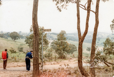
Photograph, Intersection of Spanish Gully Road and Clintons Road, Smiths Gully, c.Oct 1982, 1982
... long gully...smiths gully...spanish gully road...watsons creek...Eltham District Historical Society Inc 728 Main Rd Eltham melbourne 1982 clintons road long gully smiths gully spanish gully road watsons creek streets Colour photograph Intersection of Spanish Gully Road and Clintons Road, Smiths Gully, c.Oct 1982 Photograph ...Colour photograph1982, clintons road, long gully, smiths gully, spanish gully road, watsons creek, streets -
 Bendigo Historical Society Inc.
Document - LONG GULLY HISTORY GROUP COLLECTION:OLD BATTERY TO CHARGE-UP TUNNEL TOURISM
... History House 11 Mackenzie Street Bendigo goldfields BHS Collection BENDIGO History long gully history group The Long Gully History Group - Old battery to charge-up tunnel tourism Thompson's Foundry Parkin's Reef Reserve Conservation Forests and lands Department Carman's Tunnel North British Mine Carman's Tunnel Committee Dr Doug Kemsley The Prospectors' and Miners' Association of Victoria Mr Ken Garden Photocopy of a newspaper article titled Old battery to charge-up tunnel tourism. There is a photo of a Thompson's Foundry battery which is being re-erected at the site of the North British mine on Parkin's Reef, near Carman's tunnel. The battery was recovered from a deep gully at Bola Creek ...BHS CollectionPhotocopy of a newspaper article titled Old battery to charge-up tunnel tourism. There is a photo of a Thompson's Foundry battery which is being re-erected at the site of the North British mine on Parkin's Reef, near Carman's tunnel. The battery was recovered from a deep gully at Bola Creek. Other works include restoration of quartz roasting kilns and cyanide vats. Written at the top of the article is a date 11/1/85.bendigo, history, long gully history group, the long gully history group - old battery to charge-up tunnel tourism, thompson's foundry, parkin's reef reserve, conservation forests and lands department, carman's tunnel, north british mine, carman's tunnel committee, dr doug kemsley, the prospectors' and miners' association of victoria, mr ken garden -
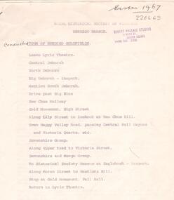 Bendigo Historical Society Inc.
Document - ALBERT RICHARDSON COLLECTION: TOUR OF BENDIGO GOLDFIELD 1967
... Document lists the names and details of mines covered on the tour, including the : Central Deborah, corner Violet and Creek Street North Deborah, Breen Street, Quarry Hill The Deborah, off Adams Street, Quarry Hill The New Chum Railway, Breen Street, Golden Square Eureka Extended South Belle Vue. The Hustlers Hill area history. New Chum Hill history Mines on the New Chum Hill and vicinity: Lansell's 180 New Chum and Victoria The Lazarus New Chum United New Chum consolidated Garibaldi Long Gully mines The Ironbark Carlisle United Hercules Document is signed by A. ...Document lists the names and details of mines covered on the tour, including the : Central Deborah, corner Violet and Creek Street North Deborah, Breen Street, Quarry Hill The Deborah, off Adams Street, Quarry Hill The New Chum Railway, Breen Street, Golden Square Eureka Extended South Belle Vue. The Hustlers Hill area history. New Chum Hill history Mines on the New Chum Hill and vicinity: Lansell's 180 New Chum and Victoria The Lazarus New Chum United New Chum consolidated Garibaldi Long Gully mines The Ironbark Carlisle United Hercules Document is signed by A. ...Seven page printed document. On top 'Royal Historical Society of Victoria, Bendigo Branch. Conducted tour of Bendigo Goldfields.' Easter 1967. Document lists the names and details of mines covered on the tour, including the : Central Deborah, corner Violet and Creek Street North Deborah, Breen Street, Quarry Hill The Deborah, off Adams Street, Quarry Hill The New Chum Railway, Breen Street, Golden Square Eureka Extended South Belle Vue. The Hustlers Hill area history. New Chum Hill history Mines on the New Chum Hill and vicinity: Lansell's 180 New Chum and Victoria The Lazarus New Chum United New Chum consolidated Garibaldi Long Gully mines The Ironbark Carlisle United Hercules Document is signed by A. Richardson.bendigo, mining, mine tour 1967 -
 Bendigo Historical Society Inc.
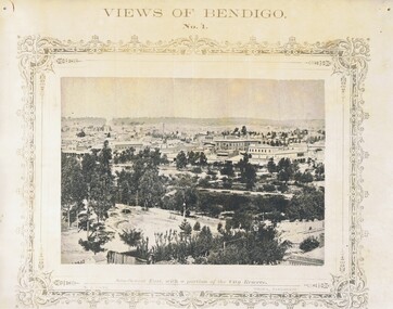
Photograph - NICHOLAS CAIRE VIEWS OF BENDIGO
... Paul's Church, tower and belfry. 9) View of the Camp Reserve as seen from the Court House. 10) View of North Old Chum showing surface excavations. 11) View as seen from the Camp Hill near the lodge. 12) Garden Gully amalgamated claims. 13) Shamrock Hotel, Sandhurst. 14) View as seen from Court House showing the willows & East Pall Mall. 15) Wesleyan Church, Golden Square. 16) Savings bank, Sandhurst. 17) The Bendigo district hospital. 18) Interior of the Wesleyan Church, Golden Square. 19) View of Golden Square township. 20) The Town Hall, City of Sandhurst. 21) The City Hotel, Sandhurst. 22) Pall Mall, Sandhurst. 23) Sandhurst City Market. 24) Pall Mall, Sandhurst looking west. 25) View from Camp Hill looking north - east 26) View of Charing Cross, Sandhurst. 27) View of Sandhurst as seen from Knipe's Castle. 28) Township of Long Gully. 29) View taken from St. Paul's tower. 30) View of the Sandhurst cemetery at back creek. 31) Kock's pioneer quartz crushing plant, Long Gully. 32) The New Masonic Hall, Sandhurst. 33) The Bendigo benevolent asylum and industrial school. 34) Bendigo flat as seen from Wattle Hill. 35) View of Old Chum Hill. 36) New Chum Gully as seen from Specimen Hill. 37) Township of Eaglehawk. 38) View from St. ...Paul's Church, tower and belfry. 9) View of the Camp Reserve as seen from the Court House. 10) View of North Old Chum showing surface excavations. 11) View as seen from the Camp Hill near the lodge. 12) Garden Gully amalgamated claims. 13) Shamrock Hotel, Sandhurst. 14) View as seen from Court House showing the willows & East Pall Mall. 15) Wesleyan Church, Golden Square. 16) Savings bank, Sandhurst. 17) The Bendigo district hospital. 18) Interior of the Wesleyan Church, Golden Square. 19) View of Golden Square township. 20) The Town Hall, City of Sandhurst. 21) The City Hotel, Sandhurst. 22) Pall Mall, Sandhurst. 23) Sandhurst City Market. 24) Pall Mall, Sandhurst looking west. 25) View from Camp Hill looking north - east 26) View of Charing Cross, Sandhurst. 27) View of Sandhurst as seen from Knipe's Castle. 28) Township of Long Gully. 29) View taken from St. Paul's tower. 30) View of the Sandhurst cemetery at back creek. 31) Kock's pioneer quartz crushing plant, Long Gully. 32) The New Masonic Hall, Sandhurst. 33) The Bendigo benevolent asylum and industrial school. 34) Bendigo flat as seen from Wattle Hill. 35) View of Old Chum Hill. 36) New Chum Gully as seen from Specimen Hill. 37) Township of Eaglehawk. 38) View from St. ...Full set (52 photos) of Nicholas Caire ''Views of Bendigo'' photographs. 1) Sandhurst East with a portion of the City Reserve. 2) New Chum line of reef. 3) Sandhurst-North part as seen from the top of the Masonic Hall. 4) The Hustler's line of reef seen from Redan Hill. 5) Battery of stampers for crushing quartz 6) View of Sandhurst as seen from the top of the New Masonic Hall. 7) Excavation of quartz reef near Ironbark Hill. 8) St. Paul's Church, tower and belfry. 9) View of the Camp Reserve as seen from the Court House. 10) View of North Old Chum showing surface excavations. 11) View as seen from the Camp Hill near the lodge. 12) Garden Gully amalgamated claims. 13) Shamrock Hotel, Sandhurst. 14) View as seen from Court House showing the willows & East Pall Mall. 15) Wesleyan Church, Golden Square. 16) Savings bank, Sandhurst. 17) The Bendigo district hospital. 18) Interior of the Wesleyan Church, Golden Square. 19) View of Golden Square township. 20) The Town Hall, City of Sandhurst. 21) The City Hotel, Sandhurst. 22) Pall Mall, Sandhurst. 23) Sandhurst City Market. 24) Pall Mall, Sandhurst looking west. 25) View from Camp Hill looking north - east 26) View of Charing Cross, Sandhurst. 27) View of Sandhurst as seen from Knipe's Castle. 28) Township of Long Gully. 29) View taken from St. Paul's tower. 30) View of the Sandhurst cemetery at back creek. 31) Kock's pioneer quartz crushing plant, Long Gully. 32) The New Masonic Hall, Sandhurst. 33) The Bendigo benevolent asylum and industrial school. 34) Bendigo flat as seen from Wattle Hill. 35) View of Old Chum Hill. 36) New Chum Gully as seen from Specimen Hill. 37) Township of Eaglehawk. 38) View from St. Paul's tower looking south west. 39) View of the railway tunnel through the Big Hill, near Mt. Herbert. 40) View taken from St. Paul's looking south. 41) Scene taken from St. Paul's tower looking eastward. 42) View of Sandhurst from St. Paul's tower looking north-west. 43) The great extended Hustler's co's. quartz mining claim. 44) View from the Big Hill showing the line of railway to Melbourne. 45) View from St. Paul's Church tower looking westward. 46) View from St. Paul's Church tower looking north-west. 47) Scene near the Big Hill ranges taken from Mr. Buick's residence. 48) View from St. Paul's Church tower looking north eastward. 49) Township of Eaglehawk 50) View of Mitchell Street, Sandhurst. 51) Botanical gardens near the White Hills. 52) View Point, Sandhurst.bendigo, streetscape, various views, nicholas cairne -
 Bendigo Historical Society Inc.
Document - LISTS OF ITEMS AUCTIONED AT BENDIGO MINES
... Coy 18th August 1938 Ross Creek Extended G.M.Coy Ross Creek Mines Account Mines Dept Pitfield Plains, Glenfine South Shaft Adelong Dredge and leases 10th February 1943 Bright Valley Dredge 9,10th February 1943 Exchequer Extended North Chewton 18th October, 1939 Talbot Alluvials Norbury's No. 2 shaft 5th May 1941 Gordon Gold Mine Inglewood 30th April 1940 Postg Office Hill Mine Chewton 7th February 1940 Carlisle & Whittaker Plant Buninyong Rand Yandoit Mine North Chewton 19th October 1939 Spring Gully Mine Chewton 14th Decembert 1938 Eureka Central Chewton 26th February 1941The Golod Mine Clunes 15th March 1941 Guildford Plateau 20th Novemer 1940 New Long Tunnel Walhalla 12th February 1941 Napoleon BML 28th October 1941 Alfords Battery Hercules No. 1 Mine 12th February 1942 Ramrod Gold Mine Bendigo 19th March 1942 Bendigo Amalgamated Goldfields Limited 10th and 11th August 1938 Virginia South Extended 1st June 1938...Coy 18th August 1938 Ross Creek Extended G.M.Coy Ross Creek Mines Account Mines Dept Pitfield Plains, Glenfine South Shaft Adelong Dredge and leases 10th February 1943 Bright Valley Dredge 9,10th February 1943 Exchequer Extended North Chewton 18th October, 1939 Talbot Alluvials Norbury's No. 2 shaft 5th May 1941 Gordon Gold Mine Inglewood 30th April 1940 Postg Office Hill Mine Chewton 7th February 1940 Carlisle & Whittaker Plant Buninyong Rand Yandoit Mine North Chewton 19th October 1939 Spring Gully Mine Chewton 14th Decembert 1938 Eureka Central Chewton 26th February 1941The Golod Mine Clunes 15th March 1941 Guildford Plateau 20th Novemer 1940 New Long Tunnel Walhalla 12th February 1941 Napoleon BML 28th October 1941 Alfords Battery Hercules No. 1 Mine 12th February 1942 Ramrod Gold Mine Bendigo 19th March 1942 Bendigo Amalgamated Goldfields Limited 10th and 11th August 1938 Virginia South Extended 1st June 1938 Document LISTS OF ITEMS AUCTIONED AT BENDIGO MINES ...Typed copies of catalogues of items to be auctioned at the following mines: South Red, White and Blue 12th April 1938 Central Blue 28th October, 1941 at 11 a.m South Virginia Extended (found inside Central Blue catalogue) Big Blue 21st November, 1939 at 10.30 a.m Golden Transverse Bendigo 3rd September 1941Yandoit Co 19th April 1939 Chapman's Gold Mine Chewton 8th February 1939 Ross Creek Extended G.M. Coy 18th August 1938 Ross Creek Extended G.M.Coy Ross Creek Mines Account Mines Dept Pitfield Plains, Glenfine South Shaft Adelong Dredge and leases 10th February 1943 Bright Valley Dredge 9,10th February 1943 Exchequer Extended North Chewton 18th October, 1939 Talbot Alluvials Norbury's No. 2 shaft 5th May 1941 Gordon Gold Mine Inglewood 30th April 1940 Postg Office Hill Mine Chewton 7th February 1940 Carlisle & Whittaker Plant Buninyong Rand Yandoit Mine North Chewton 19th October 1939 Spring Gully Mine Chewton 14th Decembert 1938 Eureka Central Chewton 26th February 1941The Golod Mine Clunes 15th March 1941 Guildford Plateau 20th Novemer 1940 New Long Tunnel Walhalla 12th February 1941 Napoleon BML 28th October 1941 Alfords Battery Hercules No. 1 Mine 12th February 1942 Ramrod Gold Mine Bendigo 19th March 1942 Bendigo Amalgamated Goldfields Limited 10th and 11th August 1938 Virginia South Extended 1st June 1938 -
 Bendigo Historical Society Inc.
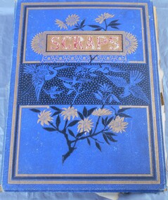
Book - Wells Family scrapbook
... In 1852 the two men were at the Golden Gully area of the Fryers Creek gold fields, they then move to Bendigo, initially to White Hills before settling in Long Gully. ...In 1852 the two men were at the Golden Gully area of the Fryers Creek gold fields, they then move to Bendigo, initially to White Hills before settling in Long Gully. ...George Edwin Wells was born in Oxford in 1826. He served an apprenticeship as a coachbuilder and in 1841 he went to New Zealand. He was returning to England in 1848 when he changed his mind in Singapore and turned around and came to Melbourne. He operated a store with Mr W Gibbs and when gold as discovered they left their wives in Melbourne and went to the gold fields of Ballarat in 1851. At this time George was newly married to Catherine Kiely. In 1852 the two men were at the Golden Gully area of the Fryers Creek gold fields, they then move to Bendigo, initially to White Hills before settling in Long Gully. They then brought their patient wives, who had only had visits from their husbands, to Bendigo. George had several successful mining ventures in Bendigo. He died in 1898. One of his sons, Alfred, married Margaret Rotherham in NSW where he was living. Alfred died in 1911 leaving Margaret with a young family. She moved to Bendigo to be nearer to family support. Alfred and Margaret's daughter, Elma Winslade Wells 91904 - 19/1/1988) became a teacher and was posted to Camp Hill Primary School. She was also heavily involved in the Scout movement in the Bendigo area.Blue hardcover scrapbook belonging to the Wells family. (Elma Wells). The cover has gold, black and blue flowers and birds on it. The word "scraps" in red within a gold rectangular box completes the cover. Inside all the pages are filled with drawing and pictures of people, animals, flowers and landscapes. Also, various poems are transcribed on the pages. Newspaper cuttings are also glued to pages and in two yellow envelopes.Inside cover in pencil: The Wells Family scrap book donated to the Royal Historical Society Bendigo Branch by Miss Elma W. Wellsfamily history, wells family -
 Bendigo Historical Society Inc.
Document - LYDIA CHANCELLOR COLLECTION: BENDIGO METHODIST CHURCHES PLAN 1905 AND CHURCH OFFICIALS, 1905
... LYDIA CHANCELLOR COLLECTION: Bendigo Methodist Churches Plan 1905 and church officials Quarterly Pastoral Visitation of Classes Circuit plan for Forest St, Golden square, Eaglehawk West, Eaglehawk East, California Hill, California Gully, Long Gully, McKenzie St, Galvin St, Rowan St, Arnold St, Iron Bark, Buckly St, Specimen Hill, Quarry Hill, Bridge St, Retreat Road, Kangaroo Flat, Lockwood, East Shelbourne, White Hills, Epsom, Huntly, Bagshot, fosterville, Strathfieldsaye, Axe Creek, sheepwash, Nerring, Leichardt, Leichardt East, Marong, Golden Fleece, Golden Gully, Dowling St Mission, Benevolent Asylum, Hospital Income and Expenditure List of stewards Notices Pastorates Evangelistic Bands...History House 11 Mackenzie Street Bendigo goldfields BENDIGO History schooling LYDIA CHANCELLOR COLLECTION: Bendigo Methodist Churches Plan 1905 and church officials Quarterly Pastoral Visitation of Classes Circuit plan for Forest St, Golden square, Eaglehawk West, Eaglehawk East, California Hill, California Gully, Long Gully, McKenzie St, Galvin St, Rowan St, Arnold St, Iron Bark, Buckly St, Specimen Hill, Quarry Hill, Bridge St, Retreat Road, Kangaroo Flat, Lockwood, East Shelbourne, White Hills, Epsom, Huntly, Bagshot, fosterville, Strathfieldsaye, Axe Creek, sheepwash, Nerring, Leichardt, Leichardt East, Marong, Golden Fleece, Golden Gully, Dowling St Mission, Benevolent Asylum, Hospital Income and Expenditure List of stewards Notices Pastorates Evangelistic Bands Document LYDIA CHANCELLOR COLLECTION: BENDIGO METHODIST CHURCHES PLAN 1905 AND CHURCH OFFICIALS ...LYDIA CHANCELLOR COLLECTION: Bendigo Methodist Churches Plan 1905 and church officials Quarterly Pastoral Visitation of Classes Circuit plan for Forest St, Golden square, Eaglehawk West, Eaglehawk East, California Hill, California Gully, Long Gully, McKenzie St, Galvin St, Rowan St, Arnold St, Iron Bark, Buckly St, Specimen Hill, Quarry Hill, Bridge St, Retreat Road, Kangaroo Flat, Lockwood, East Shelbourne, White Hills, Epsom, Huntly, Bagshot, fosterville, Strathfieldsaye, Axe Creek, sheepwash, Nerring, Leichardt, Leichardt East, Marong, Golden Fleece, Golden Gully, Dowling St Mission, Benevolent Asylum, Hospital Income and Expenditure List of stewards Notices Pastorates Evangelistic Bandsbendigo, history, schooling