Showing 187 items matching "longitudinal "
-
 Melbourne Tram Museum
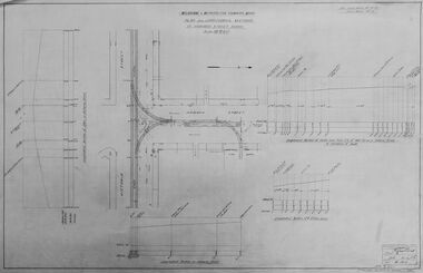
Drawing - Digtial image, Melbourne & Metropolitan Tramways Board (MMTB), "Plan and Longitudinal sections of Howard Street Siding", 2/1925
... "Plan and Longitudinal sections of Howard Street Siding"...Shows the plan and longitudinal sections. Prepared 23/2/1925 and signed by Mr Strickland Chief Engineer on 25/2/1925. ...Digital image of drawing P1613, "Plan and Longitudinal sections of Howard Street Siding"....Shows the plan and longitudinal sections. Prepared 23/2/1925 and signed by Mr Strickland Chief Engineer on 25/2/1925. ...Digital image of a drawing for the access tracks to the Howard St car house or cable tram depot from Victoria St. Shows the plan and longitudinal sections. Prepared 23/2/1925 and signed by Mr Strickland Chief Engineer on 25/2/1925. This depot was made necessary by the construction of electric tram tracks in Flemington Road in 1925 which resulted in the closure of the Flemington Road car house near Racecourse Road North Melbourne.Yields information about the access track from Victoria St to the Howard St car house. Digital image of drawing P1613, "Plan and Longitudinal sections of Howard Street Siding".m&mtb, drawings, howard st, cable trams, car houses, depots -
 Federation University Historical Collection
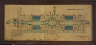
Drawing, Longitudinal Section 15 B.L. Turbine, 1921
... Longitudinal Section 15 B.L. Turbine...Framed drawing of a longitudinal section of a 15 B.L. Turbine. It was drawn by R.O.S. and C.B. on 31 July 1919 and traced by N. ...Brown on 07 October 1921. Longitudinal Section 15 B.L. Turbine Drawing N. ...This work most probably hung in a laboratory at the Ballarat School of Mines.Framed drawing of a longitudinal section of a 15 B.L. Turbine. It was drawn by R.O.S. and C.B. on 31 July 1919 and traced by N. Brown on 07 October 1921.turbine, n. brown, ballarat school of mines -
 Bacchus Marsh & District Historical Society
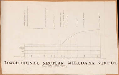
Drawing, Longitudinal Section Millbank Street Bacchus Marsh circa 1905
... Longitudinal Section Millbank Street Bacchus Marsh circa 1905...Single page plan showing a longitudinal section view of MIllbank Street running from Clarinda Street to Grant Street in Bacchus Marsh. ...High resolution digital image stored on BMDHS computer network. Longitudinal Section Millbank Street Bacchus Marsh circa 1905 Drawing Shire of Bacchus Marsh ...Millbank Street is a short street located close to the central business and shopping area of Bacchus Marsh. In the early 1900s works to improve the drainage of the street were discussed and planned by Bacchus Marsh Shire Council. This plan is most probably the plan discussed at a Shire Council meeting in April 1905. Single page plan showing a longitudinal section view of MIllbank Street running from Clarinda Street to Grant Street in Bacchus Marsh. The names of Millbank Street property owners, Cain, Shelley, Oliver and Ramsay are marked on this plan. Scale: Vertical 10 feet to 1 inch. Horizontal: 100 links to 1 inch Part of a set of maps which are pasted into a bound volume containing 76 maps or plans in total. High resolution digital image stored on BMDHS computer network. bacchus marsh victoria maps, millbank street bacchus marsh -
 Port Melbourne Historical & Preservation Society
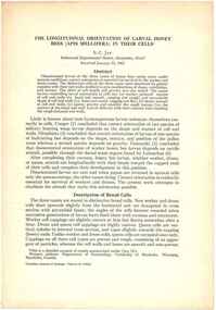
Plan - Cross sectional drawing, recommendations by Sir John Coode, Thomas Kell Lith, 1880
... Large cross sectional drawing of longitudinal and cross section of works as recommended by Sir John Coode in his 1879 report...Melbourne Harbour Trust Longitudinal and Cross section of works...Port Melbourne Historical & Preservation Society Port Melbourne Town Hall 333 Bay Street Port Melbourne melbourne built environment engineering - canals and drainage melbourne harbor trust - port of melbourne authority sir john coode coode canal hobsons bay Melbourne Harbour Trust Longitudinal and Cross section of works Large cross sectional drawing of longitudinal and cross section of works as recommended by Sir John Coode in his 1879 report Plan Cross sectional drawing, recommendations by Sir John Coode Thomas Kell Lith ...Large cross sectional drawing of longitudinal and cross section of works as recommended by Sir John Coode in his 1879 reportMelbourne Harbour Trust Longitudinal and Cross section of worksbuilt environment, engineering - canals and drainage, melbourne harbor trust - port of melbourne authority, sir john coode, coode canal, hobsons bay -
 Wheen Bee Foundation
Publication, Jay, S. C, The longitudinal orientation of larval honey bees (Apis mellifera) in their cells (Jay, S. C.), Ottawa, 1963, 1963
... The longitudinal orientation of larval honey bees (Apis mellifera) in their cells (Jay, S. ...Wheen Bee Foundation 87 Ford Street Beechworth The longitudinal orientation of larval honey bees (Apis mellifera) in their cells (Jay, S. ... -
Stawell Historical Society Inc
Map, Stawell Gold Mine, SGM Mineralized System Longitudinal Projection showing Diamond Drilling Holes 2007, June 2007
... SGM Mineralized System Longitudinal Projection showing Diamond Drilling Holes 2007...Stawell Historical Society Inc 46 Longfield St Stawell grampians mining gold map Legend of Mine workings numbered. 1980's Section of Big Hill showing Diamond Drill holes through Magdala, Magdala North and Golden Gift Ore bodies to 2000m level SGM Mineralized System Longitudinal Projection showing Diamond Drilling Holes 2007 Map Stawell Gold Mine ...Section of Big Hill showing Diamond Drill holes through Magdala, Magdala North and Golden Gift Ore bodies to 2000m levelLegend of Mine workings numbered. 1980's mining, gold, map -
Moorabbin Air Museum
Booklet - CAC Commonwealth Aircraft Corporation, CA-22 Flight Test Report on Longitudinal Stability
... CA-22 Flight Test Report on Longitudinal Stability...Moorabbin Air Museum Moorabbin Airport 12 First Street Moorabbin melbourne CA-22 Flight Test Report on Longitudinal Stability Booklet CAC Commonwealth Aircraft Corporation ... -
Moorabbin Air Museum
Document (item) - The Effects Of Power On The Trim And Longitudinal Stability
... The Effects Of Power On The Trim And Longitudinal Stability...Moorabbin Air Museum Moorabbin Airport 12 First Street Moorabbin melbourne The affects of power on the flight characteristics of the AA-107 aircraft The Effects Of Power On The Trim And Longitudinal Stability Document The Effects Of Power On The Trim And Longitudinal Stability ...The affects of power on the flight characteristics of the AA-107 aircraft -
Moorabbin Air Museum
Document (Item) - ARL - The Effect Of Rocket Fuel Pods On The Longitudinal Stability And Drag Of Jindivik Target Aircraft
... ARL - The Effect Of Rocket Fuel Pods On The Longitudinal Stability And Drag Of Jindivik Target Aircraft...Moorabbin Air Museum Moorabbin Airport 12 First Street Moorabbin melbourne Aerodynamics Note 199 ARL - The Effect Of Rocket Fuel Pods On The Longitudinal Stability And Drag Of Jindivik Target Aircraft Document ARL - The Effect Of Rocket Fuel Pods On The Longitudinal Stability And Drag Of Jindivik Target Aircraft ...Aerodynamics Note 199 -
Moorabbin Air Museum
Manual (Item) - Longitudinal Stability for Aircraft - In FRENCH
... Longitudinal Stability for Aircraft - In FRENCH...Moorabbin Air Museum Moorabbin Airport 12 First Street Moorabbin melbourne Longitudinal Stability for Aircraft - In FRENCH Manual Longitudinal Stability for Aircraft - In FRENCH ... -
Moorabbin Air Museum
Document (item) - Many graphs, Nomad longitudinal characteristics
... Nomad longitudinal characteristics...Moorabbin Air Museum Moorabbin Airport 12 First Street Moorabbin melbourne Nomad longitudinal characteristics Document Many graphs ... -
 Federation University Historical Collection
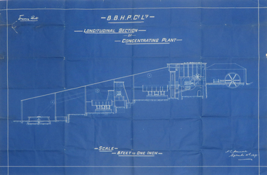
Plan, Blueprint B.B.H.P. Co Ltd Longitudinal Section of Concentrating Plant, 1895
... Blueprint B.B.H.P. Co Ltd Longitudinal Section of Concentrating Plant...blueprint h. l. hancock longitudinal section concentrating plant BHP Blueprint plan by H.L. ...Blueprint plan by H.L. Hancock blueprint, h. l. hancock, longitudinal section, concentrating plant, bhp -
Federation University Historical Collection
Plan, Ballarat East Longitudinal Section, not dated
... Ballarat East Longitudinal Section ...plan ballarat east longitudinal section mining Printed plan of Ballarat East showing pitch of quartz veins and crosscourses Sheet No 2 Ballarat East Longitudinal Section Plan Plan ...Printed plan of Ballarat East showing pitch of quartz veins and crosscourses Sheet No 2plan, ballarat east, longitudinal section, mining -
Moorabbin Air Museum
Book - Aeronautical Engineering, A Summary and Analysis of the Low Speed Longitudinal Characteristics of Swept Wings at High Reynolds Number
... A Summary and Analysis of the Low Speed Longitudinal Characteristics of Swept Wings at High Reynolds Number...Aeronautical engineering Flow considerations Longitudinal stability Stall control Horizontal tail Lift Drag Summary & analyses of low speed characteristics of swept wings, circa 1957 A Summary and Analysis of the Low Speed Longitudinal Characteristics of Swept Wings at High Reynolds Number Book Aeronautical Engineering ...Summary & analyses of low speed characteristics of swept wings, circa 1957non-fictionSummary & analyses of low speed characteristics of swept wings, circa 1957flow considerations, longitudinal stability, stall control, horizontal tail, lift, drag -
 Kiewa Valley Historical Society
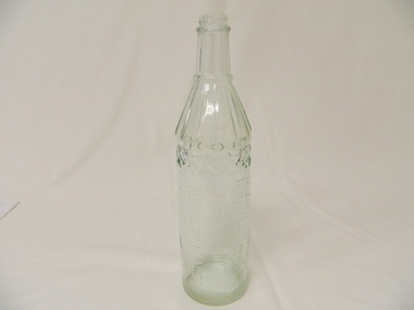
Bottle - Spirits, 1940's
... Clear glass whisky bottle with heavy embossing on one side where the maker's name and details is printed in capital letters longitudinally. Heavily embossed zig zag pattern at the top of straight sides that go three quarters of the way up. ...Side (longitudinally): 'This Bottle is the Property of / James Dickson & Co. ...Aesthetic: Display showing embossing and shape whisky bottle spirit james dickson co. pty. ltd Side (longitudinally): 'This Bottle is the Property of / James Dickson & Co. ...Whisky came in bottles sold at licensed premises either locally or in larger cities visited during shopping expeditions. The shape of bottles varied. Bottles were recycled remaining the property of the manufacturer who paid for their return. History of James Dickson Co. Pty. Ltd.Historical: Change of Bottles - shape, glass, embossing. Collected by bottle collectors. Aesthetic: Display showing embossing and shapeClear glass whisky bottle with heavy embossing on one side where the maker's name and details is printed in capital letters longitudinally. Heavily embossed zig zag pattern at the top of straight sides that go three quarters of the way up. The sides taper to the neck which has straight sides to the screw top opening. The tapered section is grooved with ridges of straight lines to a lip which is between it and the neck. Side (longitudinally): 'This Bottle is the Property of / James Dickson & Co. Pty Ltd / Established 1854 / Melbourne Aust. / And Cannot Be Legally Used By Others' Base: 'A' above 'F892' and 'M' beneath. Reading from the inside of the bottle on the base is 'E41' whisky, bottle, spirit, james dickson co. pty. ltd -
Port Melbourne Historical & Preservation Society
Plan - Raglan Street, Port Melbourne, Borough of Sandridge, 1890s
... Plan of Raglan Street showing longitudinal section....Plan of Raglan Street showing longitudinal section. Plan Raglan Street, Port Melbourne Borough of Sandridge ...Plan of Raglan Street showing longitudinal section.Chas Clay (Borough Surveyor):E. Clark (Town Clerk):John Clang (Contractor ?)raglan street, engineering - roads streets lanes and footpaths, town clerks, charles clay, edward clark -
 Federation University Historical Collection
Plan, Madame Bent Gold Mining Company, not dated
... A large plane showing a longitudinal section of the mine....madame bent gold mining company mining A large plane showing a longitudinal section of the mine. Madame Bent Gold Mining Company Plan Plan ...A large plane showing a longitudinal section of the mine.madame bent gold mining company, mining -
Port Melbourne Historical & Preservation Society
Plan - Heath Street, Port Melbourne, Borough of Sandridge, Mar 1864
... Plan of longitudinal and cross sections of proposed works in Heath Street....Kelly (Borough Surveyor) Plan of longitudinal and cross sections of proposed works in Heath Street. ...Plan of longitudinal and cross sections of proposed works in Heath Street.M. Tierney:Denis Sullivan:Thos. P. Warren:Geo. Kelly (Borough Surveyor)engineering - roads streets lanes and footpaths, m tierney, denis sullivan, thomas p warren, george kelly -
Port Melbourne Historical & Preservation Society
Plan - Lyons Street, Port Melbourne, Borough of Sandridge, 9 Oct 1877
... Plan of Lyons Street, showing longitudinal section, ground plan and transverse section....Port Melbourne Historical & Preservation Society Port Melbourne Town Hall 333 Bay Street Port Melbourne melbourne Engineering - Roads Streets Lanes and Footpaths Michael MINAHAN Edward CLARK Town Clerks Minehan, Michael:Clark, Edward C (Town Clerk) Plan of Lyons Street, showing longitudinal section, ground plan and transverse section. ...Plan of Lyons Street, showing longitudinal section, ground plan and transverse section.Minehan, Michael:Clark, Edward C (Town Clerk)engineering - roads streets lanes and footpaths, michael minahan, edward clark, town clerks -
 Bendigo Historical Society Inc.
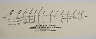
Map - SHEEPSHEAD LINE OF REEF, Circa 1940's
... Map: Plan showing a Longitudinal section of the Sheepshead line of Reefs , Bendigo. (34 Copies)...History House 11 Mackenzie Street Bendigo goldfields MAP Bendigo mining plan Sheepshead line of Reef Gold mines Mining Map: Plan showing a Longitudinal section of the Sheepshead line of Reefs , Bendigo. (34 Copies) Map SHEEPSHEAD LINE OF REEF ...Map: Plan showing a Longitudinal section of the Sheepshead line of Reefs , Bendigo. (34 Copies)map, bendigo, mining plan, sheepshead line of reef, gold mines , mining -
 Bendigo Historical Society Inc.
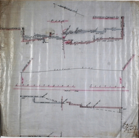
Plan - Goldfields Consolidated Co
... Plan and longitudinal section of Goldfields North and Goldfields Consolidated Co, hand drawn on waxed paper. ...Written on plan: 'Longitudinal Section' and 'W.H. Cundy, July 14th, 1908'. ...Goldfields North and Goldfields Consolidated Co. were located near Diamond Hill, Spring Gully.Plan and longitudinal section of Goldfields North and Goldfields Consolidated Co, hand drawn on waxed paper. Written on plan: 'Longitudinal Section' and 'W.H. Cundy, July 14th, 1908'. Plan forms part of the Margaret Roberts Collection of mining records. margaret roberts, gold, gold mine, goldfields consolidated co., bendigo -
 Port Melbourne Historical & Preservation Society
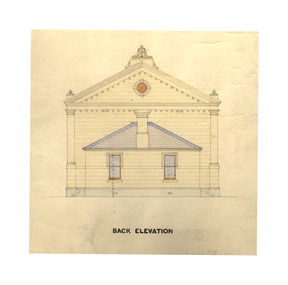
Plan - Town Hall, Sandridge, 1860s
... Longitudinal, traverse, side and back elevation drawings for original Town Hall, Sandridge 1869 (No. 2) ...June 19th (pencil drawing) Longitudinal, traverse, side and back elevation drawings for original Town Hall, Sandridge 1869 (No. 2) Plan Town Hall, Sandridge ...Longitudinal, traverse, side and back elevation drawings for original Town Hall, Sandridge 1869 (No. 2) William Ireland:Witness Henry Bates:Reverse side: Plans of Town Hall, old and new. June 19th (pencil drawing)port melbourne town hall, built environment - civic, sandridge town hall -
 Bendigo Historical Society Inc.
Map - Hustler's Line of Reef
... Longitudinal section of Hustler's Reef & Hustler's Reef no. 1 mine. ...Hustler's Reef Bendigo Goldfields Hustler's Reef No.1 Mine Longitudinal section of Hustler's Reef & Hustler's Reef no. 1 mine. ...Longitudinal section of Hustler's Reef & Hustler's Reef no. 1 mine. Plate XX, note plates 4,8,13,20, 26 & 31 form a longitudinal section from Fortuna Hustler's to Hustler's Consols Mine. produced by the underground survey office, Bendigo, September 1913.hustler's reef, bendigo goldfields, hustler's reef no.1 mine -
 RMIT Design Archives
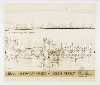
Architectural drawings, Urban Landscape Design - North Fitzroy
... Detailled Area plan of the Urban Renewal Project in North Fitzroy. Features the longitudinal section at Rowe St....RMIT Design Archives RMIt University, Building 100 154 Victoria Street Carlton melbourne ink acetate Detailled Area plan of the Urban Renewal Project in North Fitzroy. Features the longitudinal section at Rowe St. Urban Landscape Design - North Fitzroy Architectural drawings Edmond, Robin Edmond, Robin ...Detailled Area plan of the Urban Renewal Project in North Fitzroy. Features the longitudinal section at Rowe St.ink, acetate -
 University of Melbourne, Burnley Campus Archives
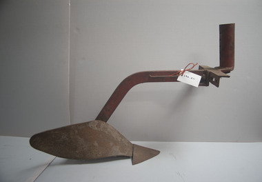
Tool - Plough, Unknown
... Plough consists of three point hitch, moldboard and ploughshare on longitudinal beam....Plough consists of three point hitch, moldboard and ploughshare on longitudinal beam. Plough Tool Plough ...Steel plough attachment for an implement for ploughing furrows. Plough consists of three point hitch, moldboard and ploughshare on longitudinal beam.tillage, ploughing, implement, tillage implement, artifact -
 Bendigo Historical Society Inc.
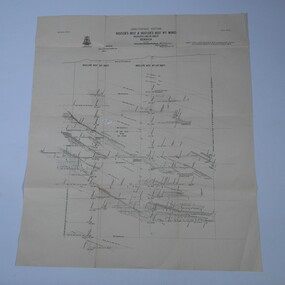
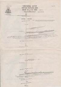
Map - STRUGNELL COLLECTION: HUSTLER'S LINE OF REEF, BENDIGO
... Map, Hustler's Line of Reef, Bendigo, Fortuna Hustler's Mine, Longitudinal Section. Plate No. 1V (4). NOTE--- Plates 4,8,13,29,26 & 31 form a Longitudinal Section from Fortuna Hustler's to Hustler's Consols Mine.Bulletin No 33 Signed H.A.Whitelaw. ...Map, Hustler's Line of Reef, Bendigo, Fortuna Hustler's Mine, Longitudinal Section. Plate No. 1V (4). NOTE--- Plates 4,8,13,29,26 & 31 form a Longitudinal Section from Fortuna Hustler's to Hustler's Consols Mine.Bulletin No 33 Signed H.A.Whitelaw. ...Map, Hustler's Line of Reef, Bendigo, Fortuna Hustler's Mine, Longitudinal Section. Plate No. 1V (4). NOTE--- Plates 4,8,13,29,26 & 31 form a Longitudinal Section from Fortuna Hustler's to Hustler's Consols Mine.Bulletin No 33 Signed H.A.Whitelaw. Drawing shows the vertical shaft descending to over 2228 feetUnderground Survey Office, Bendigo.map, bendigo, fortuna hustler's mine -
 Kiewa Valley Historical Society
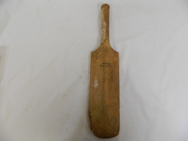
Rounders Bat
... The face of the bat is flat and the other side becomes thicker (is tapered) towards the centre in a longitudinal direction. The handle is cylindrical....The face of the bat is flat and the other side becomes thicker (is tapered) towards the centre in a longitudinal direction. The handle is cylindrical. ...This rounders bat was used by the students at Bogong Primary School.Historical: Bogong Primary School was opened for the Kiewa Hydro Electric Scheme workers. Provenance: Bogong Primary School sport.Wooden bat. The face of the bat is flat and the other side becomes thicker (is tapered) towards the centre in a longitudinal direction. The handle is cylindrical.'Champion' 3 quarters of the way up the bat towards the handle on the flat side of the bat. On the reverse side same position, Made in / Pakistan. On the flat side: Bogong has been written in thick black but faded paint.rounders. sport. bogong primary school. kiewa hydro electric scheme. game -
Port Melbourne Historical & Preservation Society
Plan - Ingles Street, Port Melbourne, 12 Jan 1866
... Plans for Ingles Street showing both ground plan and longitudinal and traverse sections at Station Place, Heath, Nott and Bay Streets....Plans for Ingles Street showing both ground plan and longitudinal and traverse sections at Station Place, Heath, Nott and Bay Streets. ...Plans for Ingles Street showing both ground plan and longitudinal and traverse sections at Station Place, Heath, Nott and Bay Streets.Signed by surveyor Chas. Clay and James Bibby plus Thomas (Reek) Warren as witness to latter sig. Also a no: 355/H1 added later.engineering - roads streets lanes and footpaths, charles clay, thomas (reek) warren, james bibby -
 University of Melbourne, Burnley Campus Archives
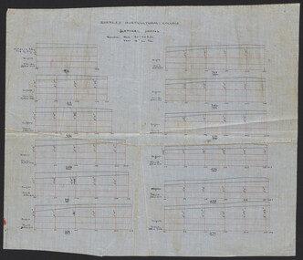
Plan, Burnley Horticultural College Lateral Drains, c.1930
... Hand drawn on waxed linen. (1) Lateral Drains. (2) Longitudinal Section. From A.W. Jessep file, "Improvements (Completed)."...Jessep Hand drawn on waxed linen. (1) Lateral Drains. (2) Longitudinal Section. From A.W. Jessep file, "Improvements (Completed)." ...Hand drawn on waxed linen. (1) Lateral Drains. (2) Longitudinal Section. From A.W. Jessep file, "Improvements (Completed)."drainage, burnley horticultural school, a.w. jessep -
 Kiewa Valley Historical Society
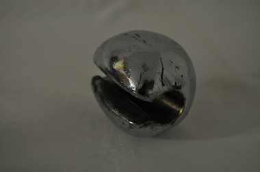
Auvard Speculum Weights
... Heavy solid metal cylinder - hollow with one section open (longitudinally) to fit onto handle of Auvard self retaining vaginal speculum....Scratched Heavy solid metal cylinder - hollow with one section open (longitudinally) to fit onto handle of Auvard self retaining vaginal speculum. ...This medical / hospital instrument was used in the Tawonga District General Hospital which was built in the 1950s specifically for the increase in population due to the Kiewa Hydro Electric Scheme.Historical: Shows the development of scientific hospital equipment. Provenance - Used in the Tawonga District General Hospital which was remote and therefore required good equipment. Good condition and good interpretation capacityHeavy solid metal cylinder - hollow with one section open (longitudinally) to fit onto handle of Auvard self retaining vaginal speculum.Scratchedmedical equipment. hospital equipment. tawonga. mt beauty. medical. hospital. nurse. doctor. medical instrument. weight. auvard. speculum.