Showing 7 items matching "longview"
-
 Whitehorse Historical Society Inc.
Newspaper - Article, Longview, 8/02/1994
... Longview......Longview...'View of Melbourne's harbor', article on 'Longview', built 1895 for the Morton family, at 21 Warrigal Road, Surrey Hills, Progress Press, 8 February 1994....Longview Newspaper Article ...'View of Melbourne's harbor', article on 'Longview', built 1895 for the Morton family, at 21 Warrigal Road, Surrey Hills, Progress Press, 8 February 1994.krivanek, ivo, morton family, longview, warrigal road, surrey hills, auctions -
 Hume City Civic Collection
Container - Bottle, wine, LONGVIEW CREEK/SUNBURY, 1994
... LONGVIEW CREEK/SUNBURY...On the front there is a map impression of Longview Gorge in Sunbury. On the back there is geographical and historical information about the vineyard. ...Front label: " LONGVIEW CREEK / SUNBURY / PINOT NOIR / 1994 / Produce of Australia"; " S A A 5300" embossed on the glass around the base of the bottle....The vineyard was planted in 1992. wines wineries longview creek vineyard longview gorge parker joan winemakers hodgson david ron george evans collection 1990s Front label: " LONGVIEW CREEK / SUNBURY / PINOT NOIR / 1994 / Produce of Australia"; " S A A 5300" embossed on the glass around the base of the bottle. ...The bottle was donated to the museum by Ron and Joan Parker for use in the exhibition ' A history of the Vineyards in Sunbury' held in the George Evans Museum in 1996. The vineyard was planted in 1992.Conventional bronze green glass bottle with indented base. Cream, gold & maroon printed labels. On the front there is a map impression of Longview Gorge in Sunbury. On the back there is geographical and historical information about the vineyard. There is black cap with a thin gold band at its base which covers the neck and opening of the bottle.Front label: " LONGVIEW CREEK / SUNBURY / PINOT NOIR / 1994 / Produce of Australia"; " S A A 5300" embossed on the glass around the base of the bottle.wines, wineries, longview creek vineyard, longview gorge, parker, joan, winemakers, hodgson, david, ron, george evans collection, 1990s -
 Kew Historical Society Inc
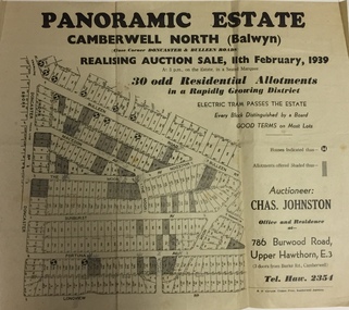
Plan - Subdivision Plan, Panoramic Estate, Camberwell North (Balwyn), 1939, 1939
... Subdivision plan advertised as the Panoramic Estate, Balwyn, showing lots for sale in the following streets: Bulleen Road, Macedon Avenue, The Moor, Sunburst Avenue, Doncaster Road, Fortuna Avenue, Longview Road, The Nook, and Touring Avenue....Kew Historical Society Inc Kew Court House 188 High Street Kew melbourne Subdivision plan advertised as the Panoramic Estate, Balwyn, showing lots for sale in the following streets: Bulleen Road, Macedon Avenue, The Moor, Sunburst Avenue, Doncaster Road, Fortuna Avenue, Longview Road, The Nook, and Touring Avenue. subdivision plans - balwyn (vic) panoramic estate - camberwell north - balwyn (vic) Nil Single page subdivision plan of the Panoramic Estate in Camberwell North (Balwyn); offered for sale in 1939 Panoramic Estate, Camberwell North (Balwyn), 1939 Plan Subdivision Plan ...Subdivision plan advertised as the Panoramic Estate, Balwyn, showing lots for sale in the following streets: Bulleen Road, Macedon Avenue, The Moor, Sunburst Avenue, Doncaster Road, Fortuna Avenue, Longview Road, The Nook, and Touring Avenue.Single page subdivision plan of the Panoramic Estate in Camberwell North (Balwyn); offered for sale in 1939Nilsubdivision plans - balwyn (vic), panoramic estate - camberwell north - balwyn (vic) -
 Kew Historical Society Inc
Plan - Subdivision Plan, Jas R Mathers Son & McMillan, Camberwell City Heights, 1922
... Area covered: Doncaster Road, Mountainview Road, Panoramic Road, Cityview Road, Longview Road, Riverview Road, Hillview Road, Bulleen Road. ...Area covered: Doncaster Road, Mountainview Road, Panoramic Road, Cityview Road, Longview Road, Riverview Road, Hillview Road, Bulleen Road. ..."Following the 1919 amalgamation of suburban tramway trusts, an electrified tram service extended along Doncaster Road. Housing estates such as the 1919 Balwyn Park Estate, 1922 Hillcrest Estate and the Camberwell City Heights Estate, also 1922, quickly followed. These estates were built over by expansive suburban villas, set in fine gardens and along tree-lined streets. North Balwyn, largely constructed since 1933, was typified by even grander houses, many of them in the 'ocean liner' style and seen at their most distinctive in the Riverview Estate." (Source; 'Balwyn' in eMelbourne)Portions of subdivision plan mounted on both sides of cardboard sheet. Coloured pink, probably to show allotments sold. Area covered: Doncaster Road, Mountainview Road, Panoramic Road, Cityview Road, Longview Road, Riverview Road, Hillview Road, Bulleen Road. Includes location diagram showing railway lines and existing and proposed tram routes.Cardboard backing has advertisement for "Tillock's soluble coffee"subdivision plans -- camberwell (vic.), camberwell city heights subdivision -
Surrey Hills Historical Society Collection
Photograph, Church of England Boys' Society at Mornington, Dec-16
... XMAS CAMP MORNINGTON 1916 / Property now owned by MYERS" Centre: "STAN SMITH / 6 LONGVIEW ROAD / NTH BALWYN"...XMAS CAMP MORNINGTON 1916 / Property now owned by MYERS" Centre: "STAN SMITH / 6 LONGVIEW ROAD / NTH BALWYN" Black and white photo of members of the Church of England Boys' Society on holiday at Mornington in 1916. ...An accompanying note reads: " SURREY HILLS CHURCH OF ENGLAND BOYS SOCIETY HOLIDAYS AT MORNINGTON 1916 / THOSE IN PHOTO:- / BACK ROW FROM LEFT:- / ERIC COLLINS / WALTER FROGLEY / REG DAY / H. (BERT) HUNT / CENTRE / FRANK SMITH / ROY SMITH / FRONT / STAN SMITH / ERIC SIMPSON / 1916."Black and white photo of members of the Church of England Boys' Society on holiday at Mornington in 1916. They are standing in front of a beach box and are identified as: Back row from left: Eric Collins, Walter Frogley, Reg Day, H (Bert) Smith Middle row: Frank Smith, Roy Smith Front row: Stan Smith, Eric SimpsonBlack and white photo - original and copy by Ken hall which measures 7" x 10"; original is mounted on maroon card.Front top of original in pen: " C.E.B.S. Camp Mornington 1916 / Xmas" Diagonally across front bottom RH cnr in pen "Yours truly / H.W.L. Hunt / 1917" Back top in ink: "C.E.B.S. XMAS CAMP MORNINGTON 1916 / Property now owned by MYERS" Centre: "STAN SMITH / 6 LONGVIEW ROAD / NTH BALWYN"church of england boys' society, sports and recreations, swimming, bathing costume, simpson, eric collins, walter frogley, reg day, bert hunt, herbert hunt, frank smith, roy smith, eric simpson, stan smith, 1910-1919, mornington -
 Ringwood and District Historical Society
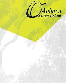
Document - Land Sale Folder, Auburn Grove Estate Ringwood East - 2011-2013
... Estate plan includes Auburn Grove off Longview Road and adjoining Tintern Grammar School, Ringwood East, Vic. ...Ringwood and District Historical Society 125A Warrandyte Road Ringwood North melbourne Estate plan includes Auburn Grove off Longview Road and adjoining Tintern Grammar School, Ringwood East, Vic. ...Folder containing flyers and multi-fold colour pamphlet advertising Auburn Grove Estate with maps and layout of subdivision and photographs of area. Flyers for First Release Auction 6 August, 2011 enclosed, and Second and Final Release Private Sale flyer with copy showing handwritten sale prices.Estate plan includes Auburn Grove off Longview Road and adjoining Tintern Grammar School, Ringwood East, Vic. Agents - Carter Real Estate, 90 Maroondah Highway, Ringwood Vic 3134. Phone 9870 6211 Fax 9870 6024. Accompanying folder includes handwritten auctioneer's notation (Richard Carter) on the name, that Auburn Grove Estate is adjacent to Tintern Farm - Tintern School originally having moved to Ringwood East from Auburn, Melbourne (1953). -
 Ringwood and District Historical Society
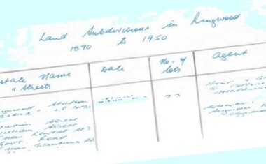
Document - Research Notes, Richard Carter, Land Subdivisions in Ringwood 1890-1950
... (1920) Eastfield Road, Longview Road, Pleasant Rise, The Mount Pg10 ELECTRIC RAILWAY ESTATE RINGWOOD LP9473 (1922) Campbell Street, Myrtle Avenue, George Street (now Tudor Court), Henry Street (now Myrtle Avenue), Williams Grove (now Lena Grove) Pg11 RINGWOOD PARK ESTATE LP7884 (1922 - two stages) Wonga Road (now Loughnan Road), William Street, Andrew Street, Harrison Street Pg12 HEATHMONT STATION ESTATE LP11009 (Date? ...(1920) Eastfield Road, Longview Road, Pleasant Rise, The Mount Pg10 ELECTRIC RAILWAY ESTATE RINGWOOD LP9473 (1922) Campbell Street, Myrtle Avenue, George Street (now Tudor Court), Henry Street (now Myrtle Avenue), Williams Grove (now Lena Grove) Pg11 RINGWOOD PARK ESTATE LP7884 (1922 - two stages) Wonga Road (now Loughnan Road), William Street, Andrew Street, Harrison Street Pg12 HEATHMONT STATION ESTATE LP11009 (Date? ...Handwritten table listing main local pre-1950s subdivisions in the Ringwood area, with estate names, streets, number of allotments for sale, and where known, vendor agent, LP (Lodged Plan) title registration number, and auction/sale date, some with sale price.Pg1 RINGWOOD STATION ESTATE LP3070 (Year?) Station Street, William Street (now Kendall Street), Wantirna Road, Station Street Pg1 RINGWOOD TOWNSHIP ESTATE LP5577 (1913) Station Road (now Warrandyte Road), Pratt Street (part now Aird Street), Whitehorse Road Pg2 RINGWOOD ORCHARD ESTATE LP4315 (1914) Brysons Road, Hillcrest Road, Anzac Avenue, Sulva Road Pg3 RINGWOOD RAILWAY ESTATE LP7522 (1918) Whitehorse Road (now Mount Dandenong Road), Dublin Road, Freeman Street, Patterson Street, Bona Street Pg4 THE RINGWOOD ESTATE LP7578 (1919) Warrandyte Road, Hobart Street, Paxton Street, Arnold Street Pg5 GARDEN FARMS ESTATE (LP?) (1919) Canterbury Road, Armstrong Road, Bungalook Road, Orchard Road, Bayswater Road (now Mountain Highway) Pg6 THE RINGWOOD ESTATE (SECOND SUB-DIVISION) LP7604 (1919) Warrandyte Road, Tamar Street, Derwent Street, Mersey Street Pg7 RINGWOOD STATION ESTATE LP7703 (1919) Bedford Road, Williams Grove (now Lena Grove) Pg8 RINGWOOD TOWNSHIP ESTATE LP8198 (1919) Wantirna Road, Ellison Street, Haig Street, Greenwood Avenue Pg9 EASTFIELD ESTATE (LP?) (1920) Eastfield Road, Longview Road, Pleasant Rise, The Mount Pg10 ELECTRIC RAILWAY ESTATE RINGWOOD LP9473 (1922) Campbell Street, Myrtle Avenue, George Street (now Tudor Court), Henry Street (now Myrtle Avenue), Williams Grove (now Lena Grove) Pg11 RINGWOOD PARK ESTATE LP7884 (1922 - two stages) Wonga Road (now Loughnan Road), William Street, Andrew Street, Harrison Street Pg12 HEATHMONT STATION ESTATE LP11009 (Date? - after 1922) Lisgoold Street, Viviani Crescent, Balrour Avenue, Station Street (now part Heathmont Road and part Wainui Street) Pg13 RINGWOOD RAILWAY ESTATE LP10507 (1923) Whitehorse Road, Sherbrooke Avenue, Burwood Avenue, Bonview Avenue, Heatherbrae Avenue, Grant Crescent Pg14 GARDEN HOMES ESTATE (LP?) (1923) Mullum Road, The Centreway, Wattle Crescent (now Wattle Avenue) Reserve Crescent (now Reserve Road) Pg15 DUBLIN ROAD ESTATE LP11993 (1923) Alexandra Road, Vonadawn Avenue, Green Street, Wood Street, Howard Avenue, Bedford Road, Dublin Road Pg16 CARLINGA ESTATE RINGWOOD LP9620 (1923) Bourke Street, Bond Street, Ringwood Street Pg17 PRATT'S JUNCTION ESTATE (LP?) (1923) Junction Street, Georges Road, Oliver Street, Whitehorse Road Pg18 EAST RINGWOOD ESTATE LP10492 (1923) Bona Street, Patterson Street, Miller Grove, Fairview Avenue, Eastfield Road, Whitehorse Road (now Mount Dandenong Road) Pg19 COLEMAN'S HEATHMONT ESTATE LP9974 (1923) Canterbury Road, Bedford Road, Alvena Crescent, Coleman Street, Leonard Street (now Royal Avenue) Pg20 RINGWOOD HEIGHTS ESTATE LP10506 (1924) Whitehorse Road, Bonview Avenue, Grant Crescent, Hillcrest Avenue, Heatherbrae Avenue, Margaret Street, Mary Street Pg21 EAST RINGWOOD STATION ESTATE LP10551 (1924) Knaith Road, Wenwood Street, Lois Street, Victoria Street, Station Street (now Railway Avenue) Pg22 GRAND VIEW ESTATE LP11019 (1924) Whitehorse Road, Rupert Street, Herbert Street, Leonard Street Pg23 RINGWOOD RAILWAY ESTATE & RINGWOOD HEIGHTS ESTATE - FINAL SECTIONS LP10506 & LP10507 (1924) Whitehorse Road, Sherbrooke Avenue, Burwood Avenue, Bonview Avenue, Heatherbrae Avenue, Margaret Street, Mary Street, Grant Crescent Pg24 RINGWOOD EAST ELECTRIC STATION ESTATE (LP?) (1924) Railway Parade (now Patterrson Street), Federal Road, Howship Avenue (part now French Street), Dublin Road, Rosedale Crescent Pg25 BEDFORD PARK (now Ringwood Secondary College) (LP?) (1924) Bedford Road, Adams Street, Anderson Street, Joyce Street, Graham Road Pg26 CROWN JEWEL ESTATE LP11645 (Private sales after 1924) Mount Dandenong Road, Mirabel Avenue, Valda Avenue, Evon Avenue, Velma Grove Pg27 GRAND CENTRAL ESTATE LP10917 (1925) Heathmont Road, Great Ryrie Street, Douglas Street, Garden Street, Bellevue Avenue Pg28 RINGWOOD (unnamed estate - 1926) Nelson Street, Seymour Street, Whitehorse Road Pg29 EAST RINGWOOD RAILWAY STATION ESTATE (YEAR? - 25 shops 60 villas) Railway Avenue, Dublin Road, Lawrence Grove, Stanley Avenue, Knaith Road Pg30 CHARM VIEW ESTATE (LP?) (year? - after 1926) Canterbury Road, Heathmont Road, Dickasons Road, Bennjett Avenue, Orchid Street Pg31 SUNBEAM ESTATE LP12150 (Circa 1925) Govt Road (now Old Lilydale Road), Sunbeam Avenue, Holland Road, Everard Street (now Everard Road) Pg32 FAIRVIEW ESTATE EAST RINGWOOD LP10853 (Circa 1924) Eastfield Road, Patterson Street, Margaret Street (now Short Street) Pg33 EAST RINGWOOD TOWNSHIP ESTATE LP3025 (Circa 1924 - 35 allotments) Mount Dandenong Road, Grey Street, Eastfield Road Pg34 EAST RINGWOOD TOWNSHIP ESTATE LP3025 (Circa 1924 - 49 allotments) and STATE SCHOOL ESTATE (26 allotments) and EAST RINGWOOD STATION ESTATE (14 shop sites) Mount Dandenong Road, Grety Street, Dunn Street, Eastfield Road, King Street, Holland Road, Dublin Road, Patterson Street, Bona Street Pg35 EAST RINGWOOD CENTRAL ESTATE LP17004 (1948) Knaith Road, Shasta Avenue, Talofa Avenue, Russet Road, Dublin Road Pg36 WARE ESTATE LP43360 (1958) Ware Crescent, Davey Drive, Grey Road (now Grey Street), Mount Dandenong Road Pg37 Lot 57 Kendall Street LP3070 (1939) £75.0.0 Pg37 Lot 14 LP7346 (year?) £225 Pg37 Lot 8 WHITE HORSE ESTATE LP14010 (year?) Maroondah Hwy, Seymour Street £98.9.0 Pg37 Lots 4-14 incl. LP10902 (year?) £300 Pg37 Lots 69&70 LP2216 (1939) Bedford Road, Pitt Street £500 Pg37 Lots 60&70 LP2216 (year?) £460 Pg37 MOUNTAIN VIEW ESTATE LP10902 (1936) Lots 1&2, 19-22 Wantirna Road, Daisy Street £50 Pg38 RAILWAY STATION ESTATE RINGWOOD EAST LP7522 (1925) Lots 16 to 19 £250 Pg38 RINGWOOD PARK ESTATE (LP?) (1924) Lot 112 Munro Street £230 Pg38 RINGWOOD TOWNSHIP ESTATE (LP?) (1925) Lot 57 Wantirna Road £850 Pg38 ELECTRIC RAILWAY ESTATE LP9473 (1925) Lot 98 & 99 £180 (30/- foot) Pg38 ELECTRIC RAILWAY ESTATE LP9473 (year?) Lot 100 £233.12.6 incl improvements (£2.12.6 foot) Pg38 Lot 22&23 Bedford Road Heathmont (LP & year?) £675 incl improvements Pg39 Lot 9 Mullum Mullum Road LP8221 (1923) £150 Pg39 Lot 27 Haig Street LP8198 (1925) £825 Pg39 Lot 56 Haig Street cnr Wantirna Road LP8198 (1923) £171 Pg39 Lots 3 & 4 Loughnan Road LP9626 (192?) £147 Pg39 Lots 98 & 99 Myrtle Avenue LP9473 (1925) £180 Pg39 Lots 80 & 81 Myrtle Avenue LP9473 (1929) £150 Pg39 Lot 30 Sherbrooke Avenue LP10507 (1926) £700 incl improvements Pg40 Lot 10 (year?) LP7703 £750 Pg40 Lot 36 (year?) LP7522 £25 Pg40 Lot 38 Pitt Street LP2216 (year?) £350 Pg40 Lot 7 Dublin Road cnr Green Street LP11993 (year?) £300