Showing 617 items matching "lookouts"
-
 Buninyong & District Historical Society
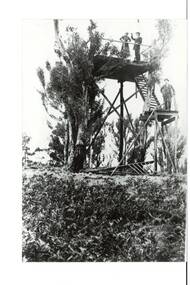
Photograph - B/W photograph, Original Look out Tower Mt. Buninyong
... View of original Lookout tower at Mt. Buninyong early 1900s...View of the original Lookout tower on Mt Buninyong circa 1900...Lookout tower, Mt. Buninyong...Buninyong View of the original Lookout tower on Mt Buninyong circa 1900 Original Look out Tower Mt. ...View of original Lookout tower at Mt. Buninyong early 1900sThe structure was the earliest platform tower built on Mount Buninyong in the early 20th century as part of the development of the mount into a popular recreation areaView of the original Lookout tower on Mt Buninyong circa 1900Lookout tower, Mt. Buninyonglandscape, mt buninyong, civil engineering -
 Halls Gap & Grampians Historical Society
Photograph, C 1960s (?)
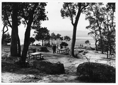
... ...lookouts...People at the Boroka Lookout picnic area....Photo shows two men standing close to a picnic table in a picnic area near a lookout (Boroka Lookout). Two other people are standing at the wire fence of the lookout. ...Halls Gap & Grampians Historical Society Centennial Hall 117-119 Grampians Road Halls Gap grampians People at the Boroka Lookout picnic area. scenery lookouts Photo shows two men standing close to a picnic table in a picnic area near a lookout (Boroka Lookout). ...People at the Boroka Lookout picnic area.Photo shows two men standing close to a picnic table in a picnic area near a lookout (Boroka Lookout). Two other people are standing at the wire fence of the lookout. A valley and distant ranges can be seen in the background.scenery, lookouts -
 Halls Gap & Grampians Historical Society
Photograph - B/W, C 1960s
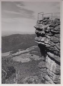
... ...Lookouts...Lookout is known as 'The Pinnacle'. Valley is the Fyans Valley....On back notes "bellfield' but neither Bellfield Peak or Bellfield lookout can be seen....SCENERY Lookouts On back notes "bellfield' but neither Bellfield Peak or Bellfield lookout can be seen. ...Lookout is known as 'The Pinnacle'. Valley is the Fyans Valley.Photo shows rocky outcrop surrounded by a wire fence and overlooking a valley with roads,some cleared areas and buildings. The Mt. William range can be seen middle left in the photo.On back notes "bellfield' but neither Bellfield Peak or Bellfield lookout can be seen.scenery, lookouts -
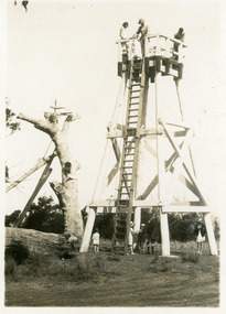
 Buninyong & District Historical Society
Photograph - B/W photograph, On the top of the Lookout Tower Mt. Buninyong
... On the top of the Lookout Tower Mt. Buninyong...View of people at the top of the second Lookout tower on Mt. Buninyong 1938...Four people on top of the second Mt. Buninyong Lookout Tower in 1938...Jose Cody, Faith Murray, Lou Prunty and Lou Gleeson at top of Buninyong lookout 1938...Buninyong Lookout Tower in 1938 On the top of the Lookout Tower Mt. ...View of people at the top of the second Lookout tower on Mt. Buninyong 1938The structure was the second built on Mount Buninyong in the early 20th century as part of the development of the mount into a popular recreation areaFour people on top of the second Mt. Buninyong Lookout Tower in 1938Jose Cody, Faith Murray, Lou Prunty and Lou Gleeson at top of Buninyong lookout 1938mt buninyong, people, lookout tower -
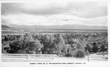 Stawell Historical Society Inc
Photograph, Panorama of Stawell from Big Hill towards the Grampians. Murray Views No. 25
... The Grampians from Lookout Post 1939...Photo taken from the Grampians Lookout, Stawell. Showing The Grampians in the distance and trees filling most of the foreground....The Grampians from Lookout, Stawell. Vic....The Grampians from Lookout, Stawell. Vic. Photo taken from the Grampians Lookout, Stawell. ...Panorama of Stawell from Big Hill Murray Views No. 25. The Grampians from Lookout Post 1939Photo taken from the Grampians Lookout, Stawell. Showing The Grampians in the distance and trees filling most of the foreground.Murray View No. 25. The Grampians from Lookout, Stawell. Vic.stawell, panorama -
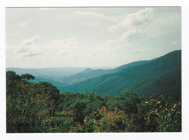
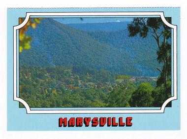 Marysville & District Historical Society
Postcard (item) - Colour postcard, Scancolor (Australia) Pty Ltd, Marysville, Pre 2009
... A colour photograph of the view of Marysville from Cumberland lookout....A colour photograph of the view of Marysville in Victoria from Cumberland lookout....MARYSVILLE Victoria - Australia View to Marysville township from Cumberland/ lookout. scancolor Australia (03) 555 1944 CS 4064...Marysville & District Historical Society 39 Darwin Street Marysville yarra-valley-and-the-dandenong-ranges A colour photograph of the view of Marysville from Cumberland lookout. A colour photograph of the view of Marysville from Cumberland lookout. ...A colour photograph of the view of Marysville from Cumberland lookout.A colour photograph of the view of Marysville from Cumberland lookout. This postcard was produced by Scancolor Australia as a souvenir of Marysville.MARYSVILLE Victoria - Australia View to Marysville township from Cumberland/ lookout. scancolor Australia (03) 555 1944 CS 4064marysville, cumberland lookout, victoria, scancolor australia, postcard, souvenir -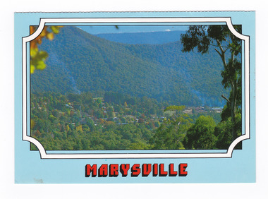
 Buninyong & District Historical Society
Photograph - B/W photograph, Lookout Tower Mt. Buninyong
... Lookout Tower Mt. Buninyong...View of the steps of the second Lookout tower at Mt. Buninyong in 1938. The tower was reconstructed on Mount Buninyong in 1928 after it was removed from Bendigo. ...View of the lower stairs of the second lookout tower built on Mt. Buninyong...Lou Prunty and Lou Gleeson descending lookout steps Kay and Jose' Cody on bottom...Buninyong Lookout Tower Mt. Buninyong Photograph B/W photograph ...View of the steps of the second Lookout tower at Mt. Buninyong in 1938. The tower was reconstructed on Mount Buninyong in 1928 after it was removed from Bendigo. In February 1980 it was moved back to BendigoThe structure was the second built on Mount Buninyong in the early 20th century as part of the development of the mount into a popular recreation areaView of the lower stairs of the second lookout tower built on Mt. BuninyongLou Prunty and Lou Gleeson descending lookout steps Kay and Jose' Cody on bottomlandscape, mt buninyong, civil engineering -
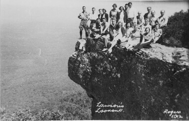
 Halls Gap & Grampians Historical Society
Photograph, C 1930s/40s
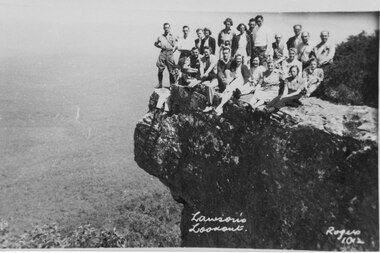
... ...lookouts...This is a photo of a group of tourists on Lawson's Lookout, taken by Gilbert Rogers, a well known Hall's Gap photographer...."Lawson's Lookout Rogers 1012" inscribed into lower part of photo....This is a photo of a group of tourists on Lawson's Lookout, taken by Gilbert Rogers, a well known Hall's Gap photographer. scenery lookouts people tourists "Lawson's Lookout Rogers 1012" inscribed into lower part of photo. ...C 1930's/40's. This is a photo of a group of tourists on Lawson's Lookout, taken by Gilbert Rogers, a well known Hall's Gap photographer.The photo shows a group of twenty-one men and women posed on a rocky outlook. A bushy valley can be seen below with a road winding into the distance."Lawson's Lookout Rogers 1012" inscribed into lower part of photo.scenery, lookouts, people, tourists -
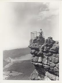
 Halls Gap & Grampians Historical Society
Photograph - B/W
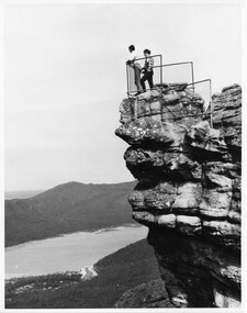
... ...Lookouts...The Pinnacle Lookout with Fyans Valley below. Bellfield Hotel is visible in the lower left of the picture, cleared land is apparent in the middle of the picture....Man standing at a lookout on a rocky outcrop overlooking a valley. ...SCENERY Lookouts Man standing at a lookout on a rocky outcrop overlooking a valley. ...The Pinnacle Lookout with Fyans Valley below. Bellfield Hotel is visible in the lower left of the picture, cleared land is apparent in the middle of the picture.Man standing at a lookout on a rocky outcrop overlooking a valley. Guide rails surround part of the outcop. A mountain range is opposite.scenery, lookouts -
 Halls Gap & Grampians Historical Society
Photograph - B/W, C 1960s (?)
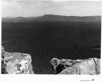
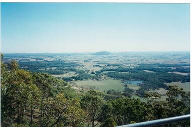
... ...Lookouts...This photo is a view from the road at Reed's Lookout....The photo shows the view from beside a road (the road at Reed's Lookout), across bushland to a large reservoir (Lake Wartook). ...Halls Gap & Grampians Historical Society Centennial Hall 117-119 Grampians Road Halls Gap grampians This photo is a view from the road at Reed's Lookout. SCENERY Lookouts 'Forests Commission, Victoria' inscribed on bottom, right of border. ...This photo is a view from the road at Reed's Lookout.The photo shows the view from beside a road (the road at Reed's Lookout), across bushland to a large reservoir (Lake Wartook). There is a range of peaks in the background. The road forms the foreground.'Forests Commission, Victoria' inscribed on bottom, right of border. 'Publicity & Public relations Branch, When reproducing please Acknowledge Forests Commission, Victoria, Negative No. 322-34' stamped on back.scenery, lookouts -
 Halls Gap & Grampians Historical Society
Photograph - B/W, C 1960s (?)
... ...Lookouts...The photo is taken from Reed's Lookout....The photo shows the view across a valley from a (Reed's Lookout). The foreground is two large rock platforms. ...Halls Gap & Grampians Historical Society Centennial Hall 117-119 Grampians Road Halls Gap grampians The photo is taken from Reed's Lookout. SCENERY Lookouts 'Forests Commission, Victoria' inscribed on bottom, right of border. ...The photo is taken from Reed's Lookout.The photo shows the view across a valley from a (Reed's Lookout). The foreground is two large rock platforms. A reservoir (Moora Moora) and ranges can be seen in the background. Roads can be seen in the valley in the foreground.'Forests Commission, Victoria' inscribed on bottom, right of border. 'Publicity & Public relations Branch, When reproducing please Acknowledge Forests Commission, Victoria, Negative No. 322-23' stamped on back.scenery, lookouts -
 Marysville & District Historical Society
Postcard (item) - Colour postcard, Nucolorvue Productions Pty. Ltd, Marysville Victoria, Pre 2009
... A colour photograph of the view of Marysville in Victoria from Sheehan's Lookout....A colour photograph of the view of Marysville in Victoria from Sheehan's Lookout....View of Marysville from Sheehan's Lookout. NU-COLOR-VUE/ OF/ AUSTRALIA AFFIX / STAMP/ HERE/ 17 MA007/ NCV 4938 ADDRESS/ POSTCODE COPYRIGHT/ Nucolorvue Productions Pty. ...Ltd. as a souvenir of Marysville. marysville sheehan's lookout victoria nucolorvue productions postcard souvenir View of Marysville from Sheehan's Lookout. ...A colour photograph of the view of Marysville in Victoria from Sheehan's Lookout.A colour photograph of the view of Marysville in Victoria from Sheehan's Lookout. This postcard was produced by Nucolorvue Productions Pty. Ltd. as a souvenir of Marysville.View of Marysville from Sheehan's Lookout. NU-COLOR-VUE/ OF/ AUSTRALIA AFFIX / STAMP/ HERE/ 17 MA007/ NCV 4938 ADDRESS/ POSTCODE COPYRIGHT/ Nucolorvue Productions Pty. Ltd.,/ Telephone: (03) 560-1788/ Made in Australiamarysville, sheehan's lookout, victoria, nucolorvue productions, postcard, souvenir -
 Marysville & District Historical Society
Postcard (item) - Colour postcard, Nucolorvue Productions Pty. Ltd, Mystic Mountains-Marysville, Pre 2009
... A colour photograph of the view of the mountains surrounding Marysville in Victoria from Nicholl's Lookout....A colour photograph of the view of the mountains surrounding Marysville in Victoria from Nicholl's Lookout....NICHOLS LOOKOUT/ Marysville Victoria NU-COLOR-VUE/ AUSTRALIA'S NATIONAL POSTCARD COMPANY AFFIX/ STAMP/ HERE/ 17MA019/ NCV 9603 POSTCODE COPYRIGHT/ Nucolorvue Productions Pty. ...Marysville & District Historical Society 39 Darwin Street Marysville yarra-valley-and-the-dandenong-ranges A colour photograph of the view of the mountains surrounding Marysville in Victoria from Nicholl's Lookout. A colour photograph of the view of the mountains surrounding Marysville in Victoria from Nicholl's Lookout. ...A colour photograph of the view of the mountains surrounding Marysville in Victoria from Nicholl's Lookout.A colour photograph of the view of the mountains surrounding Marysville in Victoria from Nicholl's Lookout. The mountains surrounding Marysville are known as the Mystic Mountains and Nicoll's Lookout is on the Marysville-Wood's Point Road. The Marysville-Woods Point Road was originally part of the Yarra Track, constructed in the early 1860s to provide access between Healesville and the Woods Point Goldfields. Despite the steep terrain and engineering difficulties, the Yarra Track soon became a busy route used by pack horses, horse-drawn drays, and wagons. Today this sealed mountain road is a popular scenic drive between Marysville and Warburton. This postcard was produced by Nucolorvue Productions in Elwood, Victoria as a souvenir of Marysville.This postcard was produced by Nucolorvue Productions Pty. Ltd. as a souvenir of Marysville.NICHOLS LOOKOUT/ Marysville Victoria NU-COLOR-VUE/ AUSTRALIA'S NATIONAL POSTCARD COMPANY AFFIX/ STAMP/ HERE/ 17MA019/ NCV 9603 POSTCODE COPYRIGHT/ Nucolorvue Productions Pty. Ltd.,/ Telephone: (03) 560-1788/ Made in Australiamarysville, mystic mountains, nicholl's lookout, victoria, nucolorvue productions, postcard, souvenir, marysville-wood's point road, yarra track, healesville, mining, warburton -
 Halls Gap & Grampians Historical Society
Photograph - B/W, C 1960s
... ...Lookouts...Photo is of 'The Pinnacle' lookout with Lake Bellfield in the background flanked by the Mt. ...A lake with a dam wall and rock tiers cut into the hillside can be seen as well as cleared areas some buildings. the lookout is enclosed with a wire fence....Halls Gap & Grampians Historical Society Centennial Hall 117-119 Grampians Road Halls Gap grampians Photo is of 'The Pinnacle' lookout with Lake Bellfield in the background flanked by the Mt. ...Photo is of 'The Pinnacle' lookout with Lake Bellfield in the background flanked by the Mt. William range. the photo is typical of 'tourism' photos taken by the Victorian Railways.Photo shows a man and a woman on top of a rocky outcrop that overlook a valley. A lake with a dam wall and rock tiers cut into the hillside can be seen as well as cleared areas some buildings. the lookout is enclosed with a wire fence.scenery, lookouts -
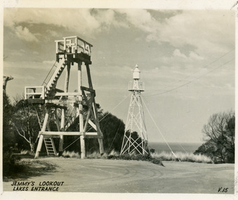
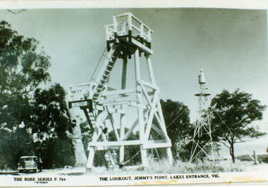 Lakes Entrance Historical Society
Photograph - Lookout tower Jemmy's Point, The Rose Series, 1950
... Old lookout tree in background appears to have some of the top missing. ...The Lookout Jemmy's Point Lakes Entrance...Old lookout tree in background appears to have some of the top missing. ...Identical copy 10 x 15Black and white photograph copied from a postcard showing timber lookout tower and signal beacon on Jemmy's Point. Old lookout tree in background appears to have some of the top missing. Lakes Entrance Victoria.The Lookout Jemmy's Point Lakes Entrancehistoric sites, navigation -
 Glenelg Shire Council Cultural Collection
Photograph - Photograph - Jones' Lookout, n.d
... Photograph of Jones Lookout, Glenelg River....Front: Sticker bottom left. 'Jones' Lookout Glenelg River' - pen...'Jones' Lookout Glenelg River' - pen Photograph of Jones Lookout, Glenelg River. ...Glenelg Shire Council records Portland Development Committee.Photograph of Jones Lookout, Glenelg River.Front: Sticker bottom left. 'Jones' Lookout Glenelg River' - penjones lookout, portland, scenery -
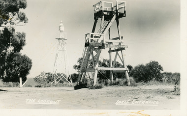
 Lakes Entrance Historical Society
Postcard - Lookout tower Jemmy's Point, Valentine Series, 1940
... Top of old standing lookout tree just visible....Jemmys Lookout Lakes Entrance...Top of old standing lookout tree just visible. Postcard Lookout tower Jemmy's Point Valentine Series ...Black and white small format postcard of the timber observation lookout at Jemmy's Point, Lakes Entrance, Victoria, showing the timber tower with observation deck, signal beacon on steel tower nearby. Top of old standing lookout tree just visible.Jemmys Lookout Lakes Entrancehistoric sites, navigation -
 Lakes Entrance Historical Society
Postcard - Lookout tower Jemmy's Point, Bulmer H D, 1950
... Black and white postcard of the timber lookout on Jemmy's Point, with the signal beacon on steel tower nearby. ...The Lookout, Lakes Entrance...Lakes Entrance Victoria, Postcard Lookout tower Jemmy's Point Bulmer H D ...Black and white postcard of the timber lookout on Jemmy's Point, with the signal beacon on steel tower nearby. Lakes Entrance Victoria,The Lookout, Lakes Entrancehistoric sites, navigation -
 Halls Gap & Grampians Historical Society
Photograph - Sepia
... ...Lookouts...Photo shows a group of people sitting on Lawson's lookout, original name for Reid's lookout....Halls Gap & Grampians Historical Society Centennial Hall 117-119 Grampians Road Halls Gap grampians PEOPLE Gilbert Rogers SCENERY Lookouts Photo shows a group of people sitting on Lawson's lookout, original name for Reid's lookout. ...Photo shows a group of people sitting on Lawson's lookout, original name for Reid's lookout.people, gilbert rogers, scenery, lookouts -
 Lakes Entrance Historical Society
Postcard - Lookout tower Jemmys Point, 1929
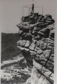
... Five people on ground, three on platform. Old Lookout Tree standing in background....On reverse, 'LookOut Jemmys Point, Lakes Entrance'...Five people on ground, three on platform. Old Lookout Tree standing in background. Postcard Lookout tower Jemmys Point ...Also, two enlargements, 10 x 15 cm, and one enlargement 17 x 25 cm, all purchasedSmall format postcard showing the first observation lookout erected on Jemmy's Point, Lakes Entrance, Victoria, showing a timber structure about 30 feet high with a fenced platform on top, narrow ladder leading straight to top from ground. Five people on ground, three on platform. Old Lookout Tree standing in background.On reverse, 'LookOut Jemmys Point, Lakes Entrance'historic sites, navigation -
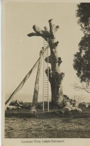 Lakes Entrance Historical Society
Postcard - Historic Lookout tree Jemmys Point Lakes Entrance c1925, H D Bulmer
... Black and white postcard of Lookout on Jemmys Point showing an old dead grey box tree trunk many limbs lying on ground near base trunk stabilized by two long poles straight ladder from ground to fork at top Lakes Entrance Victoria...Lookout Tree Lakes Entrance...Jetties Waterways Jemmys Point Lakes Entrance Topography Lookout Tree Lakes Entrance Black and white postcard of Lookout on Jemmys Point showing an old dead grey box tree trunk many limbs lying on ground near base trunk stabilized by two long poles straight ladder from ground to fork at top Lakes Entrance Victoria Postcard Historic Lookout tree Jemmys Point Lakes Entrance c1925 H D Bulmer ...Jemmys Point showing an old dead grey box tree trunk many limbs lying on ground near base trunk stabilized by two long poles straight ladder from ground to fork at top Lakes Entrance Victoria. This tree eventually fell down in 2024. East Gippsland shire have placed a garden bed around it.Black and white postcard of Lookout on Jemmys Point showing an old dead grey box tree trunk many limbs lying on ground near base trunk stabilized by two long poles straight ladder from ground to fork at top Lakes Entrance VictoriaLookout Tree Lakes Entrancejetties, waterways, jemmys point lakes entrance, topography -
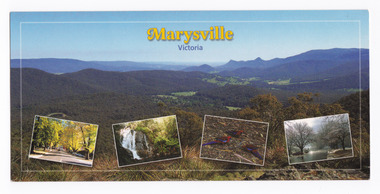 Marysville & District Historical Society
Postcard (item) - Colour postcard, Imagine That! Promotions, Marysville-Victoria, 2002
... A colour photograph of the view from Keppel Lookout of Marysville and the Cathedral Range along with photographs of the main street in Marysville, Steavenson Falls, birdlife and snow in Marysville. ... A colour photograph of the view from Keppel Lookout of Marysville and the Cathedral Range along with photographs of the main street in Marysville, Steavenson Falls, birdlife and snow in Marysville...../ Featured is (Main Picture) Marysville with the picturesque Cathedral Range in the back-/ ground as seen from Keppel Lookout. From the left is Marysville's main street during/ Autumn, Steavenson Falls, Crimson Rosellas and Marysville covered by a low snowfall. ...Promotions as a souvenir of Marysville. marysville keppel lookout cathedral range murchison street steavenson falls scarlet rosella snow imagine that! ...A colour photograph of the view from Keppel Lookout of Marysville and the Cathedral Range along with photographs of the main street in Marysville, Steavenson Falls, birdlife and snow in Marysville. A colour photograph of the view from Keppel Lookout of Marysville and the Cathedral Range along with photographs of the main street in Marysville, Steavenson Falls, birdlife and snow in Marysville. This postcard was produced by Imagine That! Promotions as a souvenir of Marysville.Marysville is a beautiful small country town approximately 100 km's from Melbourne. It is/ well known for its amazing autumn colours, prolific wildlife and is only half an hours drive/ from Lake Mountain, Australia's largest Cross Country Skiing Resort./ Featured is (Main Picture) Marysville with the picturesque Cathedral Range in the back-/ ground as seen from Keppel Lookout. From the left is Marysville's main street during/ Autumn, Steavenson Falls, Crimson Rosellas and Marysville covered by a low snowfall. Imagine That!/ Post Cards Imagine That! Promotions/ Country Victoria Collection/ Landscape 1/ c 2002/ Ph: (03) 5966 8523 Fax: (03) 5966 8458 Mob: 0418 593 534 Place/ Stamp/ Heremarysville, keppel lookout, cathedral range, murchison street, steavenson falls, scarlet rosella, snow, imagine that! promotions, postcard, souvenir -
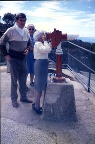 Vision Australia
Photograph - Image, Bill Ford, Miss Turner and Mrs Davies view Myrtleford from a lookout, 1985
... Bill Ford, Miss Turner and Mrs Davies view Myrtleford from a lookout...Here Bill Ford, Miss Turner and Mrs Davies view the beauty of Myrtleford from a lookout....1 x colour photograph of people at lookout...Here Bill Ford, Miss Turner and Mrs Davies view the beauty of Myrtleford from a lookout. Kelaston home (Ballarat) Association for the Blind Bill Ford 1985 Myrtleford holiday 1 x colour photograph of people at lookout Bill Ford, Miss Turner and Mrs Davies view Myrtleford from a lookout Photograph Image ...Trips away were a highlight for some day centre participants. Here Bill Ford, Miss Turner and Mrs Davies view the beauty of Myrtleford from a lookout.1 x colour photograph of people at lookout1985 Myrtleford holidaykelaston home (ballarat), association for the blind, bill ford -
 Lakes Entrance Historical Society
Book, Naumenko, David John, The Lookout Tree, 1998
... The Lookout Tree...Lookouts...Research, interpretation and management recommendations for the Lookout Tree, Jemmy's Tree, Lakes Entrance, East Gippsland, Victoria, by Forestec student....The Lookout Tree Book Naumenko, David John ...Research, interpretation and management recommendations for the Lookout Tree, Jemmy's Tree, Lakes Entrance, East Gippsland, Victoria, by Forestec student.lookouts, tourism, ships and shipping -
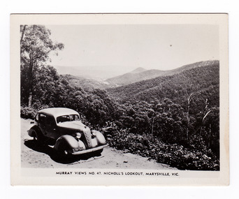 Marysville & District Historical Society
Photograph (item) - Black and white photograph, Murray Views, Murray Views No. 47. Nicholl's Lookout, Marysville, Vic, Post 1929
... Murray Views No. 47. Nicholl's Lookout, Marysville, Vic....An early black and white photograph of the view of Marysville taken from Nicholl's Lookout....An early black and white photograph of the view of Marysville taken from Nicholl's Lookout....Nicholl's Lookout is situated on the Marysville-Wood's Point Road. ...An early black and white photograph of the view of Marysville taken from Nicholl's Lookout.An early black and white photograph of the view of Marysville taken from Nicholl's Lookout. Nicholl's Lookout is situated on the Marysville-Wood's Point Road. The Marysville-Woods Point Road was originally part of the Yarra Track, constructed in the early 1860s to provide access between Healesville and the Woods Point Goldfields. Despite the steep terrain and engineering difficulties, the Yarra Track soon became a busy route used by pack horses, horse-drawn drays, and wagons. Today this sealed mountain road is a popular scenic drive between Marysville and Warburton. This photograph was produced by Murray Views in Gympie, Queensland as a souvenir of Marysville. nicholl's lookout, marysville, victoria, photograph, murray views, souvenir, marysville-wood's point road, yarra track, mining, warburton -
 Halls Gap & Grampians Historical Society
Photograph - B/W
... ...Lookouts...The two men are standing at The Pinnacle Lookout, overlooking Bellfield Reservoir in the Fyans Valley...Halls Gap & Grampians Historical Society Centennial Hall 117-119 Grampians Road Halls Gap grampians The two men are standing at The Pinnacle Lookout, overlooking Bellfield Reservoir in the Fyans Valley SCENERY Lookouts Two men standing behind cyclone wire three panel fence. ...The two men are standing at The Pinnacle Lookout, overlooking Bellfield Reservoir in the Fyans ValleyTwo men standing behind cyclone wire three panel fence. Man on left is wearing a white shirt and long pants, the other in a checked shirt and long dark pants. They are on top of a large rocky outcrop overlooking a body of water and another mountain range scenery, lookouts -
 Warrnambool and District Historical Society Inc.
Work on paper - Project, Cannon Hill 1939, 1939
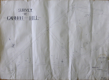
... A map thought to be a school project depicting the layout of Cannon Hill, a popular lookout in Warrnambool....A map thought to be a school project depicting the layout of Cannon Hill, a popular lookout in Warrnambool....Checked 13/02/1939 T E Wingrove A map thought to be a school project depicting the layout of Cannon Hill, a popular lookout in Warrnambool. Cannon Hill 1939 Work on paper Project ...A map thought to be a school project depicting the layout of Cannon Hill, a popular lookout in Warrnambool.A locally drawn map indicative of school work from the 1930’s.A map thought to be a school project depicting the layout of Cannon Hill, a popular lookout in Warrnambool.Drawn by R Graham. Checked 13/02/1939 T E Wingrovecannon hill, school project 1939 -
 Buninyong & District Historical Society
Photograph - Colour photograph, Mt. Warrenheip
... Distant view of Mt. Warrenheip Lookout tower from Mt. Buninyong Tower 1995...Warrenheip looking North from Mt. Buninyong Lookout Tower...Warrenheip looking North from Mt. Buninyong Lookout Tower Mt. Warrenheip Photograph Colour photograph ...Distant view of Mt. Warrenheip Lookout tower from Mt. Buninyong Tower 1995The view of Mt. Warrenheip shows the rural landscape from Mt. Buninyong in the late twentieth centuryDistant view of Mt. Warrenheip looking North from Mt. Buninyong Lookout TowerFrom the Mt. Buninyong Tower, Feb 1995mt. warrenheip, landscape