Showing 110 items matching "lot 13"
-
 Whitehorse Historical Society Inc.
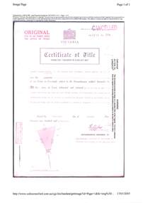
Document, Certificate of Title - George Albert Smith, 1928, 1934
... ...Lot 13...Lot 13 Railway Road, Mitcham and correspondence re outstanding rates....Certificate of Title for Lot 13 Railway Road, Mitcham and correspondence re outstanding rates....Whitehorse Historical Society Inc. 2-10 Deep Creek Road Mitcham melbourne Lot 13 Railway Road, Mitcham and correspondence re outstanding rates. ...Certificate of TitleCertificate of Title for Lot 13 Railway Road, Mitcham and correspondence re outstanding rates.Certificate of Title shire of blackburn and mitcham, land titles, rates, smith, george albert, east road, mitcham, creek road, mitcham, railway road, mitcham, lot 13 -
 Ringwood and District Historical Society
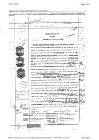
Document, Property Research Notes - Reaghill, Ringwood East, Victoria. Appendix 7 - Certificate of Title Osmond Parsons Wickham Lot 13 Homebush Court Ringwood East - 1957
... Appendix 7 - Certificate of Title Osmond Parsons Wickham Lot 13 Homebush Court Ringwood East - 1957...Osmond Parsons Wickham of 172 Bedford Road Heathmont is now the proprietor of an Estate in Fee-simple subject to the encumbrances notified hereunder in all that piece of land ... 1 acre, 1 rood and 37 and 5/10 perches or thereabouts being Lot 13 on Plan of Subdivision No.41463. Title signed and dated 19th December 1957. ...Appendix 7 - Certificate of Title Osmond Parsons Wickham Lot 13 Homebush Court Ringwood East - 1957 Document ...A4 Landata Victoria printout of Title Vol 8171 Fol 598.Osmond Parsons Wickham of 172 Bedford Road Heathmont is now the proprietor of an Estate in Fee-simple subject to the encumbrances notified hereunder in all that piece of land ... 1 acre, 1 rood and 37 and 5/10 perches or thereabouts being Lot 13 on Plan of Subdivision No.41463. Title signed and dated 19th December 1957. The covenant contained in Instrument of Transfer No. A456395. Vol 3381 Fol 021 Transfer A456395 application references include: Raymond Clive Fisher and Betty Fisher of Labuan Street Sorrento are now proprietors - 23rd January 1962. Caveat No. F364018 1st July 1974 lapsed 14 July 1978 Neville Peter McLean and Betty Mavis McLean of "Glendale" Homebush Court Ringwood East are now proprietors - 30th June 1978. Garry Leonard and Julie Ann Leonard of 9 Peacock Street Burwood are now proprietors - 5th June 1981. -
Ringwood and District Historical Society
Legal record - Conditions of Sale (C.E.Carter), Lot 18 - Bayswater, Lot 5 - Fern Tree Gully, Lot 13 - Bayswater, Lot 1 - Ringwood, Lot 26 - Ringwood, Various Vendors and C.E.Carter, 1941
... Lot 18 - Bayswater, Lot 5 - Fern Tree Gully, Lot 13 - Bayswater, Lot 1 - Ringwood, Lot 26 - Ringwood, Various Vendors and C.E.Carter, 1941....Lot 18 - Bayswater, Lot 5 - Fern Tree Gully, Lot 13 - Bayswater, Lot 1 - Ringwood, Lot 26 - Ringwood, Various Vendors and C.E.Carter, 1941. ...Particulars and Conditions of Sale of Property , from various Vendors to C.E.Carter. -
Ringwood and District Historical Society
Legal record - Conditions of Sale (C.E.Carter), Ringwood - Lot 13, Plan of Subdivision No 7346, C.E.Carter (Agent) to Herbert Williams, 1935
... Ringwood - Lot 13, Plan of Subdivision No 7346, C.E.Carter (Agent) to Herbert Williams, 1935....Ringwood and District Historical Society 125A Warrandyte Road Ringwood North melbourne Particulars and Conditions of Sale of Property , from C.E.Carter (Agent for ES & A Bank) to Herbert Williams Ringwood - Lot 13, Plan of Subdivision No 7346, C.E.Carter (Agent) to Herbert Williams, 1935. ...Particulars and Conditions of Sale of Property , from C.E.Carter (Agent for ES & A Bank) to Herbert Williams -
Ringwood and District Historical Society
Legal record - Conditions of Sale (C.E.Carter), Ringwood , Lot 12, 13, 14 on Plan of Subdivision 7491, Mr & Mrs Hodgson to Mr A.N.Davison, 1946
... Ringwood , Lot 12, 13, 14 on Plan of Subdivision 7491, Mr & Mrs Hodgson to Mr A.N.Davison, 1946....Ringwood and District Historical Society 125A Warrandyte Road Ringwood North melbourne Particulars and Conditions of Sale of Property , from Mr & Mrs Hodgson to Mr A.N.Davison, Register No 7491. Ringwood , Lot 12, 13, 14 on Plan of Subdivision 7491, Mr & Mrs Hodgson to Mr A.N.Davison, 1946. ...Particulars and Conditions of Sale of Property , from Mr & Mrs Hodgson to Mr A.N.Davison, Register No 7491. -
 Eltham District Historical Society Inc
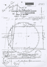
Document - Photocopy, Survey Field Notes of Part of Crown Portion 13, Section 4 at Eltham, Part of Lot 19 Subdivision of 13 Section IV (Holloways), Parish of Nillumbik, County of Evelyn, 5 May 1906
... Survey Field Notes of Part of Crown Portion 13, Section 4 at Eltham, Part of Lot 19 Subdivision of 13 Section IV (Holloways), Parish of Nillumbik, County of Evelyn...Mackensie Tyers, Licensed Surveyor, 5 May 1906 Map Neil Webster Collection Survey Plan Surveyor Field Notes 1906 Application 33777 Application 35953 henry street Main Road Eltham Maria Street Rechabite Hall* A3 printouts, 2 pages Survey Field Notes of Part of Crown Portion 13, Section 4 at Eltham, Part of Lot 19 Subdivision of 13 Section IV (Holloways), Parish of Nillumbik, County of Evelyn Document Photocopy ...Portion of land bounded by: Main Road, Henry Street Application 35953 A. Mackensie Tyers, Licensed Surveyor, 5 May 1906map, neil webster collection, survey plan, surveyor field notes, 1906, application 33777, application 35953, henry street, main road eltham, maria street, rechabite hall* -
Ringwood and District Historical Society
Legal record - Conditions of Sale (C.E.Carter), Blackburn - Crown Allotment 77 , D.Casamento to Miss J.A.E. Stallard -1927
... Particulars and Conditions of Sale of Property , Lots 13 & 14, Peacedale Estate, Nunawading. ...Ringwood and District Historical Society 125A Warrandyte Road Ringwood North melbourne Particulars and Conditions of Sale of Property , Lots 13 & 14, Peacedale Estate, Nunawading. ...Particulars and Conditions of Sale of Property , Lots 13 & 14, Peacedale Estate, Nunawading. From Domenico Casamento to Jessie Stallard. -
 Ringwood and District Historical Society
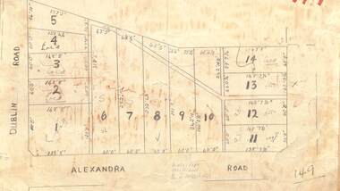
Map - Subdivision Plan, Residential allotments - Dublin Road and Alexandra Road, Ringwood East, Victoria - (Undated)
... Handwritten real estate sales notations include lot 12 and lot 13 £550 each....Ringwood and District Historical Society 125A Warrandyte Road Ringwood North melbourne Handwritten real estate sales notations include lot 12 and lot 13 £550 each. Hand-drawn map on light cardboard backing - 14 numbered allotments with property dimensions. ...Hand-drawn map on light cardboard backing - 14 numbered allotments with property dimensions.Handwritten real estate sales notations include lot 12 and lot 13 £550 each. -
Whitehorse Historical Society Inc.
Legal record - Document, Certificate of Title, 1977
... Certificate of Title vol. 5564 fol. 1112691 for part of Lot 13 Plan of Subdivision no. 4488, cnr. Creek Road and East Road Mitcham, owned by George Albert Smith...Whitehorse Historical Society Inc. 2-10 Deep Creek Road Mitcham melbourne Creek Road Mitcham Smith George Albert East Road Mitcham Certificate of Title vol. 5564 fol. 1112691 for part of Lot 13 Plan of Subdivision no. 4488, cnr. Creek Road and East Road Mitcham, owned by George Albert Smith Certificate of Title vol. 5564 fol. 1112691 for part of Lot 13 Plan of Subdivision no. 4488, cnr. ...Certificate of Title vol. 5564 fol. 1112691 for part of Lot 13 Plan of Subdivision no. 4488, cnr. Creek Road and East Road Mitcham, owned by George Albert SmithCertificate of Title vol. 5564 fol. 1112691 for part of Lot 13 Plan of Subdivision no. 4488, cnr. Creek Road and East Road Mitcham, owned by George Albert SmithCertificate of Title vol. 5564 fol. 1112691 for part of Lot 13 Plan of Subdivision no. 4488, cnr. Creek Road and East Road Mitcham, owned by George Albert Smithcreek road mitcham, smith, george albert, east road mitcham -
 Whitehorse Historical Society Inc.
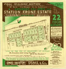
Document, Station Front Estate, 1940
... Brochure advertising auction of 'Station Front estate', Mitcham. 22 lots, 13 April 1940. Auctioneers Edward Haughton Pty Ltd, Drake & Co. ...Whitehorse Historical Society Inc. 2-10 Deep Creek Road Mitcham melbourne station front estate auctions calcutta street mitcham simla street benares street delhi street mitcham road Brochure advertising auction of 'Station Front estate' Brochure advertising auction of 'Station Front estate', Mitcham. 22 lots, 13 April 1940. Auctioneers Edward Haughton Pty Ltd, Drake & Co. ...Brochure advertising auction of 'Station Front estate'Brochure advertising auction of 'Station Front estate', Mitcham. 22 lots, 13 April 1940. Auctioneers Edward Haughton Pty Ltd, Drake & Co. Printed in two colours.Brochure advertising auction of 'Station Front estate'station front estate, auctions, calcutta street, mitcham, simla street, benares street, delhi street, mitcham road -
 Stawell Historical Society Inc
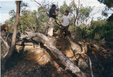
Photograph, Don Rickard, Black Range Quarry Site, May 1999
... On Reverse 2 Black range quarry sites - Granite Cox's Property Lot 13 Bullocky Mary Rd. Don Rickard - May 1999...Stawell Historical Society Inc 46 Longfield St Stawell grampians Black Range Quarry Site Stawell On Reverse 2 Black range quarry sites - Granite Cox's Property Lot 13 Bullocky Mary Rd. Don Rickard - May 1999 Black Range Quarry Site Photograph Don Rickard ...Black Range Quarry SiteOn Reverse 2 Black range quarry sites - Granite Cox's Property Lot 13 Bullocky Mary Rd. Don Rickard - May 1999stawell -
 Stawell Historical Society Inc
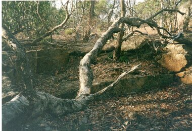
Photograph, Don Rickard, Black Range Quarry Site, May 1999
... On Reverse 3 Black range quarry sites - Granite Cox's Property Lot 13 Bullocky Mary Rd. Don Rickard - May 1999...Stawell Historical Society Inc 46 Longfield St Stawell grampians Black Range Quarry Site Stawell On Reverse 3 Black range quarry sites - Granite Cox's Property Lot 13 Bullocky Mary Rd. Don Rickard - May 1999 Black Range Quarry Site Photograph Don Rickard ...Black Range Quarry SiteOn Reverse 3 Black range quarry sites - Granite Cox's Property Lot 13 Bullocky Mary Rd. Don Rickard - May 1999stawell -
Save the Dandenongs League Inc.
Archive (item), Save the Dandenongs League Incorporated, Shire of Yarra Ranges - Council Meeting - Tuesday, November 9, 1999 - Agenda - B.M. - Keep - Monbulk Trees - Item 1
... Agenda Item No. 1 relates to Monbulk Land - Lots 13 & 14 Main Street, and the Monbolloc Sanctuary Committee....Agenda Item No. 1 relates to Monbulk Land - Lots 13 & 14 Main Street, and the Monbolloc Sanctuary Committee. ... -
Ringwood and District Historical Society
Legal record - Conditions of Sale (C.E.Carter), Blackburn - Crown Allotment 77 , Mr H Jackman to Mr D Casamento. 1926
... Particulars and Conditions of Sale of Property , Lots 11, 12, 13 & 14, Peacedale Estate, Nunawading. ...Ringwood and District Historical Society 125A Warrandyte Road Ringwood North melbourne Particulars and Conditions of Sale of Property , Lots 11, 12, 13 & 14, Peacedale Estate, Nunawading. ...Particulars and Conditions of Sale of Property , Lots 11, 12, 13 & 14, Peacedale Estate, Nunawading. From Harry Jackman to Domenico Casamento. -
 Linton and District Historical Society Inc
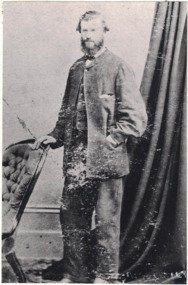
Photograph, John O'Meara on his Wedding Day
... O'Meara is shown as owner of lot 13 in Sussex Street, Linton, which is part of the block now occupied by the Shire Offices. ...O'Meara is shown as owner of lot 13 in Sussex Street, Linton, which is part of the block now occupied by the Shire Offices. ...John O'Meara on his Wedding Day, August 1865. Born 1833, Tipperary, Ireland. Son of Patrick O'Meara and Ann O'Brien. Married Maria O'Brien. Died 11 Nov 1910. J.J. O'Meara. According to the first Lands Dept. plan of the area, a J.J. O'Meara is shown as owner of lot 13 in Sussex Street, Linton, which is part of the block now occupied by the Shire Offices. In an early Post Office Directory (1868), J.J. O'Meara is listed as "Timber Merchant", Sussex Street, Linton.Black and white copy of original portrait showing a man, standing with his right hand resting on the back of a chair. He is wearing a light coloured suit, white shirt and dark bow tie. His left hand is in the pocket of his jacket, which is done up with a single button on the top of the jacket. A wall and curtain in the background. His hair sticks out at the sides and he has a beard and mustache."John O'Meara".john o'meara, j.j. o'meara, weddings -
 Kew Historical Society Inc
Plan - Subdivision Plan, Mayfield Estate, 1927
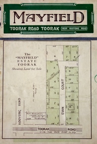
... An existing brick villa (‘Mayfield’) is noted as already constructed on lot 13. The subdivision also notes that the lots adjoin land owned by Sir Edward Miller. ...An existing brick villa (‘Mayfield’) is noted as already constructed on lot 13. The subdivision also notes that the lots adjoin land owned by Sir Edward Miller. ...A number of the plans in the Kew Historical Society’s collection can also be found in other collections, such as those of the State Library of Victoria. A number are however unique to the collection.The Kew Historical Society collection includes almost 100 subdivision plans pertaining to suburbs of the City of Melbourne. Most of these are of Kew, Kew East or Studley Park, although a smaller number are plans of Camberwell, Deepdene, Balwyn and Hawthorn. It is believed that the majority of the plans were gifted to the Society by persons connected with the real estate firm - J. R. Mathers and McMillan, 136 Cotham Road, Kew. The Plans in the collection are rarely in pristine form, being working plans on which the agent would write notes and record lots sold and the prices of these. The subdivision plans are historically significant examples of the growth of urban Melbourne from the beginning of the 20th Century up until the 1980s. A number of the plans are double-sided and often include a photograph on the reverse. A number of the latter are by noted photographers such as J.E. Barnes.The Mayfield Estate subdivision included 14 allotments surrounding Evan Court (now Evans Court) in Toorak. The subdivision adjoined Toorak Road east of Kooyong Road and alerted prospective buyers to how the Toorak Road tram would take them directly to the city. This emphasis on existing transport routes was a feature of subdivisions during a period when car ownership was the preserve of the wealthy. An existing brick villa (‘Mayfield’) is noted as already constructed on lot 13. The subdivision also notes that the lots adjoin land owned by Sir Edward Miller. Today Evans Court extends beyond this subdivision through to Moonga Road.subdivision plans - toorak, mayfield estate, sir edward miller -
 Ringwood and District Historical Society
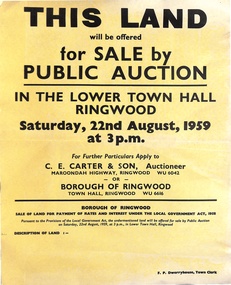
Poster, Land for Sale by Public Auction, Lower Town Hall, Ringwood - Saturday 22nd August, 1959
... Made roads, Water and E.L. 54'x140' approx. Lot 13 Tagell Road Ringwood. 64'x1130' approx. ...Made roads, Water and E.L. 54'x140' approx. Lot 13 Tagell Road Ringwood. 64'x1130' approx. ...Yellow poster and smaller attachment with auction details and summary of four properties offered under Borough of Ringwood instructions for unpaid rates, some with handwritten monetary notations.Lot 49 Patterson Street, East Ringwood (Opp. station). Made Road, Water and E.L. 60'x220' approx. Lot 48 Stoda Street, Heathmont. Water and E.L. 50'x150'. Lot 86 Cnr Heatherbrae & Burwood Avenues, Ringwood. Made roads, Water and E.L. 54'x140' approx. Lot 13 Tagell Road Ringwood. 64'x1130' approx. For further particulars apply to C.E. Carter & Son, Auctioneer, Maroondah Highway, Ringwood (Phone) WU6042, WU6830, or Borough of Ringwood, Town Hall, Ringwood (Phone) WU6616. F.P. Dwerryhouse, Town Clerk. -
 Ringwood and District Historical Society
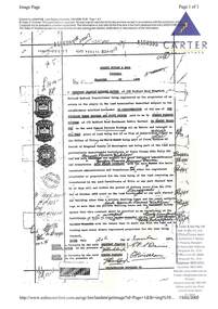
Document, Transfer of Land - Geoffrey Francis Seymour Davies of 139 Bedford Road Ringwood to Osmond Parsons Wickham of 172 Bedford Road Heathmont. 1957
... Transfer of all of estate and interest in Lot 13 on Plan of Subdivison No.41463, being part of Crown Allotment 43, Parish of Ringwood, County of Mornington (and) Certificate of Title Volume 3381 Folio 021. ...Transfer of all of estate and interest in Lot 13 on Plan of Subdivison No.41463, being part of Crown Allotment 43, Parish of Ringwood, County of Mornington (and) Certificate of Title Volume 3381 Folio 021. ...2 A4 size photocopied pagesTransfer of all of estate and interest in Lot 13 on Plan of Subdivison No.41463, being part of Crown Allotment 43, Parish of Ringwood, County of Mornington (and) Certificate of Title Volume 3381 Folio 021. Covenant ... for the time being of land remaining untransferred in the said Certificate of Title ... will not within the period of fifteen years from the 17th day of October 1955 erect on the land transferred or any part thereof any building other than a private dwelling house and the usual outbuildings or more than one private dwelling house. Signed and dated 20th November, 1957. -
 Kew Historical Society Inc
Plan - Subdivision Plan, Violet Farm Estate, 1927
... Like many other subdivisions in Kew and East Kew, older houses (Lots 1 and 13) were often included in the subdivision. ...Like many other subdivisions in Kew and East Kew, older houses (Lots 1 and 13) were often included in the subdivision. ...Pru Sanderson, in her groundbreaking ‘City of Kew Urban Conservation Study : Volume 2 - Development History’ (1988), summarised the periods of urban development and subdivisions of land in Kew. The periods that she identified included 1845-1880, 1880-1893, 1893-1921, 1921-1933, 1933-1943, and Post-War Development. These periods were selected as they represented periods of rapid growth or decline in urban development. An obvious starting point for Sanderson’s groupings involved population growth and the associated economic cycles. These cycles also highlighted urban expansion onto land that was predominantly rural, although in other cases it represented the decline and breakup of large estates. A number of the plans in the Kew Historical Society’s collection can also be found in other collections, such as those of the State Library of Victoria and the Boroondara Library Service. A number are however unique to the collection.The Kew Historical Society collection includes almost 100 subdivision plans pertaining to suburbs of the City of Melbourne. Most of these are of Kew, Kew East or Studley Park, although a smaller number are plans of Camberwell, Deepdene, Balwyn and Hawthorn. It is believed that the majority of the plans were gifted to the Society by persons connected with the real estate firm - J. R. Mathers and McMillan, 136 Cotham Road, Kew. The Plans in the collection are rarely in pristine form, being working plans on which the agent would write notes and record lots sold and the prices of these.The subdivision plans are historically significant examples of the growth of urban Melbourne from the beginning of the 20th Century up until the 1980s. A number of the plans are double-sided and often include a photograph on the reverse. A subdivision plan for nineteen ‘bonny, airy building blocks’ on either side of Violet Grove, Kew East. Violet Grove runs between High Street and Harp Road. Like many other subdivisions in Kew and East Kew, older houses (Lots 1 and 13) were often included in the subdivision. Such houses were in some instances the original properties that were subdivided, or in the case of the Violet Grove subdivision, new houses such as the weatherboard villa on lot 13. This villa is advertised as having a tiled roof, 5 rooms, panelled hall, double doors (Rooms 14 x 12 ft. 6 in. (2) 14 x 12, 12 x 11, 13 x 11). A bricked front verandah, a tiled stove recess and existing sewerage connection added to its saleable potential. Water, electric light and power, and gas were all offered as part of the deal. Violet Grove now has about 35 houses, which indicates that the 19 lots of the subdivision were to be further subdivided by purchasers. [A similar plan is in the Batten & Percy Collection of the State Library of Victoria.]subdivision plans - east kew, violet farm estate, violet grove -- kew (vic.), boorool road -- kew (vic.), harp road -- kew east (vic.) -
![Monnington [Estate], 1935](/media/collectors/550653872162f11fb04854aa/items/5907eb86d0ce0c14e82385c8/item-media/5907ecafd0ce0c14e823e87f/item-fit-380x285.jpg?cb=6) Kew Historical Society Inc
Kew Historical Society IncPlan - Subdivision Plan, Monnington [Estate], 1935, 1935
... In this subdivision plan, Monnington is one of 13 lots for sale. The subdivision created the irregular land holding of Monnington today. ...lots were sold. In a number of cases, the reverse of a subdivision plan in the collection includes a photograph of a house that was also for sale by the agent. These photographs provide significant heritage information relating house design and decoration, fencing and household gardens. Monnington - Adeney Avenue -- Kew (Vic.) Subdivision plans -- Kew (Vic.) The first subdivision of Monnington took place in 1935. At that time, Monnington and 10 new allotments were offered for sale bordering Adeney and Marshall Avenues. In this subdivision plan, Monnington is one of 13 ...Pru Sanderson, in her groundbreaking ‘City of Kew Urban Conservation Study : Volume 2 - Development History’ (1988), summarised the periods of urban development and subdivisions of land in Kew. The periods that she identified included 1845-1880, 1880-1893, 1893-1921, 1921-1933, 1933-1943, and Post-War Development. These periods were selected as they represented periods of rapid growth or decline in urban development. An obvious starting point for Sanderson’s groupings involved population growth and the associated economic cycles. These cycles also highlighted urban expansion onto land that was predominantly rural, although in other cases it represented the decline and breakup of large estates. A number of the plans in the Kew Historical Society’s collection can also be found in other collections, such as those of the State Library of Victoria and the Boroondara Library Service. A number are however unique to the collection.Subdivision plans are historically important documents used as evidence of the growth of suburbs in Australia. They frequently provide information about when the land was sold on which a built structure was subsequently constructed as well as evidence relating to surveyors and real estate and financial agents. The numerous subdivision plans in the Kew Historical Society's collection represent working documents, ranging from the initial sketches made in planning a subdivision to printed plans on which auctioneers or agents listed the prices for which individual lots were sold. In a number of cases, the reverse of a subdivision plan in the collection includes a photograph of a house that was also for sale by the agent. These photographs provide significant heritage information relating house design and decoration, fencing and household gardens.The first subdivision of Monnington took place in 1935. At that time, Monnington and 10 new allotments were offered for sale bordering Adeney and Marshall Avenues. In this subdivision plan, Monnington is one of 13 lots for sale. The subdivision created the irregular land holding of Monnington today. The excision of southwest corner of Monninton was caused by the need to have regular allotments facing the curve in Marshall Avenue.monnington - adeney avenue -- kew (vic.), subdivision plans -- kew (vic.) -
 Ringwood and District Historical Society
Document, Property Research Notes - Reaghill, Ringwood East, Victoria. Appendix 8 - Transfer of Land from G. F. S. Davies to O.P. Wickham and Covenant Details - 1957
... Geoffrey Francis Seymour Davies of 139 Bedford Road Ringwood, retired Medical Practitioner, registered proprietor of an estate in fee simple in the land hereinafter described subject to the encumbrances notified hereunder in consideration of the sum of £1350 paid to me by Osmond Parsons Wickham of 172 Bedford Road Heathmont, Public Servant, do hereby transfer all of my estate and interest in all that piece of land being Lot 13 on Plan of Subdivision No. 41463 in the Office of Titles, being part of Crown Allotment 43, Parish of Ringwood, County of Mornington and being part of the land more particularly described in Certificate of Title Volume 3381 Folio 021 and the said Osmond Parsons Wickham for himself and his heirs executors administrators and transferees doth hereby convenant with the said Geoffrey Francis Seymour Davies, heirs (etc.) ... will not within the period of fifteen years from the 17th October 1955 erect on the land hereby transferred or any part thereof, any building other than a private dwelling house and the usual outbuildings or more than one private dwelling house, and Osmond Parsons Wickham hereby agree that this covenant shall be notified as an encumbrance on the Certificate of Title ... with the intent that it shall run with the land and be binding upon every future registered proprietor for the time being thereof....Geoffrey Francis Seymour Davies of 139 Bedford Road Ringwood, retired Medical Practitioner, registered proprietor of an estate in fee simple in the land hereinafter described subject to the encumbrances notified hereunder in consideration of the sum of £1350 paid to me by Osmond Parsons Wickham of 172 Bedford Road Heathmont, Public Servant, do hereby transfer all of my estate and interest in all that piece of land being Lot 13 on Plan of Subdivision No. 41463 in the Office of Titles, being part of Crown Allotment 43, Parish of Ringwood, County of Mornington and being part of the land more particularly described in Certificate of Title Volume 3381 Folio 021 and the said Osmond Parsons Wickham for himself and his heirs executors administrators and transferees doth hereby convenant with the said Geoffrey Francis Seymour Davies, heirs (etc.) ... will not within the period of fifteen years from the 17th October 1955 erect on the land hereby transferred or any part thereof, any building other than a private dwelling house and the usual outbuildings or more than one private dwelling house, and Osmond Parsons Wickham hereby agree that this covenant shall be notified as an encumbrance on the Certificate of Title ... with the intent that it shall run with the land and be binding upon every future registered proprietor for the time being thereof. ...A4 Landata printout on Carter Real Estate letterhead - Transfer of Land signed and dated 20th November 1957.Geoffrey Francis Seymour Davies of 139 Bedford Road Ringwood, retired Medical Practitioner, registered proprietor of an estate in fee simple in the land hereinafter described subject to the encumbrances notified hereunder in consideration of the sum of £1350 paid to me by Osmond Parsons Wickham of 172 Bedford Road Heathmont, Public Servant, do hereby transfer all of my estate and interest in all that piece of land being Lot 13 on Plan of Subdivision No. 41463 in the Office of Titles, being part of Crown Allotment 43, Parish of Ringwood, County of Mornington and being part of the land more particularly described in Certificate of Title Volume 3381 Folio 021 and the said Osmond Parsons Wickham for himself and his heirs executors administrators and transferees doth hereby convenant with the said Geoffrey Francis Seymour Davies, heirs (etc.) ... will not within the period of fifteen years from the 17th October 1955 erect on the land hereby transferred or any part thereof, any building other than a private dwelling house and the usual outbuildings or more than one private dwelling house, and Osmond Parsons Wickham hereby agree that this covenant shall be notified as an encumbrance on the Certificate of Title ... with the intent that it shall run with the land and be binding upon every future registered proprietor for the time being thereof. -
 Glen Eira Historical Society
Album - Album page, Bureel (Kooyong Road), Circa 1972
... "Burreel" was rated to Burreel Avenue and stood on lot 13 with frontages to Burreel Avenue and Kooyong Road of 198' and 214'. ..."Burreel" was rated to Burreel Avenue and stood on lot 13 with frontages to Burreel Avenue and Kooyong Road of 198' and 214'. ...This photograph is part of the Caulfield Historical Album 1972. This album was created in approximately 1972 as part of a project by the Caulfield Historical Society to assist in identifying buildings worthy of preservation. The album is related to a Survey the Caulfield Historical Society developed in collaboration with the National Trust of Australia (Victoria) and Caulfield City Council to identify historic buildings within the City of Caulfield that warranted the protection of a National Trust Classification. Principal photographer thought to be Trevor Hart, member of Caulfield Historical Society. Most photographs were taken between 1966-1972 with a small number of photographs being older and from unknown sources. All photographs are black and white except where stated, with 386 photographs over 198 pages. From: Glen Eira Heritage Management Plan 1996 by Andrew Ward In 1856, John Allee, a builder from Brighton, purchased C.A. 37 on the south-west corner of Glenhuntly and Kooyong Roads. The land comprised just over 45 acres. By 1863, Francis John Sidney Stephen, a lawyer and cousin of J. Wilberforce Stephen, owned most of lot 37. By 1866, Stephen had a built a "small mansion" named ''Burreel". It was a brick house and Stephen lived there until 1882. By 1884, Mrs Buxton of Hillside Terrace, East Melbourne, had purchased the property. Richard Buxton, a gentleman was listed as occupant and the house described as "brick, eight rooms". NAV was £300. Richard Buxton continued residency in 1887 however in 1888, George Allen, music seller, became occupant. At that time the house had thirteen rooms on twenty-three acres of land. Twelve people lived there and NAV was £920. In 1900, Daniel Luxton, stock and sharebroker and the Honourable John Taverner, M.H.A. leased the property. Fourteen people lived there. Mrs Buxton continued as owner. By 1910, ownership had passed to Mrs Mary Neate, who converted the house to a nursing home. The land had been subdivided by 1913 and sold by ''Buxtons Estate". Burreel Avenue, Baxter, Buxton and Hoddle Streets were created. "Burreel" was rated to Burreel Avenue and stood on lot 13 with frontages to Burreel Avenue and Kooyong Road of 198' and 214'. The house had ten rooms. NAV was £60. Mary Neate, a nurse, continued as owner/ operator of ''Burreel" nursing home in 1927. At that time there were sixteen rooms and fourteen residents. NAV was £100. Mrs Neat remained there until 1947. In 1948, the house was turned into apartments. In the 1980's, the Alexander family purchased it and restored it to a private residence.Burreel 331 Kooyong Road, ELSTERNWICK VIC 3185 - Property No B4950 National Trust https://vhd.heritagecouncil.vic.gov.au/places/65648 This is a large and substantially intact example of the grand villas of nineteenth century Melbourne. The bulk of the house most probably was built in 1866-1868 for Francis John Sidney Stephen, a prominent and highly regarded Melbourne solicitor and a member of an illustrious legal family. Stephen conducted a lucrative private practice and in 1845 was appointed first solicitor to the City of Melbourne; a position he held until his death in 1895. He took an active part in the development of Caulfield and was Shire President in 1874 and 1877. He was a resident at Burreel from 1868 to 1882. The house has evolved in stages, the rear wings possibly remaining from a house built during the 1850s. The existing ornate cast iron verandah was probably built between 1882 and 1888 during the residence of Richard Buckhurst Buxted, a notable boom period auctioneer and real estate agent. George Allan, the founder of Allan's music store, was another important occupier from 1888 to 1991. Bureel's essentially residential quality has been retained and the interior has been well preserved. The significance of this building does not rest in any single unusual outstanding architectural feature, or in its association with a particularly prominent member of society in the past, but rather in the consistent integrity of both the interior and exterior, which results in the survival of an outstanding example of this type of residential building and its associations with two notable citizens. Classified:11/08/1990Page 113 of photograph album with 1 photograph of Burreel in its garden.Handwritten: Bureel [top left] / 113 [bottom left]trevor hart, caulfield, caulfield north, kooyong road, thomas king, mansion, 1860's, bureel, burreel, francis john sidney stephen, city of melbourne, shire president, 1850's, verandah, nursing home, john allee, ornamented corner stones, new orleans manner, plaster rendered, mrs luxton, vincent willis, alexander family, victorian architectural style, ornate cast iron work, lawyers, brick houses, richard buxton, richard buckhurst buxton, george allen, george leavis allan, allans music, daniel luxton, john taverner, mary neate, buxtons estate, land subdivision, mary neat, gardens -
 Kew Historical Society Inc
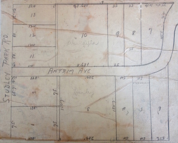
Plan - Subdivision Plan, Windella-Darnley Subdivision, Studley Park, 1920s
... lots in the subdivision. Bisecting the subdivision is a street, Antrim Avenue that was never constructed. A street, which was subsequently constructed in this vicinity, was Merrion Place, which now runs between Studley Park Road and Highfield Grove. There are 13...lots in the subdivision. Bisecting the subdivision is a street, Antrim Avenue that was never constructed. A street, which was subsequently constructed in this vicinity, was Merrion Place, which now runs between Studley Park Road and Highfield Grove. There are 13 ...Subdivision plans are historically important documents used as evidence of the growth of suburbs in Australia. They frequently provide information about when the land was sold on which a built structure was subsequently constructed as well as evidence relating to surveyors and real estate and financial agents. The numerous subdivision plans in the Kew Historical Society's collection represent working documents, ranging from the initial sketches made in planning a subdivision to printed plans on which auctioneers or agents listed the prices for which individual lots were sold. In a number of cases, the reverse of a subdivision plan in the collection includes a photograph of a house that was also for sale by the agent. These photographs provide significant heritage information relating house design and decoration, fencing and household gardens.Version 2 of two subdivision plans (the earlier is 2016.0305.1) for the section of Studley Park Road near the Junction on the south side. Named in the subdivision are the mansions of Darley and Windella (now demolished). Before the subdivision of Darley and Windella, both houses fronted Studley Park Road. Both houses appear to be advertised as lots in the subdivision. Bisecting the subdivision is a street, Antrim Avenue that was never constructed. A street, which was subsequently constructed in this vicinity, was Merrion Place, which now runs between Studley Park Road and Highfield Grove. There are 13 proposed lots in this subdivision in contrast to the earlier plan. This resulted from larger lots being proposed for Studley Park Road.subdivision plans - kew, studley park, windella, darnley, antrim avenue -- kew (vic.), studley park road -- kew (vic.), merrion place -- kew (vic.), merrion grove -- kew (vic.), highbury grove -- kew (vic.) -
 Sunshine and District Historical Society Incorporated
Administrative record - City of Sunshine - Commissioner Mr Alexander Alex George Gillon Collection 1976 - 1982 - Extraordinary business 9th December 1980, City of Sunshine, 9th December 1980
... Albans Planning Permit Application 3 Flats Lots 23 & 25 Madden Street Maidstone Planning Permit Application Extensions to School Classrooms land bounded by Churchill Avenue, Dobson Crescent and Darnley Street Planning Permit Application Restaurant, Service Premises and Associated Signs Red Rooster 204 - 210 Ballarat Road Maidstone Planning Permit Application Enforcement Factory and Petrol Filling Station Lots 13, 14, 15 & 16 North West corner Ballarat Road and Glencairn Avenue Deer Park Planning Permit Application Two Lot Subdivision Ballarat Road Albion Planning Permit Application Junk Yard Scrap Metal Maida Avenue Sunshine North Planning Permit Application Warehouse Lots 30 & 31 Cromer Avenue Sunshine Planning Permit Application Display Home Centre Furlong Road St. ...Albans Planning Permit Application 3 Flats Lots 23 & 25 Madden Street Maidstone Planning Permit Application Extensions to School Classrooms land bounded by Churchill Avenue, Dobson Crescent and Darnley Street Planning Permit Application Restaurant, Service Premises and Associated Signs Red Rooster 204 - 210 Ballarat Road Maidstone Planning Permit Application Enforcement Factory and Petrol Filling Station Lots 13, 14, 15 & 16 North West corner Ballarat Road and Glencairn Avenue Deer Park Planning Permit Application Two Lot Subdivision Ballarat Road Albion Planning Permit Application Junk Yard Scrap Metal Maida Avenue Sunshine North Planning Permit Application Warehouse Lots 30 & 31 Cromer Avenue Sunshine Planning Permit Application Display Home Centre Furlong Road St. ...Catherine Yeung Community Nurse Planning Permit Application 74 Lot Residential Subdivision Opie Road St. Albans Planning Permit Application 3 Flats Lots 23 & 25 Madden Street Maidstone Planning Permit Application Extensions to School Classrooms land bounded by Churchill Avenue, Dobson Crescent and Darnley Street Planning Permit Application Restaurant, Service Premises and Associated Signs Red Rooster 204 - 210 Ballarat Road Maidstone Planning Permit Application Enforcement Factory and Petrol Filling Station Lots 13, 14, 15 & 16 North West corner Ballarat Road and Glencairn Avenue Deer Park Planning Permit Application Two Lot Subdivision Ballarat Road Albion Planning Permit Application Junk Yard Scrap Metal Maida Avenue Sunshine North Planning Permit Application Warehouse Lots 30 & 31 Cromer Avenue Sunshine Planning Permit Application Display Home Centre Furlong Road St. Albans Planning Permit Application Factory Warehouse 4 Arvona Avenue Sunshine North Planning Permit Application Factory Renovation South West corner Somerville Road and Tottenham Parade Planning Permit Application Bus Depot Lot 1 Emu Road Maidstone Planning Permit Application 4 Flats Lot 31 Bardsley Street Sunshine West Planning Permit Application Grain Storage depot Stage 2 Francis Street Brooklyn Planning Permit Application Factory Warehouse North West corner Ballarat Road and Lacy Street Braybrook Planning Permit Application Ground and Forst Floor Offices 239 - 241 Hampshire Road Sunshine Planning Permit Application Factory Lot 30 Frederick Street Brooklyn Planning Permit Application Service Premises Alterations Lot 2 Rosamond Road Maidstone Planning Permit Application 2 Flats 185A Main Road West St. Albans Planning Permit Application Clothing Manufacturer 67 Dumfries Street Deer Park Planning Permit Application Factory Display and Sales Lot 39 Reid Street Ardeer Planning Permit Application Extensions to secondary school Marian College Glengala Road Sunshine West Planning Permit Application Promotion Panel Sign Lots 1, 6 and 7 Berkshire Road Sunshine North Planning Permit Application Shop Bank and Offices 288 Hampshire Road Sunshine Planning Permit Application Brick Store 75 Wright Street Sunshine Planning Permit Application Erection of new Multiple Sclerosis Residential and Day Attendance Centre Furlong Road St. Albans Planning Permit Application Warehouse Alterations 22 St. Albans Road St. Albans Planning Permit Application Junk yard Lot 5 McIntyre Road Sunshine North Planning Permit Application Water Purification Plant Press Filter Platform Smorgon Consolidated Industries Meat and Paper Pty Ltd Planning Permit Application Bread and Cake Stall Level 2 Highpoint West Shopping Centre Rosamond Road Maribyrnong Planning Permit Application Hot Bread Kitchen Glengala Road Sunshine West Planning Permit Application Alterations to Service Station Lot 1 Ballarat Road Braybrook Planning Permit Application Market Extensions Level 1 Highpoint West Shopping Centre Rosamond Road Maribyrnong Planning Permit Application Laboratory and Offices Ballarat Road Sunshine Planning Permit Application Petrol Filling Station and Hotel Neale Road Deer Park Planning Permit Application Residential Subdivision and Industrial Use St. Albans Road and Furlong Road St. Albans Planning Permit Application Take Away Food Shop 100 Station Road Deer Park Planning Permit Application Extension to Sunshine and District Community Hospital King Edward Avenue Albion Planning Permit Application Motor Repair Station and Advertising Signs corner Geelong Road and Francis Street Brooklyn Private Street Construction Ayton Street and Steers Street Sunshine North Closure of Omar Street Maidstone to through traffic Consolidated of Title McDonald Road Colliers Interstate Transport Service Ltd Lot 1 Station Road Albanvale Children's Community Centre Building Over Easement 3 Droitwich Crescent Deer Park Building Over Easement 20 Hook Street St. Albans Building Over Easement 191 Wright Street Sunshine West Building Over Easement 288 Station Road St. Albans Building Over Easement and Location of Building 11 Thwaites Street Sunshine Location of Building Lot 132 Hargreaves Crescent Braybrook Location of Building Lot 1 Station Road Deer Parkcatherine yeung, opie road, st. albans, madden street, maidstone, churchill avenue, dobson crescent, darnley street, st. johns secondary college, ballarat road, glencairn avenue, deer park, albion, maida avenue, sunshine north, cromer avenue, furlong road, arvona avenue, somerville road, tottenham parade, emu road, bardsley street, sunshine west, francis street, brooklyn, lacy street, braybrook, hampshire road, frederick street, rosamond road, main road west, dumfries street, reid street, ardeer, marian college, glengala road, berkshire road, wright street, st. albans road, mcintyre road, highpoint west, maribyrnong, neale road, station road, sunshine and district community hospital, king edward avenue, geelong road, ayton street, steers street, omar street, albanvale children's community centre, droitwich crescent, hook street, thwaites street, hargreaves crescent -
Bendigo Historical Society Inc.
Newspaper - Bendigo Advertiser Collection: Small Town With Big Hearts Article on Tooleen, Aug 04 1993
... This item contains the following documents newspaper articles and black and white photos: 8091.608a Part of Page 19, the Bendigo Advertiser Aug 04 1993 8091.608b Part of Page 19, the Bendigo Advertiser Aug 04 1993 8091.608c Black and White Photo of Campervan approaching Tooleen - Contact BHS for Details 8091.608d Black and White Photo of Terry Tuohey’s and his firewood business, which processes and sells red gum logs to Melbourne - Contact BHS for Details 8091.608e Black and White Photo of the Tooleen Hotel - Contact BHS for Details 8091.608f Black and White Photo of the Tooleen Hotel - Contact BHS for Details 8091.608g Black and White Photo of man on the verandah of the General Store - Contact BHS for Details 8091.608h Black and White Photo of Road Patrol and workers - Contact BHS for Details 8091.608i Black and White Photo of the Tooleen Primary School and Bell out the front - Contact BHS for Details 8091.608j Black and White Photo of paddocks and dam - Contact BHS for Details 8091.608k Black and White Photo of man on the verandah of the General Store - Contact BHS for Details 8091.608l Black and White Photo of truck on the road at Tooleen - Contact BHS for Details 8091.608m Black and White Photo of paddocks and hills at Tooleen - Contact BHS for Details 8091.608n Black and White Photo of road signs and Neighbourhood Watch - Contact BHS for Details 8091.608o Black and White Photo of church - Contact BHS for Details 8091.608p Black and White Photo of Football Ground and Club Rooms - Contact BHS for Details 8091.608q Black and White Photo and newspaper article: Terry Tuohey and his partners harvest fallen red gum timber from local creeks and floodways.The timber is processed and transported to Melbourne, where it is bagged into 13-kilogram lots. Each bag of timber is sold for $5.30 at various outlets. ...This item contains the following documents newspaper articles and black and white photos: 8091.608a Part of Page 19, the Bendigo Advertiser Aug 04 1993 8091.608b Part of Page 19, the Bendigo Advertiser Aug 04 1993 8091.608c Black and White Photo of Campervan approaching Tooleen - Contact BHS for Details 8091.608d Black and White Photo of Terry Tuohey’s and his firewood business, which processes and sells red gum logs to Melbourne - Contact BHS for Details 8091.608e Black and White Photo of the Tooleen Hotel - Contact BHS for Details 8091.608f Black and White Photo of the Tooleen Hotel - Contact BHS for Details 8091.608g Black and White Photo of man on the verandah of the General Store - Contact BHS for Details 8091.608h Black and White Photo of Road Patrol and workers - Contact BHS for Details 8091.608i Black and White Photo of the Tooleen Primary School and Bell out the front - Contact BHS for Details 8091.608j Black and White Photo of paddocks and dam - Contact BHS for Details 8091.608k Black and White Photo of man on the verandah of the General Store - Contact BHS for Details 8091.608l Black and White Photo of truck on the road at Tooleen - Contact BHS for Details 8091.608m Black and White Photo of paddocks and hills at Tooleen - Contact BHS for Details 8091.608n Black and White Photo of road signs and Neighbourhood Watch - Contact BHS for Details 8091.608o Black and White Photo of church - Contact BHS for Details 8091.608p Black and White Photo of Football Ground and Club Rooms - Contact BHS for Details 8091.608q Black and White Photo and newspaper article: Terry Tuohey and his partners harvest fallen red gum timber from local creeks and floodways.The timber is processed and transported to Melbourne, where it is bagged into 13-kilogram lots. Each bag of timber is sold for $5.30 at various outlets. ...Toolleen was once planned for about 100 homes but now has only 10 or 11 houses. The town is described as tranquil but somewhat melancholic due to its reduced population and closed school. The old school, closed for over two years, stands as a symbol of the town's past, with a 1909 bell and a time capsule to be opened in 2034.The schoolyard and classroom remain, though vandalized and unused. Toolleen is situated at a crossroads, making it feel peripheral—at the edge of federal and state electorates, the shire, and even police districts. Residents face inconveniences such as being in the wrong police district, requiring long-distance calls for assistance. Despite decline, Toolleen maintains a sense of contentment, with a pub, general store/post office, and a renowned football ground. The town's farming base and modest expectations contribute to its stability compared to other declining hamlets. Toolleen's layout stems from the 1893 Settlement Act, which aimed to help people become self-sufficient during Victoria's depression.The Plough Inn (the local pub) has been central since the 1860s, rebuilt in 1905, and historically linked to the Spiers family.Recent Revitalization Efforts. The pub, now run by Col and Suzanne Munro, has been restored, attracting both locals and travelers. The Mount Pleasant Football Club remains a key social hub, reinforcing community bonds. The local club is a central hub, hosting regular social gatherings and planning events like a club ball. Sporting activities, especially football, are significant, with local teams performing well and the grand final being a major event. The Mount Pleasant footy ground and associated facilities are notable community assets. The general store and post office, run by Bernard and Donna Linnett, serve as important services for the area’s 75 families. A large, modern turkey farm operated by Teville Tranter is the district’s biggest employer, supplying Melbourne restaurants. Entrepreneurial activity includes Terry Tuohey’s firewood business, which processes and sells red gum logs to Melbourne, demonstrating local value-adding. Residents appreciate the quiet, supportive lifestyle, with newcomers like the Linnetts choosing Toolleen for its community feel. The Tuohey family is prominent in the area, contributing to the town’s close-knit atmosphere and support network.Small Towns With Big Hearts Tooleen. Series of photos and information about Tooleen. Pictures by Peter Hyett. Written by Wayne Gregson. This item contains the following documents newspaper articles and black and white photos: 8091.608a Part of Page 19, the Bendigo Advertiser Aug 04 1993 8091.608b Part of Page 19, the Bendigo Advertiser Aug 04 1993 8091.608c Black and White Photo of Campervan approaching Tooleen - Contact BHS for Details 8091.608d Black and White Photo of Terry Tuohey’s and his firewood business, which processes and sells red gum logs to Melbourne - Contact BHS for Details 8091.608e Black and White Photo of the Tooleen Hotel - Contact BHS for Details 8091.608f Black and White Photo of the Tooleen Hotel - Contact BHS for Details 8091.608g Black and White Photo of man on the verandah of the General Store - Contact BHS for Details 8091.608h Black and White Photo of Road Patrol and workers - Contact BHS for Details 8091.608i Black and White Photo of the Tooleen Primary School and Bell out the front - Contact BHS for Details 8091.608j Black and White Photo of paddocks and dam - Contact BHS for Details 8091.608k Black and White Photo of man on the verandah of the General Store - Contact BHS for Details 8091.608l Black and White Photo of truck on the road at Tooleen - Contact BHS for Details 8091.608m Black and White Photo of paddocks and hills at Tooleen - Contact BHS for Details 8091.608n Black and White Photo of road signs and Neighbourhood Watch - Contact BHS for Details 8091.608o Black and White Photo of church - Contact BHS for Details 8091.608p Black and White Photo of Football Ground and Club Rooms - Contact BHS for Details 8091.608q Black and White Photo and newspaper article: Terry Tuohey and his partners harvest fallen red gum timber from local creeks and floodways.The timber is processed and transported to Melbourne, where it is bagged into 13-kilogram lots. Each bag of timber is sold for $5.30 at various outlets. A tonne of Toolleen wood retails for $407.70, reflecting the value-added approach. The Tuohey family has deep roots in Toolleen, contributing to the local economy and community identity. 8091.608r Black and White Photo of the bar of the pub with possibly Suzanne Munro behind - Contact BHS for Details 8091.608s Black and White Photo of a dog in the middle of the road with traffic approaching - Contact BHS for Details 8091.608t Black and White Photo of a dog in the middle of the road with traffic approaching - Contact BHS for Details 8091.608u Black and White Photo of Terry Tuohey’s and his firewood business, which processes and sells red gum logs to Melbourne - Contact BHS for Details 8091.608u Black and White Photo of van and paddocks along the road - Contact BHS for Details 8091.608v Black and White Photo of Football Ground and Club Rooms - Contact BHS for Detailsnewspaper, bendigo advertiser, tooleen -
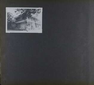
 Ringwood and District Historical Society
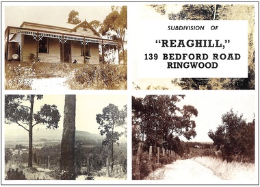
Archive, Richard Carter Collection - REAGHILL Subdivision Research (Parent Record)
... Prices were typically from £1350, the price paid for Lot 13 in 1957. The Role of Frank Leslie Walker These notes have so far recorded that of the sixty acres originally owned by Wallace Bruce in 1900, some 34.875 acres were sold to Dora Davies in 1909 and subdivided and sold by her descendants. ...Prices were typically from £1350, the price paid for Lot 13 in 1957. The Role of Frank Leslie Walker These notes have so far recorded that of the sixty acres originally owned by Wallace Bruce in 1900, some 34.875 acres were sold to Dora Davies in 1909 and subdivided and sold by her descendants. ...This record is the Parent Record for researching the subdivision of Reaghill, 139 Bedford Road, Ringwood, compiled by Richard Carter. "Reaghill" is part of an older larger holding of sixty acres which came to comprise Vista Avenue, Vista Court, Homebush Court, Rawson Court and Wombalano ParkTranscript: Researching “Reaghill" The property “Reaghill” originally stood at 139 Bedford Road, Ringwood East before the property was subdivided in the 1950s and took a new address and frontage to Vista Avenue, Ringwood East. The purpose of these notes is to trace the origins of the property from the year 1900 to the present day. Information in the notes is sourced from the archives of Carter Real Estate, from Land Titles Office records and from the book of the history of Ringwood, “Ringwood, Place of Many Eagles” by Hugh Anderson. “Reaghill” is part of an older larger holding of sixty acres. It Is the story of those 60 acres, which now comprise Vista Avenue, Vista Court, Homebush Court, Rawson Court and Wombalano Park, which Is the subject of these notes. Earlier Times A convenient starting point for these notes Is the year 1900. On 11th June 1900 Wallace Bruce of 68 High Street, Windsor became registered as the proprietor of “sixty acres or thereabouts” (24.28 hectares) being part of Crown Allotment 43 Parish of Ringwood County of Mornington. That title. Volume 2773 Folio 485 did not name the streets to which the property abutted but clearly they were Canterbury Road at its intersection with Bedford Road. Title records a lease of the property from Wallace Bruce to Thomas Oates, with the lease endorsed on title on 22 July 1903 and removed 16 June 1908. Wallace Bruce subsequently subdivided the land Into three parcels, two of which he sold to Dora Stanisforth Davies during 1909 and the balance he sold to Frank Leslie Walker in 1914. The Era of the Davies Wallace Bruce firstly sold the western portion of the property, containing twenty four acres three roods and 20 perches (24.875 acres or 10.0667 hectares) on 6 October 1909. The new title, Volume 3381 Folio 021, records the new proprietor as “Dora Stanisforth Davies, wife of Seymour George Pilkington Davies of Burwood Road, Hawthorn, Bank Manager”. Shortly thereafter, Wallace Bruce sold a further parcel of “ten acres or thereabouts” (4 hectares) being the north eastern portion of his original holding. That title, Volume 3384 Folio 795, showed the purchaser once again as “Dora Stanisforth Davies, wife of Seymour George Pilkington Davies of Burwood Road Hawthorn, Bank Manager”. It is noteable that the second, title which is dated 8 December 1909, had no abuttal to any road, nor was it at any time (even when subdivided in the 1950s) consolidated with Davies' adjoining title. Both titles then recorded that Dora Stanisforth Davies died on 19 February 1945 with probate of her will being granted to John Seymour Davies of 69 Grantham Street West Brunswick, Medical Practitioner, and Hugh Percival Hall of 339 Collins Street Melbourne, Solicitor. Almost two years later, on 6th December 1946, both parcels of land were transferred by the Executors to Geoffrey Francis Seymour Davies of 20 Albert Road Strathfield N.S.W, Medical Practitioner. From this chronology it could be surmised that one of Dora Davies’ executors, John Seymour Davies, was probably her son. Was Geoffrey Francis Seymour Davies another son, or was he her grandson? In any event Geoffrey Francis Seymour Davies set about subdividing what was then the property “Reaghill” and its 34.875 acres (14.11 hectares). The Subdivision of “Reaghill The subdivision of “Reaghill” was made more viable by the subdivision in 1931 of the property to the north and the creation of Scenic Avenue, Vista Avenue and Grandview Avenue, all of which abutted “Reaghill’s” northern boundary. In fact Geoffrey Francis Seymour Davies bought the freehold to Grandview Avenue, Scenic Avenue and Vista Avenue in July 1955 for £84-9-0 to give him legal rights over those roads. Title to those roads and the newly created Vista Avenue, Vista Court and Homebush Court remain in his name to this day. It is particularly interesting to note that whilst those streets had typical allotments of about 1000 square metres, the subdivision of Reaghill was into blocks of one to two acres or more (4000 square metres to about one hectare) except for the blocks fronting Bedford Road. That speaks volumes about Davies’ attitude to the land, its natural beauty, its topography and vegetation. “Reaghill” was subdivided into twenty two lots by Plan of Subdivision LP 41463. The first eleven lots came off Vista Avenue and formed an extension of Vista Avenue and a newly created Vista Court. Lot sizes ranged from 1 acre 1 rood 1½ perches (5097 square metres) to 2 acres 3 roods 21½ perches (1.167 hectares). A further four lots came off Homebush Court, a newly created court off Bedford Road. Those lots ranged from 1 acre 1 rood 29 perches (5792 square metres) to 2 acres 1 rood 39 ®/io perches (1.01 hectares). Seven further lots, parallelogram in configuration, fronted Bedford Road and had a typical area of 1518 square metres. The names of the streets (“Vista” Avenue/Court and “Homebush” Court) give an insight into the elevation of the land, the views it offered and the bushland it featured. The Covenant As evidence of Davies’ desire to maintain the bush setting of the property, covenants were imposed on the transfers of Lots 1 to 15 (the acreage lots). That covenant allowed for only one dwelling house to be erected on each of those lots for a period of 15 years from sale. Effectively it froze subdivision for 15 years. But 15 years came around quickly. The Sales “Reaghill” 139 Bedford Road, Ringwood was offered for Private Sale as “22 Excellent Residential Allotments” by estate agents Anderson & Hickling of 239 Collins Street Melbourne (telephone Central 25!), with a “protective covenant” of one dwelling house only on lots 1-15 for a period of 15 years. Solicitors for the vendor were Messrs Meares, Duigan & Hall of 139 Collins Street Melbourne. Sales commenced in 1955 and went through to 1967. Prices were typically from £1350, the price paid for Lot 13 in 1957. The Role of Frank Leslie Walker These notes have so far recorded that of the sixty acres originally owned by Wallace Bruce in 1900, some 34.875 acres were sold to Dora Davies in 1909 and subdivided and sold by her descendants. The balance of Wallace Bruce’s land was sold on 6th April 1914 to Frank Leslie Walker. This is the land at the south east corner of Bruce’s holding fronting Canterbury Road and which now comprises Rawson Court and Wombalano Park. Frank Leslie Walker “of Albany Chambers, Collins Street Melbourne” was described as an Art Decorator. In “Ringwood - Place of Many Eagles” he is shown as living on his land “in a house which was surrounded by a four foot high brick wall and the long drive of rough cream-coloured Lilydale gravel was entered through handsome wrought iron gates obtained from some building wrecker”. The “old rambling house" had been extended and renovated using secondhand doors, windows and timber. “Every inch of wall space seemed to be crammed from floor to ceiling with oils, watercolours, etchings and drawings of all sorts by well known artists”. On 13th August 1954 Frank Leslie Walker transferred an area of 12 acres 3 rood 21 perches (5.213 hectares) to The Mayor Councillors and Burgesses of the Borough of Ringwood for no consideration as a Gift “for the providing of pleasure grounds on places of public resort or public recreation”. That is now Wombalano Park. The balance of his property, containing 6 acres 1 rood 5 perches (2.54 hectares) and including the original homestead (named Wombalano?) was gifted by Frank Leslie Walker to his nephew on 25 November 1955. It was later subdivided as Rawson Court in 1956. The house no longer survives. The “Reaghill” Homestead The original homestead on Wallace Bruce’s holding, as has just been described fronted Canterbury Road in the area which is now Rawson Court. The age of the house is unknown but is described in 1914 as being “old and rambling”. The “Reaghill” homestead is likely to have been built by the Davies and was retained on Lot 11 of their subdivision. Its date of construction is not known but might have been soon after the Davies bought the land in 1909. Lot 11, with “Reaghill” was not sold in the 1950s as part of the land subdivision and sale. It remained as the family home of Dr. Davies until its sale in 1968 (without the 15 year covenant) to James Hamilton Kelly of New York, USA for $15,000. In time, Lot 11 was resubdivided. The house today remains on a reduced site of 7112 square metres, still on the highest point in the locality with fine views. Further Subdivisions Once the 15 year time frame of the covenant expired, the various owners of the lots, having built homes, proceeded to subdivide their surplus land. Lot 1 was first, followed by Lot 7. Only four of the original 15 acreage lots have not been subdivided. Some subdivisions were less respectful of their environment and neighbourhood than others. Maroondah City Council's planning scheme provides for a minimum lot size of 864 square metres in the locality. But the horse has already bolted. Summary “Reaghill” in its heyday, and the acreage properties which later surrounded it, contributed some of the finest and most exclusive properties in Ringwood East. Notably, the locality was home to a significant number of local medicos over the years. Its location dose to the newly relocated Tintern CEGGS gave it added exclusivity. Subdivision over the years has impinged on the beauty and the environment. However it is still a most important part of Ringwood East, with a rich history. R.A Carter January 2005 -
 Bendigo Military Museum
Postcard - POSTCARD, FARNHAM, U.K, Valentine's Series, cWW1
... 13. Castle Street, Farnham. Handwritten in black ink on back. 'I think you will know where this is as I have told you quite a lot about Farnham, it is where Florrie is. ...13. Castle Street, Farnham. Handwritten in black ink on back. 'I think you will know where this is as I have told you quite a lot about Farnham, it is where Florrie is. ...1. Florrie is a relative living in Farnham. 2. R.H. Baron married Elsie Keast in 1921. All cards relate to R.H. Baron's visits to Farnham whilst on leave to see Florrie. Part of the 'Robert H. Baron', no.3596 and Cooper Collection. See Catalogue No. 1981P for details of Baron's service.1. Coloured scene of a ruined castle and surrounding gardens. 2. Coloured scene of a garden with building and ruins in background. 3. Coloured photograph of a red brick building with battlement. 4. Coloured street scene with buildings, horse drawn transport and pedestrians. 5. Coloured photograph of the nave of a church looking towards the alter. 6. Coloured street scene with buildings and horse drawn transport. 7. Coloured view across a street to a white walled building with horse drawn transport. 8. Coloured photograph of a church, graveyard in foreground. 9. Black and white photograph of a castle surrounded by trees. 10. Black and white photograph of a forest scene with people standing on a bridge. 11. Black and white photograph of a street scene with buildings, horse drawn transport and people. 12. Black and white photograph of the tower of a church. Graveyard in the foreground. 13. Black and white photograph of a street scene with buildings, horse drawn transport and pedestrians. Castle on the hill in background. 14. Black and white photograph of a street scene with buildings, motor cars and pedestrians. 15. Black and white photograph of a street scene with buildings, motor cars, horse drawn transport and pedestrians. 16. Black and white photograph of a wooded valley. Houses on a hill in the background. 17. Black and white photograph of an avenue of trees. 18. Black and white photograph taken in a park. Three people standing on a bridge over a stream.1. The Keep, Farnham Castle. Handwritten in black ink on back: 'This is one of the pretty places around Farnham. I was all once here with Florrie. Bob' 2. In Castle grounds, Farnham. Handwritten in black ink on back: 'Dear Elsie, these are some places that visit... when I was down at Flories place. Bob xxxxxx' 3. Farnham Castle. 4. West Street, Farnham. 5. Parish Church, Farnham. 6. Castle Street, Farnham. 7. The Church House, Farnham. 8. Parish Church, Farnham. 9. Farnham Castle. 10. Red Hill Hanger, Farnham. Handwritten in black ink on back: 'Letter to R.H. Baron's sister - no date.' 11. South Street, Farnham. Handwritten in black ink on back: 'this part of the place I spent my leave at this is where Florrie is.' 12. Farnham Parish Church. Handwritten in black ink on back: 'Letter to R.H. Baron's mother - dated 24 July 1918.' 13. Castle Street, Farnham. Handwritten in black ink on back. 'I think you will know where this is as I have told you quite a lot about Farnham, it is where Florrie is. I spent my leave here. This is Castle Street and the castle is right on the top of the hill.' 14. Borough, Farnham. Handwritten in black ink on back. ' This is the place where Florrie lives. I spent my last leave their (sic), Bob.' 15. West Street, Farnham. Handwritten in pencil on back. 'Pte R.H. Baron, 57 Battalion, Australian Imperial Forces Abroad.' 16. Lower Bourne Valley, Farnham. Handwritten in black ink on back: 'Partial letter from R.H. Baron to his sweetheart.' 17. The Avenue, Farnham. Handwritten in black ink on back: 'Partial letter from R.H. Baron to his mother.' 18. Recreation Ground, Farnham. Handwritten in black ink on back: 'Letter to Doris from R.H. Baron - no date.' robert h. baron, cooper collection, postcards, farnham uk -
 Eltham District Historical Society Inc
Photograph - Aerial Photograph, Landata, Eltham; Crown Allotment 15, Section 5, Parish of Nillumbik (Stokes Orchard Estate), Dec. 1945
... 13, 1925, to local farmer, Robert David Taylor, a former Shire of Eltham Councillor (1911-1920) and Shire President (1919). Taylor had extensive land holdings stretching west towards Bible Street and Main Road. The Taylor home was situated at the top of the hill in Bible Street at present day 82 Bible Street. At the time of Taylor’s purchase in 1925, CA15 was subdivided into 48 lots...13, 1925, to local farmer, Robert David Taylor, a former Shire of Eltham Councillor (1911-1920) and Shire President (1919). Taylor had extensive land holdings stretching west towards Bible Street and Main Road. The Taylor home was situated at the top of the hill in Bible Street at present day 82 Bible Street. At the time of Taylor’s purchase in 1925, CA15 was subdivided into 48 lots ...Centred on present day Diosma Rd, Stokes Pl, Nyora Rd and Eucalyptus Rd Historic Aerial Imagery Source: Landata.vic.gov.au Aerial Photo Details: Project No :5 Project : MELBOURNE AND METROPOLITAN AREA PROJECT Run : 36 Frame : 60546 Date : 12/1945 Film Type : B/W Camera : EAG4 Flying Height : 10200 Scale : 6000 Film Number : 195 GDA2020 : 37°42'47"S, 145°09'56"E MGA2020 : 338306, 5824438 (55) Melways : 22 C4 (ed. 42) A History of the Development of Crown Allotment 15, Section 5, Parish of Nillumbik – Stokes Orchard Crown Allotment 15, Section 5, Parish of Nillumbik (CA15) is a square allotment of 158 acres or approximately a quarter of a square mile. It lies just beyond the eastern end of Pitt Street, south of Nyora Road to the northern end of Eucalyptus Road and extends east from Eucalyptus Road to Reynolds Road. The topography of CA15 is generally steep, sloping up to a hill near the centre of the land, the ridgeline passing through the properties along the southern side of Diosma Road. Eucalyptus Road is a straight north-south road with its northern end at the north west corner of CA15. Until the end of the 1970s this road was an un-named Government Road and was largely not open to traffic. With residential development in the 1970s the road was constructed, and the council allocated the name obviously in recognition of the predominant species of the local bushland. CA15 was purchased from the Crown by George D’Arley Boursiquot, a prominent Melbourne printer, on 28th October 1852. On November 23, 1922, former Member for Gippsland and Melbourne Real Estate Agent, Hubert Patrick Keogh purchased the allotment then sold it March 13, 1925, to local farmer, Robert David Taylor, a former Shire of Eltham Councillor (1911-1920) and Shire President (1919). Taylor had extensive land holdings stretching west towards Bible Street and Main Road. The Taylor home was situated at the top of the hill in Bible Street at present day 82 Bible Street. At the time of Taylor’s purchase in 1925, CA15 was subdivided into 48 lots that could be described as small rural properties or large residential lots. A typical lot size was one hectare or 2.5 acres. The subdivision created two roads, Nyora Road, and Diosma Road, each following an irregular alignment between Eucalyptus and Reynolds Roads. However, the lots were not sold off separately nor were the roads constructed. The land effectively remained as one parcel for many further years. Robert David Taylor died November 30, 1934, and probate was granted to his son of the same name, Robert David Taylor of Bible Street, Salesman and William McLelland Vance Taylor of 73 Emmeline Street, Northcote, Clerk, with the transfer of the land into their names on July 8, 1935. Frank Stokes worked as a qualified accountant at Kennons leather factory in Burnley, while living at 1 Thomas Street, Mitcham. He suffered from migraines and wanted to return to working the land (he had previously worked on farms and orchards since coming to Australia from England in 1926, both in WA and Vic.). He first travelled to the district by train in July 1942 to find land with the intention to establish an orchard. By chance he met Arthur Bird of Bird Orchard (bounded by Pitt Street, Eucalyptus Road, and Wattle Grove) and they got talking over their common interest. Arthur put Frank up for the night and pointed out the land, 158 acres- part of the Taylor Estate- £900, Crown Allotment 15, Section 5, Parish of Nillumbik (CA15) somewhat diagonally opposite Bird Orchard. Stokes applied through the Riverina Agency to purchase the land who in turn applied for permission from Canberra to sell as there was a new government regulation introduced during the Second World War banning land sales except for immediate production. Stokes obtained a loan on his Mitcham house of £600 @ 5% and paid £450 deposit with quarterly payments of £15 spread over 5 years. Stokes was assisted and advised by Arthur Bird who farmed the neighbouring orchard. In early 1943 Stokes took possession and would catch the train out to Eltham on Fridays after work and began building a hut on the corner of Nyora Road and the Government Road (Eucalyptus Road) for shelter and to lock up tools. He established an orchard on the central western part of the land through the centre of which ran a natural waterway (part of the present-day linear park) and was able to pay a neighbour (Hawkins) to help with clearing and fencing 25 acres, and with a horse and single furrowed plough, planted approximately 2,500 fruit trees - cherries, peaches, plums, almonds, pears, apricots and lemons as well as a few apples and oranges; a massive task. Aerial photographs from the 1940s through to the 1990s clearly show the orchard with most of the larger CA15 site remaining as natural bushland. A huge problem was hares and rabbits eating all the new buds off the tiny trees. As well as laying poison he painted the trees with a mixture of cow manure and lime, often working by moonlight. Procurement of wire and wire netting was difficult because of the war but after much effort he obtained a permit from the Agricultural Department for supplies in March 1944. In February 1945 Stokes applied for a permit to build a “packing shed” as no house building was allowed. It was to be 33 feet x 21 feet and cost £312. It was constructed mostly from second-hand materials, which were hard to obtain, especially iron for roofing. Stokes finished work at Kennons on October 31, 1945, and in March 1946 he sold the family home at Mitcham for £1,230 plus £170 for furniture. On May 15, 1946, title to the CA15 property was issued to Frank Howard Alfred Stokes, Orchardist and Gladys Ethel Stokes, Married Woman, both of Pitt Street, Eltham. The family of five then moved into the very unfinished “packing shed” at Eltham, which was a struggle to weatherproof. Eventually rooms were divided off and lined with hessian bags and whitewashed. Their income was firewood (cut and sold), selling rockery stones and cut Sweet Bursaria. (It was discovered during the 1940s that Sweet Bursaria contained the sunscreen compound Aesculin. The RAAF utilised this compound from Sweet Bursaria during WW2 for pilots and gunners.) The orchard’s first fruit sale was a half-case of Le Vanq peaches in December 1947 for the price of 8 shillings. In 1956 plans for house were drawn and Glen Iris bricks purchased (1956 Olympic Rings variant). The building of the house commenced in 1957 - 12 feet of original packing shed was removed – and was completed in 1959. Water was connected from newly built pressure storage on the property at the end of 1959 and the electricity connection for the first time at 3pm on April 29, 1960. The house remains to present day (somewhat modified) at 1 Nyora Road, home to Nyora Studio Gallery. On occasions, spare remnants of the 1956 bricks have been known to be unearthed in gardens on the estate as they were utilised by Frank Stokes to fill in rabbit holes. On May 26, 1950, a parcel of land was compulsorily acquired by the Melbourne and Metropolitan Board of Works on the hilltop to establish an easement for a high-level service reservoir to augment Eltham’s water supply. The project also included pipe tracks for the necessary water mains. The reservoir has now been superseded by higher level water tanks east of Reynolds Road and its former site is now a public reserve. On November 27, 1964, the State Electricity Commission served notice to compulsorily acquire a further parcel through the eastern part of the land for a major electricity transmission line that augmented supply from the La Trobe Valley to Melbourne. The easement was registered February 11, 1966. The easement was widened July 18, 1969 for a second transmission line to be constructed. In 1971 Melbourne Metropolitan Planning Scheme amendments adopted Nyora Road as the boundary between a residential zone to the north and a rural zone to the south. This determined the future development of the land. In the mid-1970s the Shire of Eltham divided the orchard into numerous rate-able parcel lots, the 48 lots having been established in 1925 and the subsequent rates assessment proved unsustainable for Stokes. He commenced selling lots outside the boundary of the orchard, north of Diosma and South of Nyora. However shortly later the land between Nyora and Diosma Roads and west of the electricity easement was sold and subdivided into residential lots, a housing development by Macquarie Builders and marketed as the Stokes Orchard Estate. New streets were created, and most were named after trees, although one, Stokes Place, commemorates the former owners. The development was undertaken in two stages; Stage 1 (1975) encompassing Scarlet Ash Court, Ironbark Close and Peppermint Grove bounded by Nyora and Eucalyptus roads and Stage 2 (1978) encompassing Stokes Place, Orchard Way, The Crest and The Lookout bound by Nyora and Diosma roads. The developer, Macquarie Builders went bankrupt shortly after the release of Stage 2 leaving many purchasers to fend for themselves and arrange for their own independent builders. There were also difficulties with sewerage for the land immediately south of Diosma Road and so the conventional residential lots were abandoned in favour of larger lots. The development of Orchard Way, The Crest and The Lookout did not proceed as planned and the proposed lots were incorporated into five-acre parcels instead. These included a low-density group housing development by the Graves family and the award winning Choong House (1983) with Gordon Ford developed garden immediately next door situated on the ridge of the hill nestled amongst the original bush, Eucalypt trees and Sweet Bursaria. In 1994, Nillumbik Shire Council applied Significant Environment and Significant Landscape overlays upon the properties on the south side of Diosma Road to ensure protection of this natural bush garden environment. With the arrival of the sewer along Diosma Road in the 1990s, most of these five-acre parcels have since been subdivided multiple times. The Choong house presently sits on a 2.7-acre property, which in 2022 Nillumbik Council nominated for Cultural Significance Heritage protection and is considered potentially significant at State level. The Stokes family were also associated with the Eltham Christian Church. In the 1970s this church had met in temporary premises in Eltham. Lots of the original 1925 subdivision remained south of Nyora Road and a number of these lots were utilized for the Eltham Christian School, which was established by the Eltham Christian Church in 1981. The school operated on this site until 2000. The premises are now used by The Vine Baptist Church. By the mid-1980s the whole of CA15 had been developed for residential and school purposes, except for the sections north of Diosma Road and between the transmission lines and Reynolds Road. Sewerage issues had been resolved for the section north of Diosma Road and in 1987 it was in the process of being subdivided into residential lots. The development coincided with the discovery of colonies of the rare and endangered Eltham Copper Butterfly on the site. This resulted in a community and political campaign to save the butterfly habitat. With the co-operation of the land developer the subdivision was altered to create two bushland reserves in the critical butterfly habitat areas. In the late 1980s the State Government was investigating options for establishing a metropolitan ring road link between Diamond Creek and Ringwood. The chosen route was adjacent to Reynolds Road and so this created a freeze on development of CA15 between Reynolds Road and the electricity easement. The ring road proposal was eventually abandoned, and this part of the land was subdivided into low density residential lots. Diosma Road has been discontinued at the electricity easement and the eastern part incorporated into View Mount Court with access from Reynolds Road. The whole of CA15 has now been developed for residential or associated purposes, ranging from conventional density to quite low density south of Nyora Road. Some remnants of the orchard remain, a few cherry trees on the Graves property and a lone apple tree in Stokes Place. The butterfly reserves comprise significant areas of remnant bushland. Linear reserves through the estate link with central Eltham via the Woodridge linear reserve and with Research along the electricity easement. CA15 as it exists today has a complicated history of rural use, Government acquisition, urban development, and community action. References: • “Stokes Orchard, an incomplete history”; Russell Yeoman with Doug Orford • Correspondence, Beryl Bradbury (nee Stokes) • Aerial Photographs, 1931-1991, Landata (landata.vic.gov.au) • Certificate of Title, Vol. 4930 Fol. 985900 • Plan Number LP 10859 aerial photo, diosma road, eltham copper butterfly, eucalyptus road, ironbark close, nyora road, peppermint grove, peter & elizabeth pidgeon collection, power transmission lines, reynolds road, scarlet ash court, stokes orchard estate, stokes place, woodridge estate, frank stokes -
 Eltham District Historical Society Inc
Photograph - Aerial Photograph, Landata, Eltham; Crown Allotment 15, Section 5, Parish of Nillumbik (Stokes Orchard Estate), Nov. 1931
... 13, 1925, to local farmer, Robert David Taylor, a former Shire of Eltham Councillor (1911-1920) and Shire President (1919). Taylor had extensive land holdings stretching west towards Bible Street and Main Road. The Taylor home was situated at the top of the hill in Bible Street at present day 82 Bible Street. At the time of Taylor’s purchase in 1925, CA15 was subdivided into 48 lots...13, 1925, to local farmer, Robert David Taylor, a former Shire of Eltham Councillor (1911-1920) and Shire President (1919). Taylor had extensive land holdings stretching west towards Bible Street and Main Road. The Taylor home was situated at the top of the hill in Bible Street at present day 82 Bible Street. At the time of Taylor’s purchase in 1925, CA15 was subdivided into 48 lots ...Centred over present day Reynolds Road and Mount Pleasant Road, Eltham (including Diosma Rd, Stokes Pl, Nyora Rd and Eucalyptus Rd) Historic Aerial Imagery Source: Landata.vic.gov.au Aerial Photo Details: Project No :1931 Project : MALDON PRISON Run : 21 Frame : 3160 Date : 11/1931 Film Type : B/W Camera : F8 Flying Height : 11000 Scale : 18860 Film Number : 60 GDA2020 : 37°43'31"S, 145°10'20"E MGA2020 : 338912, 5823086 (55) Melways : 22 E8 (ed. 42) A History of the Development of Crown Allotment 15, Section 5, Parish of Nillumbik – Stokes Orchard Crown Allotment 15, Section 5, Parish of Nillumbik (CA15) is a square allotment of 158 acres or approximately a quarter of a square mile. It lies just beyond the eastern end of Pitt Street, south of Nyora Road to the northern end of Eucalyptus Road and extends east from Eucalyptus Road to Reynolds Road. The topography of CA15 is generally steep, sloping up to a hill near the centre of the land, the ridgeline passing through the properties along the southern side of Diosma Road. Eucalyptus Road is a straight north-south road with its northern end at the north west corner of CA15. Until the end of the 1970s this road was an un-named Government Road and was largely not open to traffic. With residential development in the 1970s the road was constructed, and the council allocated the name obviously in recognition of the predominant species of the local bushland. CA15 was purchased from the Crown by George D’Arley Boursiquot, a prominent Melbourne printer, on 28th October 1852. On November 23, 1922, former Member for Gippsland and Melbourne Real Estate Agent, Hubert Patrick Keogh purchased the allotment then sold it March 13, 1925, to local farmer, Robert David Taylor, a former Shire of Eltham Councillor (1911-1920) and Shire President (1919). Taylor had extensive land holdings stretching west towards Bible Street and Main Road. The Taylor home was situated at the top of the hill in Bible Street at present day 82 Bible Street. At the time of Taylor’s purchase in 1925, CA15 was subdivided into 48 lots that could be described as small rural properties or large residential lots. A typical lot size was one hectare or 2.5 acres. The subdivision created two roads, Nyora Road, and Diosma Road, each following an irregular alignment between Eucalyptus and Reynolds Roads. However, the lots were not sold off separately nor were the roads constructed. The land effectively remained as one parcel for many further years. Robert David Taylor died November 30, 1934, and probate was granted to his son of the same name, Robert David Taylor of Bible Street, Salesman and William McLelland Vance Taylor of 73 Emmeline Street, Northcote, Clerk, with the transfer of the land into their names on July 8, 1935. Frank Stokes worked as a qualified accountant at Kennons leather factory in Burnley, while living at 1 Thomas Street, Mitcham. He suffered from migraines and wanted to return to working the land (he had previously worked on farms and orchards since coming to Australia from England in 1926, both in WA and Vic.). He first travelled to the district by train in July 1942 to find land with the intention to establish an orchard. By chance he met Arthur Bird of Bird Orchard (bounded by Pitt Street, Eucalyptus Road, and Wattle Grove) and they got talking over their common interest. Arthur put Frank up for the night and pointed out the land, 158 acres- part of the Taylor Estate- £900, Crown Allotment 15, Section 5, Parish of Nillumbik (CA15) somewhat diagonally opposite Bird Orchard. Stokes applied through the Riverina Agency to purchase the land who in turn applied for permission from Canberra to sell as there was a new government regulation introduced during the Second World War banning land sales except for immediate production. Stokes obtained a loan on his Mitcham house of £600 @ 5% and paid £450 deposit with quarterly payments of £15 spread over 5 years. Stokes was assisted and advised by Arthur Bird who farmed the neighbouring orchard. In early 1943 Stokes took possession and would catch the train out to Eltham on Fridays after work and began building a hut on the corner of Nyora Road and the Government Road (Eucalyptus Road) for shelter and to lock up tools. He established an orchard on the central western part of the land through the centre of which ran a natural waterway (part of the present-day linear park) and was able to pay a neighbour (Hawkins) to help with clearing and fencing 25 acres, and with a horse and single furrowed plough, planted approximately 2,500 fruit trees - cherries, peaches, plums, almonds, pears, apricots and lemons as well as a few apples and oranges; a massive task. Aerial photographs from the 1940s through to the 1990s clearly show the orchard with most of the larger CA15 site remaining as natural bushland. A huge problem was hares and rabbits eating all the new buds off the tiny trees. As well as laying poison he painted the trees with a mixture of cow manure and lime, often working by moonlight. Procurement of wire and wire netting was difficult because of the war but after much effort he obtained a permit from the Agricultural Department for supplies in March 1944. In February 1945 Stokes applied for a permit to build a “packing shed” as no house building was allowed. It was to be 33 feet x 21 feet and cost £312. It was constructed mostly from second-hand materials, which were hard to obtain, especially iron for roofing. Stokes finished work at Kennons on October 31, 1945, and in March 1946 he sold the family home at Mitcham for £1,230 plus £170 for furniture. On May 15, 1946, title to the CA15 property was issued to Frank Howard Alfred Stokes, Orchardist and Gladys Ethel Stokes, Married Woman, both of Pitt Street, Eltham. The family of five then moved into the very unfinished “packing shed” at Eltham, which was a struggle to weatherproof. Eventually rooms were divided off and lined with hessian bags and whitewashed. Their income was firewood (cut and sold), selling rockery stones and cut Sweet Bursaria. (It was discovered during the 1940s that Sweet Bursaria contained the sunscreen compound Aesculin. The RAAF utilised this compound from Sweet Bursaria during WW2 for pilots and gunners.) The orchard’s first fruit sale was a half-case of Le Vanq peaches in December 1947 for the price of 8 shillings. In 1956 plans for house were drawn and Glen Iris bricks purchased (1956 Olympic Rings variant). The building of the house commenced in 1957 - 12 feet of original packing shed was removed – and was completed in 1959. Water was connected from newly built pressure storage on the property at the end of 1959 and the electricity connection for the first time at 3pm on April 29, 1960. The house remains to present day (somewhat modified) at 1 Nyora Road, home to Nyora Studio Gallery. On occasions, spare remnants of the 1956 bricks have been known to be unearthed in gardens on the estate as they were utilised by Frank Stokes to fill in rabbit holes. On May 26, 1950, a parcel of land was compulsorily acquired by the Melbourne and Metropolitan Board of Works on the hilltop to establish an easement for a high-level service reservoir to augment Eltham’s water supply. The project also included pipe tracks for the necessary water mains. The reservoir has now been superseded by higher level water tanks east of Reynolds Road and its former site is now a public reserve. On November 27, 1964, the State Electricity Commission served notice to compulsorily acquire a further parcel through the eastern part of the land for a major electricity transmission line that augmented supply from the La Trobe Valley to Melbourne. The easement was registered February 11, 1966. The easement was widened July 18, 1969 for a second transmission line to be constructed. In 1971 Melbourne Metropolitan Planning Scheme amendments adopted Nyora Road as the boundary between a residential zone to the north and a rural zone to the south. This determined the future development of the land. In the mid-1970s the Shire of Eltham divided the orchard into numerous rate-able parcel lots, the 48 lots having been established in 1925 and the subsequent rates assessment proved unsustainable for Stokes. He commenced selling lots outside the boundary of the orchard, north of Diosma and South of Nyora. However shortly later the land between Nyora and Diosma Roads and west of the electricity easement was sold and subdivided into residential lots, a housing development by Macquarie Builders and marketed as the Stokes Orchard Estate. New streets were created, and most were named after trees, although one, Stokes Place, commemorates the former owners. The development was undertaken in two stages; Stage 1 (1975) encompassing Scarlet Ash Court, Ironbark Close and Peppermint Grove bounded by Nyora and Eucalyptus roads and Stage 2 (1978) encompassing Stokes Place, Orchard Way, The Crest and The Lookout bound by Nyora and Diosma roads. The developer, Macquarie Builders went bankrupt shortly after the release of Stage 2 leaving many purchasers to fend for themselves and arrange for their own independent builders. There were also difficulties with sewerage for the land immediately south of Diosma Road and so the conventional residential lots were abandoned in favour of larger lots. The development of Orchard Way, The Crest and The Lookout did not proceed as planned and the proposed lots were incorporated into five-acre parcels instead. These included a low-density group housing development by the Graves family and the award winning Choong House (1983) with Gordon Ford developed garden immediately next door situated on the ridge of the hill nestled amongst the original bush, Eucalypt trees and Sweet Bursaria. In 1994, Nillumbik Shire Council applied Significant Environment and Significant Landscape overlays upon the properties on the south side of Diosma Road to ensure protection of this natural bush garden environment. With the arrival of the sewer along Diosma Road in the 1990s, most of these five-acre parcels have since been subdivided multiple times. The Choong house presently sits on a 2.7-acre property, which in 2022 Nillumbik Council nominated for Cultural Significance Heritage protection and is considered potentially significant at State level. The Stokes family were also associated with the Eltham Christian Church. In the 1970s this church had met in temporary premises in Eltham. Lots of the original 1925 subdivision remained south of Nyora Road and a number of these lots were utilized for the Eltham Christian School, which was established by the Eltham Christian Church in 1981. The school operated on this site until 2000. The premises are now used by The Vine Baptist Church. By the mid-1980s the whole of CA15 had been developed for residential and school purposes, except for the sections north of Diosma Road and between the transmission lines and Reynolds Road. Sewerage issues had been resolved for the section north of Diosma Road and in 1987 it was in the process of being subdivided into residential lots. The development coincided with the discovery of colonies of the rare and endangered Eltham Copper Butterfly on the site. This resulted in a community and political campaign to save the butterfly habitat. With the co-operation of the land developer the subdivision was altered to create two bushland reserves in the critical butterfly habitat areas. In the late 1980s the State Government was investigating options for establishing a metropolitan ring road link between Diamond Creek and Ringwood. The chosen route was adjacent to Reynolds Road and so this created a freeze on development of CA15 between Reynolds Road and the electricity easement. The ring road proposal was eventually abandoned, and this part of the land was subdivided into low density residential lots. Diosma Road has been discontinued at the electricity easement and the eastern part incorporated into View Mount Court with access from Reynolds Road. The whole of CA15 has now been developed for residential or associated purposes, ranging from conventional density to quite low density south of Nyora Road. Some remnants of the orchard remain, a few cherry trees on the Graves property and a lone apple tree in Stokes Place. The butterfly reserves comprise significant areas of remnant bushland. Linear reserves through the estate link with central Eltham via the Woodridge linear reserve and with Research along the electricity easement. CA15 as it exists today has a complicated history of rural use, Government acquisition, urban development, and community action. References: • “Stokes Orchard, an incomplete history”; Russell Yeoman with Doug Orford • Correspondence, Beryl Bradbury (nee Stokes) • Aerial Photographs, 1931-1991, Landata (landata.vic.gov.au) • Certificate of Title, Vol. 4930 Fol. 985900 • Plan Number LP 10859 aerial photo, diosma road, eltham copper butterfly, eucalyptus road, ironbark close, nyora road, peppermint grove, peter & elizabeth pidgeon collection, power transmission lines, reynolds road, scarlet ash court, stokes orchard estate, stokes place, woodridge estate, frank stokes -
 Eltham District Historical Society Inc
Photograph - Aerial Photograph, Landata, Eltham; Crown Allotment 15, Section 5, Parish of Nillumbik (Stokes Orchard Estate), Jan. 1951
... 13, 1925, to local farmer, Robert David Taylor, a former Shire of Eltham Councillor (1911-1920) and Shire President (1919). Taylor had extensive land holdings stretching west towards Bible Street and Main Road. The Taylor home was situated at the top of the hill in Bible Street at present day 82 Bible Street. At the time of Taylor’s purchase in 1925, CA15 was subdivided into 48 lots...13, 1925, to local farmer, Robert David Taylor, a former Shire of Eltham Councillor (1911-1920) and Shire President (1919). Taylor had extensive land holdings stretching west towards Bible Street and Main Road. The Taylor home was situated at the top of the hill in Bible Street at present day 82 Bible Street. At the time of Taylor’s purchase in 1925, CA15 was subdivided into 48 lots ...Centred on present day Diosma Rd, Stokes Pl, Nyora Rd and Eucalyptus Rd Historic Aerial Imagery Source: Landata.vic.gov.au Aerial Photo Details: Project No :65 Project : MELBOURNE AND METROPOLITAN PROJECT NO. 2 Run : 8 Frame : 71 Date : 01/1951 Film Type : B/W Camera : EAG9 Flying Height : 12200 Scale : 12000 Film Number : 1419 GDA2020 : 37°43'14"S, 145°09'46"E MGA2020 : 338081, 5823608 (55) Melways : 22 C6 (ed. 42) A History of the Development of Crown Allotment 15, Section 5, Parish of Nillumbik – Stokes Orchard Crown Allotment 15, Section 5, Parish of Nillumbik (CA15) is a square allotment of 158 acres or approximately a quarter of a square mile. It lies just beyond the eastern end of Pitt Street, south of Nyora Road to the northern end of Eucalyptus Road and extends east from Eucalyptus Road to Reynolds Road. The topography of CA15 is generally steep, sloping up to a hill near the centre of the land, the ridgeline passing through the properties along the southern side of Diosma Road. Eucalyptus Road is a straight north-south road with its northern end at the north west corner of CA15. Until the end of the 1970s this road was an un-named Government Road and was largely not open to traffic. With residential development in the 1970s the road was constructed, and the council allocated the name obviously in recognition of the predominant species of the local bushland. CA15 was purchased from the Crown by George D’Arley Boursiquot, a prominent Melbourne printer, on 28th October 1852. On November 23, 1922, former Member for Gippsland and Melbourne Real Estate Agent, Hubert Patrick Keogh purchased the allotment then sold it March 13, 1925, to local farmer, Robert David Taylor, a former Shire of Eltham Councillor (1911-1920) and Shire President (1919). Taylor had extensive land holdings stretching west towards Bible Street and Main Road. The Taylor home was situated at the top of the hill in Bible Street at present day 82 Bible Street. At the time of Taylor’s purchase in 1925, CA15 was subdivided into 48 lots that could be described as small rural properties or large residential lots. A typical lot size was one hectare or 2.5 acres. The subdivision created two roads, Nyora Road, and Diosma Road, each following an irregular alignment between Eucalyptus and Reynolds Roads. However, the lots were not sold off separately nor were the roads constructed. The land effectively remained as one parcel for many further years. Robert David Taylor died November 30, 1934, and probate was granted to his son of the same name, Robert David Taylor of Bible Street, Salesman and William McLelland Vance Taylor of 73 Emmeline Street, Northcote, Clerk, with the transfer of the land into their names on July 8, 1935. Frank Stokes worked as a qualified accountant at Kennons leather factory in Burnley, while living at 1 Thomas Street, Mitcham. He suffered from migraines and wanted to return to working the land (he had previously worked on farms and orchards since coming to Australia from England in 1926, both in WA and Vic.). He first travelled to the district by train in July 1942 to find land with the intention to establish an orchard. By chance he met Arthur Bird of Bird Orchard (bounded by Pitt Street, Eucalyptus Road, and Wattle Grove) and they got talking over their common interest. Arthur put Frank up for the night and pointed out the land, 158 acres- part of the Taylor Estate- £900, Crown Allotment 15, Section 5, Parish of Nillumbik (CA15) somewhat diagonally opposite Bird Orchard. Stokes applied through the Riverina Agency to purchase the land who in turn applied for permission from Canberra to sell as there was a new government regulation introduced during the Second World War banning land sales except for immediate production. Stokes obtained a loan on his Mitcham house of £600 @ 5% and paid £450 deposit with quarterly payments of £15 spread over 5 years. Stokes was assisted and advised by Arthur Bird who farmed the neighbouring orchard. In early 1943 Stokes took possession and would catch the train out to Eltham on Fridays after work and began building a hut on the corner of Nyora Road and the Government Road (Eucalyptus Road) for shelter and to lock up tools. He established an orchard on the central western part of the land through the centre of which ran a natural waterway (part of the present-day linear park) and was able to pay a neighbour (Hawkins) to help with clearing and fencing 25 acres, and with a horse and single furrowed plough, planted approximately 2,500 fruit trees - cherries, peaches, plums, almonds, pears, apricots and lemons as well as a few apples and oranges; a massive task. Aerial photographs from the 1940s through to the 1990s clearly show the orchard with most of the larger CA15 site remaining as natural bushland. A huge problem was hares and rabbits eating all the new buds off the tiny trees. As well as laying poison he painted the trees with a mixture of cow manure and lime, often working by moonlight. Procurement of wire and wire netting was difficult because of the war but after much effort he obtained a permit from the Agricultural Department for supplies in March 1944. In February 1945 Stokes applied for a permit to build a “packing shed” as no house building was allowed. It was to be 33 feet x 21 feet and cost £312. It was constructed mostly from second-hand materials, which were hard to obtain, especially iron for roofing. Stokes finished work at Kennons on October 31, 1945, and in March 1946 he sold the family home at Mitcham for £1,230 plus £170 for furniture. On May 15, 1946, title to the CA15 property was issued to Frank Howard Alfred Stokes, Orchardist and Gladys Ethel Stokes, Married Woman, both of Pitt Street, Eltham. The family of five then moved into the very unfinished “packing shed” at Eltham, which was a struggle to weatherproof. Eventually rooms were divided off and lined with hessian bags and whitewashed. Their income was firewood (cut and sold), selling rockery stones and cut Sweet Bursaria. (It was discovered during the 1940s that Sweet Bursaria contained the sunscreen compound Aesculin. The RAAF utilised this compound from Sweet Bursaria during WW2 for pilots and gunners.) The orchard’s first fruit sale was a half-case of Le Vanq peaches in December 1947 for the price of 8 shillings. In 1956 plans for house were drawn and Glen Iris bricks purchased (1956 Olympic Rings variant). The building of the house commenced in 1957 - 12 feet of original packing shed was removed – and was completed in 1959. Water was connected from newly built pressure storage on the property at the end of 1959 and the electricity connection for the first time at 3pm on April 29, 1960. The house remains to present day (somewhat modified) at 1 Nyora Road, home to Nyora Studio Gallery. On occasions, spare remnants of the 1956 bricks have been known to be unearthed in gardens on the estate as they were utilised by Frank Stokes to fill in rabbit holes. On May 26, 1950, a parcel of land was compulsorily acquired by the Melbourne and Metropolitan Board of Works on the hilltop to establish an easement for a high-level service reservoir to augment Eltham’s water supply. The project also included pipe tracks for the necessary water mains. The reservoir has now been superseded by higher level water tanks east of Reynolds Road and its former site is now a public reserve. On November 27, 1964, the State Electricity Commission served notice to compulsorily acquire a further parcel through the eastern part of the land for a major electricity transmission line that augmented supply from the La Trobe Valley to Melbourne. The easement was registered February 11, 1966. The easement was widened July 18, 1969 for a second transmission line to be constructed. In 1971 Melbourne Metropolitan Planning Scheme amendments adopted Nyora Road as the boundary between a residential zone to the north and a rural zone to the south. This determined the future development of the land. In the mid-1970s the Shire of Eltham divided the orchard into numerous rate-able parcel lots, the 48 lots having been established in 1925 and the subsequent rates assessment proved unsustainable for Stokes. He commenced selling lots outside the boundary of the orchard, north of Diosma and South of Nyora. However shortly later the land between Nyora and Diosma Roads and west of the electricity easement was sold and subdivided into residential lots, a housing development by Macquarie Builders and marketed as the Stokes Orchard Estate. New streets were created, and most were named after trees, although one, Stokes Place, commemorates the former owners. The development was undertaken in two stages; Stage 1 (1975) encompassing Scarlet Ash Court, Ironbark Close and Peppermint Grove bounded by Nyora and Eucalyptus roads and Stage 2 (1978) encompassing Stokes Place, Orchard Way, The Crest and The Lookout bound by Nyora and Diosma roads. The developer, Macquarie Builders went bankrupt shortly after the release of Stage 2 leaving many purchasers to fend for themselves and arrange for their own independent builders. There were also difficulties with sewerage for the land immediately south of Diosma Road and so the conventional residential lots were abandoned in favour of larger lots. The development of Orchard Way, The Crest and The Lookout did not proceed as planned and the proposed lots were incorporated into five-acre parcels instead. These included a low-density group housing development by the Graves family and the award winning Choong House (1983) with Gordon Ford developed garden immediately next door situated on the ridge of the hill nestled amongst the original bush, Eucalypt trees and Sweet Bursaria. In 1994, Nillumbik Shire Council applied Significant Environment and Significant Landscape overlays upon the properties on the south side of Diosma Road to ensure protection of this natural bush garden environment. With the arrival of the sewer along Diosma Road in the 1990s, most of these five-acre parcels have since been subdivided multiple times. The Choong house presently sits on a 2.7-acre property, which in 2022 Nillumbik Council nominated for Cultural Significance Heritage protection and is considered potentially significant at State level. The Stokes family were also associated with the Eltham Christian Church. In the 1970s this church had met in temporary premises in Eltham. Lots of the original 1925 subdivision remained south of Nyora Road and a number of these lots were utilized for the Eltham Christian School, which was established by the Eltham Christian Church in 1981. The school operated on this site until 2000. The premises are now used by The Vine Baptist Church. By the mid-1980s the whole of CA15 had been developed for residential and school purposes, except for the sections north of Diosma Road and between the transmission lines and Reynolds Road. Sewerage issues had been resolved for the section north of Diosma Road and in 1987 it was in the process of being subdivided into residential lots. The development coincided with the discovery of colonies of the rare and endangered Eltham Copper Butterfly on the site. This resulted in a community and political campaign to save the butterfly habitat. With the co-operation of the land developer the subdivision was altered to create two bushland reserves in the critical butterfly habitat areas. In the late 1980s the State Government was investigating options for establishing a metropolitan ring road link between Diamond Creek and Ringwood. The chosen route was adjacent to Reynolds Road and so this created a freeze on development of CA15 between Reynolds Road and the electricity easement. The ring road proposal was eventually abandoned, and this part of the land was subdivided into low density residential lots. Diosma Road has been discontinued at the electricity easement and the eastern part incorporated into View Mount Court with access from Reynolds Road. The whole of CA15 has now been developed for residential or associated purposes, ranging from conventional density to quite low density south of Nyora Road. Some remnants of the orchard remain, a few cherry trees on the Graves property and a lone apple tree in Stokes Place. The butterfly reserves comprise significant areas of remnant bushland. Linear reserves through the estate link with central Eltham via the Woodridge linear reserve and with Research along the electricity easement. CA15 as it exists today has a complicated history of rural use, Government acquisition, urban development, and community action. References: • “Stokes Orchard, an incomplete history”; Russell Yeoman with Doug Orford • Correspondence, Beryl Bradbury (nee Stokes) • Aerial Photographs, 1931-1991, Landata (landata.vic.gov.au) • Certificate of Title, Vol. 4930 Fol. 985900 • Plan Number LP 10859 aerial photo, diosma road, eltham copper butterfly, eucalyptus road, ironbark close, nyora road, peppermint grove, peter & elizabeth pidgeon collection, power transmission lines, reynolds road, scarlet ash court, stokes orchard estate, stokes place, woodridge estate, frank stokes