Showing 39 items matching "lower plenty, main road, para road"
-
 Eltham District Historical Society Inc
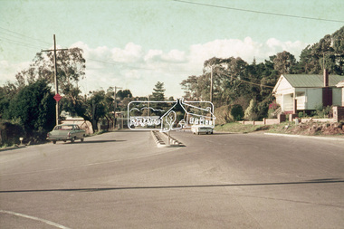
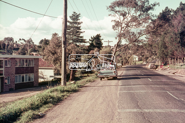
Photograph, Looking northeast along Main Road at intersection with Para Road, Lower Plenty, July 1969, 1969
... Looking northeast along Main Road at intersection with Para Road, Lower Plenty, July 1969...Lower plenty, main road, para road...House on right is 122 Main Road, Lower Plenty viewed from intersection of Main Road with Para Road...Eltham District Historical Society Inc 728 Main Rd Eltham melbourne House on right is 122 Main Road, Lower Plenty viewed from intersection of Main Road with Para Road Lower plenty, main road, para road 35mm colour positive transparency blue Agfacolour Service plastic mount Looking northeast along Main Road at intersection with Para Road, Lower Plenty, July 1969 Photograph ...House on right is 122 Main Road, Lower Plenty viewed from intersection of Main Road with Para Road35mm colour positive transparency blue Agfacolour Service plastic mountlower plenty, main road, para road -
 Eltham District Historical Society Inc
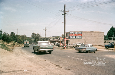
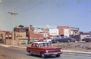
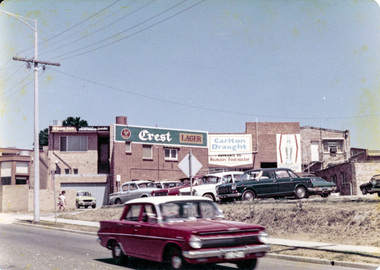
Photograph, Intersection of Para Road with Main Road, Lower Plenty, c.1965, 1965c
... Intersection of Para Road with Main Road, Lower Plenty, c.1965...lower plenty...main road...para road...Eltham District Historical Society Inc 728 Main Rd Eltham melbourne streets lower plenty main road para road shops maunder's food store russell yeoman collection shoe inn Maunder's Food Store Digital file only; created from original colour positive slide transparency Intersection of Para Road with Main Road, Lower Plenty, c.1965 Photograph Russell Yeoman ...Digital file only; created from original colour positive slide transparencystreets, lower plenty, main road, para road, shops, maunder's food store, russell yeoman collection, shoe inn, maunder's food store -
 Eltham District Historical Society Inc
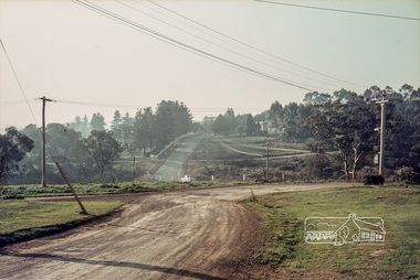
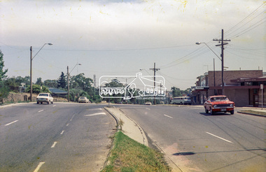
Photograph, Russell Yeoman, Para Road, c.1969, 1969c
... Looking north from behind the Lower Plenty shops at Main Road and Para Road....Eltham District Historical Society Inc 728 Main Rd Eltham melbourne Looking north from behind the Lower Plenty shops at Main Road and Para Road. streets lower plenty para road Russell Yeoman Collection Digital file only; created from original colour positive slide transparency Para Road, c.1969 Photograph Russell Yeoman ...Looking north from behind the Lower Plenty shops at Main Road and Para Road.Digital file only; created from original colour positive slide transparencystreets, lower plenty, para road, russell yeoman collection -
 Eltham District Historical Society Inc
Document - Folder, Stewart, Charles, Annie and family
... Main Rd Eltham melbourne The Stewart family settled at Lower Plenty and ran the Post Office Store as a family business. Contents Handwritten and typed notes: "Steward/Wieland, Early years of Lower Plenty asexperienced by tghe Stewart family". Letter Lynne Towers to EDHS, 18 March 1987. Enquiry for name of Queenstown Cemetery registrar re her ancester Catherine Stewart. Charles David Stewart Annie Grace Stewart Ethel Stewart Rita Stewart Ida Stewart Allanvale sheep station Lower Plenty Post Office Store Para Road Montmorency Looker Road ...The Stewart family settled at Lower Plenty and ran the Post Office Store as a family business. Contents Handwritten and typed notes: "Steward/Wieland, Early years of Lower Plenty asexperienced by tghe Stewart family". Letter Lynne Towers to EDHS, 18 March 1987. Enquiry for name of Queenstown Cemetery registrar re her ancester Catherine Stewart. Newspaper clippings, A4 photocopies, etccharles david stewart, annie grace stewart, ethel stewart, rita stewart, ida stewart, allanvale sheep station, lower plenty post office store, para road montmorency, looker road montmorency, greensborough road, montmorency station, heidelberg club house company, heidelberg golf club, basket ball clubeltham, victorian women's basket ball association, ernie andrews, flo parsons, diamond creek flood 1934, eltham lower park, ted wieland, rita wieland nee stewart -
 Greensborough Historical Society
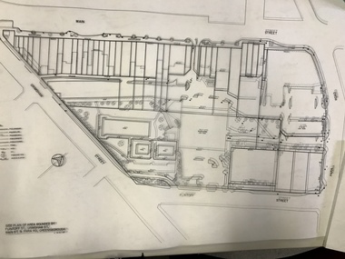
Planning Document, Banyule City Council, Site plan of Greensborough 1997, 28/07/1997
... Greensborough Historical Society 34A Glenauburn Road Lower Plenty Lower Plenty melbourne Site plans for the area bounded by Flintoff Street; Grimshaw Street; Main Street and Para Road Greensborough. these plans show the area before the development of Watermarc. ...Site plans for the area bounded by Flintoff Street; Grimshaw Street; Main Street and Para Road Greensborough. these plans show the area before the development of Watermarc.This plan shows central Greensborough before the Watermarc developmentSet of 8 site plansgreensborough, greensborough swimming pool -
 Greensborough Historical Society
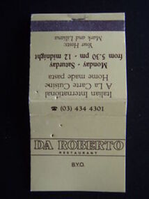
Match Container - Digital Image, Da Roberto Restaurant matchbook, 1980s, 1980s
... Greensborough Historical Society 34A Glenauburn Road Lower Plenty Lower Plenty melbourne Digital image of Da Roberto Restaurant matchbook, circa 1980, used for advertising. Da Roberto was an Italian restaurant situated on the corner of Main Street and Para Road Greensborough. ...Digital image of Da Roberto Restaurant matchbook, circa 1980, used for advertising. Da Roberto was an Italian restaurant situated on the corner of Main Street and Para Road Greensborough.Part of a collection of miscellaneous historical images with a connection to the local area.Digital image of paper matchbook."Da Roberto Restaurant ..." da roberto restaurant -
 Greensborough Historical Society
Photograph - Digital Image, Grimshaw Street Safeway store, 1975c
... Greensborough Historical Society 34A Glenauburn Road Lower Plenty Lower Plenty melbourne This photograph shows the original Safeway store in Grimshaw Street Greensborough. The first Woolworths store was located at the corner of Main Street and Para Road c1978. ...This photograph shows the original Safeway store in Grimshaw Street Greensborough. The first Woolworths store was located at the corner of Main Street and Para Road c1978. This store was not a success and may have only lasted a year, after replacing Watson's Car Sale yard which was on the site after Marble Hall was demolished in c1962, taking over the whole corner, including the replacement of Stubley Motors and the Greensborough Newsagent.This store has been replaced by a 'new' Safeway store.Digital copy of black and white photograph.grimshaw street greensborough, safeway -
 Greensborough Historical Society
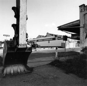
Photograph - Digital image, The demolition of Watson's Garage Greensborough, 1970c
... Greensborough Historical Society 34A Glenauburn Road Lower Plenty Lower Plenty melbourne This image shows the demolition of Watson's Garage circa 1970. Watson's was a well known Greensborough business located on Main Street near Para Road. ...This image shows the demolition of Watson's Garage circa 1970. Watson's was a well known Greensborough business located on Main Street near Para Road.Digital copy of colour photo. -
 Greensborough Historical Society
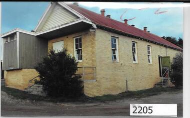
Photographs, Unknown, Lower Plenty Hall, 1960s
... Views of Lower Plenty Hall prior to its demolition to make way for a carpark, near the corner of Para Road and Main Road Lower Plenty....Greensborough Historical Society 34A Glenauburn Road Lower Plenty Lower Plenty melbourne Views of Lower Plenty Hall prior to its demolition to make way for a carpark, near the corner of Para Road and Main Road Lower Plenty. lower plenty hall Collection of 3 colour photographs Lower Plenty Hall Photographs Unknown ...Views of Lower Plenty Hall prior to its demolition to make way for a carpark, near the corner of Para Road and Main Road Lower Plenty.Collection of 3 colour photographslower plenty hall -
 Greensborough Historical Society
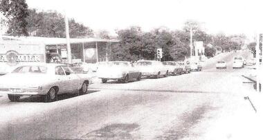
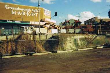
Photograph - Digital image, Para Road Greensborough from the Station, 1975_
... Road Lower Plenty Lower Plenty melbourne Photograph of the intersection of Para Road and Main Street Greensborough circa 1975. Shows the Greensborough Valley Market on the corner and Greensborough Hotel in background. Taken from the Station, the train line can be seen in the foreground. greensborough valley market greensborough station para road ...Photograph of the intersection of Para Road and Main Street Greensborough circa 1975. Shows the Greensborough Valley Market on the corner and Greensborough Hotel in background. Taken from the Station, the train line can be seen in the foreground.Digital copy of colour photograph.greensborough valley market, greensborough station, para road, main street greensborough -
 Greensborough Historical Society
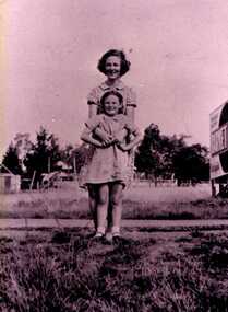
Photograph - Digital image, Miss Flowers and Dorothy Brown, 1940c
... Greensborough Historical Society 34A Glenauburn Road Lower Plenty Lower Plenty melbourne Miss Flowers and Dorothy brown; facing Para Road with Main Road strip behind them. ...Miss Flowers and Dorothy brown; facing Para Road with Main Road strip behind them. Photographs from the collection of Peter Blackbourn, a descendant of the Chapman Stock family. Annotations to photos by Peter Blackbourn.Digital copy of black and white photograph.peter blackbourn, flowers family, dorothy brown -
 Greensborough Historical Society
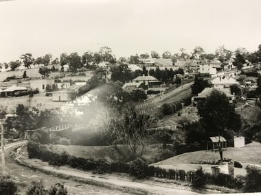
Photograph, Main Road bridge looking to township of Greensborough, 1929c
... Road Lower Plenty Lower Plenty melbourne View of Main Street Greensborough from Partington's Hill including Plenty River bridge and Marble Hall on corner of Carter Street (now Para Road) and Main Street. This view of Greensborough Park shows the old pan toilets, the hawthorn fence line and the rather undeveloped roadside area of the park. Looking up Main Street we see the old Chapman house at the corner of Poulter Avenue and some newer houses below this. The stone river bridge appears to be only a single lane wide and the road ...View of Main Street Greensborough from Partington's Hill including Plenty River bridge and Marble Hall on corner of Carter Street (now Para Road) and Main Street. This view of Greensborough Park shows the old pan toilets, the hawthorn fence line and the rather undeveloped roadside area of the park. Looking up Main Street we see the old Chapman house at the corner of Poulter Avenue and some newer houses below this. The stone river bridge appears to be only a single lane wide and the road approaching the bridge is unsealed. The rail bridge shows evidence of soot from steam trains and at the extreme left of picture the two concrete buildings indicate the line had been electrified. This occurred in 1923. Sparse housing is seen in the Flintoff Street and Grimshaw Street area.Part of a collection of photographic enlargements of views of Greensborough in the early 1900s.Black and white enlargement of photographic imagemain street greensborough, marble hall, greensborough railway, chapman house, greensborough park, poulter avenue greensborough, carter street, para road -
 Greensborough Historical Society
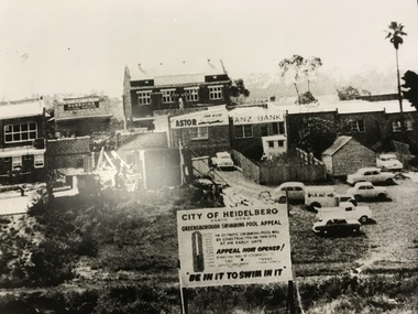
Photograph, Greensborough Pool site, 1959c
... Road Lower Plenty Lower Plenty melbourne The site of the Greensborough swimming pool taken from the corner of Grimshaw Street and Para Road. The barometer board shows the amount needed by public subscription. The two storey hall in the centre back had been the Rechabite Hall, later Masonic Hall then Ashril Theatre. The picture also shows the undeveloped nature of the area behind the Main ...The site of the Greensborough swimming pool taken from the corner of Grimshaw Street and Para Road. The barometer board shows the amount needed by public subscription. The two storey hall in the centre back had been the Rechabite Hall, later Masonic Hall then Ashril Theatre. The picture also shows the undeveloped nature of the area behind the Main St shops. This area was later sealed and made into the Carter car parking reserve. Part of a collection of photographic enlargements of Greensborough sites.Black and white enlargement of photographic imagegreensborough swimming pool, rechabite hall greensborough, ashril theatre -
 Greensborough Historical Society
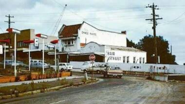
Article and Photograph, Greensborough 1970s, 2016_
... Road Lower Plenty Lower Plenty melbourne Information and photo of intersection of Main Street and Para Road Greensborough in the 1970s. This photograph and text was copied from a Facebook site. Members are people who lived in the Greensborough area and share their reminiscences of the area with others. The site is administered by a GHS member but is not officially affiliated with the Society. Any information is the opinion of the contributor. greensborough main street greensborough para road ...Information and photo of intersection of Main Street and Para Road Greensborough in the 1970s. This photograph and text was copied from a Facebook site. Members are people who lived in the Greensborough area and share their reminiscences of the area with others. The site is administered by a GHS member but is not officially affiliated with the Society. Any information is the opinion of the contributor. Article and photograph sourced from social media.greensborough, main street greensborough, para road greensborough -
 Greensborough Historical Society
Photograph - Photograph - Digital Image, Main Street bridge Greensborough 1970s, 1970s
... Greensborough Historical Society 34A Glenauburn Road Lower Plenty Lower Plenty melbourne A colour photograph of the corner of Para Road and Main Street Greensborough in the 1970s, during the duplication and construction of the bridge over the Plenty River. main street greensborough para road greensborough plenty river bridge Digital copy of colour photograph. ...A colour photograph of the corner of Para Road and Main Street Greensborough in the 1970s, during the duplication and construction of the bridge over the Plenty River.Digital copy of colour photograph.main street greensborough, para road greensborough, plenty river bridge -
 Eltham District Historical Society Inc
Album - Photograph Album, J.A. McDonald, Bridge and Road Reconstruction Works, Shire of Eltham, 1952-1962
... Road...Grand Hotel...Haldane Road...Healesville...Healesville-Yarra Glen Road...Heidelberg-Kinglake Road...Henley Road Bridge...Henley Road...Hill property...Hurstbridge Water scheme...Hurstbridge...Hurstbridge-Arthurs Creek Road...Infrastructure...J. Jolly...Kangaroo Ground...Kangaroo Ground-Queenstown Road...Kangaroo Ground-St Andrews Road...Lilydale Shire Office...Long Gully Bridge...Long Gully Creek...Long Gully Road...Long Gully...Lower Plenty Bridge...Lower Plenty Footbridge...Lower Plenty Oval...Lower Plenty Road...Lower Plenty...Main Road...Methodist Church...Montmorency...Mount Pleasant Road...New Holland...Old Healesville Road...Opening Ceremony...Oxley Bridge...Para...Road Grand Hotel Haldane Road Healesville Healesville-Yarra Glen Road Heidelberg-Kinglake Road Henley Road Bridge Henley Road Hill property Hurstbridge Water scheme Hurstbridge Hurstbridge-Arthurs Creek Road Infrastructure J. Jolly Kangaroo Ground Kangaroo Ground-Queenstown Road Kangaroo Ground-St Andrews Road Lilydale Shire Office Long Gully Bridge Long Gully Creek Long Gully Road Long Gully Lower Plenty Bridge Lower Plenty Footbridge Lower Plenty Oval Lower Plenty Road Lower Plenty Main Road Methodist Church Montmorency Mount Pleasant Road New Holland Old Healesville Road Opening Ceremony Oxley Bridge Para Road Paul Creek Bridge Paul Creek Road Paul Krafeznk Pinnacle Lane Plaques Plenty River Trail Plenty River Presbyterian Church Prof Donald Thomson Pryor Street railway crossing Railway Parade Rattray Road Reconstruction works Reichelt Avenue Research (Vic.) ...J.A. McDonald produced this record in the course of his responsibilities as Shire Engineer for Eltham Shire Council.Record of various Shire of Eltham infrastructure works undertaken during the period of 1952-1962 involving bridge and road reconstruction projects, sometimes with Eltham Shire Council Project Reference numbers quoted. It was during this period that a number of significant improvements were made to roads and new bridges constructed within the shire that remain in place as of present day (2022). In many situations, the photos provide a tangible visible record of infrastructure that existed throughout the early days of the Shire. The album was put together by or under the direction of the Shire Engineer, J.A. McDonald.a. gillies, alistair knox park, benchmark studies, bend of islands, blease road, box hill state school, box hill teachers college, box hill tip, bridge construction, bridge street bridge, bridge, brisbane street, brougham steet, bulldozer, cecil street, charis pelling, cherry tree road, city of preston, cr. a. brinkkotter, cr. charis pelling, cranes, cromwell street, diamond creek (creek), diamond street, dixons creek bridge, dixon's creek road, drott, eltham leisure centre, eltham north, eltham police station, eltham, eltham-yarra glen road, f. wood, fitzsimons lane bridge, flat rock road, flood damage, floods, floodwater, footpaths and gutters, ford service garage, g. blair, garden hill, glen park bridge, glenauburn road, grand hotel, haldane road, healesville, healesville-yarra glen road, heidelberg-kinglake road, henley road bridge, henley road, hill property, hurstbridge water scheme, hurstbridge, hurstbridge-arthurs creek road, infrastructure, j. jolly, kangaroo ground, kangaroo ground-queenstown road, kangaroo ground-st andrews road, lilydale shire office, long gully bridge, long gully creek, long gully road, long gully, lower plenty bridge, lower plenty footbridge, lower plenty oval, lower plenty road, lower plenty, main road, methodist church, montmorency, mount pleasant road, new holland, old healesville road, opening ceremony, oxley bridge, para road, paul creek bridge, paul creek road, paul krafeznk, pinnacle lane, plaques, plenty river trail, plenty river, presbyterian church, prof donald thomson, pryor street, railway crossing, railway parade, rattray road, reconstruction works, reichelt avenue, research (vic.), research oval, road construction, rymers corner, shire of eltham, shire of whittlesea, silvan road bridge, silver street bridge, silver street, sir dallas brooks, smedley property, st andrews, steels creek, susan street, tarrawarra, tony carberry, uniting church, upper yarra dam, upper yarra reservoir, w.e. wolf, waterfall property, watsons creek, wattletree road bridge, wattletree road, wattletree road bridge, worlingworth, yarra glen, york street, yow yow creek -
 Eltham District Historical Society Inc
Slide - Photograph, Lees Road, Lower Plenty, c.May1990
... Eltham District Historical Society Inc 728 Main Rd Eltham melbourne roads lees road para road Processing Date Code Jun 90M 35mm colour positive transparency (1 of 25) Mount - Kodak Ektachrome Lees Road, Lower Plenty Slide Photograph ...35mm colour positive transparency (1 of 25) Mount - Kodak EktachromeProcessing Date Code Jun 90Mroads, lees road, para road -
 Eltham District Historical Society Inc
Slide - Photograph, Aerial Photo (c.1987): Sherbourne Road overpass, Briar Hill, c.Aug. 1990
... Main Rd Eltham melbourne Part of a presentation, "Roads and Byways of the Shire of Eltham", by Russell Yeoman to the 12 September 1990 Society meeting. Slides shown included copies of old photos and recent images ranging from the suburban streets of Eltham and Montmorency to the mountain roads of Kinglake. In the byways category are views of some iof the Shire's bicycle paths including then recently completed sections of the Main Yarra Trail at Lower Plenty. infrastructure roads aerial photographs Briar Hill Overpass Para ...Part of a presentation, "Roads and Byways of the Shire of Eltham", by Russell Yeoman to the 12 September 1990 Society meeting. Slides shown included copies of old photos and recent images ranging from the suburban streets of Eltham and Montmorency to the mountain roads of Kinglake. In the byways category are views of some iof the Shire's bicycle paths including then recently completed sections of the Main Yarra Trail at Lower Plenty.35mm colour positive transparency (1 of 37) Mount - Agfachrome Agfa CS System black 8 dotsinfrastructure, roads, aerial photographs, briar hill, overpass, para road, railway bridge, sherbourne road -
 Eltham District Historical Society Inc
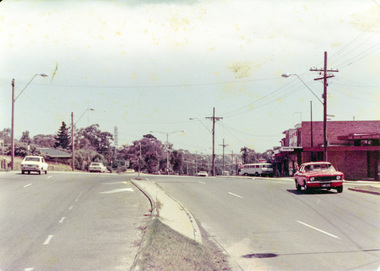
Photograph, Looking northeast along Main Road near intersection with Para Road, Lower Plenty, July 1969, 1969
... Looking northeast along Main Road near intersection with Para Road, Lower Plenty, July 1969...Eltham District Historical Society Inc 728 Main Rd Eltham melbourne lower plenty, main road 35mm colour positive transparency blue Agfacolour Service plastic mount Looking northeast along Main Road near intersection with Para Road, Lower Plenty, July 1969 Photograph ...35mm colour positive transparency blue Agfacolour Service plastic mountlower plenty, main road -
 Eltham District Historical Society Inc
Photograph, Rear view of Lower Plenty shops from Para Road, c.1976, 1976c
... Eltham District Historical Society Inc 728 Main Rd Eltham melbourne Streetscape development over time para road lower plenty shops shoe inn maunder's food store Agfa CNS Roll of 35mm colour negative film, 2 strips Rear view of Lower Plenty shops from Para Road, c.1976 Photograph ...Streetscape development over timeRoll of 35mm colour negative film, 2 stripsAgfa CNSpara road, lower plenty, shops, shoe inn, maunder's food store -
 Eltham District Historical Society Inc
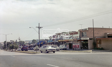
Photograph, Para Road and Main Road, Lower Plenty, c.1976, 1976c
... Para Road and Main Road, Lower Plenty, c.1976...para road...lower plenty...shops...main road...Eltham District Historical Society Inc 728 Main Rd Eltham melbourne Streetscape development over time para road lower plenty shops main road shoe inn maunder's food store Agfa CNS Roll of 35mm colour negative film, 2 strips Para Road and Main Road, Lower Plenty, c.1976 Photograph ...Streetscape development over timeRoll of 35mm colour negative film, 2 stripsAgfa CNSpara road, lower plenty, shops, main road, shoe inn, maunder's food store -
 Eltham District Historical Society Inc
Photograph, Para Road and Main Road, Lower Plenty, c.1976, 1976c
... Para Road and Main Road, Lower Plenty, c.1976...para road...lower plenty...shops...main road...Eltham District Historical Society Inc 728 Main Rd Eltham melbourne Streetscape development over time para road lower plenty shops main road Colour photograph Para Road and Main Road, Lower Plenty, c.1976 Photograph ...Streetscape development over timeColour photographpara road, lower plenty, shops, main road -
 Eltham District Historical Society Inc
Photograph, Rear view of Lower Plenty shops from Para Road, c.1976, 1976c
... Eltham District Historical Society Inc 728 Main Rd Eltham melbourne Streetscape development over time para road lower plenty shops Colour photopgraph Rear view of Lower Plenty shops from Para Road, c.1976 Photograph ...Streetscape development over timeColour photopgraphpara road, lower plenty, shops -
 Eltham District Historical Society Inc
Photograph, Para Road and Main Road, Lower Plenty, c.1976, 1976c
... Para Road and Main Road, Lower Plenty, c.1976...para road...lower plenty...shops...main road...Eltham District Historical Society Inc 728 Main Rd Eltham melbourne Streetscape development over time para road lower plenty shops main road shoe inn maunder's food store Agfa CNS Roll of 35mm colour negative film, 2 strips Para Road and Main Road, Lower Plenty, c.1976 Photograph ...Streetscape development over timeRoll of 35mm colour negative film, 2 stripsAgfa CNSpara road, lower plenty, shops, main road, shoe inn, maunder's food store -
 Eltham District Historical Society Inc
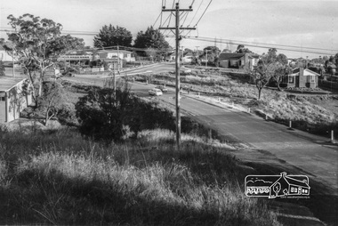
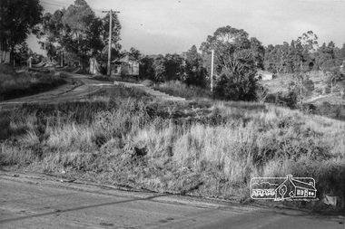
Photograph, Looking south along Para Road at intersection of Alma Street and Lees Road, Lower Plenty, c.July 1967, 1967
... Main Rd Eltham melbourne Old community hall (long wall with row of windows) and Lower Plenty Kindergarten visible at corner of Glenauburn and Para Roads. Packaged in "Filmpro King Size prints Definitely Better EST. 1918" envelope. Pencil notes: 36 shots $2.87 Eltham Shire J. McD and 19/7/67. Alma Street and Kett Street Lower Plenty c.July 1967. alma street glenauburn road ...Old community hall (long wall with row of windows) and Lower Plenty Kindergarten visible at corner of Glenauburn and Para Roads. Packaged in "Filmpro King Size prints Definitely Better EST. 1918" envelope. Pencil notes: 36 shots $2.87 Eltham Shire J. McD and 19/7/67. Alma Street and Kett Street Lower Plenty c.July 1967.Black and white photographalma street, glenauburn road, carisbrook crescent, lees road, lower plenty, lower plenty kindergarten, para road, houses, streets -
 Eltham District Historical Society Inc
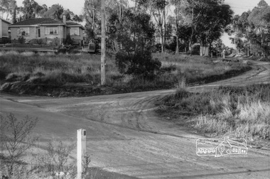
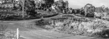
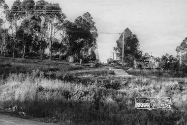
Photograph, Looking northeast up Alma Street from Para Road at intersection of Alma Street and Lees Road, Lower Plenty, c.July 1967, 1967
... Main Rd Eltham melbourne Packaged in "Filmpro King Size prints Definitely Better EST. 1918" envelope. Pencil notes: 36 shots $2.87 Eltham Shire J. McD and 19/7/67. Alma Street and Kett Street Lower Plenty c.July 1967. alma street lees road lower plenty para road houses streets Black and white photograph Looking northeast up Alma Street from Para Road at intersection of Alma Street and Lees Road, Lower Plenty, c.July 1967 Photograph ...Packaged in "Filmpro King Size prints Definitely Better EST. 1918" envelope. Pencil notes: 36 shots $2.87 Eltham Shire J. McD and 19/7/67. Alma Street and Kett Street Lower Plenty c.July 1967.Black and white photographalma street, lees road, lower plenty, para road, houses, streets -
 Eltham District Historical Society Inc
Photograph, Looking northeast up Alma Street from Para Road at intersection of Alma Street and Lees Road, Lower Plenty, c.July 1967, 1967
... Main Rd Eltham melbourne Packaged in "Filmpro King Size prints Definitely Better EST. 1918" envelope. Pencil notes: 36 shots $2.87 Eltham Shire J. McD and 19/7/67. Alma Street and Kett Street Lower Plenty c.July 1967. alma street lees road lower plenty para road houses streets Digital composite of two black and white photographs Looking northeast up Alma Street from Para Road at intersection of Alma Street and Lees Road, Lower Plenty, c.July 1967 Photograph ...Packaged in "Filmpro King Size prints Definitely Better EST. 1918" envelope. Pencil notes: 36 shots $2.87 Eltham Shire J. McD and 19/7/67. Alma Street and Kett Street Lower Plenty c.July 1967.Digital composite of two black and white photographsalma street, lees road, lower plenty, para road, houses, streets -
 Eltham District Historical Society Inc
Photograph, Looking northeast up Alma Street from Para Road at intersection of Alma Street and Lees Road, Lower Plenty, c.July 1967, 1967
... Main Rd Eltham melbourne Packaged in "Filmpro King Size prints Definitely Better EST. 1918" envelope. Pencil notes: 36 shots $2.87 Eltham Shire J. McD and 19/7/67. Alma Street and Kett Street Lower Plenty c.July 1967. alma street lower plenty para road houses streets Black and white photograph Looking northeast up Alma Street from Para Road at intersection of Alma Street and Lees Road, Lower Plenty, c.July 1967 Photograph ...Packaged in "Filmpro King Size prints Definitely Better EST. 1918" envelope. Pencil notes: 36 shots $2.87 Eltham Shire J. McD and 19/7/67. Alma Street and Kett Street Lower Plenty c.July 1967.Black and white photographalma street, lower plenty, para road, houses, streets -
 Eltham District Historical Society Inc
Photograph, Looking northeast up Alma Street from Para Road at intersection of Alma Street and Lees Road, Lower Plenty, c.July 1967, 1967
... Main Rd Eltham melbourne Packaged in "Filmpro King Size prints Definitely Better EST. 1918" envelope. Pencil notes: 36 shots $2.87 Eltham Shire J. McD and 19/7/67. Alma Street and Kett Street Lower Plenty c.July 1967. alma street lower plenty para road houses streets Black and white photograph Looking northeast up Alma Street from Para Road at intersection of Alma Street and Lees Road, Lower Plenty, c.July 1967 Photograph ...Packaged in "Filmpro King Size prints Definitely Better EST. 1918" envelope. Pencil notes: 36 shots $2.87 Eltham Shire J. McD and 19/7/67. Alma Street and Kett Street Lower Plenty c.July 1967.Black and white photographalma street, lower plenty, para road, houses, streets