Showing 9 items matching "lyrebird track"
-
 Greensborough Historical Society
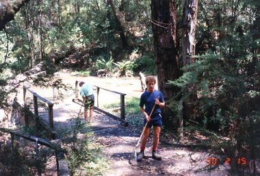
Photograph - Photographs, Carolyn Haas, Janefield Special School: Lyrebird Track clearing 15/02/1990, 15/02/1990
... Janefield Special School: Lyrebird Track clearing 15/02/1990...5 photographs of a Thursday task - clearing the Lyrebird Track. Janefield Special School helped with building and maintaining of this wheelchair friendly track at Kinglake National Park....Janefield Special School: Lyrebird Track clearing 15/02/1990 Photograph Photographs Carolyn Haas ...5 photographs of a Thursday task - clearing the Lyrebird Track. Janefield Special School helped with building and maintaining of this wheelchair friendly track at Kinglake National Park.4 colour photographs. janefield, janefield special school, kinglake national park -
 Greensborough Historical Society
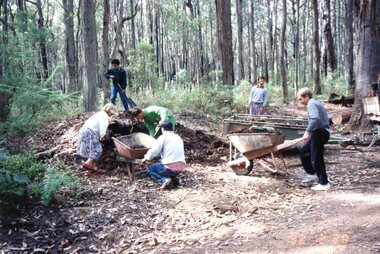
Photograph - Photographs, Carolyn Haas, Janefield Special School: Lyrebird Track maintenance 20/02/1992, 15/02/1990
... Janefield Special School: Lyrebird Track maintenance 20/02/1992...16 photographs of a community task - maintaining the Lyrebird Track in 1992. Janefield Special School helped with building and maintaining of this wheelchair friendly track at Kinglake National Park....Janefield Special School: Lyrebird Track maintenance 20/02/1992 Photograph Photographs Carolyn Haas ...16 photographs of a community task - maintaining the Lyrebird Track in 1992. Janefield Special School helped with building and maintaining of this wheelchair friendly track at Kinglake National Park.16 colour photographs. janefield, janefield special school, kinglake national park -
 Mt Dandenong & District Historical Society Inc.
Photograph
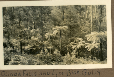
... ...Lyrebird Track...Olinda Falls Falls Lyrebird Lyrebird Gully Lyrebird Track Written below photograph in album: OLINDA FALLS AND LYRE BIRD GULLY Black and white photograph showing a row of tree ferns in the foreground with bush behind. ...Lyre Bird Gully and Lyre Bird Gully Track run alongside the Olinda Falls. The area has been a popular walking track in the from the 1920s onwards. The photograph is from the album of Ivy Child. Ivy May Child (1910 – 1989) was the daughter of Arthur Edward (Ted) Child (1878 – 1964) and Ethel May Madden (1888 – 1970). Ted Child was the son of Matthew Francis Child (1839 – 1933) and Martha Jeeves (1857 – 1926). He was the grandson of one of the early pioneers Francis Child. Ivy grew up on the family property on Childs Road and took many photographs. Most of these are glued into her photo album. The album covered the years from c1927 – 1932. Ivy married Henry William Burgess (1906 – 1968) in 1944. The photographs remain in their original state in the album with individual copies made. Black and white photograph showing a row of tree ferns in the foreground with bush behind.Written below photograph in album: OLINDA FALLS AND LYRE BIRD GULLYolinda falls, falls, lyrebird, lyrebird gully, lyrebird track -
 Eltham District Historical Society Inc
Photograph - Digital Photograph, Alan King, Kinglake National Park, 27 March 2008
... tracks amongst the protected plant and animal life as well as camping, cycling and horse riding. The park, along the slopes of the Great Dividing Range, has lookouts revealing magnificent views of the Melbourne skyline, Port Phillip Bay, the Yarra Valley and the You Yangs. Vegetation in the Masons Falls area includes messmate forest, Austral grass-trees, ferns and Hazel Pomaderris. In spring, orchids, lilies, everlasting daisies, correas, grevillea and heath appear. Around Jehosaphat Gully are wet and dry forest, fern gullies and banksia. Animal life includes wallabies, kangaroos, koalas, echidnas, possums, gliders and bandicoots. Male lyrebirds...tracks amongst the protected plant and animal life as well as camping, cycling and horse riding. The park, along the slopes of the Great Dividing Range, has lookouts revealing magnificent views of the Melbourne skyline, Port Phillip Bay, the Yarra Valley and the You Yangs. Vegetation in the Masons Falls area includes messmate forest, Austral grass-trees, ferns and Hazel Pomaderris. In spring, orchids, lilies, everlasting daisies, correas, grevillea and heath appear. Around Jehosaphat Gully are wet and dry forest, fern gullies and banksia. Animal life includes wallabies, kangaroos, koalas, echidnas, possums, gliders and bandicoots. Male lyrebirds ...Fern gullies around Jehosaphat Gully Covered under National Estate. Published: Nillumbik Now and Then / Marguerite Marshall 2008; photographs Alan King with Marguerite Marshall.; p125 The magnificent Kinglake National Park, fringing Nillumbik’s north, is the largest national park close to Melbourne. Thanks to the vision and hard work of a band of local people, the park was created from what was rapidly becoming degraded land. Seeing a threat to Kinglake’s indigenous flora and fauna, several prominent local people campaigned for a national park, which was established in 1928.1 Since then, the park has grown through donations and acquisitions of land, from around 13,800 acres of land (5585ha) to 22,360 hectares. The Sugarloaf and Everard Blocks – of almost 8000 hectares – stand in Nillumbik and the park extends into Mitchell and Murrundindi Shires and the City of Whittlesea. Mt Everard commemorates William Hugh Everard, State member for Evelyn when the park was established. Before 1928, European settlers had degraded the Kinglake area, which was named after the celebrated English author and lawyer, Alexander William Kinglake. Remains of gold shafts and diggings in the park are reminders of Kinglake’s first settlers, who hoped to strike it rich at the gold diggings. But like other gold fields in this shire, they proved not very lucrative and soon timber cutting replaced mining in importance. However, before long, the accessible timber supply ran out, so in the 1920s agriculture took over – particularly potatoes and berry fruits – which involved large-scale clearing.2 The park’s instigator was retired Melbourne University Professor of Music, William Laver.3 As chair of the Kinglake Progress Association he began negotiations to have crown lands on the southern scarp of the Great Dividing Range reserved as a national park. Even before the park was proclaimed, from 1927, KPA members cut tracks to the major scenic points. Professor Laver was one of several people who gave land for the park, donating around 50 acres (20ha), including the Jehosaphat Gully.4 Laver chaired the park’s first Committee of Management, which raised money to employ a ranger and provide facilities, including tracks and roads for fire protection vehicles, toilets and shelters. The committee charged fees for firewood collection, some grazing of livestock, and visitor entrance, and obtained small State Government and Eltham Shire grants. In 1957 the State Government provided revenue for national parks. Then, in 1975, the State Government took over the management and the Committee of Management became an advisory committee, which disbanded in 1978. Originally, the park covered crown land in the Shires of Eltham and Whittlesea; then Wombelano Falls in Yea and other areas were added. In 1970 the park extended into the Shires of Eltham, Healesville, Whittlesea and Yea.5 Bush fires have been an ongoing problem. In 1939 hundreds of eucalypts and acacias had to be sown around the Jehosaphat Gully to rejuvenate the forest. To manage bushfires, the Committee of Management, then the State Government, worked closely with the Forestry Commission, shire councils and local fire brigades. Early national parks focussed on recreation. But by the 1980s, conservation, education and scientific research became more important, playing a vital role in preserving representative samples of the natural environment. Each year many thousands of people use the park’s extensive network of walking tracks amongst the protected plant and animal life as well as camping, cycling and horse riding. The park, along the slopes of the Great Dividing Range, has lookouts revealing magnificent views of the Melbourne skyline, Port Phillip Bay, the Yarra Valley and the You Yangs. Vegetation in the Masons Falls area includes messmate forest, Austral grass-trees, ferns and Hazel Pomaderris. In spring, orchids, lilies, everlasting daisies, correas, grevillea and heath appear. Around Jehosaphat Gully are wet and dry forest, fern gullies and banksia. Animal life includes wallabies, kangaroos, koalas, echidnas, possums, gliders and bandicoots. Male lyrebirds can be heard mimicking in the Jehosaphat Gully, particularly in the Everard Block in winter.This collection of almost 130 photos about places and people within the Shire of Nillumbik, an urban and rural municipality in Melbourne's north, contributes to an understanding of the history of the Shire. Published in 2008 immediately prior to the Black Saturday bushfires of February 7, 2009, it documents sites that were impacted, and in some cases destroyed by the fires. It includes photographs taken especially for the publication, creating a unique time capsule representing the Shire in the early 21st century. It remains the most recent comprehenesive publication devoted to the Shire's history connecting local residents to the past. nillumbik now and then (marshall-king) collection, kinglake national park, jehosaphat gully -
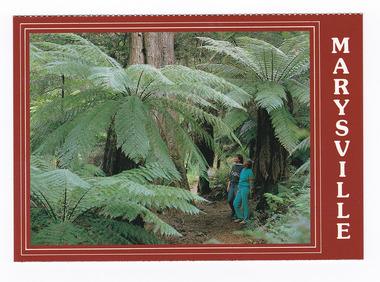
 Marysville & District Historical Society
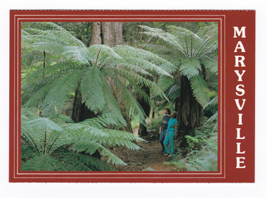
Postcard (item) - Colour postcard, Scancolor (Australia) Pty Ltd, Marysville-Victoria-Australia-Walking track through the "Beeches", Pre 2009
... track through the "Beeches". Starting from the spectacular Taggerty Cascades, the Beeches Rainforest Walk meanders through the ancient cool temperate rainforest of the Yarra Ranges. Dominated by Myrtle Beech trees and stands of Mountain Ash, the rainforest is home to many species of birds including lyrebirds. ...A colour photograph of a couple walking on the track through the "Beeches".A colour photograph of a couple walking on the track through the "Beeches". Starting from the spectacular Taggerty Cascades, the Beeches Rainforest Walk meanders through the ancient cool temperate rainforest of the Yarra Ranges. Dominated by Myrtle Beech trees and stands of Mountain Ash, the rainforest is home to many species of birds including lyrebirds. This postcard was produced by Scancolor Australia as a souvenir of Marysville.MARYSVILLE/ Victoria - Australia Walking track through the "Beeches". scancolor Australia (03) 555 1944/ CS 4067marysville, victoria, the beeches, walking track, scancolor australia, postcard, souvenir -
 Marysville & District Historical Society
Postcard (item) - Colour postcard, Scancolor (Australia) Pty Ltd, Marysville-Victoria-Australia-Walking track through the "Beeches", Pre 2009
... track through the "Beeches". Starting from the spectacular Taggerty Cascades, the Beeches Rainforest Walk meanders through the ancient cool temperate rainforest of the Yarra Ranges. Dominated by Myrtle Beech trees and stands of Mountain Ash, the rainforest is home to many species of birds including lyrebirds. ...A colour photograph of a couple walking on the track through the "Beeches".A colour photograph of a couple walking on the track through the "Beeches". Starting from the spectacular Taggerty Cascades, the Beeches Rainforest Walk meanders through the ancient cool temperate rainforest of the Yarra Ranges. Dominated by Myrtle Beech trees and stands of Mountain Ash, the rainforest is home to many species of birds including lyrebirds. This postcard was produced by Scancolor Australia as a souvenir of Marysville.MARYSVILLE/ Victoria - Australia Walking track through the "Beeches". scancolor Australia (03) 555 1944/ CS 4067marysville, victoria, the beeches, walking track, scancolor australia, postcard, souvenir -
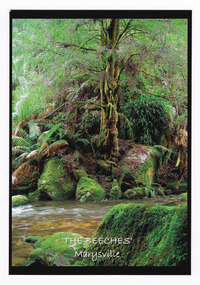 Marysville & District Historical Society
Postcard (item) - Colour postcard, Donovan Wilson, 'The Beeches' Marysville, Pre 2009
... Dominated by Myrtle Beech trees and stands of Mountain Ash, the rainforest is home to many species of birds including lyrebirds. the beeches marysville victoria postcard souvenir donovan wilson walking track Myrtle Beech/ Nothofagus Cunninghamii/ The Beeches/ Marysville Place/ Stamp/ Here Donovan Wilson/ Photography A colour photograph taken at 'The Beeches' near Marysville in Victoria. ...A colour photograph taken at 'The Beeches' near Marysville in Victoria.A colour photograph taken at 'The Beeches' near Marysville in Victoria. Starting from the spectacular Taggerty Cascades, the Beeches Rainforest Walk meanders through the ancient cool temperate rainforest of the Yarra Ranges. Dominated by Myrtle Beech trees and stands of Mountain Ash, the rainforest is home to many species of birds including lyrebirds.Myrtle Beech/ Nothofagus Cunninghamii/ The Beeches/ Marysville Place/ Stamp/ Here Donovan Wilson/ Photographythe beeches, marysville, victoria, postcard, souvenir, donovan wilson, walking track -
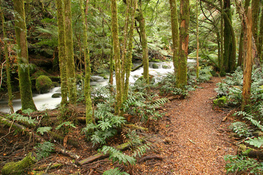 Marysville & District Historical Society
Photograph (item) - Colour photograph, 20-09-2008
... track...marysville...victoria...taggerty river...taggerty cascades...yarra ranges...myrtle beech...mountain ash...lyrebird... which live on the forest floor. beeches rainforest walking track marysville victoria taggerty river taggerty cascades yarra ranges myrtle beech mountain ash lyrebird A colour photograph of the Beeches Rainforest Walking Track near Marysville in Victoria. ...A colour photograph of the Beeches Rainforest Walking Track near Marysville in Victoria.A colour photograph of the Beeches Rainforest Walking Track near Marysville in Victoria. Starting from the spectacular Taggerty Cascades, the Beeches Rainforest Walk meanders through the ancient cool temperate rainforest of the Yarra Ranges. Dominated by Myrtle Beech trees and stands of Mountain Ash, it is home to the lyrebird which live on the forest floor.beeches rainforest walking track, marysville, victoria, taggerty river, taggerty cascades, yarra ranges, myrtle beech, mountain ash, lyrebird -
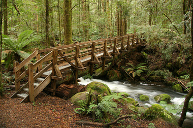 Marysville & District Historical Society
Photograph (item) - Colour photograph, 20-09-2008
... track...marysville...victoria...taggerty river...taggerty cascades...yarra ranges...myrtle beech...mountain ash...lyrebird...Track near Marysville in Victoria. Starting from the spectacular Taggerty Cascades, the Beeches Rainforest Walk meanders through the ancient cool temperate rainforest of the Yarra Ranges. Dominated by Myrtle Beech trees and stands of Mountain Ash, it is home to the lyrebird ...A colour photograph of a wooden bridge over the Taggerty River that is part of the Beeches Rainforest Walk near Marysville in Victoria.A colour photograph of the Beeches Rainforest Walking Track near Marysville in Victoria. Starting from the spectacular Taggerty Cascades, the Beeches Rainforest Walk meanders through the ancient cool temperate rainforest of the Yarra Ranges. Dominated by Myrtle Beech trees and stands of Mountain Ash, it is home to the lyrebird which live on the forest floor.beeches rainforest walking track, marysville, victoria, taggerty river, taggerty cascades, yarra ranges, myrtle beech, mountain ash, lyrebird