
Showing 4 items matching "lysterfield reservoir"
-
 Narre Warren and District Family History Group
Book, Graeme Butler & Associates, City of Casey Heritage Study : Environmental History, 1998
... Lysterfield Reservoir...The Shire of Berwick evolved into the City of Berwick in 1973, and later merged with parts of Cranbourne Shire to form the City of Casey in 1994. Lysterfield Reservoir Koo Wee Rup Swamp Berwick (Vic.) ...A comprehensive environmental history of the City of Casey, covering its heritage, development, and key historical aspects. Some of the themes explored are: 1. Explorers and First Contact 2. Peopling the Continent 3. Promoting Settlement 4. Developing Primary Production 5. Exploiting Natural Resources 6. Building Settlements 7. Governing and Administrative Structures 8. Altering the Environment 9. Communication and Transport 10. Education 11. Recreation 12. Manufacturing The study highlights the rich history and development of the City of Casey, showcasing its transformation from a region of Aboriginal occupation and pastoral runs to a modern city with diverse industries, residential estates, and cultural heritage. This publication can be downloaded from the City of Casey website.non-fictionA comprehensive environmental history of the City of Casey, covering its heritage, development, and key historical aspects. Some of the themes explored are: 1. Explorers and First Contact 2. Peopling the Continent 3. Promoting Settlement 4. Developing Primary Production 5. Exploiting Natural Resources 6. Building Settlements 7. Governing and Administrative Structures 8. Altering the Environment 9. Communication and Transport 10. Education 11. Recreation 12. Manufacturing The study highlights the rich history and development of the City of Casey, showcasing its transformation from a region of Aboriginal occupation and pastoral runs to a modern city with diverse industries, residential estates, and cultural heritage. This publication can be downloaded from the City of Casey website.lysterfield reservoir, koo wee rup swamp, berwick (vic.), endeavour hills (vic.), cranbourne (vic.), narre warren north (vic.), tooradin (vic.), hampton park (vic.), doveton (vic.) -
 Southern Sherbrooke Historical Society Inc.
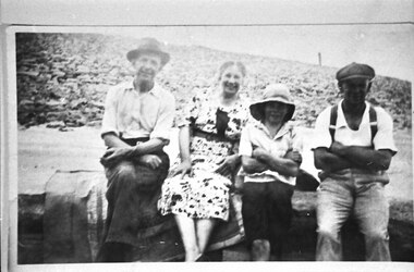
Photograph - Bill Slingo Senior and Junior, Ann Lord and Bill Lord
... Photograph features a Graham Paige car at Lysterfield Reservoir. Bill Lord is dressed in dark trousers, open-necked shirt (with rolled-up sleeves), and a fedora. ...Photograph features a Graham Paige car at Lysterfield Reservoir. Bill Lord is dressed in dark trousers, open-necked shirt (with rolled-up sleeves), and a fedora. ...Photograph features a Graham Paige car at Lysterfield Reservoir. Bill Lord is dressed in dark trousers, open-necked shirt (with rolled-up sleeves), and a fedora. Ann Lord in a patterned summer dress. Bill Slingo junior in dark shorts, light shirt and sunhat, and Bill Slingo Senior in trousers with braces, a white shirt and a peaked cap. They are seated on a bench or wall. The Lords are seated on a satin-edged blanket. Behind the group a dam wall is visible. Photo was most likely taken by Alice Lord on the same day as VSSHP0267.03. . -
 Southern Sherbrooke Historical Society Inc.
Information folder - Dandenong Ranges Steiner School, 2007
... dandenong ranges steiner school menzies creek hall menzies creek shop melbourne water buildings cardinia reservoir "For Lisa Hall" written in blue ink at top of page Information folder containing items pertaining to the Dandenong Ranges Steiner School, Menzies Creek & Lysterfield. ...Information folder containing items pertaining to the Dandenong Ranges Steiner School, Menzies Creek & Lysterfield. Contents:/- typescript, "The Dandenong Ranges Steiner School", a brief history of the school written by Louise Reidsimmons for Lisa Hall's update of Menzies Creek Primary School's centenary book, n.d. but c. 2007, one sheet."For Lisa Hall" written in blue ink at top of pagedandenong ranges steiner school, menzies creek hall, menzies creek shop, melbourne water buildings, cardinia reservoir -
Emerald Museum & Nobelius Heritage Park
Book - Survey book, E. Whitehead & Co. Stationers & Printers, 1920s
... Obverse: A / Field Book / A / Page / 1-6 Macclesfield Road 16-11-20 / 7-8 Reservoir Rd (check levels) 25.11.20 / 9-10 Patch Rd 2-12-20 / 11 Drain from Rly to Jamiesons UFG / 4-12-20 / 12-24 Field's Contract (check) / 25-29 Perrin's Creek also see pge 43 / 30- Rd thro Nightingales Emerald / 31-42 amendment Reservoir Rd 30-3-21 / 44-48 Contour Survey. Lysterfield Narree Warren / 49. ...Emerald Victoria Australia roads and streets surveying land surveys Macclesfield Victoria Australia Narre Warren Victoria Australia Obverse: A / Field Book / A / Page / 1-6 Macclesfield Road 16-11-20 / 7-8 Reservoir Rd (check levels) 25.11.20 / 9-10 Patch Rd 2-12-20 / 11 Drain from Rly to Jamiesons UFG / 4-12-20 / 12-24 Field's Contract (check) / 25-29 Perrin's Creek also see pge 43 / 30- Rd thro Nightingales Emerald / 31-42 amendment Reservoir Rd 30-3-21 / 44-48 Contour Survey. Lysterfield Narree Warren / 49. ...This book holds outstanding historic significance as it speaks to the development and urbanisation of outer eastern Melbourne. In mapping the terrain of the Dandenong foothills, this surveyor book played a big role in laying the foundations for the roads and suburbs in the area. The record's interpretive capacity is strengthened by its position with a museum dedicated to collecting, documenting and preserving the history of Emerald and surrounding districts. There is strong research potential once knowledge of the techniques used by the surveyor are unlocked, revealing a better understanding of the data.This field book contains comprehensive, handwritten survey data, including measurements and annotations, regarding the shapes, angles and curves of roads in Emerald and surrounding districts. The first entry refers to Macclesfield Rd in Victoria, dated 16 November 1920. Data captured includes back sight, intermediate, fore sight, rise, fall, reduced levels, distance, cross section left and right, as well as general remarks and comments. In addition to this quantitative data, there are also hand drawn diagrams of angles and roads scattered throughout the book. Locations mentioned in the book include Macclesfield Rd, Reservoir Rd, Patch Rd, Upper Ferntree Gully, Perrin's Creek and Sandels Rd, among others.Portrait-orientated leather-bound book with printed pages and handwritten notes with graphite pencil. Approximately 60 pages.Obverse: A / Field Book / A / Page / 1-6 Macclesfield Road 16-11-20 / 7-8 Reservoir Rd (check levels) 25.11.20 / 9-10 Patch Rd 2-12-20 / 11 Drain from Rly to Jamiesons UFG / 4-12-20 / 12-24 Field's Contract (check) / 25-29 Perrin's Creek also see pge 43 / 30- Rd thro Nightingales Emerald / 31-42 amendment Reservoir Rd 30-3-21 / 44-48 Contour Survey. Lysterfield Narree Warren / 49. Sandels Road 21-7-21 / 50-55 Not used / 56 Reservoir Road /emerald, victoria, australia, roads and streets, surveying, land surveys, macclesfield victoria australia, narre warren victoria australia
