Showing 7 items matching "maddingley victoria history"
-
 Bacchus Marsh & District Historical Society
Map, Maddingley Township, Parish of Parwan, 1880s
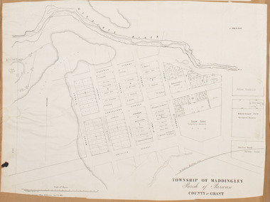
... Maddingley Victoria Maps...Land Use...Maddingley Victoria History...Bacchus Marsh Victoria Maps Maddingley Victoria Maps Land Use Maddingley Victoria History Bottom of Map: Surveyor-General's Office, Melbourne, Sept 6th, 1856 A single page paper map showing land allotments, streets, rivers, creeks, park lands, the railway line and Bacchus Marsh railway station in the township of Maddingley. ...This map is dated Sept. 6th 1856. However places in the township of Maddingley which did not appear until the late 1880s such as the Bacchus Marsh Railway Station and line are shown on this map in their correct locations. This suggests the map has been derived from an earlier map. An earlier date of 1843 with a surveyor's name preceding it can also be seen on the map. The map is important because it indicates the location and dimensions of early but now discontinued use of land such as the showgrounds and police paddock and a site reserved for the Church of England which was not ultimately used for a permanent church. A single page paper map showing land allotments, streets, rivers, creeks, park lands, the railway line and Bacchus Marsh railway station in the township of Maddingley. The map is pasted into a bound volume containing 76 maps or plans in total. Bottom of Map: Surveyor-General's Office, Melbourne, Sept 6th, 1856bacchus marsh victoria maps, maddingley victoria maps, land use, maddingley victoria history -
 Bacchus Marsh & District Historical Society
Map, Gaynor Street Land Sales, Maddingley, circa 1880s-1890s
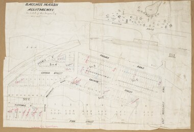
... Maddingley Victoria Maps...Land Use...Maddingley Victoria History...Maddingley area of Bacchus Marsh. The precise date of the sale has not been determined. Features present on the map such as the Bacchus Marsh Railway Station indicate the land sale must have taken place some time after 1887 when the Railway Station opened. Bacchus Marsh Victoria Maps Maddingley Victoria Maps Land Use Maddingley Victoria History ...This map was produced for a major sale of land in the Maddingley area of Bacchus Marsh. The precise date of the sale has not been determined. Features present on the map such as the Bacchus Marsh Railway Station indicate the land sale must have taken place some time after 1887 when the Railway Station opened. A single page paper map showing land allotments for sale in the Maddingley area of Bacchus Marsh. Locations shown include Gaynor Street, Maddingley Road South, Parwan Road, Mitchem Street, Typpynge Street, Finn Street and East Maddingley Road. . The map is pasted into a bound volume containing 76 maps or plans in total. High resolution digital image stored on BMDHS computer network. bacchus marsh victoria maps, maddingley victoria maps, land use, maddingley victoria history, land sales bacchus marsh, land sales maddingley -
 Bacchus Marsh & District Historical Society
Map, Gaynor Street Area Land Sales, Maddingley, 1888
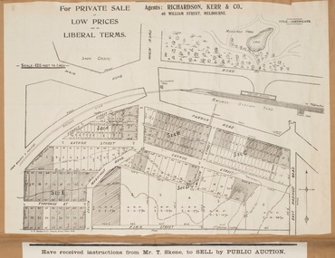
... Maddingley Victoria Maps...Land Use...Maddingley Victoria History...Maddingley area of Bacchus Marsh in 1888. The sale was conducted by two firms from Melbourne, Carney and Kelly 12 Swanston Street Melbourne. and 'Richardson, Kerr & Co. 40 Flinders Lane Melbourne. 136 blocks were for sale. Bacchus Marsh Victoria Maps Maddingley Victoria Maps Land Use Maddingley Victoria History ...This map was produced for a major sale of land in the Maddingley area of Bacchus Marsh in 1888. The sale was conducted by two firms from Melbourne, Carney and Kelly 12 Swanston Street Melbourne. and 'Richardson, Kerr & Co. 40 Flinders Lane Melbourne. 136 blocks were for sale.A single page paper map showing land allotments for sale in the Maddingley area of Bacchus Marsh. Locations shown include Gaynor Street, Maddingley Road South, Parwan Road, Mitchem Street, Typpynge Street, Finn Street and East Maddingley Road. . The map is pasted into a bound volume containing 76 maps or plans in total. High resolution digital image stored on BMDHS computer network. bacchus marsh victoria maps, maddingley victoria maps, land use, maddingley victoria history, land sales bacchus marsh, land sales maddingley -
 Bacchus Marsh & District Historical Society
Map, Maddingley Township, Parish of Parwan, circa 1890s
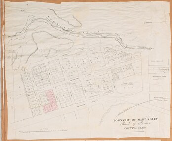
... Maddingley Victoria Maps...Land Use...Maddingley Victoria History...Maddingley Road. Other streets visible are Franklin Street, Inglis Street, Labilliere Street, McCrae Street, Moore Street and part of Station Street. Bacchus Marsh Victoria Maps Maddingley Victoria Maps Land Use Maddingley Victoria History A single page paper map showing land allotments, streets, rivers, creeks, park lands, the railway line and Bacchus Marsh railway station in the township of Maddingley. ...Maddingley is a locality or township within the broader township area of Bacchus Marsh. This map is not dated. However features in Maddingley which appeared in the 1880s and 1890s are present in the map, These include the Bacchus Marsh Railway Station and the Bacchus Marsh Showgrounds. The main residential and commercial area of Maddingley is shown on this map in an area bounded by Bacchus Street, Barry Street, Griffith Street and Maddingley Road. Other streets visible are Franklin Street, Inglis Street, Labilliere Street, McCrae Street, Moore Street and part of Station Street.A single page paper map showing land allotments, streets, rivers, creeks, park lands, the railway line and Bacchus Marsh railway station in the township of Maddingley. The map is pasted into a bound volume containing 76 maps or plans in total. bacchus marsh victoria maps, maddingley victoria maps, land use, maddingley victoria history -
 Bacchus Marsh & District Historical Society
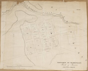
Map, Maddingley Township, Parish of Parwan, County of Grant, 1856
... Maddingley Victoria Maps...Land Use...Maddingley Victoria History...Maddingley shown on this map is an area bounded by Bacchus Street, Moore Street, Griffith Street and Franklin Street. Other streets visible are Inglis Street, Labilliere Street, McCrae Street. The area to the east of Franklin Street is not sub-divided and is described as an 'alluvial flat. Bacchus Marsh Victoria Maps Maddingley Victoria Maps Land Use Maddingley Victoria History ...Maddingley is a locality or township within the broader township area of Bacchus Marsh. This map is dated 1856 but is based on an earlier survey in 1843. The main area of Maddingley shown on this map is an area bounded by Bacchus Street, Moore Street, Griffith Street and Franklin Street. Other streets visible are Inglis Street, Labilliere Street, McCrae Street. The area to the east of Franklin Street is not sub-divided and is described as an 'alluvial flat. A single page paper map showing land allotments, streets, and natural watercourses in the township of Maddingley. The map is pasted into a bound volume containing 76 maps or plans in total. Two inscriptions: 1. A.J. Skene Surveyor, 1843. ; 2. Surveyor-General's Office Melbourne, Sept 6, 1856. (Lithographed by R. Meikle)bacchus marsh victoria maps, maddingley victoria maps, land use, maddingley victoria history -
![Map, Ballarat and Gordons Lane Plan of Land required [for railway line work]](/media/collectors/5e461d8021ea67224c82f2a1/items/676ff3a62c3783fe00b96a8d/item-media/676ff4a42c3783fe00b96cb6/item-fit-380x285.jpg?cb=6) Bacchus Marsh & District Historical Society
Bacchus Marsh & District Historical SocietyMap, Ballarat and Gordons Lane Plan of Land required [for railway line work]
... Bacchus Marsh Victoria History...Maddingley...Bacchus Marsh Victoria History Maddingley Victoria History Railway Lines Single page map showing land required for railway line work near Griffith Street, Bacchus Marsh. ...The railway line from Melbourne to Bacchus Marsh was completed in February 1887. After this date work continued to extend the line to Ballan. This map indicates a portion of land only a few hundred metres west of the Bacchus Marsh railway station which would have been among the first stages of the line to Ballan to have been constructed. This suggests the date of this map to be in the late 1880s.Single page map showing land required for railway line work near Griffith Street, Bacchus Marsh. Scale 10 chains to 1 inch. Hand-written on the map are the exact distances between Bacchus Marsh and Gordons (Gordon) and between Bacchus Marsh and Melbourne as measured from the corner of Maddingley Road and Station Street. Distances recorded are in miles, chains and links. The land required for the railway works is marked in red ink and runs through an area known as Kennedy's Gully. Part of a set of maps which are pasted into a bound volume containing 76 maps or plans in total. High resolution digital image stored on BMDHS computer network. bacchus marsh victoria history, maddingley victoria history, railway lines -
 Bacchus Marsh & District Historical Society
Booklet, Shire of Bacchus Marsh: A Century of Local Government: 1856-1962
... History A commemorative council notice paper produced for a special meeting of the Shire of Bacchus Marsh on 18th October 1962. This meeting was held to commemorate the first meeting of the Bacchus Marsh Road District Board on the 14 November 1856 and the first meeting of the Bacchus Marsh and Maddingley District Road Board on 22 November 1862. The booklet contains the text of a council motion commemorating the foundation of local government in the Bacchus Marsh area. The booklet also contains historical information such as reproductions of the Victoria ...A commemorative council notice paper produced for a special meeting of the Shire of Bacchus Marsh on 18th October 1962. This meeting was held to commemorate the first meeting of the Bacchus Marsh Road District Board on the 14 November 1856 and the first meeting of the Bacchus Marsh and Maddingley District Road Board on 22 November 1862. The booklet contains the text of a council motion commemorating the foundation of local government in the Bacchus Marsh area. The booklet also contains historical information such as reproductions of the Victoria Government Gazette issues of 1856 and 1862 proclaiming the creation of Road Boards in Bacchus Marsh and Maddingley, a list of Councillors as of 1962, selected reproductions of Council minutes from 1856 and 1862, and a list of Chairmen, Presidents and senior officers of the Shire from 1856 until 1962. Printed by Crisp and Sons Printers, Bacchus Marsh, 1962. BMDHS Location: AR/SU5Printed booklet. Stapled binding with stiff paper cover. Glossy internal paper pages. Not paginated. 12 pages. A commemorative council notice paper produced for a special meeting of the Shire of Bacchus Marsh on 18th October 1962. This meeting was held to commemorate the first meeting of the Bacchus Marsh Road District Board on the 14 November 1856 and the first meeting of the Bacchus Marsh and Maddingley District Road Board on 22 November 1862. The booklet contains the text of a council motion commemorating the foundation of local government in the Bacchus Marsh area. The booklet also contains historical information such as reproductions of the Victoria Government Gazette issues of 1856 and 1862 proclaiming the creation of Road Boards in Bacchus Marsh and Maddingley, a list of Councillors as of 1962, selected reproductions of Council minutes from 1856 and 1862, and a list of Chairmen, Presidents and senior officers of the Shire from 1856 until 1962. Printed by Crisp and Sons Printers, Bacchus Marsh, 1962. BMDHS Location: AR/SU5bacchus marsh shire council, shire of bacchus marsh, local government bacchus marsh history, bacchus marsh history