Showing 56 items matching "manor house"
-
 Marysville & District Historical Society
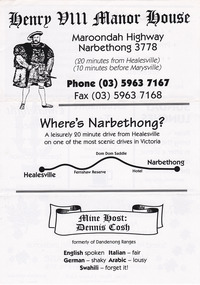
Flyer (Item) - Advertising flyer, Henry VIII Manor House, Unknown
... Henry VIII Manor House......henry viii manor house...An advertising flyer for the Henry VIII Manor House in Narbethong....An advertising flyer for the Henry VIII Manor House in Narbethong....Marysville & District Historical Society 39 Darwin Street Marysville yarra-valley-and-the-dandenong-ranges An advertising flyer for the Henry VIII Manor House in Narbethong. An advertising flyer for the Henry VIII Manor House in Narbethong. narbethong victoria australia henry viii manor house information flyer An advertising flyer for the Henry VIII Manor House in Narbethong. ...An advertising flyer for the Henry VIII Manor House in Narbethong.An advertising flyer for the Henry VIII Manor House in Narbethong.narbethong, victoria, australia, henry viii manor house, information flyer -
 Bacchus Marsh & District Historical Society
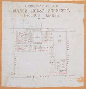
Map, Subdivision of the Manor House Property Bacchus Marsh c.1908
... Subdivision of the Manor House Property Bacchus Marsh c.1908......Manor House Bacchus Marsh...This included the large stone home known as the Manor House and various parcels of land including around 50 allotments of land near the Manor House, bounded by Young, Lerderderg, Crook and Main Streets. ...The map shows portions of land for sale from the subdivision of the Manor House property in Bacchus Marsh in 1908. ...This included the large stone home known as the Manor House and various parcels of land including around 50 allotments of land near the Manor House, bounded by Young, Lerderderg, Crook and Main Streets. ...This land sales plan shows allotments of land offered for sale in the inner township area of Bacchus Marsh in 1908. The land put up for sale was from the estate of the late Mr and Mrs J.E. Crook. That being James Elijah Crook and his wife Harriet, (nee Athorn). The Crooks had been resident in Bacchus Marsh since the 1840s and were prominent members of the community. They were prominent in the business, social and civic affairs of the town and district. In the 1850s the Crooks acquired the Manor House and nearby land once owned by the Bacchus family. James Crook died in 1889. When Harriet Crook died in February 1908 their estate was offered for sale. This included the large stone home known as the Manor House and various parcels of land including around 50 allotments of land near the Manor House, bounded by Young, Lerderderg, Crook and Main Streets. Most of these allotments of land were sold in October 1908. The Manor House itself was passed in at the sale and continued to be owned by the Crook family for several decades after 1908.A single page map on a single page of a bound volume of maps. The map shows portions of land for sale from the subdivision of the Manor House property in Bacchus Marsh in 1908. The names of most of the buyers of the portions of land have been hand-written into the various allotments they purchased. The maps are pasted into a bound volume containing 76 maps or plans in total. High resolution digital image stored on BMDHS computer network. bacchus marsh victoria maps, land sales bacchus marsh, manor house bacchus marsh, crook family bacchus marsh -
 National Wool Museum
Textile - Manor House Carpet Sample, Brintons Carpets, Geelong, c.1988
... Manor House Carpet Sample......Manor House Carpet...This carpet design sample is the first handmade test sample of the “Manor House” pattern carpet prepared for Geelong Wool Museum. ...Folder is blue with gold printed text. Textile Manor House Carpet Sample Brintons Carpets, Geelong ...This carpet design sample is the first handmade test sample of the “Manor House” pattern carpet prepared for Geelong Wool Museum. Carpet design sample and wool yarn colour samples in card presentation folder. Folder is blue with gold printed text. Front [printed]: Brintons carpets / woven for two centuries / COLOUR AND DESIGN / PRESENTATIONweaving, carpet, manor house carpet, national wool museum, design, loom, brintons, geelong -
 National Wool Museum
Textile - Manor House Rug Carpet Sample, National Wool Museum, 1990s
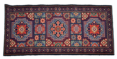
... Manor House Rug Carpet Sample...The Manor House Rug was designed by Brinton's Carpets in 1990 exclusively for the National Wool Museum. ...National Wool Museum 26 Moorabool Street Geelong geelong-and-the-bellarine-peninsula The Manor House Rug was designed by Brinton's Carpets in 1990 exclusively for the National Wool Museum. ...The Manor House Rug was designed by Brinton's Carpets in 1990 exclusively for the National Wool Museum. The design is based on an earlier design from Brinton's UK Persian Rug Archive Library. This Manor House Rug sample was woven at the National Wool Museum on the 1910 gripper type Axminster Jacquard carpet loom. The rug is made from 80% wool and 20% nylon, the internationally preferred blend for high quality, long lasting carpets.Red, green, blue, black, cream floral patterned carpet sample with jute backing.axminster loom, carpet, sample, rug, wool, national wool museum, brintons -
 Bacchus Marsh & District Historical Society
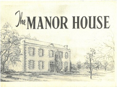
Pamphlet, The Manor House
... The Manor House......Manor House Bacchus Marsh...BMDHS Location: AR/SU5 Pamphlets Box 4. The Manor House Pamphlet ...This pamphlet outlines the early history of the house constructed for William Bacchus in 1846-1847 and briefly describes its condition as it was in 1957. William Bacchus was one of the first European colonists to live in the area in which a township (Bacchus Marsh) was later named after him. He arrived on land occupied by the Wurundjeri and Wadawurrung peoples in 1838 and established a large sheep farm. Between 1846 and 1847 he contracted builders and other skilled workers to construct a large brick and stone two storey house. William Bacchus died in 1849. His son Henry Bacchus sold the house in 1851. For many years it was owned by the Crook family. When this pamphlet was published in 1957 the house was owned by the Lifeguard Milk Company of Bacchus Marsh. By this time the property had become derelict and was almost demolished. Around this time the Young Mens Christian Association Club in Bacchus Marsh became involved in efforts to help preserve this historic property. This pamphlet was part of those efforts. PUBLICATION DETAILS: Y's Mens Club Bacchus Marsh, Bacchus Marsh, Vic., 1957. Text written by Ronald G. Westood.Small pamphlet. Stapled softcover. 23 unnumbered pages. 11cm x 16cm. Contains photographs and cover illustration. BMDHS Location: AR/SU5 Pamphlets Box 4.non-fictionThis pamphlet outlines the early history of the house constructed for William Bacchus in 1846-1847 and briefly describes its condition as it was in 1957. William Bacchus was one of the first European colonists to live in the area in which a township (Bacchus Marsh) was later named after him. He arrived on land occupied by the Wurundjeri and Wadawurrung peoples in 1838 and established a large sheep farm. Between 1846 and 1847 he contracted builders and other skilled workers to construct a large brick and stone two storey house. William Bacchus died in 1849. His son Henry Bacchus sold the house in 1851. For many years it was owned by the Crook family. When this pamphlet was published in 1957 the house was owned by the Lifeguard Milk Company of Bacchus Marsh. By this time the property had become derelict and was almost demolished. Around this time the Young Mens Christian Association Club in Bacchus Marsh became involved in efforts to help preserve this historic property. This pamphlet was part of those efforts. PUBLICATION DETAILS: Y's Mens Club Bacchus Marsh, Bacchus Marsh, Vic., 1957. Text written by Ronald G. Westood. william bacchus, bacchus family, henry bacchus, bacchus marsh, manor house bacchus marsh, houses bacchus marsh, historic buildings bacchus marsh -
 Eltham District Historical Society Inc
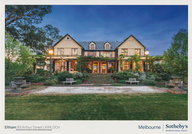
Document - Brochure, Sales Brocure: The Manor House at Kinloch Gardens, Eltham, 2017
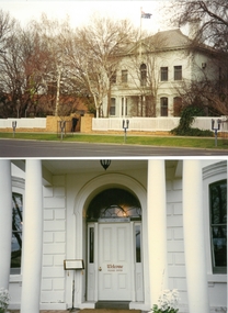
... Sales Brocure: The Manor House at Kinloch Gardens, Eltham....Colour photograph of the manor house known as Kinloch taken in the evening produced to promote the sale of the property produced by Sotheby's International Realty, Melbourne in 2017....Eltham District Historical Society Inc 728 Main Rd Eltham melbourne Colour photograph of the manor house known as Kinloch taken in the evening produced to promote the sale of the property produced by Sotheby's International Realty, Melbourne in 2017. arthur street, christine jelbart, eltham, houses, ian jelbart, jelbart property, kinloch gardens, kinloch manor, real estate advertisement, sotheby's international reality melbourne, woodridge estate Digital file only; created from scan undertaken by EDHS of item on loan Sales Brocure: The Manor House at Kinloch Gardens, Eltham. ...Colour photograph of the manor house known as Kinloch taken in the evening produced to promote the sale of the property produced by Sotheby's International Realty, Melbourne in 2017.Digital file only; created from scan undertaken by EDHS of item on loanarthur street, christine jelbart, eltham, houses, ian jelbart, jelbart property, kinloch gardens, kinloch manor, real estate advertisement, sotheby's international reality melbourne, woodridge estate -
![Book - Novel, Martin, Mrs A. H. (Mary Emma Martin), Roses from thorns : or the old manor house, [n.d.] [1880?]](/media/collectors/641920217f0478323d8a47a8/items/66790b85ea633ba0109bf7d9/item-media/67b6582c3824b0197b990617/item-fit-380x285.jpg?cb=6) Linton Mechanics Institute and Free Library Collection
Linton Mechanics Institute and Free Library CollectionBook - Novel, Martin, Mrs A. H. (Mary Emma Martin), Roses from thorns : or the old manor house, [n.d.] [1880?]
... Roses from thorns : or the old manor house...Roses from thorns : or the old manor house Book Novel Martin, Mrs A. H. (Mary Emma Martin) Cassell and Company ...152 p. : ill. Blue, red and gold cover, embossed in black - geometric design and leaves. fictionmary emma martin (mrs a. h. martin), children's fiction -
 Bacchus Marsh & District Historical Society
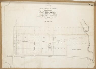
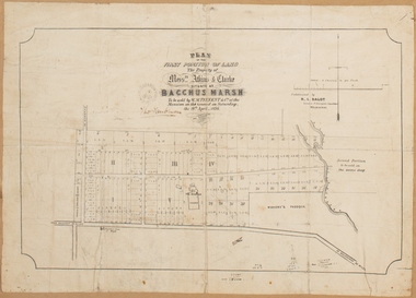
Map, Atkins and Clarke Land Sale situate at Bacchus Marsh 1856 Copy 2
... ...Manor House Bacchus Marsh...As the Crook family were the buyers of the Manor House property and surrounding land from Atkins and Clarke in 1856 it suggests that this copy is a later one of the earlier version. ...The subdivided land shown was owned by John Atkins and Robert Nalder Clarke, but previously owned by the Bacchus Family and was in and around their Manor House (Mansion) property in Bacchus Marsh.There are 5 portions of land further divided into numerous small portions. ...Land Sales Land Sales Bacchus Marsh Manor House Bacchus Marsh Crook Family Bacchus Marsh Plan of the first portion of land. ...This plan of land allotments for sale indicates the property once owned by the Bacchus family in and around the township area of Bacchus Marsh. The Bacchus family sold their property in Bacchus Marsh to John Atkins and Robert Nalder Clarke in March 1851. Atkins and Clarke kept the property for a number of years until April 1856 when these allotments were put up for sale.This plan is almost identical to another copy held by the Bacchus Marsh and District Historical Society, VC Record 707, BMDHS collection). This plan, VC Record 452 Copy 2, contains a less detail than than VC Record 707 Copy 1. For example the selling agents and the surveyor who created the plan are not indicated on this copy of the plan. This copy of the plan does indicate the name Crook Street on the map. As the Crook family were the buyers of the Manor House property and surrounding land from Atkins and Clarke in 1856 it suggests that this copy is a later one of the earlier version. It is unlikely that the Crook family would have had the adjacent street named after them prior to purchasing the house and property. This is a very early land sales plan for the township of Bacchus Marsh and it therefore provides some clues as to how the early urban development of the township took place. Upon seeing the map in 1911 Bacchus Marsh Express newspaper editor Christopher Crisp wrote "The sale appears to have created the present township, which had a nucleus in earlier times further east", Express, 30 September, 1911, page 3. A single page paper map showing a portions of land available for sale in Bacchus Marsh in 1856. The subdivided land shown was owned by John Atkins and Robert Nalder Clarke, but previously owned by the Bacchus Family and was in and around their Manor House (Mansion) property in Bacchus Marsh.There are 5 portions of land further divided into numerous small portions. The land for sale is bounded by the present day streets of Main Street, Young Street, McFarland Street, Morton Streets, Crook Street, and part of the eastern section extends to the Lerderderg River. Scale: 4 chains to 1 inch. The map is pasted into a bound volume containing 76 maps or plans in total. High resolution digital image stored on BMDHS computer network. Plan of the first portion of land. The property of Messers Atkins and Clarke situate at Bacchus Marsh.land sales, land sales bacchus marsh, manor house bacchus marsh, crook family bacchus marsh -
 Bacchus Marsh & District Historical Society
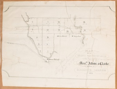
Map, Plan of the second portion of the property of Messers Atkins and Clarke situate at Bacchus Marsh 1856
... ...Manor House Bacchus Marsh...This plan shows allotments in the second portion of land to be sold which was located east of the Manor House on the eastern side of the Lerderderg River. ...Bacchus Marsh Victoria Maps Bacchus Family Land Sales Manor House Bacchus Marsh A single page paper plan showing allotments of land for sale. ...This plan of land allotments for sale indicates part of the property once owned by the Bacchus family in and around the township area of Bacchus Marsh. The Bacchus family sold their property in Bacchus Marsh to John Aitkins and Robert Nalder Clarke in March 1851. Aitkins and Clarke kept the property for a number of years until April 1856 when these allotments were put up for sale.This is a very early land sales plan for agricultural land close to the township of Bacchus Marsh. It therefore provides some clues as to how the early urban development of the township and agricultural development of the nearby area took place. Upon seeing the map in 1911 Bacchus Marsh Express newspaper editor Christopher Crisp wrote "The sale appears to have created the present township, which had a nucleus in earlier times further east", Express, 30 September, 1911, page 3.A single page paper plan showing allotments of land for sale. The subdivided land shown was owned by John Aitkins and Robert Nalder Clarke, but previously owned by the Bacchus Family and was in and around their Manor House (Mansion) property in Bacchus Marsh. This plan shows allotments in the second portion of land to be sold which was located east of the Manor House on the eastern side of the Lerderderg River. The land for sale was made up of 15 allotments. The plan is pasted into a bound volume containing 76 maps or plans in total. BMDHS Loc: AR/B12/S4 Bacchus Marsh Township and Nearby Districts Maps Volume In-house Digital copies: BMDHS, Computer Network: Maps\Bacchus Marsh Township and Nearby Districts Maps Volumebacchus marsh victoria maps, bacchus family, land sales, manor house bacchus marsh -
 National Wool Museum
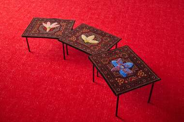
Textile - Orchid Tables, Dowel Jones, 2024
... ...Manor House Rug...The Manor House Rug features a central medallion with floral pattern. ...The Manor House Rug features a central medallion with floral pattern. ...The Orchid Tables were on display as part of the Ten Years of Dowel Jones exhibition at the National Wool Museum in 2024. The exhibition label reads: Sitting just outside this exhibition in the National Wool Museum is a 1910 Axminster Jacquard Carpet Loom. This loom was operating at Brintons factory in Geelong from 1960 to 1975, and then at the Melbourne College of Textiles, until it was donated to the museum. In the 1990's the museum commissioned an exclusive pattern called the Manor House Rug. Based on earlier designs from Brintons UK Persian Rug Archive Library, the museum continues to make this rug through the expertise of Loom Technician Michael Farquhar. The Manor House Rug features a central medallion with floral pattern. Working with illustrator Beci Orpin, and referencing Margaret MacDonald & Angair's book 'Orchids of the Anglesea District', we identified regional orchids. By a process of removal and addition, the original floral medallion was replaced with local species as decorative motif. Ten Year of Dowel Jones presents three altered Manor House Rugs, each with different orchids tufted in wool and placed in the centre of each rug. The rugs have been attached by cotton thread to three table frames at different heights to create the Orchid Tables.Three tables consisting of powder coated steel frames, with a woven carpet top. The table tops are made from wool with a jute backing, and feature a red, green, blue, black and cream floral design with an orchid in the centre. Each table is a different height.dowel jones, ten years of dowel jones, national wool museum, axminster loom, carpet, manor house rug, orchids, anglesea, design, art, furniture, beci orpin, brintons, geelong, melbourne college of textiles -
 Federation University Historical Collection
Booklet, F.C. Mc C. Crisp, Bacchus Marsh Centenary Celebrations, 10/1936
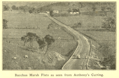
... ...manor house...Images include: * Bacchus Marsh Flats from Anthony's Cutting; * Manor house; * Scene in Maddingley Park * Werribee Valley; * Werribee Gorge * Maddingley Park lake; * ANA Hall and Post Office * Shire Hall and Soldiers' Memorial Hall, * State School No 28 * At Werribee Gorge ** The Gas Supply Co, Bacchus Marsh * Bacchus Marsh Shire Council, 1935-6 (named) Images depicted in the book were supplied by H.J.M. ...Lambert (Decorations manager) bacchus marsh merrimu guest house anthony's cutting captain bacchus manor house maddingley maddingley park werribee gorge bacchus marsh shire bacchus marsh shire council Brown covered book of 28 pages. ...Bacchus Marsh celebrated 100 years of white settlement in 1936. The centenary celebrations committee comprised of L.M. Dugdale (President), A.W. Bond (Hon. Secretary), Charles Dickie, W. Grant Morton, W.R. Vigor, C.J. McFarlane, G.H. Anderson, T.J. Shea, F.C. McC Crisp, Dr E. McDonald, Robert Elliott (treasurer), R.H. Lambert (Decorations manager)Brown covered book of 28 pages. The book includes an historical essay, official centenary programme, Electric Light Plant, Patriotic Bacchus Marsh, milk industry, Pioneer Women's Memorial Avenue, Bacchus Marsh Gas Works . The book includes numerous advertisement, some illustrated. Images include: * Bacchus Marsh Flats from Anthony's Cutting; * Manor house; * Scene in Maddingley Park * Werribee Valley; * Werribee Gorge * Maddingley Park lake; * ANA Hall and Post Office * Shire Hall and Soldiers' Memorial Hall, * State School No 28 * At Werribee Gorge ** The Gas Supply Co, Bacchus Marsh * Bacchus Marsh Shire Council, 1935-6 (named) Images depicted in the book were supplied by H.J.M. Vallancebacchus marsh, merrimu guest house, anthony's cutting, captain bacchus, manor house, maddingley, maddingley park, werribee gorge, bacchus marsh shire, bacchus marsh shire council -
 Bacchus Marsh & District Historical Society
Map, Plan of the property of Messers Atkins and Clarke to be sold at the Mansion, Bacchus Marsh 19th April 1856. Copy 1
... ...Manor House Bacchus Marsh...The subdivided land shown was owned by John Atkins and Robert Nalder Clarke, but previously owned by the Bacchus Family and was in and around their Manor House (Mansion) property in Bacchus Marsh.There are 5 portions of land further divided into numerous small portions. ...Bacchus Marsh Victoria Maps Bacchus Family Land Sales Manor House Bacchus Marsh Heading: Plan of the first portion of land. ...This plan of land allotments for sale indicates the property once owned by the Bacchus family in and around the township area of Bacchus Marsh. The Bacchus family sold their property in Bacchus Marsh to John Atkins and Robert Nalder Clarke in March 1851. Atkins and Clarke kept the property for a number of years until April 1856 when these allotments were put up for sale.This plan is almost identical to another copy held by the Bacchus Marsh and District Historical Society, VC Record 452, BMDHS collection). This plan, VC Record 707 Copy 1, contains a little more detail overall than VC Record 452 Copy 2, such as who did the survey work for the plan (R.C. Bagot) and who the selling agents were, (W.M. Tennent), and on the right side of the plan near the Lerderderg River is indicated the general area for a second parcel of land from this sale which is to be sold. There is also a compass illustration indicating north and south compass points.This is a very early land sales plan for the township of Bacchus Marsh and it therefore provides some clues as to how the early urban development of the township took place. Upon seeing the map in 1911 Bacchus Marsh Express newspaper editor Christopher Crisp wrote "The sale appears to have created the present township, which had a nucleus in earlier times further east", Express, 30 September, 1911, page 3.A single page paper plan showing allotments of land for sale. The subdivided land shown was owned by John Atkins and Robert Nalder Clarke, but previously owned by the Bacchus Family and was in and around their Manor House (Mansion) property in Bacchus Marsh.There are 5 portions of land further divided into numerous small portions. The land for sale is bounded by the present day streets of Main Street, Young Street, McFarland Street, Morton Streets, Crook Street, and part of the eastern section extends to the Lerderderg River. Scale: 8 chains to 1 inch The plan is pasted into a bound volume containing 76 maps or plans in total. BMDHS Loc: AR/B12/S4 Bacchus Marsh Township and Nearby Districts Maps Volume In-house Digital copies: BMDHS, Computer Network: Maps\Bacchus Marsh Township and Nearby Districts Maps VolumeHeading: Plan of the first portion of land. The property of Messers Atkins and Clarke situate at Bacchus Marsh. To be sold by W.M. Tennent & Co. at the Mansion on the Ground on Saturday the 19th April 1856. Below heading: Jas Ferguson, Lithographer On upper right side: Subdivided by R.C. Bagot London and Liverpool Chambers, Melbourne. 'Thos Taubman'. Post Office Stamp: BACCHUS MARSH VICTORIA MY 6, 63bacchus marsh victoria maps, bacchus family, land sales, manor house bacchus marsh -
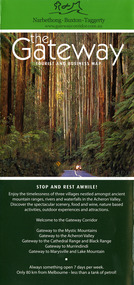
 Marysville & District Historical Society
Map (Item) - Tourist and business map, Narbethong Community and Tourism Group, Narbethong Buxton Taggerty Tourist and Business Map, 04-2008
... ...henry viii manor house...A tourist and business map of Narbethong, Buxton and Taggerty. narbethong buxton taggerty victoria australia tourist and business map narbethong community and tourism group acheron valley yarra track wood's point black spur mystic mountains the meeting of the waters cathedral range danico design counted cross stitch things of sand & stone buxton zoo nursery & oddz & enz willowbank at taggerty safe trek 4wd services pnl 4wdriving buxton trout and salmon farm mystic mountains ski hire & outdoors narbethong ski hire highwood health centre cathedral view natural therapies narby cabinets plants by shelian gb timber executive signs rb automotive repairs buxton car care marysville towing & equipment hire martyn slade building design cathedral peak framing black spur roadhouse & ski hire tudor lodge roadhouse & ski hire buxton roadhouse & persian bazzar buxton post office general store & niche bar igloo roadhouse taggerty store narby eggs marapana agistment park mantirri blueberry farm carmyle farm hazelwood hazelnuts south cathedral lavender farm cathedral cherries black spur motel & caravan park woodlands rainforest retreat chestnut glade black spur inn wombat cottage abbey lake luxury b & b spa cottages blue views holiday cottages camp narbethong marapana farm stay b & b mantirri blueberry farm b & b little dene garden cottages silverstream b & b cottages nareen cabins moondai farm b & b south cathedral farm luxury b & b cottages yarrolyn caravan park sarsens rest lomah retreat pinjarra gardens kingbilli country estate henry viii manor house buxton hotel butters cafe of buxton wagtail wines little river wines lanterns at willowbank wirrawilla rainforest walk wilhemina falls the cascades This publication has been produced by the Narbethong Community and Tourism/ Group (NCTG) to promote the natural attractions, adventure activities and food/ trail from the Black Spur, through Narbethong, Buxton and Taggerty./ the information provided in this publication has been supplied by the individual/ members. ...A tourist and business map of Narbethong, Buxton and Taggerty. This map was produced by the Narbethong Community and Tourism Group in April 2008. It was produced to promote the natural attractions, adventure activities and food trail from the Black Spur, through Narbethong, Buxton and Taggerty.A tourist and business map of Narbethong, Buxton and Taggerty.This publication has been produced by the Narbethong Community and Tourism/ Group (NCTG) to promote the natural attractions, adventure activities and food/ trail from the Black Spur, through Narbethong, Buxton and Taggerty./ the information provided in this publication has been supplied by the individual/ members. NCTG takes no responsibility for its accuracy./ April 2008narbethong, buxton, taggerty, victoria, australia, tourist and business map, narbethong community and tourism group, acheron valley, yarra track, wood's point, black spur, mystic mountains, the meeting of the waters, cathedral range, danico design counted cross stitch, things of sand & stone, buxton zoo nursery & oddz & enz, willowbank at taggerty, safe trek 4wd services, pnl 4wdriving, buxton trout and salmon farm, mystic mountains ski hire & outdoors, narbethong ski hire, highwood health centre, cathedral view natural therapies, narby cabinets, plants by shelian, gb timber, executive signs, rb automotive repairs, buxton car care, marysville towing & equipment hire, martyn slade building design, cathedral peak framing, black spur roadhouse & ski hire, tudor lodge roadhouse & ski hire, buxton roadhouse & persian bazzar, buxton post office general store & niche bar, igloo roadhouse, taggerty store, narby eggs, marapana agistment park, mantirri blueberry farm, carmyle farm, hazelwood hazelnuts, south cathedral lavender farm, cathedral cherries, black spur motel & caravan park, woodlands rainforest retreat, chestnut glade, black spur inn, wombat cottage, abbey lake luxury b & b spa cottages, blue views holiday cottages, camp narbethong, marapana farm stay b & b, mantirri blueberry farm b & b, little dene garden cottages, silverstream b & b cottages, nareen cabins, moondai farm b & b, south cathedral farm luxury b & b cottages, yarrolyn caravan park, sarsens rest, lomah retreat, pinjarra gardens, kingbilli country estate, henry viii manor house, buxton hotel, butters cafe of buxton, wagtail wines, little river wines, lanterns at willowbank, wirrawilla rainforest walk, wilhemina falls, the cascades -
 Marysville & District Historical Society
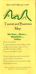
Map (Item) - Tourist and business map, Narbethong Community and Tourism Group, the Gateway TOURIST AND BUSINESS MAP, 08-2009
... ...henry v111 manor house...A tourist and business map of Narbethong, Buxton and Taggerty. narbethong buxton taggerty victoria australia tourist and business map the gateway tourist and business map black spur motel & caravan park woodlands rainforest retreat chestnut glade black spur inn wombat cottage abbey lake luxury b&b spa cottages camp narbethong marapana farm stay b&b mantirri b&b little dene garden cottages nareen cabins silverstream b&b cottages buxton hotel motel south cathedral farm luxury b&b cottages cathedral view b&b retreat kingbilli country estate cathedral valley farm pinjarra gardens willowbank at taggerty sarsens rest yarrolyn caravan park danico design counted cross stitch things of sand & stone buxton zoo nursery safetrek 4wd services mystic mountains ski hire & outdoors pnl 4wdriving buxton trout and salmon farm buxton bait and tackle black spur roadhouse tudor lodge service station roadhouse & ski hire buxton roadhouse buxton p.o. general store igloo roadhouse henry v111 manor house buxton hotel butters cafe wagtail wines little river wines narby eggs marapana agistment park carmyle farm hazelwood hazelnuts cathedral view naturall therapies cre8ing growth linda hailey naby cabinets gb timber narbethong timber & trading rb automotive repairs buxton car care martyn slade building design taggerty vet clinic This publication has been produced by the Narbethong Community and Tourism Group Inc./ (NCTG) The information provided in this publication has been supplied by the individual/ members. ...A tourist and business map of Narbethong, Buxton, and Taggerty. This map was produced by the Narbethong Community and Tourism Group Inc in August 2009. It was produced to promote the natural attractions, adventure activities, and food trail from the Black Spur, through Narbethong, Buxton, and Taggerty.A tourist and business map of Narbethong, Buxton and Taggerty.This publication has been produced by the Narbethong Community and Tourism Group Inc./ (NCTG) The information provided in this publication has been supplied by the individual/ members. NCTG takes no responsibility for its accuracy./ August 2009narbethong, buxton, taggerty, victoria, australia, tourist and business map, the gateway tourist and business map, black spur motel & caravan park, woodlands rainforest retreat, chestnut glade, black spur inn, wombat cottage, abbey lake luxury b&b spa cottages, camp narbethong, marapana farm stay b&b, mantirri b&b, little dene garden cottages, nareen cabins, silverstream b&b cottages, buxton hotel motel, south cathedral farm luxury b&b cottages, cathedral view b&b retreat, kingbilli country estate, cathedral valley farm, pinjarra gardens, willowbank at taggerty, sarsens rest, yarrolyn caravan park, danico design counted cross stitch, things of sand & stone, buxton zoo nursery, safetrek 4wd services, mystic mountains ski hire & outdoors, pnl 4wdriving, buxton trout and salmon farm, buxton bait and tackle, black spur roadhouse, tudor lodge service station roadhouse & ski hire, buxton roadhouse, buxton p.o. general store, igloo roadhouse, henry v111 manor house, buxton hotel, butters cafe, wagtail wines, little river wines, narby eggs, marapana agistment park, carmyle farm, hazelwood hazelnuts, cathedral view naturall therapies, cre8ing growth, linda hailey, naby cabinets, gb timber, narbethong timber & trading, rb automotive repairs, buxton car care, martyn slade building design, taggerty vet clinic -
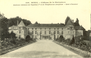 Federation University Historical Collection
Postcard - black and white, Rueil - Chateau de la Malmaison, c1918
... Black and white postcard of a three storey chateau. It was the manor house Joséphine de Beauharnais who bought the house in April 1799 for herself and her husband, General Napoléon Bonaparte, the future Napoléon I of France....(Wikipedia) chatham-holmes family collection rueil napoleon henry smerdon holmes Black and white postcard of a three storey chateau. It was the manor house Joséphine de Beauharnais who bought the house in April 1799 for herself and her husband, General Napoléon Bonaparte, the future Napoléon I of France. ...The Château de Malmaison is a country house in the city of Rueil-Malmaison about 12 km from Paris. It was formerly the residence of Joséphine de Beauharnais and, with the Tuileries, was from 1800 to 1802 the headquarters of the French government. (Wikipedia)Black and white postcard of a three storey chateau. It was the manor house Joséphine de Beauharnais who bought the house in April 1799 for herself and her husband, General Napoléon Bonaparte, the future Napoléon I of France.chatham-holmes family collection, rueil, napoleon, henry smerdon holmes -
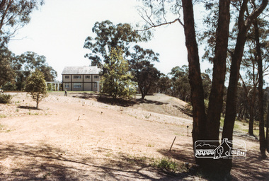 Eltham District Historical Society Inc
Photograph, The Jelbart Barn, 93 Arthur Street, Eltham, 1972c
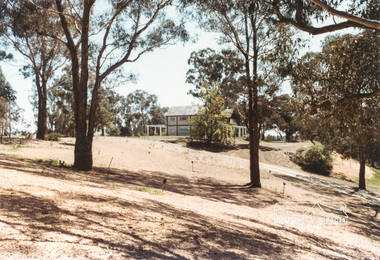
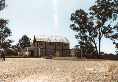
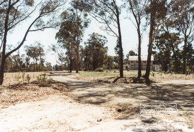
... This is a view of the Barn from the main manor house....This is a view of the Barn from the main manor house. arthur street, eltham, houses, jelbart barn, jelbart property, kinloch gardens Digital file only; created from scan undertaken by EDHS The Jelbart Barn, 93 Arthur Street, Eltham Photograph Photograph ...Owned at the time by architect, Ian Jelbart, the property had been in the Jelbart family since the 1940s; a 5560sqm secluded hilltop parcel in Eltham. When the manor house and its barn were built, Eltham was a rural community; Jelbart’s grandfather Ronald was a businessman whose poultry farm formed part of the family’s original 100ha holding. A portion would later be subdivided into residential lots to make way for new homes that would form the basis of the Woodridge Estate in the early 1970s. This is a view of the Barn from the main manor house.Digital file only; created from scan undertaken by EDHSarthur street, eltham, houses, jelbart barn, jelbart property, kinloch gardens -
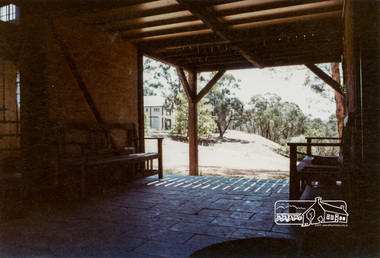 Eltham District Historical Society Inc
Photograph, The Jelbart Barn, 93 Arthur Street, Eltham, 1972c
... This is a view from The Barn looking towards the Manor House...This is a view from The Barn looking towards the Manor House arthur street, eltham, houses, jelbart barn, jelbart property, kinloch gardens verandah mud bricks enclosure Digital file only; created from scan undertaken by EDHS The Jelbart Barn, 93 Arthur Street, Eltham Photograph Photograph ...Owned at the time by architect, Ian Jelbart, the property had been in the Jelbart family since the 1940s; a 5560sqm secluded hilltop parcel in Eltham. When the manor house and its barn were built, Eltham was a rural community; Jelbart’s grandfather Ronald was a businessman whose poultry farm formed part of the family’s original 100ha holding. A portion would later be subdivided into residential lots to make way for new homes that would form the basis of the Woodridge Estate in the early 1970s. The Barn was developed as a residence by Ian Jelbart in the late 1960;'s. Handmade mud bricks were used in its construction. This is a view from The Barn looking towards the Manor HouseDigital file only; created from scan undertaken by EDHSarthur street, eltham, houses, jelbart barn, jelbart property, kinloch gardens, verandah, mud bricks, enclosure -
 Eltham District Historical Society Inc
Photograph, The Jelbart Barn, 93 Arthur Street, Eltham, 1972c
... Owned at the time by architect, Ian Jelbart, the property had been in the Jelbart family since the 1940s; a 5560sqm secluded hilltop parcel in Eltham. When the manor house and its barn were built, Eltham was a rural community; Jelbart’s grandfather Ronald was a businessman whose poultry farm formed part of the family’s original 100ha holding. ...Eltham District Historical Society Inc 728 Main Rd Eltham melbourne Owned at the time by architect, Ian Jelbart, the property had been in the Jelbart family since the 1940s; a 5560sqm secluded hilltop parcel in Eltham. When the manor house and its barn were built, Eltham was a rural community; Jelbart’s grandfather Ronald was a businessman whose poultry farm formed part of the family’s original 100ha holding. ...Owned at the time by architect, Ian Jelbart, the property had been in the Jelbart family since the 1940s; a 5560sqm secluded hilltop parcel in Eltham. When the manor house and its barn were built, Eltham was a rural community; Jelbart’s grandfather Ronald was a businessman whose poultry farm formed part of the family’s original 100ha holding. A portion would later be subdivided into residential lots to make way for new homes that would form the basis of the Woodridge Estate in the early 1970s.Digital file only; created from scan undertaken by EDHSarthur street, eltham, houses, jelbart barn, jelbart property, kinloch gardens -
 Bendigo Historical Society Inc.
Photograph - Tui Mitchell Collection: "Greystanes" Photographs, 1990s
... The photographs are a record of the restoration of "Greystanes Manor" house including a restaurant, accommodation and reception rooms. ...The photographs are a record of the restoration of "Greystanes Manor" house including a restaurant, accommodation and reception rooms. ..."Greystanes" was originally "Hunter House" built at 57 Queen Street, Bendigo by Robert Hunter in 1882. Robert's brother William and his family lived there for almost 60 years. In 1945 the house was sold to Rex Hyett who renamed the house "Greystanes". Rex removed the original verandah and balcony and built the portico. There were several other owners before it was purchased by the Country Roads Board/ VicRoads where it was the local office for 36 years years (1958 - 1994). From the late 1990s "Greystanes" was restored by Bill and Tui Mitchell who operated it as accommodation, restaurant and reception rooms. New owners then turned it into a boutique hotel and conference centre. The current owners purchased "Greystanes" in 1910. It was renamed "Hunter House" and after extensive restorations was converted into a family home and business .Photographs removed from album with adhesive pages (10895.10). Blue two ringed folder. The photographs are a record of the restoration of "Greystanes Manor" house including a restaurant, accommodation and reception rooms. It includes photographs of guest rooms, living rooms, kitchen areas, storage areas, fittings and furnishings, external areas, restoration works, bathrooms, gardens and staff members. There are 190 photographs The album also includes two letters of appreciation from guests who stayed at "Greystanes" and a two-page wine list from the restaurant. The wine list includes wines from several local wineries.tui mitchell collection, greystanes, hunter house, william hunter, robert hunter, tui mitchell, bill mitchell -
 Bendigo Historical Society Inc.
Album - Tui Mitchell Collection: "Greystanes" Photograph Album, 1990s
... The photographs are a record of the restoration of "Greystanes Manor" house including a restaurant, accommodation and reception rooms. ...The photographs are a record of the restoration of "Greystanes Manor" house including a restaurant, accommodation and reception rooms. ..."Greystanes" was originally "Hunter House" built at 57 Queen Street, Bendigo by Robert Hunter in 1882. Robert's brother William and his family lived there for almost 60 years. In 1945 the house was sold to Rex Hyett who renamed the house "Greystanes". Rex removed the original verandah and balcony and built the portico. There were several other owners before it was purchased by the Country Roads Board/ VicRoads where it was the local office for 36 years years (1958 - 1994). From the late 1990s "Greystanes" was restored by Bill and Tui Mitchell who operated it as accommodation, restaurant and reception rooms. New owners then turned it into a boutique hotel and conference centre. The current owners purchased "Greystanes" in 1910. It was renamed "Hunter House" and after extensive restorations was converted into a family home and business .Red leather covered three ring photograph album with fifty adhesive pages containing eighty nine coloured photographs, two letters and a two page printed wine list. Front of album has three gold coloured lines as a border and the spine has five horizontal sets of three gold coloured lines. The photographs are a record of the restoration of "Greystanes Manor" house including a restaurant, accommodation and reception rooms. It includes photographs of guest rooms, living rooms, kitchen areas, storage areas, fittings and furnishings, external areas, restoration works, bathrooms, gardens and staff members. The album also includes two letters of appreciation from guests who stayed at "Greystanes" and a two page wine list from the restaurant. The wine list includes wines from several local wineries.tui mitchell collection, greystanes, hunter house, william hunter, robert hunter, tui mitchell, bill mitchell -
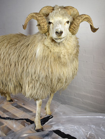 National Wool Museum
Taxidermy Sheep, Bilby Bill, c1980
... The yarn used on the National Wool Museum’s Axminster Gripper Loom to make the Manor House Rug is spun from the wool of Drysdale sheep....The yarn used on the National Wool Museum’s Axminster Gripper Loom to make the Manor House Rug is spun from the wool of Drysdale sheep. drysdale sheep new zealand Taxidermied male Drysdale sheep. ...Originating in New Zealand, the Drysdale, represented by Bilby Bill, was developed in the 1930s at Massey University (Canterbury) by crossing a coarse haired Romney and the hardy Cheviot breed. First imported to Australia in 1975, the Drysdale, due to a genetic abnormality, produces coarse, long staple fleece. This same gene also gives them their horns, something that generally does not occur in the parent breeds. Their fleece grows very fast, up to 25cm every six months; as such shearing is carried out twice a year. The coarse and hard wearing wool is mostly used for the manufacture of carpets. The Drysdale is a medium to large stocky sheep, weighing approximately 55kg and produces about 6 to 8kg of fleece per animal annually, which is 35 to 45 microns in diameter. The yarn used on the National Wool Museum’s Axminster Gripper Loom to make the Manor House Rug is spun from the wool of Drysdale sheep.Taxidermied male Drysdale sheep. Medium sized animal with white body coloration. Large horns protruding from the top of the skull. drysdale, sheep, new zealand -
 Glen Eira Historical Society
Article - LANGDON FAMILY
... Ballantyne. 8/Photocopy of extracts from ‘Langdon Court – the History of an English Manor House’ dated 1983/1984....Ballantyne. 8/Photocopy of extracts from ‘Langdon Court – the History of an English Manor House’ dated 1983/1984. Campbell Ewan Langdon Mary Campbell Mary Campbell J. ...This file contains 8 items about members of the Langdon family including a family tree: 1/Photocopies of a photograph of the wedding of Mary Langdon and Ewan Campbell on 26/11/1903. 2/Photocopy of an article, source and date unknown, describing the wedding of Mary Langdon and Ewan Campbell. 3/Photocopy of newspaper wedding notice, date and source unknown, announcing the wedding of Dorothy Langdon and J. H. C. Campbell on 11/06/1913. 4/Handwritten and drawn family tree of the Langdon family tree from Henry and Elizabeth Langdon and three generations subsequent. Author and date unknown. 5/Photograph of Order of Service for dedication of a memorial window at St Mary’s Anglican Church, Caulfield to Mr. and Mrs. H. J. Langdon on 28/09/1913. 6/Colour photograph of Marie Langdon and Margaret Moxham with the statue of Isabella Webb, Half-sister of Mrs. D. Langdon. 7/Photocopy of photograph of Grace Peterkin, formerly Langdon, and two boys, Stuart and Lang. Date unknown, photographer R. Ballantyne. 8/Photocopy of extracts from ‘Langdon Court – the History of an English Manor House’ dated 1983/1984.campbell ewan, langdon mary, campbell mary, campbell j. h. c., langdon dorothy, campbell dorothy, ‘rosecraddock’, langley h. t. rev., st mary’s anglican church caulfield, langdon henry joseph, langdon elizabeth laetitia lane, caulfield city hall, webb isabella, langdon d. mrs., langdon marie, moxham margaret, peterkin grace, langdon grace, garnett ian maxwell, langdon vernon, statues, somers charles -
 Eltham District Historical Society Inc
Photograph, Eltham Fire Station, Main Road, Eltham Heritage Tour, 24 May 1992, 24/05/1992
... Massed among the wattles and eucalypts were golden cypress and pines; No. 50 was an exotic 'old English' manor-house; No. 93 had bluestone gateposts, from Fenton Road Toorak (as with Montsalvat, using re-cycled building material was very much the trend); past the natural Reserve dedicated to the artist Walter Withers, a plaque on a huge boulder; and on both sides houses in the various modes - timber with wrought iron decor, brick-some more recent than others, decades of 'suburbia'."...Massed among the wattles and eucalypts were golden cypress and pines; No. 50 was an exotic 'old English' manor-house; No. 93 had bluestone gateposts, from Fenton Road Toorak (as with Montsalvat, using re-cycled building material was very much the trend); past the natural Reserve dedicated to the artist Walter Withers, a plaque on a huge boulder; and on both sides houses in the various modes - timber with wrought iron decor, brick-some more recent than others, decades of 'suburbia'." ...ELTHAM HERITAGE TOUR The Society excursion on 24th May 1992 was arranged by David Bick, leader of the team carrying out the Shire's heritage study. David selected a number of sites or buildings identified in the study, some of them lesser known components of the Shire's heritage. The tour commenced at the Eltham Shire Office at 10.00 am. Travel was by private car and mini-bus with stops at about twelve locations for commentary by David.It included a short walk in Hurstbridge and lunch at Kinglake. Highlights of the tour included: - 10 am Leave from Shire Offices - 3 Important Trees - A Physical Link to Eltham's First Settlers - Toorak Mansion Gates - A Surviving Farm House - An Intact Circa 1900 Main Street - First Settlers - Gold Miners, and Timber-getters - An Early Hotel - A Pioneering Homestead - Changing Eltham Shire - 20th Century - 4 pm Afternoon Tea and Finish Tour Extract from ELTHAM CULTURAL HERITAGE TOUR (Newsletter No. 85, July 1992, by Bettina Woodburn) "Commencing with a quick walk to see the magnificent bell at the Eltham Fire Station, we then 'drove along Arthur Street. Here were examples of what constitutes the building environment of Eltham. Massed among the wattles and eucalypts were golden cypress and pines; No. 50 was an exotic 'old English' manor-house; No. 93 had bluestone gateposts, from Fenton Road Toorak (as with Montsalvat, using re-cycled building material was very much the trend); past the natural Reserve dedicated to the artist Walter Withers, a plaque on a huge boulder; and on both sides houses in the various modes - timber with wrought iron decor, brick-some more recent than others, decades of 'suburbia'."Record of the Society's history and activities and highlighting various aspects of the Heritage Study undertaken by David Bick used to create the future heritage overlay for the Shire of Eltham and later Nillumbik Shire.Roll of 35mm colour negative film, 4 stripsKodak Gold 100 5095eltham, main road, shire of eltham historical society, activities, heritage tour, cfa