Showing 7 items matching "manor house bacchus marsh"
-
 Bacchus Marsh & District Historical Society
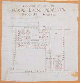
Map, Subdivision of the Manor House Property Bacchus Marsh c.1908
... Subdivision of the Manor House Property Bacchus Marsh c.1908......Manor House Bacchus Marsh...Bacchus Marsh in 1908. The land put up for sale was from the estate of the late Mr and Mrs J.E. Crook. That being James Elijah Crook and his wife Harriet, (nee Athorn). The Crooks had been resident in Bacchus Marsh since the 1840s and were prominent members of the community. They were prominent in the business, social and civic affairs of the town and district. In the 1850s the Crooks acquired the Manor House...The map shows portions of land for sale from the subdivision of the Manor House property in Bacchus Marsh in 1908. The names of most of the buyers of the portions of land have been hand-written into the various allotments they purchased. ... Victoria Maps Land Sales Bacchus Marsh Manor House Bacchus Marsh Crook Family Bacchus Marsh A single page map on a single page of a bound volume of maps. ...This land sales plan shows allotments of land offered for sale in the inner township area of Bacchus Marsh in 1908. The land put up for sale was from the estate of the late Mr and Mrs J.E. Crook. That being James Elijah Crook and his wife Harriet, (nee Athorn). The Crooks had been resident in Bacchus Marsh since the 1840s and were prominent members of the community. They were prominent in the business, social and civic affairs of the town and district. In the 1850s the Crooks acquired the Manor House and nearby land once owned by the Bacchus family. James Crook died in 1889. When Harriet Crook died in February 1908 their estate was offered for sale. This included the large stone home known as the Manor House and various parcels of land including around 50 allotments of land near the Manor House, bounded by Young, Lerderderg, Crook and Main Streets. Most of these allotments of land were sold in October 1908. The Manor House itself was passed in at the sale and continued to be owned by the Crook family for several decades after 1908.A single page map on a single page of a bound volume of maps. The map shows portions of land for sale from the subdivision of the Manor House property in Bacchus Marsh in 1908. The names of most of the buyers of the portions of land have been hand-written into the various allotments they purchased. The maps are pasted into a bound volume containing 76 maps or plans in total. High resolution digital image stored on BMDHS computer network. bacchus marsh victoria maps, land sales bacchus marsh, manor house bacchus marsh, crook family bacchus marsh -
 Bacchus Marsh & District Historical Society
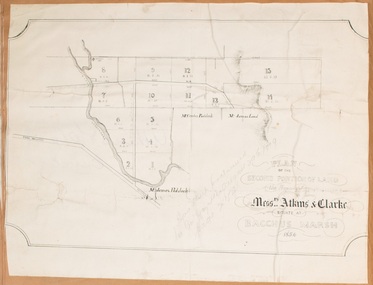
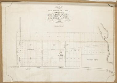
Map, Plan of the second portion of the property of Messers Atkins and Clarke situate at Bacchus Marsh 1856
... ...Manor House Bacchus Marsh...The subdivided land shown was owned by John Aitkins and Robert Nalder Clarke, but previously owned by the Bacchus Family and was in and around their Manor House (Mansion) property in Bacchus Marsh. ...Marsh A single page paper plan showing allotments of land for sale. The subdivided land shown was owned by John Aitkins and Robert Nalder Clarke, but previously owned by the Bacchus Family and was in and around their Manor House (Mansion) property in Bacchus Marsh. ...This plan of land allotments for sale indicates part of the property once owned by the Bacchus family in and around the township area of Bacchus Marsh. The Bacchus family sold their property in Bacchus Marsh to John Aitkins and Robert Nalder Clarke in March 1851. Aitkins and Clarke kept the property for a number of years until April 1856 when these allotments were put up for sale.This is a very early land sales plan for agricultural land close to the township of Bacchus Marsh. It therefore provides some clues as to how the early urban development of the township and agricultural development of the nearby area took place. Upon seeing the map in 1911 Bacchus Marsh Express newspaper editor Christopher Crisp wrote "The sale appears to have created the present township, which had a nucleus in earlier times further east", Express, 30 September, 1911, page 3.A single page paper plan showing allotments of land for sale. The subdivided land shown was owned by John Aitkins and Robert Nalder Clarke, but previously owned by the Bacchus Family and was in and around their Manor House (Mansion) property in Bacchus Marsh. This plan shows allotments in the second portion of land to be sold which was located east of the Manor House on the eastern side of the Lerderderg River. The land for sale was made up of 15 allotments. The plan is pasted into a bound volume containing 76 maps or plans in total. BMDHS Loc: AR/B12/S4 Bacchus Marsh Township and Nearby Districts Maps Volume In-house Digital copies: BMDHS, Computer Network: Maps\Bacchus Marsh Township and Nearby Districts Maps Volumebacchus marsh victoria maps, bacchus family, land sales, manor house bacchus marsh -
 Bacchus Marsh & District Historical Society
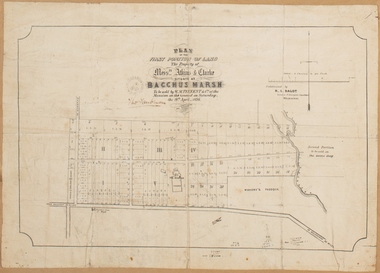
Map, Plan of the property of Messers Atkins and Clarke to be sold at the Mansion, Bacchus Marsh 19th April 1856. Copy 1
... ...Manor House Bacchus Marsh...Bacchus Family and was in and around their Manor House (Mansion) property in Bacchus Marsh.There are 5 portions of land further divided into numerous small portions. The land for sale is bounded by the present day streets of Main Street, Young Street, McFarland Street, Morton Streets, Crook Street, and part of the eastern section extends to the Lerderderg River. Scale: 8 chains to 1 inch The plan is pasted into a bound volume containing 76 maps or plans in total. BMDHS Loc: AR/B12/S4 Bacchus Marsh...Bacchus Marsh and it therefore provides some clues as to how the early urban development of the township took place. Upon seeing the map in 1911 Bacchus Marsh Express newspaper editor Christopher Crisp wrote "The sale appears to have created the present township, which had a nucleus in earlier times further east", Express, 30 September, 1911, page 3. Bacchus Marsh Victoria Maps Bacchus Family Land Sales Manor House ...This plan of land allotments for sale indicates the property once owned by the Bacchus family in and around the township area of Bacchus Marsh. The Bacchus family sold their property in Bacchus Marsh to John Atkins and Robert Nalder Clarke in March 1851. Atkins and Clarke kept the property for a number of years until April 1856 when these allotments were put up for sale.This plan is almost identical to another copy held by the Bacchus Marsh and District Historical Society, VC Record 452, BMDHS collection). This plan, VC Record 707 Copy 1, contains a little more detail overall than VC Record 452 Copy 2, such as who did the survey work for the plan (R.C. Bagot) and who the selling agents were, (W.M. Tennent), and on the right side of the plan near the Lerderderg River is indicated the general area for a second parcel of land from this sale which is to be sold. There is also a compass illustration indicating north and south compass points.This is a very early land sales plan for the township of Bacchus Marsh and it therefore provides some clues as to how the early urban development of the township took place. Upon seeing the map in 1911 Bacchus Marsh Express newspaper editor Christopher Crisp wrote "The sale appears to have created the present township, which had a nucleus in earlier times further east", Express, 30 September, 1911, page 3.A single page paper plan showing allotments of land for sale. The subdivided land shown was owned by John Atkins and Robert Nalder Clarke, but previously owned by the Bacchus Family and was in and around their Manor House (Mansion) property in Bacchus Marsh.There are 5 portions of land further divided into numerous small portions. The land for sale is bounded by the present day streets of Main Street, Young Street, McFarland Street, Morton Streets, Crook Street, and part of the eastern section extends to the Lerderderg River. Scale: 8 chains to 1 inch The plan is pasted into a bound volume containing 76 maps or plans in total. BMDHS Loc: AR/B12/S4 Bacchus Marsh Township and Nearby Districts Maps Volume In-house Digital copies: BMDHS, Computer Network: Maps\Bacchus Marsh Township and Nearby Districts Maps VolumeHeading: Plan of the first portion of land. The property of Messers Atkins and Clarke situate at Bacchus Marsh. To be sold by W.M. Tennent & Co. at the Mansion on the Ground on Saturday the 19th April 1856. Below heading: Jas Ferguson, Lithographer On upper right side: Subdivided by R.C. Bagot London and Liverpool Chambers, Melbourne. 'Thos Taubman'. Post Office Stamp: BACCHUS MARSH VICTORIA MY 6, 63bacchus marsh victoria maps, bacchus family, land sales, manor house bacchus marsh -
 Bacchus Marsh & District Historical Society
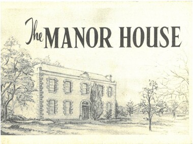
Pamphlet, The Manor House
... ...Manor House Bacchus Marsh...Bacchus Marsh & District Historical Society Lerderderg Library Main Street Bacchus Marsh William Bacchus Bacchus Family Henry Bacchus Bacchus Marsh Manor House Bacchus Marsh Houses Bacchus Marsh Historic buildings Bacchus Marsh This pamphlet outlines the early history of the house constructed for William Bacchus in 1846-1847 and briefly describes its condition as it was in 1957. ...This pamphlet outlines the early history of the house constructed for William Bacchus in 1846-1847 and briefly describes its condition as it was in 1957. William Bacchus was one of the first European colonists to live in the area in which a township (Bacchus Marsh) was later named after him. He arrived on land occupied by the Wurundjeri and Wadawurrung peoples in 1838 and established a large sheep farm. Between 1846 and 1847 he contracted builders and other skilled workers to construct a large brick and stone two storey house. William Bacchus died in 1849. His son Henry Bacchus sold the house in 1851. For many years it was owned by the Crook family. When this pamphlet was published in 1957 the house was owned by the Lifeguard Milk Company of Bacchus Marsh. By this time the property had become derelict and was almost demolished. Around this time the Young Mens Christian Association Club in Bacchus Marsh became involved in efforts to help preserve this historic property. This pamphlet was part of those efforts. PUBLICATION DETAILS: Y's Mens Club Bacchus Marsh, Bacchus Marsh, Vic., 1957. Text written by Ronald G. Westood.Small pamphlet. Stapled softcover. 23 unnumbered pages. 11cm x 16cm. Contains photographs and cover illustration. BMDHS Location: AR/SU5 Pamphlets Box 4.non-fictionThis pamphlet outlines the early history of the house constructed for William Bacchus in 1846-1847 and briefly describes its condition as it was in 1957. William Bacchus was one of the first European colonists to live in the area in which a township (Bacchus Marsh) was later named after him. He arrived on land occupied by the Wurundjeri and Wadawurrung peoples in 1838 and established a large sheep farm. Between 1846 and 1847 he contracted builders and other skilled workers to construct a large brick and stone two storey house. William Bacchus died in 1849. His son Henry Bacchus sold the house in 1851. For many years it was owned by the Crook family. When this pamphlet was published in 1957 the house was owned by the Lifeguard Milk Company of Bacchus Marsh. By this time the property had become derelict and was almost demolished. Around this time the Young Mens Christian Association Club in Bacchus Marsh became involved in efforts to help preserve this historic property. This pamphlet was part of those efforts. PUBLICATION DETAILS: Y's Mens Club Bacchus Marsh, Bacchus Marsh, Vic., 1957. Text written by Ronald G. Westood. william bacchus, bacchus family, henry bacchus, bacchus marsh, manor house bacchus marsh, houses bacchus marsh, historic buildings bacchus marsh -
 Bacchus Marsh & District Historical Society
Map, Atkins and Clarke Land Sale situate at Bacchus Marsh 1856 Copy 2
... ...Manor House Bacchus Marsh...Bacchus Marsh and District Historical Society, VC Record 707, BMDHS collection). This plan, VC Record 452 Copy 2, contains a less detail than than VC Record 707 Copy 1. For example the selling agents and the surveyor who created the plan are not indicated on this copy of the plan. This copy of the plan does indicate the name Crook Street on the map. As the Crook family were the buyers of the Manor House...Bacchus Marsh in 1856. The subdivided land shown was owned by John Atkins and Robert Nalder Clarke, but previously owned by the Bacchus Family and was in and around their Manor House (Mansion) property in Bacchus Marsh.There are 5 portions of land further divided into numerous small portions. ...house and property. This is a very early land sales plan for the township of Bacchus Marsh and it therefore provides some clues as to how the early urban development of the township took place. Upon seeing the map in 1911 Bacchus Marsh Express newspaper editor Christopher Crisp wrote "The sale appears to have created the present township, which had a nucleus in earlier times further east", Express, 30 September, 1911, page 3. Land Sales Land Sales Bacchus Marsh Manor ...This plan of land allotments for sale indicates the property once owned by the Bacchus family in and around the township area of Bacchus Marsh. The Bacchus family sold their property in Bacchus Marsh to John Atkins and Robert Nalder Clarke in March 1851. Atkins and Clarke kept the property for a number of years until April 1856 when these allotments were put up for sale.This plan is almost identical to another copy held by the Bacchus Marsh and District Historical Society, VC Record 707, BMDHS collection). This plan, VC Record 452 Copy 2, contains a less detail than than VC Record 707 Copy 1. For example the selling agents and the surveyor who created the plan are not indicated on this copy of the plan. This copy of the plan does indicate the name Crook Street on the map. As the Crook family were the buyers of the Manor House property and surrounding land from Atkins and Clarke in 1856 it suggests that this copy is a later one of the earlier version. It is unlikely that the Crook family would have had the adjacent street named after them prior to purchasing the house and property. This is a very early land sales plan for the township of Bacchus Marsh and it therefore provides some clues as to how the early urban development of the township took place. Upon seeing the map in 1911 Bacchus Marsh Express newspaper editor Christopher Crisp wrote "The sale appears to have created the present township, which had a nucleus in earlier times further east", Express, 30 September, 1911, page 3. A single page paper map showing a portions of land available for sale in Bacchus Marsh in 1856. The subdivided land shown was owned by John Atkins and Robert Nalder Clarke, but previously owned by the Bacchus Family and was in and around their Manor House (Mansion) property in Bacchus Marsh.There are 5 portions of land further divided into numerous small portions. The land for sale is bounded by the present day streets of Main Street, Young Street, McFarland Street, Morton Streets, Crook Street, and part of the eastern section extends to the Lerderderg River. Scale: 4 chains to 1 inch. The map is pasted into a bound volume containing 76 maps or plans in total. High resolution digital image stored on BMDHS computer network. Plan of the first portion of land. The property of Messers Atkins and Clarke situate at Bacchus Marsh.land sales, land sales bacchus marsh, manor house bacchus marsh, crook family bacchus marsh -
 Federation University Historical Collection
Booklet, F.C. Mc C. Crisp, Bacchus Marsh Centenary Celebrations, 10/1936
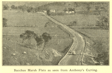
... Bacchus Marsh, milk industry, Pioneer Women's Memorial Avenue, Bacchus Marsh Gas Works . The book includes numerous advertisement, some illustrated. Images include: * Bacchus Marsh Flats from Anthony's Cutting; * Manor house; * Scene in Maddingley Park * Werribee Valley; * Werribee Gorge * Maddingley Park lake; * ANA Hall and Post Office * Shire Hall and Soldiers' Memorial Hall, * State School No 28 * At Werribee Gorge ** The Gas Supply Co, Bacchus Marsh * Bacchus Marsh Shire Council, 1935-6 (named) Images depicted in the book were supplied by H.J.M. ...house maddingley maddingley park werribee gorge bacchus marsh shire bacchus marsh shire council Brown covered book of 28 pages. The book includes an historical essay, official centenary programme, Electric Light Plant, Patriotic Bacchus Marsh, milk industry, Pioneer Women's Memorial Avenue, Bacchus Marsh Gas Works . The book includes numerous advertisement, some illustrated. Images include: * Bacchus Marsh Flats from Anthony's Cutting; * Manor ...Bacchus Marsh celebrated 100 years of white settlement in 1936. The centenary celebrations committee comprised of L.M. Dugdale (President), A.W. Bond (Hon. Secretary), Charles Dickie, W. Grant Morton, W.R. Vigor, C.J. McFarlane, G.H. Anderson, T.J. Shea, F.C. McC Crisp, Dr E. McDonald, Robert Elliott (treasurer), R.H. Lambert (Decorations manager)Brown covered book of 28 pages. The book includes an historical essay, official centenary programme, Electric Light Plant, Patriotic Bacchus Marsh, milk industry, Pioneer Women's Memorial Avenue, Bacchus Marsh Gas Works . The book includes numerous advertisement, some illustrated. Images include: * Bacchus Marsh Flats from Anthony's Cutting; * Manor house; * Scene in Maddingley Park * Werribee Valley; * Werribee Gorge * Maddingley Park lake; * ANA Hall and Post Office * Shire Hall and Soldiers' Memorial Hall, * State School No 28 * At Werribee Gorge ** The Gas Supply Co, Bacchus Marsh * Bacchus Marsh Shire Council, 1935-6 (named) Images depicted in the book were supplied by H.J.M. Vallancebacchus marsh, merrimu guest house, anthony's cutting, captain bacchus, manor house, maddingley, maddingley park, werribee gorge, bacchus marsh shire, bacchus marsh shire council -
 Bacchus Marsh & District Historical Society
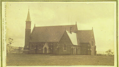
Photograph - Saint Bernard's Roman Catholic Church, Lerderderg Street Bacchus Marsh 1883
... Housed in the Jeremeas Family Album which contains photographs of Bacchus Marsh and District in 1883 by the photographers Stevenson and McNicoll. The image shows Saint Bernard's Catholic Church in Bacchus Marsh nine years after it was erected in 1874. The view of the Church is looking north from somewhere around the present day location of Manor...Housed in the Jeremeas Family Album which contains photographs of Bacchus Marsh and District in 1883 by the photographers Stevenson and McNicoll. The image shows Saint Bernard's Catholic Church in Bacchus Marsh nine years after it was erected in 1874. The view of the Church is looking north from somewhere around the present day location of Manor ...This Catholic Church was built between 1872 and 1874. It was the first permanent Catholic Church building in Bacchus Marsh. Catholics had lived in the Bacchus Marsh area since the early 1840s and in this early period religious services had been conducted in a number of different buildings including peoples' homes. This Church still stands and continues to be the main place of worship for Catholics in the Bacchus Marsh area. Small sepia 'carte de viste' style unframed photograph on card with gold border framing photograph. Housed in the Jeremeas Family Album which contains photographs of Bacchus Marsh and District in 1883 by the photographers Stevenson and McNicoll. The image shows Saint Bernard's Catholic Church in Bacchus Marsh nine years after it was erected in 1874. The view of the Church is looking north from somewhere around the present day location of Manor Street Bacchus Marsh. This image was taken before the Presbytery was built in 1889.Printed On the front: Stevenson & McNicoll. Photo. 108 Elizabeth St. Melbourne. COPIES CAN BE OBTAINED AT ANY TIME. On the back: LIGHT & TRUTH inscribed on a banner surmounted by a representation of the rising sun. Copies of this Portrait can be had at any time by sending the Name and Post Office Money Order or Stamps for the amount of order to STEVENSON & McNICOLL LATE BENSON & STEVENSON, Photographers. 108 Elizabeth Street, MELBOURNE. stevenson and mcnicoll 1883 photographs of bacchus marsh and district, churches bacchus marsh, catholic church bacchus marsh, saint bernards roman catholic church bacchus marsh