Federation University Historical Collection
Map, Robert Brough Smyth, Sketch Map of the Colony of Victoria, c1871, c1872
... Barker Library (top floor) Mount Helen goldfields victoria victorian counties robert brough-smyth telegraph population bourke rodney dalhousie evelyn mornington buln-buln tanjil dargo delatite moira bogong bendigo gunbower grant talbot hampden heytesbury polwarth ripon kara-kara gladstone grenville croajingolong tambo benambra This map includes the population of each County in Victoria according to the 1871 Census, as well as the population of each Australian colony and New Zealand.
...
This map includes the population of each County in Victoria according to the 1871 Census, as well as the population of each Australian colony and New Zealand.
Telegraph Route is given in a detail at the top right. victoria, victorian counties, robert brough-smyth, telegraph, population, bourke, rodney, dalhousie, evelyn, mornington, buln-buln, tanjil, dargo, delatite, moira, bogong, bendigo, gunbower, grant, talbot, hampden, heytesbury, polwarth, ripon, kara-kara, gladstone, grenville, croajingolong, tambo, benambra
 Kiewa Valley Historical Society
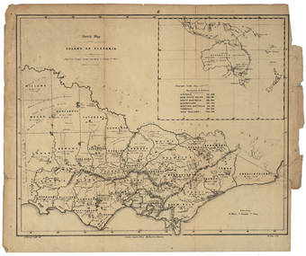 Federation University Historical Collection