Showing 561 items matching "map of mine"
-
 Coal Creek Community Park & Museum
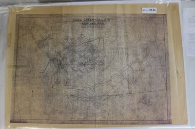
Map of Mine and Details, Coal Creek Colliery Korumburra
... Map of Mine and Details...8516.1 - Schematic/map of coal creek mine workings, also detailing number surface features such as topographic heights, roads, railways, boreholes, etc. ...Coal Creek Colliery Korumburra Map of Mine and Details ...8516.1 - Schematic/map of coal creek mine workings, also detailing number surface features such as topographic heights, roads, railways, boreholes, etc. No Legend. Most information seems to be printed, with topography drawn on. -
 Bendigo Historical Society Inc.
Document - MCCOLL, RANKIN AND STANISTREET COLLECTION: MAP OF MINE LEASES SYMONDS STREET, MCKENZIE ST WEST AREA BENDIGO, 2nd September, 1936
... MCCOLL, RANKIN AND STANISTREET COLLECTION: MAP OF MINE LEASES SYMONDS STREET, MCKENZIE ST WEST AREA BENDIGO...Document MCCOLL, RANKIN AND STANISTREET COLLECTION: MAP OF MINE LEASES SYMONDS STREET, MCKENZIE ST WEST AREA BENDIGO ...Blue waxed linen paper map. On top' Mining District of Bendigo' Parish of Sandhurst, County of Bendigo' Map shows lease 10135, area 32.1.19; lease 10371, area 30.0.23; lease 10179 area 41.3.4; lease 10370, area 49.0.1. Map indicates gully leading into and State Rivers and Water supply reservoir, water race; siphon, shaft, dam, residential area and some residential lots marked. Streets include Holly Street, MacKenzie Street West, Symonds Street, Aspinall Street, Emmett Street; Bendigo Creek marked at bottom of map. Scale 4 chains to one inch. Map is not dated.bendigo, mining, mccoll rankin & stanistreet -
 Bendigo Historical Society Inc.
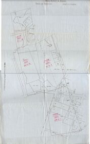
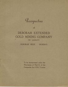
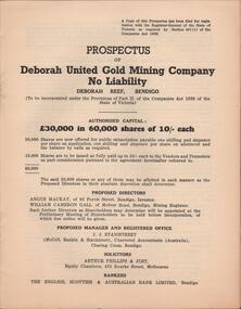
Document - MCCOLL, RANKIN AND STANISTREET COLLECTION: DEBORAH EXTENDED GOLD MINING COMPANY NL, 1940
... ...map of mine...Application form and map of mines included in book form, dated 1940. ...Application form and map of mines included in book form, dated 1940. ...McColl Rankin & Stanistreet, 12 Copies of Prospectus of Deborah Extended Gold Mining Company No Liability, Deborah Reef, Bendigo. To be incorporated under the Provisions of Part II, of the Companies Act 1938, Victoria. Application form and map of mines included in book form, dated 1940. Profit and Loss Account for Term ended 31st August, 1945 also included on separate sheet (has been folded in half across). Auditors: Wm. R. McKie & W. J. Sparkman.organization, mining, deborah extended gold mining cpy nl, mccoll rankin & stanistreet, deborah extended gold mining company nl, prospectus, profit and loss account for 31 august 1945, map of mine, form application -
 Bendigo Historical Society Inc.
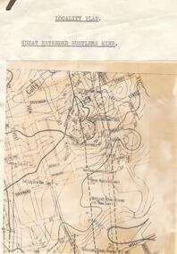
Map - GREAT EXTENDED HUSTLERS MINE - LOCALITY MAP OF GREAT EXTENDED HUSTLERS MINE
... GREAT EXTENDED HUSTLERS MINE - LOCALITY MAP OF GREAT EXTENDED HUSTLERS MINE...Mine... Locality Map of Great Extended Hustlers Mine...Location map showing the Hustlers line of mines. Map has contours with heights. ...Map is pasted onto a larger piece of paper. Map GREAT EXTENDED HUSTLERS MINE - LOCALITY MAP OF GREAT EXTENDED HUSTLERS MINE ...Location map showing the Hustlers line of mines. Map has contours with heights. Mines are named and most of them have the depth printed beside the name. Street names are also included. Map is pasted onto a larger piece of paper.mine, gold, great extended hustlers., great extended hustlers mine, locality map of great extended hustlers mine, great extended hustlers trib shaft, hustlers extended, imperial hustlers shaft, royal hustlers shaft, hustlers royal reserve park shaft, hustlers royal reserve no 2, garden gully e shaft, the golden one shaft -
 Bendigo Historical Society Inc.
Map - DEBORAH MINE - MAP OF LINES OF REEF AND MINES (BENDIGO)
... DEBORAH MINE - MAP OF LINES OF REEF AND MINES (BENDIGO)......Deborah Mine... Map...Map is a beige colour with darker lines and letters. Some of the mines have their depths printed beside them. ...This item is stored in Map drawer 7 Map DEBORAH MINE - MAP OF LINES OF REEF AND MINES (BENDIGO) ...Two adjoining photocopies of part of map of Bendigo Goldfield showing lines of reef, mines, streets, locations and contour lines. Map is a beige colour with darker lines and letters. Some of the mines have their depths printed beside them. This item is stored in Map drawer 7mine, gold, deborah mine, deborah mine, map of lines of reef and mines (bendigo). -
Clunes Museum
Map
... Map of Clunes mine...Clunes Museum 36 Fraser Street enter building through Collins Place Clunes goldfields Map of Clunes mine South Clunes United Co. No.4 Shaft Nil Photocopy of sections of Clunes gold mines, South Clunes United Co. 770 Feet, South No.4 Shaft, looking South Map MAP ...Photocopy of sections of Clunes gold mines, South Clunes United Co. 770 Feet, South No.4 Shaft, looking SouthNilmap of clunes mine, south clunes united co., no.4 shaft -
 Bendigo Historical Society Inc.
Document - MCCOLL, RANKIN AND STANISTREET COLLECTION: PROSPECTUS OF DEBORAH UNITED GOLD MINING COMPANY NL, DEBORAH REEF, 1940
... Prospectus of Deborah United Gold Mining Company. Includes map of mines...Prospectus of Deborah United Gold Mining Company. Includes map of mines Document MCCOLL, RANKIN AND STANISTREET COLLECTION: PROSPECTUS OF DEBORAH UNITED GOLD MINING COMPANY NL, DEBORAH REEF ...Document: McColl, Rankin and Stanistreet: , grey booklet. Prospectus of Deborah United Gold Mining Company. Includes map of minesorganization, mining, mccoll, rankin and stanistreet: , deborah united gold mining company nl, deborah reef, prospectus -
 Bendigo Historical Society Inc.
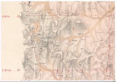
Map - DIAMOND HILL AREA
... Copy of map of Diamond Hill area, with the Trig Station mid centre on map. Shafts, mines and geological features are marked....History House 11 Mackenzie Street Bendigo goldfields BENDIGO Mining diamond hill Copy of map of Diamond Hill area, with the Trig Station mid centre on map. Shafts, mines and geological features are marked. ...Copy of map of Diamond Hill area, with the Trig Station mid centre on map. Shafts, mines and geological features are marked.bendigo, mining, diamond hill -
Clunes Museum
Pamphlet, BUSINESS & TOURISM, BURIED RIVERS OF GOLD, 2021
... MAP OF DEEP LEAD MINES, CRESWICK. WALKING TOUR...INCLUDES MAP AND INFORMATION FOR SELF GUIDED TOUR. MAP OF THE DEEP LEAD MINES, CRESWICK, AND NOTES FOR YOUR SELF-GUIDED TOUR....Clunes Museum 36 Fraser Street enter building through Collins Place Clunes goldfields MAP OF DEEP LEAD MINES, CRESWICK. WALKING TOUR GOLD MINING CRESWICK COLOURED PAMPHLET FOLDED TO DL SIZE. ...MAP OF DEEP LEAD MINES, CRESWICK. WALKING TOURCOLOURED PAMPHLET FOLDED TO DL SIZE. INCLUDES MAP AND INFORMATION FOR SELF GUIDED TOUR. MAP OF THE DEEP LEAD MINES, CRESWICK, AND NOTES FOR YOUR SELF-GUIDED TOUR.gold mining, creswick -
 Bendigo Historical Society Inc.
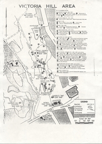
Document - VICTORIA HILL - SKETCH MAP - VICTORIA HILL
... Hand drawn sketch map of mines and depth. Some have distances between the shafts. ...History House 11 Mackenzie Street Bendigo goldfields DOCUMENT Gold Victoria Hill Sketch Map - Victoria Hill Great Central Victoria Ballerstedt Humboldt Sterry's Hand drawn sketch map of mines and depth. Some have distances between the shafts. ...Hand drawn sketch map of mines and depth. Some have distances between the shafts. Mines mentioned are: Great Central Victoria, Ballerstedt, Humboldt and Sterry's.document, gold, victoria hill, sketch map - victoria hill, great central victoria, ballerstedt, humboldt, sterry's -
 Bendigo Historical Society Inc.
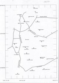
Document - CENTRAL DEBORAH GOLD MINE : GOLDEN SQUARE MINE SITES
... Map showing mines in the Golden Square, Diamond Hill area. ...Latitude and Longitude on map. Document CENTRAL DEBORAH GOLD MINE : GOLDEN SQUARE MINE SITES ...Map showing mines in the Golden Square, Diamond Hill area. Roads include Diamond Hill Road, Burns Street, Woodward Road, Belle Vue Road, Houston Street. Latitude and Longitude on map.bendigo, mining, golden square mine sites -
 Bendigo Historical Society Inc.
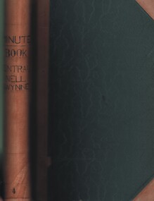
Document - MCCOLL, RANKIN AND STANISTREET COLLECTION: CENTRAL NELL GWYNNE GMC N L - MINUTE BOOK, 1946 - 1955
... Dated 20/12/1946 - 24/6/1955. 2 hand drawn maps of mine on drafting paper. Letters re sale of buildings, battery & equipment for cost of 7500 pound. ...Dated 20/12/1946 - 24/6/1955. 2 hand drawn maps of mine on drafting paper. Letters re sale of buildings, battery & equipment for cost of 7500 pound. ...Document. Leather bound (tan) green cardboard cover. Hand written minute book. Dated 20/12/1946 - 24/6/1955. 2 hand drawn maps of mine on drafting paper. Letters re sale of buildings, battery & equipment for cost of 7500 pound. Complete description of battery.McColl, Rankin & Stanistreetorganization, business, central nell gwynne, mccoll, rankin & stanistreet, central nell gwynne gmc n l, gold mining, minute book -
 Bendigo Historical Society Inc.
Document - PLAN SHOWING THE VARIOUS CLAIMS ON THE NEW CHUM VICTORIA , ST MUNGO & DEVONSHIRE REEFS BENDIGO
... Map of mines - calico scroll showing locations of various claims .printed in black ink on off-white Calico with turned wooden ends on scroll -missing one wooden end , some stains and creasing / Plan showing the various Claims on the New Chum Victoria , St Mungo & Devonshire reefs Bendigo...History House 11 Mackenzie Street Bendigo goldfields ORGANIZATION Mining industrial W Holmes printer & lithographer Sandhurst/New Cum Victoria St Mungo & Devonshire reefs Bendigo W Holmes , printer & lithographer , Sandhurst Map of mines - calico scroll showing locations of various claims .printed in black ink on off-white Calico with turned wooden ends on scroll -missing one wooden end , some stains and creasing / Plan showing the various Claims on the New Chum Victoria , St Mungo & Devonshire reefs Bendigo Document PLAN SHOWING THE VARIOUS CLAIMS ON THE NEW CHUM VICTORIA , ST MUNGO & DEVONSHIRE REEFS BENDIGO ...Map of mines - calico scroll showing locations of various claims .printed in black ink on off-white Calico with turned wooden ends on scroll -missing one wooden end , some stains and creasing / Plan showing the various Claims on the New Chum Victoria , St Mungo & Devonshire reefs BendigoW Holmes , printer & lithographer , Sandhurstorganization, mining, industrial, w holmes , printer & lithographer , sandhurst/new cum , victoria st mungo & devonshire reefs bendigo -
 Bendigo Historical Society Inc.
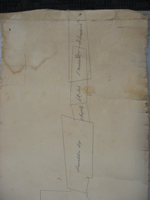
Map - STRUGNELL COLLECTION: UNDERGROUND SURVEY OF MINES, BENDIGO, 20-3-01
... Map, Underground Survey of Mines, Bendigo.Shenandoah Co., New Chum Line,...H.S.Whitelaw Map, Underground Survey of Mines, Bendigo.Shenandoah Co., New Chum Line, Map STRUGNELL COLLECTION: UNDERGROUND SURVEY OF MINES, BENDIGO. ...Map, Underground Survey of Mines, Bendigo.Shenandoah Co., New Chum Line,H.S.Whitelawmap, bendigo, shenandoah co. -
 Bendigo Historical Society Inc.
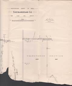
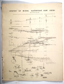
Map - SURVEY OF MINES, SANDHURST, NEW CHUM, Circa 1881
... Map: Survey of Mines, Sandhurst, New Chum, Longtitudinal Section of the New Chum, reef. 2 sheets. ...Sheet 5 and Sheet 8 Map SURVEY OF MINES, SANDHURST, NEW CHUM ...Map: Survey of Mines, Sandhurst, New Chum, Longtitudinal Section of the New Chum, reef. 2 sheets. Sheet 5 and Sheet 8map, mining plan, survey of mines , sandhurst, new chum, gold mines bendigo -
 Bendigo Historical Society Inc.
Document - Kangaroo Flat Gold Mine Collection: Bendigo Mine, Bendigo Mining NL, Unknown
... Overview of mine project in dot form on page one and map of mine development, superimposed on Google Earth image of Kangaroo Flat area, on page two. ...Overview of mine project in dot form on page one and map of mine development, superimposed on Google Earth image of Kangaroo Flat area, on page two. ...One page document, double sided, titled: 'Bendigo Mining, Facts and Figures on the Project'. Overview of mine project in dot form on page one and map of mine development, superimposed on Google Earth image of Kangaroo Flat area, on page two. On bottom of page 'Bendigo Mining Limited, 66 Ham Street, Kangaroo Flat. Vic 3555.bendigo mining n.l., bendigo, mining, gold, kangaroo flat, decline, north drive, swan decline, south decline, new moon plant eaglehawk, ventilation shaft, drilling, blasting, ground support -
 Tarnagulla History Archive
Pages from a book: Poseidon Alluvial Gold Mine, Tarnagulla, Poseidon Alluvial Gold Mine, Tarnagulla, circa 1916
... Map of the mines entire workings, above and below ground. ...Map of the mines entire workings, above and below ground. ...Murray Comrie Collection. Pages from a book (unknown), this excerpt titled 'Poseidon Alluvial Gold Mine, Tarnagulla' by O.A.L. Whitelaw, Field Geologist. Includes a map (also extracted from the book) with title 'Poseidon Alluvial Gold Mines'. Map of the mines entire workings, above and below ground. tarnagulla, poseidon, mine, mining, gold -
 Federation University Historical Collection
Plan, School of Mines and Industries: Location of buildings, Ballarat
... Printed map showing Ballarat School of Mines locations....Barker Library (top floor) Mount Helen goldfields Ballarat School of Mines plan ballarat lake wendouree Printed map showing Ballarat School of Mines locations. ...Printed map showing Ballarat School of Mines locations.ballarat school of mines, plan, ballarat, lake wendouree -
 Buninyong Visitor Information Centre
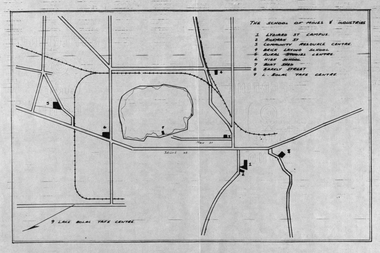
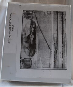
Document (item) - Folio, Buninyong Visitor Information Centre Volunteers, Mining in the Buninyong Area, 1990s
... Includes names of mining companies in the area and maps showing locations of mines. ...Buninyong Visitor Information Centre 408 Warrenheip Street Buninyong goldfields Includes names of mining companies in the area and maps showing locations of mines. Mining Gold Mining Buninyong Industry Large white plastic covered ring binder with mining sketch on the front cover. ...Includes names of mining companies in the area and maps showing locations of mines. mining, gold mining, buninyong, industry -
 Bendigo Historical Society Inc.
Map - STRUGNELL COLLECTION: UNDERGROUND SURVEY OF MINES, BENDIGO, 25-5-01
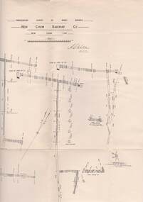
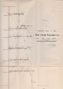
... Map, Underground Survey of Mines, Bendigo, New Chum Railway Co, New Chum Line....A.S.Whitelaw Map, Underground Survey of Mines, Bendigo, New Chum Railway Co, New Chum Line. ...Map, Underground Survey of Mines, Bendigo, New Chum Railway Co, New Chum Line.A.S.Whitelawmap, bendigo, new chum railway co. -
 Bendigo Historical Society Inc.
Map - STRUGNELL COLLECTION: UNDERGROUND SURVEY OF MINES, BENDIGO, 29-3-01
... Map, Underground Survey of Mines, New Chum Railway Co., New Chum Line, Transverse Section....A.S.Whitelaw Map, Underground Survey of Mines, New Chum Railway Co., New Chum Line, Transverse Section. ...Map, Underground Survey of Mines, New Chum Railway Co., New Chum Line, Transverse Section.A.S.Whitelawmap, bendigo, new chum railway co. -
 Ringwood and District Historical Society
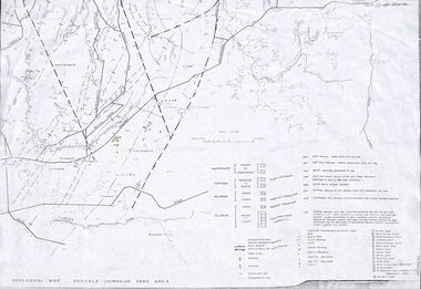
Map - Maps, Geological Map Donvale to Chirnside Park, also Victorian Railways Maps of Hawthorn to Lilydale Line incl Ringwood to East Ringwood - 1881
... Geological map includes location of mine shafts circa 1920....Geological map includes location of mine shafts circa 1920. Geological Map Donvale to Chirnside Park, also Victorian Railways Maps of Hawthorn to Lilydale Line incl Ringwood to East Ringwood - 1881 Map Maps ...Faint photocopies of sections of larger maps. Geological map includes location of mine shafts circa 1920.Victory Shaft, North Victory Shaft, South Caledonia Shaft, Caledonia Shaft, North Caledonia Shaft, Black Swan Shaft, Reward Shaft, Consols Shaft, Blocks Shaft, Devonshire Shaft, Crown Shaft, Yarra Tunnel Reef Working, Bright's Shaft, Kingwood Antimony Company Shaft (Boardman's Shaft), Southern Shaft. -
 Bendigo Historical Society Inc.
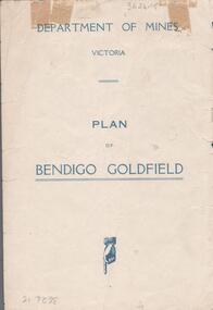
Map - BENDIGO GOLDFIELDS MAP
... On the back of map 'Department of Mines, Victoria. Plan of Bendigo Goldfield....On the back of map 'Department of Mines, Victoria. Plan of Bendigo Goldfield. ...Map of the Bendigo Goldfield, showing reef lines, mines and significant geographical features such as Monument Hill, Quartz Hill and Diamond Hill. On the back of map 'Department of Mines, Victoria. Plan of Bendigo Goldfield.bendigo, mining, bendigo goldfields -
 Coal Creek Community Park & Museum
Mine Map, 21/01/1945
... Mine Map...6298.1 - Map of Coal Creek mine tunnels, coal seams, boreholes, as well as roads and coal leura creeks....Mine Map ...6298.1 - Map of Coal Creek mine tunnels, coal seams, boreholes, as well as roads and coal leura creeks. -
Clunes Museum
Map - DOCUMENTS/MAP, 3 1887. .4 1891
... MINING, CLUNES GOLD MINES, MAPS, SECTIONS...SCALE 4 CHAINS TO AN INCH. .3 MAP OF GOLD MINING LEASE BLOCKS AT CLUNES .4 DRAWINGS OF SECTIONS, CLUNES GOLD MINES. ...Clunes Museum 36 Fraser Street enter building through Collins Place Clunes goldfields MINING, CLUNES GOLD MINES, MAPS, SECTIONS CLUNES GOLD MINING LEASES AERIAL PHOTOGRAPH MINE SECTIONS .1 ON BACK. ...MINING, CLUNES GOLD MINES, MAPS, SECTIONS.1 AERIAL VIEW OF CLUNES AND DISTRICT. COLOUR PHOTOGRAPH LAMINATED. .2 MAP OF MINING AREAS SHOWING EXCISED AREA. No. 9104. MINING DISTRICT OF BALLARAT. PARISH OF CLUNES. COUNTY OF TALBOT. SCALE 4 CHAINS TO AN INCH. .3 MAP OF GOLD MINING LEASE BLOCKS AT CLUNES .4 DRAWINGS OF SECTIONS, CLUNES GOLD MINES. SCALE 400 FEET TO AN NCH. ALL MOUNTED WITH PLASTIC HANGING STRIPS..1 ON BACK. CLUNES 1:25000 .2 ASSORTED HANDWITTEN NOTATIONS. .3 ASSORTED HANDWITTEN NOTATIONS. REPLACE IN DEPT. OF MINING REGISTRARS QUARTER ENDED 30TH JUNE 1887. P. 12.clunes, gold mining, leases, aerial photograph, mine sections -
Clunes Museum
Map
... Photocopy of map Underground Survey of mines at Clunes Clunes Goldfields Co. ...Clunes Museum 36 Fraser Street enter building through Collins Place Clunes goldfields CARTOGRAPHY CLUNES MINES CLUNES GOLDFIELD CO. Nil Photocopy of map Underground Survey of mines at Clunes Clunes Goldfields Co. ...Photocopy of map Underground Survey of mines at Clunes Clunes Goldfields Co. (two sheets joined) Port Phillip Co.Nilcartography, clunes mines, clunes goldfield co. -
 Bendigo Historical Society Inc.
Document - VICTORIA HILL - VICTORIA HILL AREA MAP
... Map also shows mine shafts and open cuts....Map also shows mine shafts and open cuts. Document VICTORIA HILL - VICTORIA HILL AREA MAP ...Photocopied map on cream paper. Map is the Victoria Hill area showing the locations of the Gold Mines Hotel, John Brown Factory and W Rae's Home. Map also shows mine shafts and open cuts.map, bendigo, victoria hill, victoria hill map, gold mines hotel, john brown factory, w rae's home, victoria consols, adventure and advance open cut, great central victoria, rae's open cut, victoria qiartz, ballerstedt's open cut, lansell's '180', north old chum, central nell gwynne -
 Bendigo Historical Society Inc.
Document - MCCOLL, RANKIN AND STANISTREET COLLECTION: DEBORAH EXTENDED GOLD MINING CO. NL, 1940
... Common Seal for: The Bank of Australasia and Deborah Ext Gold Mining Co NL. 2 maps of mine location....Common Seal for: The Bank of Australasia and Deborah Ext Gold Mining Co NL. 2 maps of mine location. Document MCCOLL, RANKIN AND STANISTREET COLLECTION: DEBORAH EXTENDED GOLD MINING CO. ...McColl Rankin & Stanistreet, Deborah Extended Gold Mining Co. No Liability, Lease. Inscription: Mortgagee under Mortgage N'bd... has consented to this Lease, See consent endorsed heron (signed) F O Hewison Assistant Registrar, Registrar of Titles 14 May 1941. Leases Copy. Other signatures: Donald McKinnon, Jean Woods, Jamie Jepson, Angus Mackay, J Stanistreet, A Gilcrist, ? Healy. Common Seal for: The Bank of Australasia and Deborah Ext Gold Mining Co NL. 2 maps of mine location.organization, mining, deborah extended gold mining co nl, mccoll rankin & stanistreet, deborah extended gold mining co nl lease -
 Bendigo Historical Society Inc.
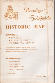
Document - BENDIGO GOLFIELDS HISTORIC MAP
... Bendigo goldfields historic map showing streets, lines of reef, principal shafts. Original map (dept of Mines) with additional material by members of RHSV (Bendigo Branch) . ...Original map (dept of Mines) with additional material by members of RHSV (Bendigo Branch) . ...Bendigo goldfields historic map showing streets, lines of reef, principal shafts. Original map (dept of Mines) with additional material by members of RHSV (Bendigo Branch) . Price 30c. Map; is folded into envelope for sale and storage.bendigo, map, goldfields, mines, tourism -
 Bendigo Historical Society Inc.
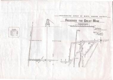
Map - STRUGNELL COLLECTION: UNDERGROUND SURVEY OF MINES, BENDIGO DISTRICT, 7-1-99
... MAP...Bendigo...frederick the great mine...Map, Underground Survey of Mines Bendigo District.Frederick the Great Mine, Sebastian. ...History House 11 Mackenzie Street Bendigo goldfields MAP Bendigo frederick the great mine A.S.Whitelaw Map, Underground Survey of Mines Bendigo District.Frederick the Great Mine, Sebastian. ...Map, Underground Survey of Mines Bendigo District.Frederick the Great Mine, Sebastian. A collection of nine (9) maps of the mine, Signed H.S.Whitelaw Field Geologist 4.1.99 with some notes relating to same, including a: * Typed overview of the operation of the mine in 1912. * Clipping from Victoria its Mines and Minerals detailing the operation of the mine from its beginning in 1863 where it was first worked for alluvial. Charlton & Co., and Mr. Glass mentioned in article.A.S.Whitelawmap, bendigo, frederick the great mine