Showing 10 items matching "map town of clunes"
-
 Clunes Museum
Map - PLAN / MAP
... MAP TOWN OF CLUNES....1 MAP, TOWN OF CLUNES, PARISH OF CLUNES, COUNTY OF TALBOT, STAMPED BOROUGH OF CLUNES .2 PLAN OF SUBDIVISION OF PART OF CLUNES COMMON, BOROUGH OF CLUNES, PARISH OF CLUNES,COUNTY OF TALBOT. ...Clunes Museum 36 Fraser Street enter building through Collins Place Clunes goldfields MAP TOWN OF CLUNES BOROUGH OF CLUNES PARISH OF CLUNES COUNTY OF TALBOT .1 PHOTO LITHOGRAPHED. ....1 MAP, TOWN OF CLUNES, PARISH OF CLUNES, COUNTY OF TALBOT, STAMPED BOROUGH OF CLUNES .2 PLAN OF SUBDIVISION OF PART OF CLUNES COMMON, BOROUGH OF CLUNES, PARISH OF CLUNES,COUNTY OF TALBOT. P. CAMPBELL. ASSISTANT SURVEYOR, MARCH 1904 ON RIGHT HAND BOTTOM CORNER C71/1 CLUNES COMMON. MARKED: CHARTED R.L.A.7/2/57.1 PHOTO LITHOGRAPHED. DEPARTMENT OF LANDS AND SURVEY, MELBOURNE .2 PHOTO LITHOGRAPHED AT THE DEP. OF LANDS AND SURVEY, MELBOURNE PRICE 1/- 10.11.08map town of clunes, borough of clunes, parish of clunes, county of talbot -
 Marysville & District Historical Society
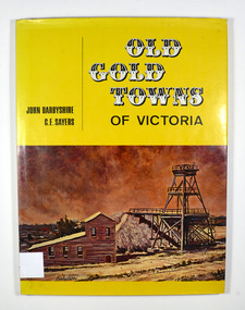
Book, Old Gold Towns of Victoria, 1970
... Clunes. Inside both front and back cover is a drawn map of Victoria showing all the towns mentioned in the book. ...town victoria australia history Stamp of the Marysville & District Historical Society Inc / P.O. Box 22 / Marysville 3779 Signature of H M Oliver Hardback. Yellow dust cover. Front of jacket illustration-The Diggings, Ballarat. The poppet head, battery house, and mullock heap are typical of an old gold mine, and have been restored on Sovereign Hill over the old North Normandy mine. Back of jacket-The Bend in the Road, at Clunes. Inside both front and back cover is a drawn map ...Histories of the old gold towns in VictoriaHardback. Yellow dust cover. Front of jacket illustration-The Diggings, Ballarat. The poppet head, battery house, and mullock heap are typical of an old gold mine, and have been restored on Sovereign Hill over the old North Normandy mine. Back of jacket-The Bend in the Road, at Clunes. Inside both front and back cover is a drawn map of Victoria showing all the towns mentioned in the book. Stamp of the Marysville & District Historical Society Inc / P.O. Box 22 / Marysville 3779 Signature of H M Olivergold town, victoria, australia, history -
 Clunes Museum
Document - MAP
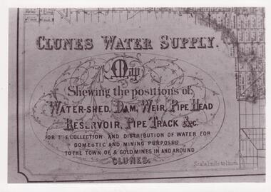
... CLUNES WATER SHED SUPPLY MAP SHEWING THE POSITION OF WATERSHED ECT. FOR THE COLLECTION AND DISTRIBUTION OF WATER FOR DOMESTIC AND MINING PURPOSES TO THE TOWN OF & GOLDMINES IN AND AROUND CLUNES....Clunes Museum 36 Fraser Street enter building through Collins Place Clunes goldfields CLUNES WATER SHED SUPPLY MAP SHEWING THE POSITION OF WATERSHED ECT. FOR THE COLLECTION AND DISTRIBUTION OF WATER FOR DOMESTIC AND MINING PURPOSES TO THE TOWN OF & GOLDMINES IN AND AROUND CLUNES. local history photographs water supply SEE PHOTOGRAPH ON BACK OF HISTORY OF OBJECT. ...CLUNES WATER SHED SUPPLY MAP SHEWING THE POSITION OF WATERSHED ECT. FOR THE COLLECTION AND DISTRIBUTION OF WATER FOR DOMESTIC AND MINING PURPOSES TO THE TOWN OF & GOLDMINES IN AND AROUND CLUNES.PHOTOCOPY SECTION OF PHOTOGRAPH AND PLAQUE AND MAP OF CLUNES WATER SUPPLY. SHOWING THE POSITION OF WATERSHED, DAM, WEIR PIPEHEAD RESERVOIR PIPE TRACK.SEE PHOTOGRAPH ON BACK OF HISTORY OF OBJECT.local history, photographs, water supply -
Clunes Museum
Document - SURVEYORS MAP, A.C. BROOKS GOVERNMENT PRINTER MELBOURNE, 1937
... CLUNES AT THE TIME. DIARY TURNED UP IN NORTH QUEENSLAND AND NOW IN POSSESSION OF A CRESWICK MAN. local history documents maps weickhardt wattleworth NO.1 SURVEYORS MAP TALBOT AND SURROUNDING TOWNS 1937. ...NO.2 COPY OF NOTES TAKEN FROM DIARY 1865 THOUGHT TO BE WRITTEN BY JESSE HOARE SMITH WHO WAS A SURVEYOR AT CLUNES AT THE TIME. DIARY TURNED UP IN NORTH QUEENSLAND AND NOW IN POSSESSION OF A CRESWICK MAN.NO.1 SURVEYORS MAP TALBOT AND SURROUNDING TOWNS 1937. NO.2 DIARY NOTES 1865 THOUGHT TO BE WRITTEN BY JESSE HOARE SMITHlocal history, documents, maps, weickhardt, wattleworth -
Clunes Museum
Pamphlet - BROCHURES
... MAP OF CLUNES, A TASTY LITTLE TOURING MAP CENTRED ON DAYLESFORD AND MT MACEDON, WALKS AND RIDES , CLUNES - SHOWING WALK FRO FRASER STREET AND AROUND CREEK. MENTION OF MT. BECKWORTH, POSTCARD WITH TOWN...MAP OF CLUNES, A TASTY LITTLE TOURING MAP CENTRED ON DAYLESFORD AND MT MACEDON, WALKS AND RIDES , CLUNES - SHOWING WALK FRO FRASER STREET AND AROUND CREEK. MENTION OF MT. BECKWORTH, POSTCARD WITH TOWN ...BROCHURES IN ENVELOPE: COLLECTION OF ADVERTISING OF CLUNES FOR DISTRIBUTION AG INFORMATION CENTRE. MAP OF CLUNES, A TASTY LITTLE TOURING MAP CENTRED ON DAYLESFORD AND MT MACEDON, WALKS AND RIDES , CLUNES - SHOWING WALK FRO FRASER STREET AND AROUND CREEK. MENTION OF MT. BECKWORTH, POSTCARD WITH TOWN NAMES, CLUNES BROCHURE DINING AND TAKE AWAY FOR HEPBURN, DAYLSFORD, MACEDON RANGES. VISITOR GUIDEtourist informaion, brochures -
Clunes Museum
Pamphlet - TOUR AND MAP, RICHARD AITKEN, TALBOT WALKING TOUR, 1988
... Clunes Museum 36 Fraser Street enter building through Collins Place Clunes goldfields PUBLISHED FOR BICENTENNIAL COMMEMORATION 1988 TALBOT TOUR MAP 1988 AITKEN PHOTO OF TALBOT TOWN HALL; HISTORY; DESCRIPTIONS OF BUILDINGS AND MAP TALBOT WALKING TOUR AND MAP. ...PUBLISHED FOR BICENTENNIAL COMMEMORATION 1988TALBOT WALKING TOUR AND MAP. PUBLISHED BY TALBOT AND CLUNES HERITAGE PROJECT. WRITTEN BY RICHARD AITKEN, 1988PHOTO OF TALBOT TOWN HALL; HISTORY; DESCRIPTIONS OF BUILDINGS AND MAPtalbot, tour, map, 1988, aitken -
Clunes Museum
Map, A.C. BROOKS GOVERNMENT PRINTER MELBOURNE, EGLINTON COUNTY OF TALBOT, 1965
... Clunes Museum 36 Fraser Street enter building through Collins Place Clunes goldfields MAP OF EGLINTON EGLINTON HISTORICAL MAP ADMINISTRATIVE STAMP ON BOTTOM LEFT AND ON THE BACK OF THE MAP ANOTHER STAMP - NORTHERN DIVISION (299) FORESTS COMMISSION BENDIGO MAP OF EGLINTON, COUNTY OF TALBOT PRINTED ON CANVAS WITH PLASTIC TAB FOR HANGING. MAP SHOWS TOWN ...MAP OF EGLINTONMAP OF EGLINTON, COUNTY OF TALBOT PRINTED ON CANVAS WITH PLASTIC TAB FOR HANGING. MAP SHOWS TOWN ALLOTMENTSADMINISTRATIVE STAMP ON BOTTOM LEFT AND ON THE BACK OF THE MAP ANOTHER STAMP - NORTHERN DIVISION (299) FORESTS COMMISSION BENDIGOeglinton, historical map -
Clunes Museum
Pamphlet, Clunes Historic Gold Town Victoria
... Text outlines the history of Clunes and depicts points of interest with map of area on back. Clunes Historic Gold Town Victoria Pamphlet PAMPHLET CLUNES MUSEUM ....1 Foolscap brochure folded in 4, coloured and black and white photos of Clunes. Text outlines the history of Clunes and depicts points of interest with map of area on back. .2 Foolscap brochure folded in 4, coloured and black and white photos of Clunes. Text outlines the history of Clunes and depicts points of interest with map of area on back.clunes gold town, clunes attractions, clunes history -
Clunes Museum
Pamphlet - BROCHURE, Shire of Talbot & Clunes, Clunes Walking Tour, 1988
... Folded black and white brochure with 56 points of interest, Clunes town map on reverse of brochure, image of Clunes Town Hall on front of brochure Multiple Copies...Map Clunes Walking Tour 50c hand written in lead pencil on front page Ramsay House 13 hand written in pencil on front page Text? Clunes Cemetery hand written in biro on front page Hand written in biro, Richard Ford built the bungalow he did not live there, he lived in Smith Street this is an error in the conservation study Folded black and white brochure with 56 points of interest, Clunes town map on reverse of brochure, image of Clunes Town Hall on front of brochure Multiple Copies Clunes Walking Tour Pamphlet BROCHURE Shire of Talbot & Clunes RICHARD AITKEN ...Folded black and white brochure with 56 points of interest, Clunes town map on reverse of brochure, image of Clunes Town Hall on front of brochure Multiple Copies50c hand written in lead pencil on front page Ramsay House 13 hand written in pencil on front page Text? Clunes Cemetery hand written in biro on front page Hand written in biro, Richard Ford built the bungalow he did not live there, he lived in Smith Street this is an error in the conservation studymap, clunes walking tour -
Clunes Museum
Map - CLUNES TOWN HALL AND COURTHOUSE COMPLEX, FALKINGER ANDRONAS
... Clunes Museum 36 Fraser Street enter building through Collins Place Clunes goldfields TOWN HALL AND COURTHOUSE DRAWINGS PROPOSED REFURBISHMENT CLUNES TOWN HALL AND COURT HOUSE COMPLEX - PROPOSED REFURBISHMENT ARCHITECT DRAWINGS: ,1 SITE AND ROOF PLAN .2 GROUND FLOOR PLAN .3 EAST ELEVATION .4 WEST ELEVATION .5 ABC/FASCADES Map CLUNES TOWN HALL AND COURTHOUSE COMPLEX FALKINGER ANDRONAS ...CLUNES TOWN HALL AND COURT HOUSE COMPLEX - PROPOSED REFURBISHMENT ARCHITECT DRAWINGS: ,1 SITE AND ROOF PLAN .2 GROUND FLOOR PLAN .3 EAST ELEVATION .4 WEST ELEVATION .5 ABC/FASCADEStown hall and courthouse drawings, proposed refurbishment