Showing 4450 items matching "mays road"
-
 Eltham District Historical Society Inc
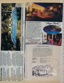
Newsclipping, 290 Mount Pleasant Road and Mays Park, 6 Mays Road, Eltham South, 1998 and Mulberry Hill, Golf Links Road, Baxter
... 290 Mount Pleasant Road and Mays Park, 6 Mays Road, Eltham South, 1998 and Mulberry Hill, Golf Links Road, Baxter......Mays Road...Eltham District Historical Society Inc 728 Main Rd Eltham melbourne Contained in Volume 2 of a set of two spiral magnetic photo albums, each containing 10 leaves, 20 pages; Vol. 1 labelled "Houses - Eltham South" and Vol. 2 labelled "Eltham Houses". eltham real estate advertisement houses Baxter Mays Park Mays Road Mount Pleasant Road Mulberry Hill Newspaper clippings promoting house auctions 290 Mount Pleasant Road and Mays Park, 6 Mays Road, Eltham South, 1998 and Mulberry Hill, Golf Links Road, Baxter Newsclipping ...Contained in Volume 2 of a set of two spiral magnetic photo albums, each containing 10 leaves, 20 pages; Vol. 1 labelled "Houses - Eltham South" and Vol. 2 labelled "Eltham Houses". Newspaper clippings promoting house auctionseltham, real estate advertisement, houses, baxter, mays park, mays road, mount pleasant road, mulberry hill -
 Eltham District Historical Society Inc
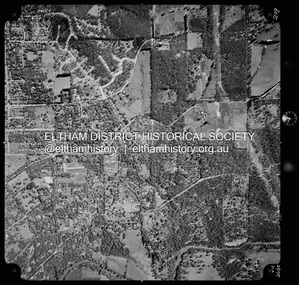
Photograph - Aerial Photograph, Landata, Eltham, Vic, Apr. 1972
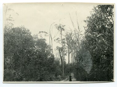
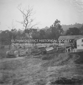
... ...Mays Road...Centred on present day Mays Road at Stringybark Road, Eltham bounded by Nyora Road to north, Yarra River to south, Reynolds Road to east and Bible Street to west. ...Eltham District Historical Society Inc 728 Main Rd Eltham melbourne Centred on present day Mays Road at Stringybark Road, Eltham bounded by Nyora Road to north, Yarra River to south, Reynolds Road to east and Bible Street to west. ...Centred on present day Mays Road at Stringybark Road, Eltham bounded by Nyora Road to north, Yarra River to south, Reynolds Road to east and Bible Street to west. Historic Aerial Imagery Source: Landata.vic.gov.au Aerial Photo Details: Project No :985 Project : MELBOURNE 1972 Run : 28 Frame : 209 Date : 04/1972 Film Type : B/W Camera : RC10 Flying Height : 5700 Scale : 9600 Film Number : 2635 GDA2020 : 37°43'33"S, 145°09'28"E MGA2020 : 337647, 5823013 (55) Melways : 22 B8 (ed. 42)aerial photo, neil webster collection, 1972-04, eltham, bible street, mays road, melway 22b8, nyora road, reynolds road, stringybark road, yarra river -
 Melton City Libraries
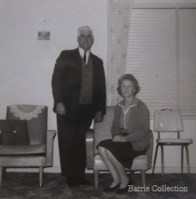
Photograph, Tom and May Barrie, c.1960s
... Tom and May at Ferris Road, Melton...Melton City Libraries 31 McKenzie Street Melton melbourne Local Identities Council Tom and May at Ferris Road, Melton Tom and May Barrie Photograph Barrie Collection ...Tom and May at Ferris Road, Meltonlocal identities, council -
 Kew Historical Society Inc
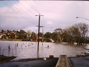
Photograph - Flooding, Kilby Road, Kew, Ron Setford, 1974
... "Flood Kilby Road / May 74"...Kilby Road -- Kew (Vic.) "Flood Kilby Road / May 74" Photograph Flooding, Kilby Road, Kew Ron Setford ...Ron Setford and his wife Grace Setford lived in Tanner Avenue, East Kew, from c.1946 to c.1995. A keen photographer, he recorded the changing face of Kew over a 20 year period. Apart from 30 photographs of built structures and places in Kew dating from 1960 and 1961, 145 of his 35mm colour slides chronicle the development of the Eastern Freeway through the Yarra Valley over a five year period from c.1972 to c.1977. This important collection was donated to the Society by his granddaughter in 2025.This collection of 175 35mm slides is of local and statewide significance, owing to its subject matter, particularly the major development of road transport infrastructure during the 1970s with the construction of the Eastern Freeway. The photographer also took care to annotate and date most of his slides which enable the researcher to pinpoint temporal and spatial locations."Flood Kilby Road / May 74"ron setford, floods -- kew (vic.), kilby road -- kew (vic.) -
 Orbost & District Historical Society
black and white photograph, May 1897
... on back - " Track near Orbost / Brodribb Road, May 1897"...Orbost & District Historical Society Ruskin Street Orbost gippsland Photo shows an unidentified lady standing on the Orbost / Brodribb Road. orbost-brodribb-road on back - " Track near Orbost / Brodribb Road, May 1897" A black / white photograph of a women in a long dress standing on a bush road surrounded by dense scrub. black and white photograph ...Photo shows an unidentified lady standing on the Orbost / Brodribb Road.A black / white photograph of a women in a long dress standing on a bush road surrounded by dense scrub.on back - " Track near Orbost / Brodribb Road, May 1897"orbost-brodribb-road -
 Whitehorse Historical Society Inc.
Photograph - B/W Photograph, Lowen family Home East Burwood, 1/06/1920 12:00:00 AM
... That section of Blackburn Road that now runs between Burwood Highway and High Street Road was originally Hewlett Road and from High Street Road to Princes Highway Was May Road....That section of Blackburn Road that now runs between Burwood Highway and High Street Road was originally Hewlett Road and from High Street Road to Princes Highway Was May Road. lowen family home east burwood Black & white photo of the Lowen home at East Burwood in the mid 1920s. ...The home of Frederick & Julia Lowen was re-located in 1933 to allow Blackburn Road (which then ended in the vicinity of what is now Hawthorn Road) to be extended through to Burwood Road (now Burwood Highway). That section of Blackburn Road that now runs between Burwood Highway and High Street Road was originally Hewlett Road and from High Street Road to Princes Highway Was May Road.Black & white photo of the Lowen home at East Burwood in the mid 1920s. The lady on the right is presumed to be Julia Lowen Fence is wire and post.lowen family home, east burwood -
 Ringwood and District Historical Society
Newspaper, Scrapbook Clipping, Library Collection, Ringwood, Victoria
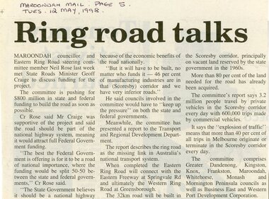
... Newspaper Clipping from the ""Mail", 12 May 1998 P5. "Ring road talks"...The committee is pushing for $800 million in state and federal funding to build the road as soon as possible. Newspaper Clipping from the ""Mail", 12 May 1998 P5. ...Newspaper Clipping from the ""Mail", 12 May 1998 P5. "Ring road talks"Maroondah councillor and Eastern Ring Road steering committee member Neil Rose last week met State Roads Minister Geoff Craige to discuss funding for the project. The committee is pushing for $800 million in state and federal funding to build the road as soon as possible. -
 Ballarat Tramway Museum
Negative - Set of 4, Warren Doubleday, May or June 1972
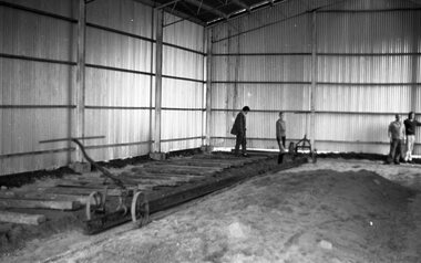
... Black and white negative - 4 scanned images - of the laying of the first track inside the BTPS depot - placing sleepers and rail on No. 3 road. May or June 1972,...Ballarat Tramway Museum South Gardens Reserve Wendouree Parade Ballarat Ballarat goldfields Trams tramways BTPS Trackwork Depot Black and white negative - 4 scanned images - of the laying of the first track inside the BTPS depot - placing sleepers and rail on No. 3 road. May or June 1972, Negative Set of 4 Warren Doubleday ...Black and white negative - 4 scanned images - of the laying of the first track inside the BTPS depot - placing sleepers and rail on No. 3 road. May or June 1972,trams, tramways, btps, trackwork, depot -
 Eltham District Historical Society Inc
Album - Photograph, J.A. McDonald, Were Street, Montmorency, Nov. 1956
... Victoria Roads construction May 1956...Eltham District Historical Society Inc 728 Main Rd Eltham melbourne Victoria Roads construction May 1956 Record of various Shire of Eltham infrastructure works undertaken during the period of 1952-1962 involving bridge and road reconstruction projects, sometimes with Eltham Shire Council Project Reference numbers quoted. ...Victoria Roads construction May 1956Record of various Shire of Eltham infrastructure works undertaken during the period of 1952-1962 involving bridge and road reconstruction projects, sometimes with Eltham Shire Council Project Reference numbers quoted. It was during this period that a number of significant improvements were made to roads and new bridges constructed within the shire that remain in place as of present day (2022). In many situations, the photos provide a tangible visible record of infrastructure that existed throughout the early days of the Shire. The album was put together by or under the direction of the Shire Engineer, J.A. McDonald.infrastructure, shire of eltham, 1956-05, briar hill fibrous plaster, bridge construction, bulldozer, montmorency, road construction, were street -
 Whitehorse Historical Society Inc.
Article, Green dream for shops
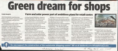
... The Burwood brickworks site in Middleborough Road may become the world's first retail centre with a living building accreditation. ...Whitehorse Historical Society Inc. 2-10 Deep Creek Road Mitcham melbourne brickworks retail trade middleborough road environment The Burwood brickworks site in Middleborough Road may become the world's first retail centre with a living building accreditation. ...The Burwood brickworks site in Middleborough Road may become the world's first retail centre with a living building accreditation. There are plans for a 10,500 sq. m. shopping centre and 750 townhouses and apartments.brickworks, retail trade, middleborough road, environment -
 Canterbury History Group
Photograph - The site of the time capsule ready to go!, City of Camberwell, 21/05/1994 12:00:00 AM
... One of eight photographs of the preparations for, and the placing of the time capsule to mark the opening of the new shops in Maling Road, 21 May 1994...Canterbury History Group 190A Canterbury Road Canterbury melbourne Canterbury Maling Road Time Capsules Shops One of eight photographs of the preparations for, and the placing of the time capsule to mark the opening of the new shops in Maling Road, 21 May 1994 Photograph The site of the time capsule ready to go! ...One of eight photographs of the preparations for, and the placing of the time capsule to mark the opening of the new shops in Maling Road, 21 May 1994canterbury, maling road, time capsules, shops -
 Eltham District Historical Society Inc
Negative - Photograph, J.A. McDonald, Eltham-Diamond Creek Road, May 1958
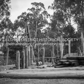
... Wing pier Eltham abutment Bridge construction Eltham-Diamond Creek road over the Diamond Creek (Wattletree Road), Eltham, May 1958...Eltham District Historical Society Inc 728 Main Rd Eltham melbourne Wing pier Eltham abutment Bridge construction Eltham-Diamond Creek road over the Diamond Creek (Wattletree Road), Eltham, May 1958 Record of various Shire of Eltham infrastructure works undertaken during the period of 1952-1962 involving bridge and road reconstruction projects, sometimes with Eltham Shire Council Project Reference numbers quoted. ...Wing pier Eltham abutment Bridge construction Eltham-Diamond Creek road over the Diamond Creek (Wattletree Road), Eltham, May 1958Record of various Shire of Eltham infrastructure works undertaken during the period of 1952-1962 involving bridge and road reconstruction projects, sometimes with Eltham Shire Council Project Reference numbers quoted. It was during this period that a number of significant improvements were made to roads and new bridges constructed within the shire that remain in place as of present day (2022). In many situations, the photos provide a tangible visible record of infrastructure that existed throughout the early days of the Shire. The album was put together by or under the direction of the Shire Engineer, J.A. McDonald.infrastructure, shire of eltham, 1958-05, bridge construction, wattletree road bridge -
Stawell Historical Society Inc
Book - Guide Book, The Emigrant's Friend
... Francis Mile End Road. May be had of all Booksellers. Inlcudes what Emigrant must provide at minimum when on passage to the colonies....Francis Mile End Road. May be had of all Booksellers. Inlcudes what Emigrant must provide at minimum when on passage to the colonies. ...Faxsimile Reprint of 1848 booklet printed in London J. Allen warwick, Paternoster Row: D. Francis Mile End Road. May be had of all Booksellers. Inlcudes what Emigrant must provide at minimum when on passage to the colonies.Paper Back, Fawn cover: Brown print Seals of Australia, New Zealand, Van Dieman's Land, and the Seal of Swan River.Seal of New Zealand Seal of Australia [Picture of Seal] [Picture of Seal] The Emigrants friend or Authentic Guide to South Australia Including Sydney: Port Philip or Australia Felix: Western Australia, or Swan River Colony: New South Wales: Van Dieman's Land; and New Zealand original published in London in 1848. Recreated by Reader's Digest Sydney [Picture of Seal] [Picture of Seal] Seal of Van Dieman's Land [Seal of Swan River] -
 Otway Districts Historical Society
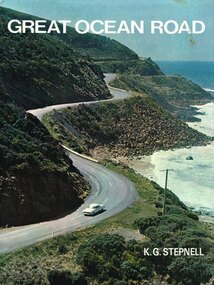
Book, Rigby Limited, Great Ocean Road. K.G. Stepnell, 1972
... The Great Ocean Road may be the only road in the world which was built as a war memorial. ...Otway Districts Historical Society Cliff Young Drive Beech Forest great-ocean-road The Great Ocean Road may be the only road in the world which was built as a war memorial. ...The Great Ocean Road may be the only road in the world which was built as a war memorial. In 1916, much of Australia was poorly served by roads, and it was suggested that returning servicemen could be given worthwhile employment by building roads in isolated areas. The plan was taken up for the Great Ocean Road, and work was dedicated to the memory of men who had fallen in World War 1. The road itself is a great feat of engineering. It wind around some of Australia's most rugged coastline. Now it is one of the world's most scenic routes, crossing gorges, along precipitous cliffs, through dense forests, and over steeply rolling coastline country.Great Ocean Road. K.G. Stepnell. 1st ed. Rigby Limited; Adelaide (S.A.); 1972. 36 p.; illus., maps. Hard cover. ISBN 0 85179 371 1great ocean road; roads; fishing; timber; twelve apostles; -
 Eltham District Historical Society Inc
Negative - Photograph, J.A. McDonald, Eltham-Diamond Creek Road, May 1958
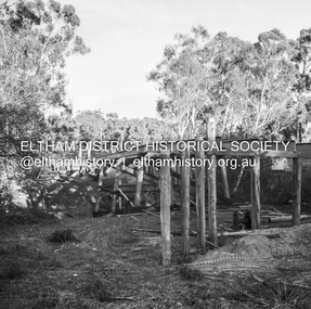
... Bridge over Diamond Creek Pile driving Diamond Creek pier Bridge construction Eltham-Diamond Creek road over the Diamond Creek (Wattletree Road), Eltham, May 1958...Eltham District Historical Society Inc 728 Main Rd Eltham melbourne Bridge over Diamond Creek Pile driving Diamond Creek pier Bridge construction Eltham-Diamond Creek road over the Diamond Creek (Wattletree Road), Eltham, May 1958 Record of various Shire of Eltham infrastructure works undertaken during the period of 1952-1962 involving bridge and road reconstruction projects, sometimes with Eltham Shire Council Project Reference numbers quoted. ...Bridge over Diamond Creek Pile driving Diamond Creek pier Bridge construction Eltham-Diamond Creek road over the Diamond Creek (Wattletree Road), Eltham, May 1958Record of various Shire of Eltham infrastructure works undertaken during the period of 1952-1962 involving bridge and road reconstruction projects, sometimes with Eltham Shire Council Project Reference numbers quoted. It was during this period that a number of significant improvements were made to roads and new bridges constructed within the shire that remain in place as of present day (2022). In many situations, the photos provide a tangible visible record of infrastructure that existed throughout the early days of the Shire. The album was put together by or under the direction of the Shire Engineer, J.A. McDonald.infrastructure, shire of eltham, 1958-05, bridge construction, wattletree road bridge -
 Eltham District Historical Society Inc
Negative - Photograph, J.A. McDonald, Eltham-Diamond Creek Road, May 1958
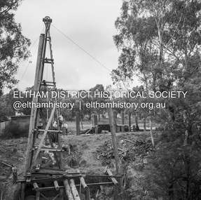
... Bridge construction Eltham-Diamond Creek road over the Diamond Creek (Wattletree Road), Eltham, May 1958 Looking from Eltham-Yarra Glen Road along future alignment...Eltham District Historical Society Inc 728 Main Rd Eltham melbourne Bridge construction Eltham-Diamond Creek road over the Diamond Creek (Wattletree Road), Eltham, May 1958 Looking from Eltham-Yarra Glen Road along future alignment Record of various Shire of Eltham infrastructure works undertaken during the period of 1952-1962 involving bridge and road reconstruction projects, sometimes with Eltham Shire Council Project Reference numbers quoted. ...Bridge construction Eltham-Diamond Creek road over the Diamond Creek (Wattletree Road), Eltham, May 1958 Looking from Eltham-Yarra Glen Road along future alignmentRecord of various Shire of Eltham infrastructure works undertaken during the period of 1952-1962 involving bridge and road reconstruction projects, sometimes with Eltham Shire Council Project Reference numbers quoted. It was during this period that a number of significant improvements were made to roads and new bridges constructed within the shire that remain in place as of present day (2022). In many situations, the photos provide a tangible visible record of infrastructure that existed throughout the early days of the Shire. The album was put together by or under the direction of the Shire Engineer, J.A. McDonald.1958-05, bridge construction, diamond creek (creek), eltham, eltham north, glen park bridge, infrastructure, shire of eltham, wattletree road bridge -
 Eltham District Historical Society Inc
Negative - Photograph, J.A. McDonald, Eltham-Diamond Creek Road, May 1958
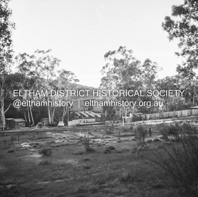
... Bridge construction Eltham-Diamond Creek road over the Diamond Creek (Wattletree Road), Eltham, May 1958 Looking toward Eltham-Yarra Glen Road from Diamond Creek abutment...Eltham District Historical Society Inc 728 Main Rd Eltham melbourne Bridge construction Eltham-Diamond Creek road over the Diamond Creek (Wattletree Road), Eltham, May 1958 Looking toward Eltham-Yarra Glen Road from Diamond Creek abutment Record of various Shire of Eltham infrastructure works undertaken during the period of 1952-1962 involving bridge and road reconstruction projects, sometimes with Eltham Shire Council Project Reference numbers quoted. ...Bridge construction Eltham-Diamond Creek road over the Diamond Creek (Wattletree Road), Eltham, May 1958 Looking toward Eltham-Yarra Glen Road from Diamond Creek abutmentRecord of various Shire of Eltham infrastructure works undertaken during the period of 1952-1962 involving bridge and road reconstruction projects, sometimes with Eltham Shire Council Project Reference numbers quoted. It was during this period that a number of significant improvements were made to roads and new bridges constructed within the shire that remain in place as of present day (2022). In many situations, the photos provide a tangible visible record of infrastructure that existed throughout the early days of the Shire. The album was put together by or under the direction of the Shire Engineer, J.A. McDonald.1958-05, bridge construction, diamond creek (creek), eltham, eltham north, glen park bridge, infrastructure, shire of eltham, wattletree road bridge -
 Clunes Museum
Photograph, PURCELL, ROGER, 1994
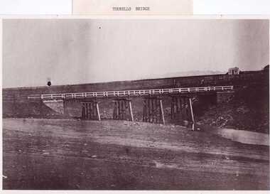
... THE PHOTOGRAPH WAS TAKEN LOOKING SOUTH WEST, THE SMALL COTTAGE SOUTH EAST OF HOLDING KNOWN AS 'STRAINS' ON THE CORNER OF BALLARAT AND COOK'S ROADS, MAY HAVE BEEN THE TOLL HOUSE. A WELL BESIDE THE COTTAGE IS STILL NEAR THE ROAD. ...THE PHOTOGRAPH WAS TAKEN LOOKING SOUTH WEST, THE SMALL COTTAGE SOUTH EAST OF HOLDING KNOWN AS 'STRAINS' ON THE CORNER OF BALLARAT AND COOK'S ROADS, MAY HAVE BEEN THE TOLL HOUSE. A WELL BESIDE THE COTTAGE IS STILL NEAR THE ROAD. ...ORIGINAL PHOTOGRAPH OWNED BY MRS. LENA COOK OF CASTLEMAINE RD. CRESWICK.. THE PHOTOGRAPH WAS TAKEN LOOKING SOUTH WEST, THE SMALL COTTAGE SOUTH EAST OF HOLDING KNOWN AS 'STRAINS' ON THE CORNER OF BALLARAT AND COOK'S ROADS, MAY HAVE BEEN THE TOLL HOUSE. A WELL BESIDE THE COTTAGE IS STILL NEAR THE ROAD. BESIDE THE NEW TOURELLO BRIDGE..1 FRAMED PHOTOGRAPH OF TOURELLO BRIDGE ON BALLARAT RD. OVER COGHILLS CREEK. .2 BLACK & WHITE PHOTOGRAPH (COPY) .3 BLACK AND WHITE COPY OF ABOVE PHOTOGRAPHlocal history, photography, photographs, bridges -
Canterbury History Group
Document - Brass rubbing of a plaque, Jan Pigot, May 1994
... Brass rubbing of the plaque in the footpath outside 78 Maling Road noting the opening of the row of new shops 60-78 Maling Road and a time capsule with material collected from every business in Maling Road in May 1994....Brass rubbing of the plaque in the footpath outside 78 Maling Road noting the opening of the row of new shops 60-78 Maling Road and a time capsule with material collected from every business in Maling Road in May 1994. Maling Road Time Capsules Brass rubbing in brown wax of a plaque Document Brass rubbing of a plaque Jan Pigot ...Brass rubbing of the plaque in the footpath outside 78 Maling Road noting the opening of the row of new shops 60-78 Maling Road and a time capsule with material collected from every business in Maling Road in May 1994.Brass rubbing in brown wax of a plaquemaling road, time capsules -
Whitehorse Historical Society Inc.
Letter - Correspondence, School 2923 Blackburn, 24/05/1978
... Payne, 6 Morton Grove, Chelsea concerning information on Blackburn Primary School, No 2923, opened in Whitehorse Road, 1 May 1889, also Sagoe Common School, Cr Whitehorse & Middleborough Roads. ...Payne, 6 Morton Grove, Chelsea concerning information on Blackburn Primary School, No 2923, opened in Whitehorse Road, 1 May 1889, also Sagoe Common School, Cr Whitehorse & Middleborough Roads. ...Letter from Neville Drummond, Victorian Education Department, History Section to Mr C.H. Payne, 6 Morton Grove, Chelsea concerning information on Blackburn Primary School, No 2923, opened in Whitehorse Road, 1 May 1889, also Sagoe Common School, Cr Whitehorse & Middleborough Roads. Also lists schools Nos 1 - 6.victoria. education department. history section, blackburn primary school, no. 2923, sagoe common school, no. 463, primary schools -
 Bendigo Historical Society Inc.
Document - MINING REPORTS - CATHERINE REEF UNITED MINE MANAGERS REPORTS
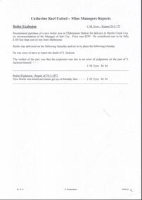
... Coakes 18th May, 1905. Truck road from the shaft to the battery. ...Coakes 18th May, 1905. Truck road from the shaft to the battery. ...Handwritten notes, with typed transcript of same, on Catherine Reef United Mine Manager, J. M. Eyre Report 20/5/'72. Recommends the purchase of a new boiler. S. Jackson killed in a boiler explosion which the jury said was due to an error of judgement on his part. Recommendations, re New Winding Engine and Poppet Legs by Rbt. Coakes 18th May, 1905. Truck road from the shaft to the battery. Recommendation to call for tenders for a new changing house and a blacksmith shop. Reports about boilers, ropes, cleaning of machinery, testing of brakes, slack coal from the Powlett North Woolamai Collieries, crushings, number of batteries, low wood supply and a visit to the New Moon & South New Moon which are burning the Powlett slack coal. Albert Richardson Collectiondocument, gold, mining reports, mining reports, catherine reef united mine managers reports, j m eyre, myrtle creek coy, s jackman, rbt coakes, great northern co, virginia co, mr roberts, mr harkness, mr mcgrath, ernest mueller, roberts & sons, mr bennett, mr abrahams, mr sluyterman, j langdon, electrical supply coy, smiths, powlett north woolamai collieries, m j gwatkins, new moon, south new moon -
 Melbourne Tram Museum
Ephemera - Timetable, Melbourne & Metropolitan Tramways Board (MMTB), Set of 13 Timetables MMTB, Oct 1966 to July 1969
... All to the City unless noted. .1 - North Richmond - Prahran - St Kilda Beach - June 1969 .2 - Essendon Aerodrome - Nov. 1968 .3 - East Preston - July 1969 .4 - West Preston - Feb. 1969 .5 - Northcote via St Georges Road - May 1967 .6 - South Melbourne Beach - Oct. 1966 .7 - North Coburg - Feb. 1969 .8 - East Coburg - Feb. 1969 .9 - West Maribyrnong - Nov. 1968 .10 - Essendon (Niddrie) - Feb. 1969 .11 - Moonee Ponds - Footscray - Feb. 1969 .12 - Domain Road - City - April 1967...All to the City unless noted. .1 - North Richmond - Prahran - St Kilda Beach - June 1969 .2 - Essendon Aerodrome - Nov. 1968 .3 - East Preston - July 1969 .4 - West Preston - Feb. 1969 .5 - Northcote via St Georges Road - May 1967 .6 - South Melbourne Beach - Oct. 1966 .7 - North Coburg - Feb. 1969 .8 - East Coburg - Feb. 1969 .9 - West Maribyrnong - Nov. 1968 .10 - Essendon (Niddrie) - Feb. 1969 .11 - Moonee Ponds - Footscray - Feb. 1969 .12 - Domain Road - City - April 1967 Set of 13 Timetables MMTB Ephemera Timetable Melbourne & Metropolitan Tramways Board (MMTB) ...Set of 13 Timetables - printed or photocopied on foolscap paper for weekdays, Saturdays and Sunday and running times. Has various symbols for depot run in etc. In a style for public use. All to the City unless noted. .1 - North Richmond - Prahran - St Kilda Beach - June 1969 .2 - Essendon Aerodrome - Nov. 1968 .3 - East Preston - July 1969 .4 - West Preston - Feb. 1969 .5 - Northcote via St Georges Road - May 1967 .6 - South Melbourne Beach - Oct. 1966 .7 - North Coburg - Feb. 1969 .8 - East Coburg - Feb. 1969 .9 - West Maribyrnong - Nov. 1968 .10 - Essendon (Niddrie) - Feb. 1969 .11 - Moonee Ponds - Footscray - Feb. 1969 .12 - Domain Road - City - April 1967Most have the name of the Depot worked from and the date in the top right hand corner in ink.trams, tramways, mmtb, timetables, buses, trams, north richmond, prahran, st kilda, essendon airport, east preston, west preston, northcote, south melbourne beach, north coburg, east coburg, west maribyrnong, essendon, moonee ponds, footscray, domain rd -
![Wal Ives & Bert [Watson] at the outlet of the Kew Main Drain](/media/collectors/550653872162f11fb04854aa/items/61593ef27608a87f688412b1/item-media/61594a5a7608a87f68848c29/item-fit-380x285.jpg?cb=6) Kew Historical Society Inc
Kew Historical Society IncPhotograph - Wal Ives & Bert [Watson] at the outlet of the Kew Main Drain, c.1900
... In August 1864, the Council called for tenders to erect a stone culvert and embankment over Connor's Creek, on Belford-road. This may be the embankment on which the boys are sitting....In August 1864, the Council called for tenders to erect a stone culvert and embankment over Connor's Creek, on Belford-road. This may be the embankment on which the boys are sitting. connors creek -- kew (vic) wal ives albert watson belford road yarra river -- kew (vic.) creeks -- kew (vic.) drains -- kew (vic.) ...Connor's Creek is/was one of two major waterways bisecting Kew, both of which empty into the Yarra River. Connor's Creek originates near the grounds of Genazzano FCJ College, which is one of the highest points in Kew. Until the 1930s, this was an open creek until a barrel drain - the Kew Main Drain - was constructed. As the creek ran through Kew it cut across a number of roads the maintenance of which was a continuing concern for Kew Councillors. In August 1864, the Council called for tenders to erect a stone culvert and embankment over Connor's Creek, on Belford-road. This may be the embankment on which the boys are sitting.Original, small photographic positive on card of two boys, identified by the donor as 'Wal Ives and Bert' [Albert Watson] sitting on bluestone capping above an outlet of Connor's Creek. To the left of the boys is a barrel drain which at that stage was the outlet for Connor's Creek near the Yarra River. The retaining wall is constructed of brick. In ink on photo: "Wal & Bert"connors creek -- kew (vic), wal ives, albert watson, belford road, yarra river -- kew (vic.), creeks -- kew (vic.), drains -- kew (vic.) -
 Kew Historical Society Inc
Plan - Subdivision Plan, Wimba Estate, Kew, c.1925-c.1929, ca. 1925-ca. 1929
... The subdivision took its name from the house ‘Wimba’ in Cotham Road, which may have formed the southern boundary of the subdivision. ...The subdivision took its name from the house ‘Wimba’ in Cotham Road, which may have formed the southern boundary of the subdivision. ...Pru Sanderson, in her groundbreaking ‘City of Kew Urban Conservation Study : Volume 2 - Development History’ (1988), summarised the periods of urban development and subdivisions of land in Kew. The periods that she identified included 1845-1880, 1880-1893, 1893-1921, 1921-1933, 1933-1943, and Post-War Development. These periods were selected as they represented periods of rapid growth or decline in urban development. An obvious starting point for Sanderson’s groupings involved population growth and the associated economic cycles. These cycles also highlighted urban expansion onto land that was predominantly rural, although in other cases it represented the decline and breakup of large estates. A number of the plans in the Kew Historical Society’s collection can also be found in other collections, such as those of the State Library of Victoria and the Boroondara Library Service. A number are however unique to the collection.Subdivision plans are historically important documents used as evidence of the growth of suburbs in Australia. They frequently provide information about when the land was sold on which a built structure was subsequently constructed as well as evidence relating to surveyors and real estate and financial agents. The numerous subdivision plans in the Kew Historical Society's collection represent working documents, ranging from the initial sketches made in planning a subdivision to printed plans on which auctioneers or agents listed the prices for which individual lots were sold. In a number of cases, the reverse of a subdivision plan in the collection includes a photograph of a house that was also for sale by the agent. These photographs provide significant heritage information relating house design and decoration, fencing and household gardens.In 1925, the City of Kew called for tenders for the construction of Wimba Avenue, Cadow Street and Lalla Street. Subsequent advertisements for the sale of land in Wimba Avenue continued from 1926 to 1929. The 18 lots (and a further five allotments on the eastern side of the street) offered for sale were unofficially described in the subdivision plan as the ‘Wimba Estate’. These lots began in Park Hill Road and extended almost to Cotham Road. The subdivision took its name from the house ‘Wimba’ in Cotham Road, which may have formed the southern boundary of the subdivision. (Wimba, at 235 Cotham Road was constructed between 1862-70). The Plan highlights the proximity and advantage of ‘electric’ trams in Cotham and Glenferrie Roads, and the Kew and Glenferrie Railway Stations. An oddity in the Plan is the reference to the electric tram terminus at Burke Road, given that the tramline had already been extended to Mont Albert in 1916.wimba estate, subdivision plans - kew, parkhill road – kew (vic.), normanby road – kew (vic.), wimba avenue – kew (vic.) -
 Mt Dandenong & District Historical Society Inc.
Photograph
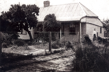
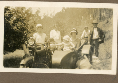
... The woman without the hat standing to the LHS appears to be Ethel Child.The location is most likely the road outside the Child Family Homestead of Ted and Ethel Child - Childs Road. Ivy May Child (1910 – 1989) was the daughter of Arthur Edward (Ted) Child (1878 – 1964) and Ethel May Madden (1888 – 1970). ...The woman without the hat standing to the LHS appears to be Ethel Child.The location is most likely the road outside the Child Family Homestead of Ted and Ethel Child - Childs Road. Ivy May Child (1910 – 1989) was the daughter of Arthur Edward (Ted) Child (1878 – 1964) and Ethel May Madden (1888 – 1970). ...The photograph is from the album of Ivy Child. Everyone in the photograph is well dressed for a day of visiting. The woman without the hat standing to the LHS appears to be Ethel Child.The location is most likely the road outside the Child Family Homestead of Ted and Ethel Child - Childs Road. Ivy May Child (1910 – 1989) was the daughter of Arthur Edward (Ted) Child (1878 – 1964) and Ethel May Madden (1888 – 1970). Ted Child was the son of Matthew Francis Child (1839 – 1933) and Martha Jeeves (1857 – 1926). He was the grandson of one of the early pioneers Francis Child. Ivy grew up on the family property on Childs Road and took many photographs. Most of these are glued into her photo album. The album covered the years from c1927 – 1932. Ivy married Henry William Burgess (1906 – 1968) in 1944. The photographs remain in their original state in the album with individual copies made. Sepia coloured photograph showing a group of people on a dirt road. A motorbike with side car is in the foreground with a woman and baby in the side car and a young woman standing beside it. Another motorbike is behind this with a young man wearing a cap sitting on it. A man wearing a hat is at the rear of the motorbike with side car and a woman without a hat is standing to the LHS. ethel child, motorbike, side car, child family homestead, kalorama -
 Melbourne Tram Museum
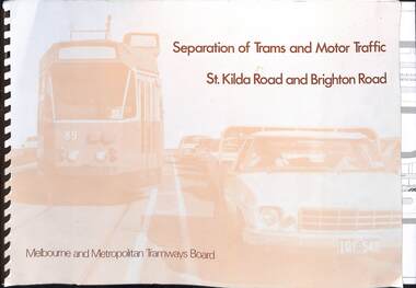
Document, Melbourne & Metropolitan Tramways Board (MMTB), "Separation of Trams and Motor Traffic - St Kilda Road and Brighton Road", May 1979
... Document prepared to provide the concepts for separation of traffic along St Kilda Road and Brighton Road using safety bars, and reserved sections of roadway between Princes Bridge and Glen Huntly Road. Dated May 1979. Has an introduction, and notes the widening of St Kilda Road south of Cochrane St and its impact. ...Melbourne Tram Museum 8 Wallen Road Hawthorn melbourne Document prepared to provide the concepts for separation of traffic along St Kilda Road and Brighton Road using safety bars, and reserved sections of roadway between Princes Bridge and Glen Huntly Road. Dated May 1979. Has an introduction, and notes the widening of St Kilda Road south of Cochrane St and its impact. ...Document prepared to provide the concepts for separation of traffic along St Kilda Road and Brighton Road using safety bars, and reserved sections of roadway between Princes Bridge and Glen Huntly Road. Dated May 1979. Has an introduction, and notes the widening of St Kilda Road south of Cochrane St and its impact. Has colour photo of Z89 in Nicholson St where the Safety bars had been installed to separate traffic, installation of Safety Zones, photos of Gothenburg, Amsterdam, and Hanover showing traffic separation, graphs showing tram passenger movement in the am peak and road usage. Looks extensively at the Domain Interchange at Park and Domain Road and the suggested layout - which was implemented in Nov. 1986. Includes a photo of a very long line of trams northbound at this intersection which has undergone many changes location, to become during 2025 the entry to Anzac station. Six drawings show the proposed separation of traffic between Alexandra Ave and Glen Huntly RoadDemonstrates a planning document to separate road traffic from trams along St Kilda Road.Comb bound document titled "Separation of Trams and Motor Traffic - St Kilda Road and Brighton Road" - 12 sheets + card covers, some full colour pages with some sheets folded.tramways, st kilda road, traffic control, domain interchange, domain road, reserved track -
 Melbourne Tram Museum
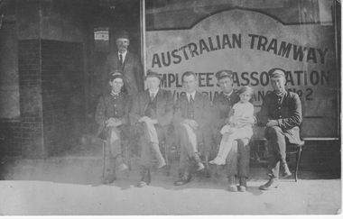
Photograph - Australian Tramway Employees Association Victorian Branch No. 2, 1915 to 1921
... This photograph of the outside the No.2 Branch office may be in Barkers Road, Kew at the Prahran and Malvern Tramways Trust's Kew Depot. ...This photograph of the outside the No.2 Branch office may be in Barkers Road, Kew at the Prahran and Malvern Tramways Trust's Kew Depot. ...Photograph shows six men and a 5 year old girl sitting on the street outside a shop front bearing signage in large print "Australian Tramway Employees Association Victorian Branch No. 2" (ATEA). Three of the men wear the uniform and cap of the Prahran and Malvern Tramway Trust and the young girl sits on the knee of one of these men. The other three men wear suits, ties and two wear hats and may be association/union officials. The ATEA was formed in 1910 and rented rooms at 636 Bourke Street from the Australian Railways Union, virtually opposite the tramways head office. This photograph of the outside the No.2 Branch office may be in Barkers Road, Kew at the Prahran and Malvern Tramways Trust's Kew Depot. This depot was opened in 1915 and included several shops in its design to help it blend into the local streetscape. The Trust was taken over by the Melbourne and Metropolitan Tramways Board in 1920 and its staff uniforms replaced over the following couple of years. This helps date the photo at between 1915 and 1921. Yields information about the Australian Tramway Employees Association Sepia photograph with postcard markings on rear. prahran and malvern tramway trust, australian tramway emplyees association, atea, 1910, 636 bourke street, melbourne and metropolitan tramways board, australian railways union, kew depot, barkers road, several shops, staff uniforms -
 Ringwood and District Historical Society
Document - Research Folder, Helm Family, Oban Road, Ringwood, Victoria - 1917-2008
... Road, Barnsdale Way, Loughies Track, 1997. Certificate of Title Vol 4029 Fol 805702 Ellen Elizabeth Helm dated 8th February 1917. Transfer of Land (2093031) payment to James William Dartnell by Alma Mary Helm and Elsie May Helm of Oban Road, Ringwood North - 13th August, 1947. ...Road, Barnsdale Way, Loughies Track, 1997. Certificate of Title Vol 4029 Fol 805702 Ellen Elizabeth Helm dated 8th February 1917. Transfer of Land (2093031) payment to James William Dartnell by Alma Mary Helm and Elsie May Helm of Oban Road, Ringwood North - 13th August, 1947. ...Transcription of conversation with Alma and Kelly Helm by Richard Carter (Past President of Ringwood Historical Society) and Larraine Haslam on 18 July 2008 detailing family history. Certificates of title of land between Oban Road and Mullum Mullum Creek. Six and a half acres sold to the Helm Family in 1917. Includes Certificate of Title Vol 5311 Fol 1062052 Carolyn Mary Glynn dated 27 April 1927. Certificate of Title Vol 4023 Fol 804560 Robert Beckett dated 19th January 1917. Plans of Subdivision including Oban Road, Barnsdale Way, Loughies Track, 1997. Certificate of Title Vol 4029 Fol 805702 Ellen Elizabeth Helm dated 8th February 1917. Transfer of Land (2093031) payment to James William Dartnell by Alma Mary Helm and Elsie May Helm of Oban Road, Ringwood North - 13th August, 1947. -
 Melbourne Tram Museum
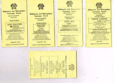
Ephemera - Timetable/s, Melbourne & Metropolitan Tramways Board (MMTB), "MMTB Tram Timetables", 1975
... All printed on yellow paper unless noted otherwise. .1 - Route 3 - East Malvern 3 - Bus Route Sundays Only, Feb. 1975 .2 - Route 5, 35 - Malvern - City .3 - Route 6, 7, 36 - Glen Iris - City .4 - Route 19, 18, 20 - North Coburg - City and Sundays only - Fawkner to Gowrie, Upfield - May 1975 .5 - Route 55, 56, 68 - West Coburg - City - Domain Road - May 1975 .6 - Route 57, 54, 60, 58 and 50 - West Maribyrnong - City - Feb. 1975 .7 - Route 64, 65, 62, 61 - East Brighton - City - June 1975 .8 - Route 66, 67 and 37 - Carnegie - City - June 1975 .9 - Route 82 - Footscray - Highpoint West - Moonee Ponds (Bus service Saturday afternoons and Sundays - November 1975. ...All printed on yellow paper unless noted otherwise. .1 - Route 3 - East Malvern 3 - Bus Route Sundays Only, Feb. 1975 .2 - Route 5, 35 - Malvern - City .3 - Route 6, 7, 36 - Glen Iris - City .4 - Route 19, 18, 20 - North Coburg - City and Sundays only - Fawkner to Gowrie, Upfield - May 1975 .5 - Route 55, 56, 68 - West Coburg - City - Domain Road - May 1975 .6 - Route 57, 54, 60, 58 and 50 - West Maribyrnong - City - Feb. 1975 .7 - Route 64, 65, 62, 61 - East Brighton - City - June 1975 .8 - Route 66, 67 and 37 - Carnegie - City - June 1975 .9 - Route 82 - Footscray - Highpoint West - Moonee Ponds (Bus service Saturday afternoons and Sundays - November 1975. ...Set of 9 MMTB Tram timetables, folded sheets, generally 10 sections, providing timetables for specific routes, day of week giving information on tram times at specific time points, route map, sections and fares and organisation address - 616 Little Collins St. Melbourne. All printed on yellow paper unless noted otherwise. .1 - Route 3 - East Malvern 3 - Bus Route Sundays Only, Feb. 1975 .2 - Route 5, 35 - Malvern - City .3 - Route 6, 7, 36 - Glen Iris - City .4 - Route 19, 18, 20 - North Coburg - City and Sundays only - Fawkner to Gowrie, Upfield - May 1975 .5 - Route 55, 56, 68 - West Coburg - City - Domain Road - May 1975 .6 - Route 57, 54, 60, 58 and 50 - West Maribyrnong - City - Feb. 1975 .7 - Route 64, 65, 62, 61 - East Brighton - City - June 1975 .8 - Route 66, 67 and 37 - Carnegie - City - June 1975 .9 - Route 82 - Footscray - Highpoint West - Moonee Ponds (Bus service Saturday afternoons and Sundays - November 1975. See Reg Item 2886 for a tramway check ticket for use on the Upfield line.trams, tramways, mmtb, timetables, melbourne, fares, upfield, bus replacement, route 3, route 5, route 6, route 7, route 18, route 19, route 20, route 35, route 36, route 37, route 50, route 54, route 55, route 56, route 57, route 58, route 60, route 61, route 62, route 64, route 65, route 66, route 67, route 68, route 82 -
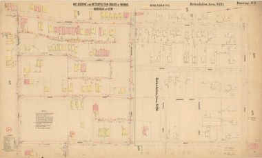 Kew Historical Society Inc
Plan, Melbourne & Metropolitan Board of Works : Borough of Kew : Detail Plan No.1571, 1904
... The first of these plans identifies the building materials used in houses bordering Fitzwilliam Street, Edgevale Road, May Street, Malin Street, Davis Street and Wellington Street. ...The first of these plans identifies the building materials used in houses bordering Fitzwilliam Street, Edgevale Road, May Street, Malin Street, Davis Street and Wellington Street. ...The Melbourne and Metropolitan Board of Works (MMBW) plans were produced from the 1890s to the 1950s. They were crucial to the design and development of Melbourne's sewerage and drainage system. The plans, at a scale of 40 feet to 1 inch (1:480), provide a detailed historical record of Melbourne streetscapes and environmental features. Each plan covers one or two street blocks (roughly six streets), showing details of buildings, including garden layouts and ownership boundaries, and features such as laneways, drains, bridges, parks, municipal boundaries and other prominent landmarks as they existed at the time each plan was produced. (Source: State Library of Victoria)This plan forms part of a large group of MMBW plans and maps that was donated to the Society by the Mr Poulter, City Engineer of the City of Kew in 1989. Within this collection, thirty-five hand-coloured plans, backed with linen, are of statewide significance as they include annotations that provide details of construction materials used in buildings in the first decade of the 20th century as well as additional information about land ownership and usage. The copies in the Public Record Office Victoria and the State Library of Victoria are monochrome versions which do not denote building materials so that the maps in this collection are invaluable and unique tools for researchers and heritage consultants. A number of the plans are not held in the collection of the State Library of Victoria so they have the additional attribute of rarity.Digital copy of the original survey plan, issued by the MMBW to a contractor with responsibility for constructing sewers in the area identified on the plan within the Borough of Kew. The plan was at some stage hand-coloured, possibly by the contractor, but more likely by officers working in the Engineering Department of the Borough and later Town, then City of Kew. The hand-coloured sections of buildings on the plan were used to denote masonry or brick constructions (pink), weatherboard constructions (yellow), and public buildings (grey). This plan is part of a large and historically significant group of MMBW plans and maps that was donated to the Society by the Mr Poulter, City Engineer of the City of Kew in 1989. When the contracts were let for surveyors to identify and record the extant houses and landscapes within an area for the Board of Works, the contracts were let at separate times, hence the anomaly where two copies of Plan No.1571 exist in our collection. The first of these plans identifies the building materials used in houses bordering Fitzwilliam Street, Edgevale Road, May Street, Malin Street, Davis Street and Wellington Street. The cut off point for the survey was the south side of Wellington Street. By 1903 when the survey was undertaken many of the sites were already built on, particularly those facing Edgevale Road. The plan identifies the preponderance of weatherboard houses in the area. The other version of the plan identifies the buildings between Wellington Street and Cotham Road.melbourne and metropolitan board of works, detail plans, mmbw 1571, cartography