Showing 43 items matching "mcdonald lane"
-
 Sunshine and District Historical Society Incorporated
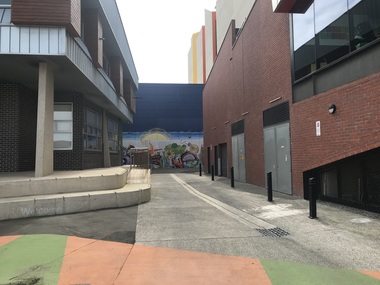
Photograph - Sunshine Laneway 2022 Photographs, John Alchin, 2022
... ...McDonald Lane...5630.01 - Bennett Place Sunshine - Rear of Sunshine Municipal Offices 2022 Photo 01.JPG 5630.02 - Bennett Place Sunshine 2022 Photo 01.JPG 5630.03 - Bennett Place Sunshine 2022 Photo 02.JPG 5630.04 - Devonshire Rd 14 Sunshine - Laneway on West Side 2022 Photo 01.JPG 5630.05 - Devonshire Rd 21 Sunshine - Laneway West Side 2022 Photo 01.JPG 5630.06 - Devonshire Rd 21 Sunshine - Laneway West Side 2022 Photo 02.JPG 5630.07 - Devonshire Rd 21 Sunshine - Laneway West Side 2022 Photo 03.JPG 5630.08 - Devonshire Rd Sunshine - Laneway between 12 And 14 2022 Photo 01.JPG 5630.09 - Devonshire Rd Sunshine - Russell St Gates 2022 Photo 01.JPG 5630.10 - Dickson St 3 Sunshine - Rear Access 2022 Photo 01.JPG 5630.11 - Durham Rd 111 - 113 Rear Sunshine 2022 Photo 01.JPG 5630.12 - Hampshire Rd 201 Sunshine - Private Access Rd North Side 2022 Photo 01.JPG 5630.13 - Mann Place Sunshine 2022 Photo 01.JPG 5630.14 - McDonald Lane 2022 Photo 03.JPG 5630.15 - McDonald Lane Sunshine 2022 Photo 01.JPG 5630.16 - Station Place 15 Sunshine - Laneway at rear 2022 Photo 01.JPG 5630.17 - Station Place 54 Sunshine - Laneway on East Side 2022 Photo 01.JPG 5630.18 - Station Place Sunshine - Rear of even number shops 2022 Photo 01.JPG 5630.19 - Station Place Sunshine - Rear of even number shops 2022 Photo 02.JPG 5630.20 - Sun Cres 12 Rear Sunshine - 2022 Photo 01.JPG 5630.21 - Watt St 18 Sunshine 2022 Photo 01.JPG 5630.22 - Sun Cres 29 Rear Sunshine - 2022 Photo 01.JPG 5630.23 - Sun Cres 29A Rear Sunshine - 2022 Photo 01.JPG 5630.24 - Sunshine Cres 31A Sunshine - Laneway on North West side 2022 Photo 01.JPG ...Sunshine Bennett Place Devonshire Road Dickson Street Durham Road Hampshire Road Mann Place McDonald Lane Station Place Watt Street Sun Crescent 5630.01 - Bennett Place Sunshine - Rear of Sunshine Municipal Offices 2022 Photo 01.JPG 5630.02 - Bennett Place Sunshine 2022 Photo 01.JPG 5630.03 - Bennett Place Sunshine 2022 Photo 02.JPG 5630.04 - Devonshire Rd 14 Sunshine - Laneway on West Side 2022 Photo 01.JPG 5630.05 - Devonshire Rd 21 Sunshine - Laneway West Side 2022 Photo 01.JPG 5630.06 - Devonshire Rd 21 Sunshine - Laneway West Side 2022 Photo 02.JPG 5630.07 - Devonshire Rd 21 Sunshine - Laneway West Side 2022 Photo 03.JPG 5630.08 - Devonshire Rd Sunshine - Laneway between 12 And 14 2022 Photo 01.JPG 5630.09 - Devonshire Rd Sunshine - Russell St Gates 2022 Photo 01.JPG 5630.10 - Dickson St 3 Sunshine - Rear Access 2022 Photo 01.JPG 5630.11 - Durham Rd 111 - 113 Rear Sunshine 2022 Photo 01.JPG 5630.12 - Hampshire Rd 201 Sunshine - Private Access Rd North Side 2022 Photo 01.JPG 5630.13 - Mann Place Sunshine 2022 Photo 01.JPG 5630.14 - McDonald Lane 2022 Photo 03.JPG 5630.15 - McDonald Lane Sunshine 2022 Photo 01.JPG 5630.16 - Station Place 15 Sunshine - Laneway at rear 2022 Photo 01.JPG 5630.17 - Station Place 54 Sunshine - Laneway on East Side 2022 Photo 01.JPG 5630.18 - Station Place Sunshine - Rear of even number shops 2022 Photo 01.JPG 5630.19 - Station Place Sunshine - Rear of even number shops 2022 Photo 02.JPG 5630.20 - Sun Cres 12 Rear Sunshine - 2022 Photo 01.JPG 5630.21 - Watt St 18 Sunshine 2022 Photo 01.JPG 5630.22 - Sun Cres 29 Rear Sunshine - 2022 Photo 01.JPG 5630.23 - Sun Cres 29A Rear Sunshine - 2022 Photo 01.JPG 5630.24 - Sunshine Cres 31A Sunshine - Laneway on North West side 2022 Photo 01.JPG Digital photographs Photograph Sunshine Laneway 2022 Photographs John Alchin ...These photographs provide a visual record of assorted laneways and street views throughout Sunshine in 2022.This collection of photographs preserves a visual record of Sunshine 2022.5630.01 - Bennett Place Sunshine - Rear of Sunshine Municipal Offices 2022 Photo 01.JPG 5630.02 - Bennett Place Sunshine 2022 Photo 01.JPG 5630.03 - Bennett Place Sunshine 2022 Photo 02.JPG 5630.04 - Devonshire Rd 14 Sunshine - Laneway on West Side 2022 Photo 01.JPG 5630.05 - Devonshire Rd 21 Sunshine - Laneway West Side 2022 Photo 01.JPG 5630.06 - Devonshire Rd 21 Sunshine - Laneway West Side 2022 Photo 02.JPG 5630.07 - Devonshire Rd 21 Sunshine - Laneway West Side 2022 Photo 03.JPG 5630.08 - Devonshire Rd Sunshine - Laneway between 12 And 14 2022 Photo 01.JPG 5630.09 - Devonshire Rd Sunshine - Russell St Gates 2022 Photo 01.JPG 5630.10 - Dickson St 3 Sunshine - Rear Access 2022 Photo 01.JPG 5630.11 - Durham Rd 111 - 113 Rear Sunshine 2022 Photo 01.JPG 5630.12 - Hampshire Rd 201 Sunshine - Private Access Rd North Side 2022 Photo 01.JPG 5630.13 - Mann Place Sunshine 2022 Photo 01.JPG 5630.14 - McDonald Lane 2022 Photo 03.JPG 5630.15 - McDonald Lane Sunshine 2022 Photo 01.JPG 5630.16 - Station Place 15 Sunshine - Laneway at rear 2022 Photo 01.JPG 5630.17 - Station Place 54 Sunshine - Laneway on East Side 2022 Photo 01.JPG 5630.18 - Station Place Sunshine - Rear of even number shops 2022 Photo 01.JPG 5630.19 - Station Place Sunshine - Rear of even number shops 2022 Photo 02.JPG 5630.20 - Sun Cres 12 Rear Sunshine - 2022 Photo 01.JPG 5630.21 - Watt St 18 Sunshine 2022 Photo 01.JPG 5630.22 - Sun Cres 29 Rear Sunshine - 2022 Photo 01.JPG 5630.23 - Sun Cres 29A Rear Sunshine - 2022 Photo 01.JPG 5630.24 - Sunshine Cres 31A Sunshine - Laneway on North West side 2022 Photo 01.JPG sunshine, bennett place, devonshire road, dickson street, durham road, hampshire road, mann place, mcdonald lane, station place, watt street, sun crescent -
 Ballaarat Mechanics' Institute (BMI Ballarat)
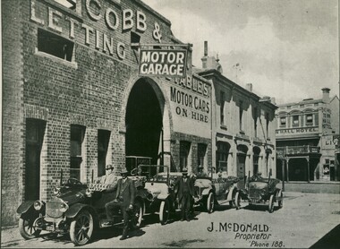
McDonald Motor Garage Bath Lane
... McDonald Motor Garage Bath Lane...Ballarat McDonald's motor garage Bath McDonald Motor Garage Bath Lane ...This photograph is from the Max Harris Collection held by the Ballaraat Mechanics' Institute. Please contact BMI for all print and usage inquiries.ballarat, mcdonald's, motor garage, bath -
 Bendigo Military Museum
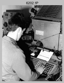
Photograph - Typesetting Equipment and Personnel, Army Survey Regiment, Fortuna, Bendigo, c1968 to 1979
... Black and white photos are on photographic paper and scanned at 300 dpi. .1) - Photo, black & white, c1960s, Fotosetter type setting machine, unidentified technician. .2) - Photo, black & white, c1960s, Fotosetter type setting machine. .3) to .4) - Photo, black & white, c1968, Fotosetter type setting machine, CPL Arty Lane. .5) to .6) - Photo, black & white, c1970s, Monotype Photolettering Machine, unidentified technician. .7) to .8) - Photo, black & white, c1979, Typesetting machine, ‘Editwriter’ Model 7500, SGT Jim McDonald. .9) - Photo, black & white, 1979, Typesetting machine, ‘Editwriter’ Model 7500, SSGT Pat Lumsden....Black and white photos are on photographic paper and scanned at 300 dpi. .1) - Photo, black & white, c1960s, Fotosetter type setting machine, unidentified technician. .2) - Photo, black & white, c1960s, Fotosetter type setting machine. .3) to .4) - Photo, black & white, c1968, Fotosetter type setting machine, CPL Arty Lane. .5) to .6) - Photo, black & white, c1970s, Monotype Photolettering Machine, unidentified technician. .7) to .8) - Photo, black & white, c1979, Typesetting machine, ‘Editwriter’ Model 7500, SGT Jim McDonald. .9) - Photo, black & white, 1979, Typesetting machine, ‘Editwriter’ Model 7500, SSGT Pat Lumsden. ...This is a set of nine photographs of cartographic typesetting equipment and personnel in Cartographic Squadron at the Army Survey Regiment, Fortuna, Bendigo circa 1968 to 1979. The rooms on the top floor of Fortuna Villa where the photos were taken were formally the nursery and boys bedrooms during the Lansell family’s occupation of the building. The Fotosetter type setting machine replaced the letterpress method of type production in 1956. Its operator entered the text using a type order provided by cartographic draughtsmen/ draughtswomen. The type was output on a film positive, which was contacted onto strip film. The text was cut out by cartographic draughtsmen/ draughtswomen and affixed onto type sheets using bees wax. Cartographic Squadron’s CPL Arty Lane specialised in the operation of the Fotosetter type setting machine for many years, as shown in photos .3P and .4P. For more information on the Fotosetter, see page 71 of Valerie Lovejoy’s book 'Mapmakers of Fortuna – A history of the Army Survey Regiment’ ISBN: 0-646-42120-4. The computer based Editwriter Model 7500 typesetting system was introduced in 1975 as a replacement to the aging Fotosetter. It was operated by a specialised technician, who generated a large variety of map type styles and sizes quickly and reliably, as well as text panels. Output on Copy proof adhesive backed stripping type film replaced messy wax and spray adhesives in 1978. The Editwriter capability supported all RASvy units and its contractor type setting requirements. SGT Jim McDonald operated the Editwriter for a couple of years in the late 1970’s. He is seen in photos .7P and .8P. reading off a type order and entering text into the computer. See item 6181.23P, photo .1P for a reduced scale photo of SGT Jim McDonald undertaking this task. Also see item 6123.12P photos .1P and .2P featuring CPL Paul Richards, who was another technician that operated the Editwriter for several years in the 1980s. The Editwriter was also operated by SSGT Pat Lumsden, as featured in photo .9P taken in 1979. The Monotype Photolettering Machine seen in photos .5P and .6P is understood to be in service for a shorter period, as it was not as productive compared to the Fotosetter and Editwriter. This is a set of nine photographs of cartographic typesetting equipment at the Army Survey Regiment, Fortuna, Bendigo, c1968 to c1979. Black and white photos are on photographic paper and scanned at 300 dpi. .1) - Photo, black & white, c1960s, Fotosetter type setting machine, unidentified technician. .2) - Photo, black & white, c1960s, Fotosetter type setting machine. .3) to .4) - Photo, black & white, c1968, Fotosetter type setting machine, CPL Arty Lane. .5) to .6) - Photo, black & white, c1970s, Monotype Photolettering Machine, unidentified technician. .7) to .8) - Photo, black & white, c1979, Typesetting machine, ‘Editwriter’ Model 7500, SGT Jim McDonald. .9) - Photo, black & white, 1979, Typesetting machine, ‘Editwriter’ Model 7500, SSGT Pat Lumsden.Personnel and equipment are identified in photos .1P to .3P. on a card. A description is provided: ‘Fotosetter: This model was used from 1956 to 1974. Where photograph was taken: Army Survey Regiment. Person in Photograph: Arty Lane. Approx date photograph taken: 1968. Any Misc Information: All type on maps was set on this machine. The operator of the machine (Ex SGT Lane) joined the Army in 1956 and was discharged in 1977. Also with Survey from 1942 to 1946. Information given by: Arty Lane’. Photo .9P is dated 1979 on the back.’royal australian survey corps, rasvy, army survey regiment, army svy regt, fortuna, asr, carto -
 Federation University Historical Collection
Photograph, Ballarat Teachers College 1950s Exies
... McDonald...Margaret Baudinette...Elsie O'Brien...Elsie Cunningham...Lenice Stuchberry...Lenice Quick...Betty Chalmers...Betty Collins...Deirdre Faye Dickinson...Deirdre Faye Nicholson...Pat Pearce...Pat Hanrahan...Joan Blaney...Joan Kemp...Joyce Van Leeuwen...Joyce Murphy...Cynthia Poole...Arthur Jennings...Ron Lane...Barker Library (top floor) Mount Helen goldfields Ballarat Teachers College is a predecessor of Federation University Dorothy Jennings Ron Chalmers Ballarat Teachers College Laurie Melgaard Kevin Cunningham John Stuchberry Don Halladay Garreth Mann Beth Walker Geoff Walker Wilf Poole Margaret McDonald Margaret Baudinette Elsie O'Brien Elsie Cunningham Lenice Stuchberry Lenice Quick Betty Chalmers Betty Collins Deirdre Faye Dickinson Deirdre Faye Nicholson Pat Pearce Pat Hanrahan Joan Blaney Joan Kemp Joyce Van Leeuwen Joyce Murphy Cynthia Poole Arthur Jennings Ron Lane Helen Lewtas Helen Oxley June Rogers June Schofield Barbara Mann Coloured photograph taken in 2014 of Ballarat Teachers College Exiting Students of the 1950s and a list of names of those in the photograph. ...Ballarat Teachers College is a predecessor of Federation UniversityColoured photograph taken in 2014 of Ballarat Teachers College Exiting Students of the 1950s and a list of names of those in the photograph.dorothy jennings, ron chalmers, ballarat teachers college, laurie melgaard, kevin cunningham, john stuchberry, don halladay, garreth mann, beth walker, geoff walker, wilf poole, margaret mcdonald, margaret baudinette, elsie o'brien, elsie cunningham, lenice stuchberry, lenice quick, betty chalmers, betty collins, deirdre faye dickinson, deirdre faye nicholson, pat pearce, pat hanrahan, joan blaney, joan kemp, joyce van leeuwen, joyce murphy, cynthia poole, arthur jennings, ron lane, helen lewtas, helen oxley, june rogers, june schofield, barbara mann -
Glen Eira Historical Society
Article - Elsternwick Park
... Lane Tim... Roberts Sandy... Leonard Tony... Cover Ian... Phillips Steven... Marmalade Trevor... Fleet Greg... Whittle Slim... Marasco Con... Warne Shane... Elsternwick... Elsternwick Hotel... Cox Charles Mr... Turner George Sir... Fairbairn Mr... Russell-Brown J. Mr... Peacock Cr.... Huntley Cr.... Taylor J.H. Mr... Elsternwick Lacrosse Club... Elsternwick Football Club... Elsternwick District Football Club... Elsternwick Junior Football Club... Victorian Amateur Football Association... Elwood Central School... Elsternwick Primary School... Australian Broadcasting Commission... McDonald...Lane Tim Roberts Sandy Leonard Tony Cover Ian Phillips Steven Marmalade Trevor Fleet Greg Whittle Slim Marasco Con Warne Shane Elsternwick Elsternwick Hotel Cox Charles Mr Turner George Sir Fairbairn Mr Russell-Brown J. Mr Peacock Cr. Huntley Cr. Taylor J.H. Mr Elsternwick Lacrosse Club Elsternwick Football Club Elsternwick District Football Club Elsternwick Junior Football Club Victorian Amateur Football Association Elwood Central School Elsternwick Primary School Australian Broadcasting Commission McDonald A.J. ...This file contains items pertaining to Elsternwick Park: 1/A clipping from the Caulfield/Port Philip Leader (titled ‘Hunter takes reins at Elsternwick’, author unspecified, 17/04/2012), which pertains to Justin Hunter being installed as the captain of the Elsternwick Amateur Football Club. 2/A clipping from the Caulfield/Port Philip Leader (titled ‘Wicks lose a champion’, by Brad Beitzel, undated), which pertains to Graham Holmes of the Elsternwick Amateur Football club dying of cancer. 3/A book titled Bazaar Beginnings: A Century of Sport at Elsternwick Park (author unspecified, undated, 37 pages), which describes the history of Elsternwick Park from 1901 to 2003, with an emphasis on sports.elsternwick park, parks and reserves, sport, sporting clubs, sportsgrounds, australian rules football, elsternwick amateur football club, elsternwick hockey club, sculthorpe a. , elsternwick park committee of management, world war 1939-1945, langford-jones andrew, dunstan mark, todd barry, price , bill, riddell mrs, riddell ken, scott arthur, coombs percy, emburey john, potter jack, holmes graham, blumfield chris, jorgensen james, baxter andrew, taft shura, hunter justin, mahony craig, beddingfield lachie, hodskiss nathan, cesario john, mcdonald jack, rose james, warren phil, gaze andrew, local history, cricket, miller keith r., burgoyne a.d. mr, beadle ken cr., bent thomas, st. kilda cricket club, south st. kilda cricket club, muntz mr, lloyd c.d. cr., fundraising events, ground improvement fund, elsternwick hall, sargood frederick sir, foote ian, hockey, victorian hockey association, elsternwick baptist cricket club, elsternwick methodist cricket club, soccer, brighton soccer club, barr alex, loghran frank, bignell bonb, pettigrew john, morrow bruce, baseball, brighton baseball club, victorian baseball league, victorian baseball association, elsternwick baseball club, brighton football club, williamson col., mcindoe rus, warburton keith, blood michael, sherrin cup, bourke mick, l.a. adamson cup, watt judy, anderson sue, connell brett, lawry bill, stackpole keith, hookes david, hurst alan, graf shaun, madden simon, dipierdimenico robert, parkin david, malthouse mick, cleary phil, madden justin, jordan ray, michael barry, carroll wayne, mildenhall bill, brown joyce, matthews alf, madigan laurie, lane tim, roberts sandy, leonard tony, cover ian, phillips steven, marmalade trevor, fleet greg, whittle slim, marasco con, warne shane, elsternwick, elsternwick hotel, cox charles mr, turner george sir, fairbairn mr, russell-brown j. mr, peacock cr., huntley cr., taylor j.h. mr, elsternwick lacrosse club, elsternwick football club, elsternwick district football club, elsternwick junior football club, victorian amateur football association, elwood central school, elsternwick primary school, australian broadcasting commission, mcdonald a.j. mr, mccutcheon r.g. mr, melbourne cricket club, victorian cricket league, wardill b. mr, melbourne & metropolitan board of works, elsternwick golf club, clubs and associations, balme kate, stevens phil, new tommy, pratt bob, elsternwick cricket club, searle barney, blundell norm, power john, gartrell rob, victorian junior cricket association, victorian turf cricket association, australian cricket board, victorian cricket association, russell simon cr. , white cameron, abbey alan, blizzard aiden, bull adam, murphy liam, scorgie stuart, tenace kane, victorian women’s cricket association, hunt reg, hatch ron, community groups, elliot matthew, fraser colin, pike arthur, young darryl, mills alf, werf pat van der, leather tom, gregory ross, fullerton norma, sharkie keith, johnson alex, dixon brian, trezise neil, rundle noel, corner donald dr., loysh len cr., french peter, francis chris, johnson cameron, miles john, de la salle old collegians club, old xavierans club, victorian amateur football association umpires’ association, hinton wayne, cultural events and activities -
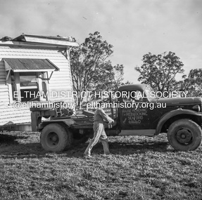
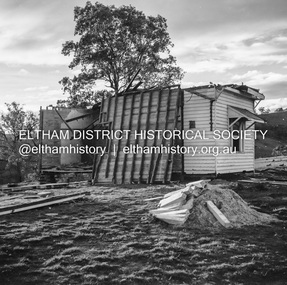
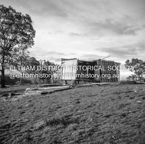
 Eltham District Historical Society Inc
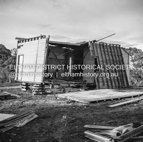
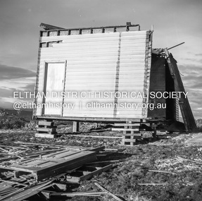
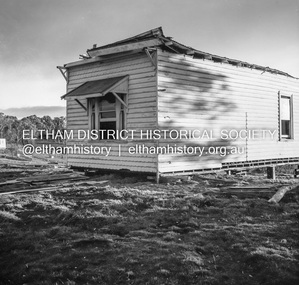
Negative - Photograph, J.A. McDonald, Inspection of storm damaged Abraham house at Kangaroo Ground, c. May 1962
... Lane). Record of various Shire of Eltham infrastructure works undertaken during the period of 1952-1962 involving bridge and road reconstruction projects, sometimes with Eltham Shire Council Project Reference numbers quoted. It was during this period that a number of significant improvements were made to roads and new bridges constructed within the shire that remain in place as of present day (2022). In many situations, the photos provide a tangible visible record of infrastructure that existed throughout the early days of the Shire. The album was put together by or under the direction of the Shire Engineer, J.A. McDonald ...Showing the effect of a wind storm that destroyed the house circa May 1962.. The Abraham family owned land near the Aqueduct and east of Nicholas Lane at Kangaroo Ground (based on photos, at or near 40 Nicholas Lane).Record of various Shire of Eltham infrastructure works undertaken during the period of 1952-1962 involving bridge and road reconstruction projects, sometimes with Eltham Shire Council Project Reference numbers quoted. It was during this period that a number of significant improvements were made to roads and new bridges constructed within the shire that remain in place as of present day (2022). In many situations, the photos provide a tangible visible record of infrastructure that existed throughout the early days of the Shire. The album was put together by or under the direction of the Shire Engineer, J.A. McDonald.1962-05, abraham house, kangaroo ground, nicholas lane, property damage, storm damage -
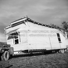
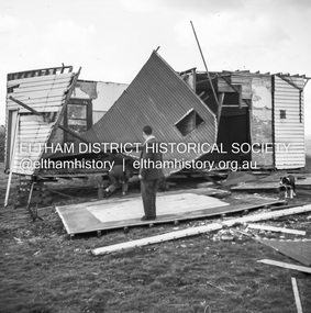
 Eltham District Historical Society Inc
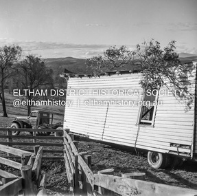
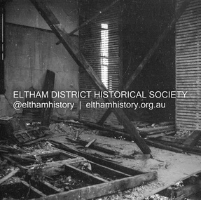
Negative - Photograph, J.A. McDonald, Removal of the remains of the Abraham house at Kangaroo Ground, c. May 1962
... Lane). Record of various Shire of Eltham infrastructure works undertaken during the period of 1952-1962 involving bridge and road reconstruction projects, sometimes with Eltham Shire Council Project Reference numbers quoted. It was during this period that a number of significant improvements were made to roads and new bridges constructed within the shire that remain in place as of present day (2022). In many situations, the photos provide a tangible visible record of infrastructure that existed throughout the early days of the Shire. The album was put together by or under the direction of the Shire Engineer, J.A. McDonald ...Martin Bros House Removing of Seaford was contracted to remove the remains of the storm damaged Abraham house from the property circa May 1962. The Abraham family owned land near the Aqueduct and east of Nicholas Lane at Kangaroo Ground (based on photos, at or near 40 Nicholas Lane).Record of various Shire of Eltham infrastructure works undertaken during the period of 1952-1962 involving bridge and road reconstruction projects, sometimes with Eltham Shire Council Project Reference numbers quoted. It was during this period that a number of significant improvements were made to roads and new bridges constructed within the shire that remain in place as of present day (2022). In many situations, the photos provide a tangible visible record of infrastructure that existed throughout the early days of the Shire. The album was put together by or under the direction of the Shire Engineer, J.A. McDonald.1962-05, abraham house, kangaroo ground, martin bros house removing seaford, nicholas lane, property damage -
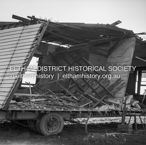
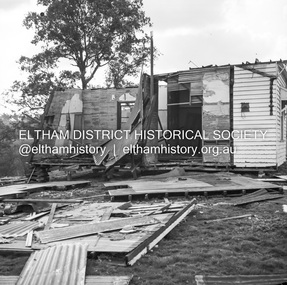
 Eltham District Historical Society Inc
Negative - Photograph, J.A. McDonald, Removal of the remains of the Abraham house at Kangaroo Ground, c. May 1962
... Lane). Record of various Shire of Eltham infrastructure works undertaken during the period of 1952-1962 involving bridge and road reconstruction projects, sometimes with Eltham Shire Council Project Reference numbers quoted. It was during this period that a number of significant improvements were made to roads and new bridges constructed within the shire that remain in place as of present day (2022). In many situations, the photos provide a tangible visible record of infrastructure that existed throughout the early days of the Shire. The album was put together by or under the direction of the Shire Engineer, J.A. McDonald ...Martin Bros House Removing of Seaford was contracted to remove the remains of the storm damaged Abraham house from the property circa May 1962. The Abraham family owned land near the Aqueduct and east of Nicholas Lane at Kangaroo Ground (based on photos, at or near 40 Nicholas Lane).Record of various Shire of Eltham infrastructure works undertaken during the period of 1952-1962 involving bridge and road reconstruction projects, sometimes with Eltham Shire Council Project Reference numbers quoted. It was during this period that a number of significant improvements were made to roads and new bridges constructed within the shire that remain in place as of present day (2022). In many situations, the photos provide a tangible visible record of infrastructure that existed throughout the early days of the Shire. The album was put together by or under the direction of the Shire Engineer, J.A. McDonald.1962-05, abraham house, kangaroo ground, martin bros house removing seaford, nicholas lane, property damage -
 Eltham District Historical Society Inc
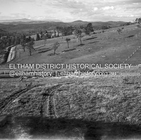
Album - Photograph Album, J.A. McDonald, Bridge and Road Reconstruction Works, Shire of Eltham, 1952-1962
... McDonald. A. Gillies Alistair Knox Park Benchmark studies Bend of Islands Blease Road Box Hill State School Box Hill Teachers College Box Hill Tip bridge construction Bridge Street Bridge Bridge Brisbane Street Brougham Steet Bulldozer Cecil Street Charis Pelling Cherry Tree Road City of Preston Cr. A. Brinkkotter Cr. Charis Pelling Cranes Cromwell Street Diamond Creek (Creek) Diamond Street Dixons Creek Bridge Dixon's Creek Road Drott Eltham Leisure Centre Eltham North Eltham Police Station Eltham Eltham-Yarra Glen Road F. Wood Fitzsimons Lane ...J.A. McDonald produced this record in the course of his responsibilities as Shire Engineer for Eltham Shire Council.Record of various Shire of Eltham infrastructure works undertaken during the period of 1952-1962 involving bridge and road reconstruction projects, sometimes with Eltham Shire Council Project Reference numbers quoted. It was during this period that a number of significant improvements were made to roads and new bridges constructed within the shire that remain in place as of present day (2022). In many situations, the photos provide a tangible visible record of infrastructure that existed throughout the early days of the Shire. The album was put together by or under the direction of the Shire Engineer, J.A. McDonald.a. gillies, alistair knox park, benchmark studies, bend of islands, blease road, box hill state school, box hill teachers college, box hill tip, bridge construction, bridge street bridge, bridge, brisbane street, brougham steet, bulldozer, cecil street, charis pelling, cherry tree road, city of preston, cr. a. brinkkotter, cr. charis pelling, cranes, cromwell street, diamond creek (creek), diamond street, dixons creek bridge, dixon's creek road, drott, eltham leisure centre, eltham north, eltham police station, eltham, eltham-yarra glen road, f. wood, fitzsimons lane bridge, flat rock road, flood damage, floods, floodwater, footpaths and gutters, ford service garage, g. blair, garden hill, glen park bridge, glenauburn road, grand hotel, haldane road, healesville, healesville-yarra glen road, heidelberg-kinglake road, henley road bridge, henley road, hill property, hurstbridge water scheme, hurstbridge, hurstbridge-arthurs creek road, infrastructure, j. jolly, kangaroo ground, kangaroo ground-queenstown road, kangaroo ground-st andrews road, lilydale shire office, long gully bridge, long gully creek, long gully road, long gully, lower plenty bridge, lower plenty footbridge, lower plenty oval, lower plenty road, lower plenty, main road, methodist church, montmorency, mount pleasant road, new holland, old healesville road, opening ceremony, oxley bridge, para road, paul creek bridge, paul creek road, paul krafeznk, pinnacle lane, plaques, plenty river trail, plenty river, presbyterian church, prof donald thomson, pryor street, railway crossing, railway parade, rattray road, reconstruction works, reichelt avenue, research (vic.), research oval, road construction, rymers corner, shire of eltham, shire of whittlesea, silvan road bridge, silver street bridge, silver street, sir dallas brooks, smedley property, st andrews, steels creek, susan street, tarrawarra, tony carberry, uniting church, upper yarra dam, upper yarra reservoir, w.e. wolf, waterfall property, watsons creek, wattletree road bridge, wattletree road, wattletree road bridge, worlingworth, yarra glen, york street, yow yow creek -
 Eltham District Historical Society Inc
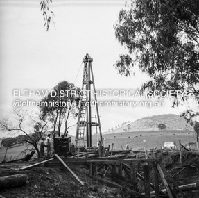
Album - Photograph, J.A. McDonald, Eltham-Templestowe Road, c. 1957
... McDonald. Infrastructure Road construction shire of eltham bridge construction Bridge Street Bridge 1957 Fitzsimons Lane Bridge Eltham-Templestowe Road Black and white photo print (location of negative unknown) Adhered to a page in an album of 78 foolscap pages containing a sequence of photos, adhered via glue or sticky tape, with typed or handwritten headings and captions in pencil. ...Site for bridge over Yarra River looking from Eltham bank.Record of various Shire of Eltham infrastructure works undertaken during the period of 1952-1962 involving bridge and road reconstruction projects, sometimes with Eltham Shire Council Project Reference numbers quoted. It was during this period that a number of significant improvements were made to roads and new bridges constructed within the shire that remain in place as of present day (2022). In many situations, the photos provide a tangible visible record of infrastructure that existed throughout the early days of the Shire. The album was put together by or under the direction of the Shire Engineer, J.A. McDonald.infrastructure, road construction, shire of eltham, bridge construction, bridge street bridge, 1957, fitzsimons lane bridge, eltham-templestowe road -
 Eltham District Historical Society Inc
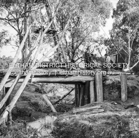
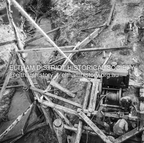
Negative - Photograph, J.A. McDonald, Pinnacle Lane, Steels Creek, Sep. 1955
... Pinnacle Lane, Steels Creek Negative Photograph J.A. McDonald ...The old bridge looking downstream Record of various Shire of Eltham infrastructure works undertaken during the period of 1952-1962 involving bridge and road reconstruction projects, sometimes with Eltham Shire Council Project Reference numbers quoted. It was during this period that a number of significant improvements were made to roads and new bridges constructed within the shire that remain in place as of present day (2022). In many situations, the photos provide a tangible visible record of infrastructure that existed throughout the early days of the Shire. The album was put together by or under the direction of the Shire Engineer, J.A. McDonald.1955-09, pinnacle lane, steels creek, bridge construction, infrastructure, shire of eltham -
 Eltham District Historical Society Inc
Negative - Photograph, J.A. McDonald, Pinnacle Lane, Steels Creek, Sep. 1955
... Pinnacle Lane, Steels Creek Negative Photograph J.A. McDonald ...The old bridge looking eastwardsRecord of various Shire of Eltham infrastructure works undertaken during the period of 1952-1962 involving bridge and road reconstruction projects, sometimes with Eltham Shire Council Project Reference numbers quoted. It was during this period that a number of significant improvements were made to roads and new bridges constructed within the shire that remain in place as of present day (2022). In many situations, the photos provide a tangible visible record of infrastructure that existed throughout the early days of the Shire. The album was put together by or under the direction of the Shire Engineer, J.A. McDonald.1955-09, pinnacle lane, steels creek, bridge construction, infrastructure, shire of eltham -
 Eltham District Historical Society Inc
Negative - Photograph, J.A. McDonald, Pinnacle Lane, Steels Creek, Sep. 1955
... Pinnacle Lane, Steels Creek Negative Photograph J.A. McDonald ...The old bridge from top of pile frameRecord of various Shire of Eltham infrastructure works undertaken during the period of 1952-1962 involving bridge and road reconstruction projects, sometimes with Eltham Shire Council Project Reference numbers quoted. It was during this period that a number of significant improvements were made to roads and new bridges constructed within the shire that remain in place as of present day (2022). In many situations, the photos provide a tangible visible record of infrastructure that existed throughout the early days of the Shire. The album was put together by or under the direction of the Shire Engineer, J.A. McDonald.1955-09, pinnacle lane, steels creek, bridge construction, infrastructure, shire of eltham -
 Eltham District Historical Society Inc
Negative - Photograph, J.A. McDonald, Inspection of storm damaged Abraham house at Kangaroo Ground, c. May 1962
... Lane). Record of various Shire of Eltham infrastructure works undertaken during the period of 1952-1962 involving bridge and road reconstruction projects, sometimes with Eltham Shire Council Project Reference numbers quoted. It was during this period that a number of significant improvements were made to roads and new bridges constructed within the shire that remain in place as of present day (2022). In many situations, the photos provide a tangible visible record of infrastructure that existed throughout the early days of the Shire. The album was put together by or under the direction of the Shire Engineer, J.A. McDonald ...Showing the effect of a wind storm that destroyed the house circa May 1962.. The Abraham family owned land near the Aqueduct and east of Nicholas Lane at Kangaroo Ground (based on photos, at or near 40 Nicholas Lane).Record of various Shire of Eltham infrastructure works undertaken during the period of 1952-1962 involving bridge and road reconstruction projects, sometimes with Eltham Shire Council Project Reference numbers quoted. It was during this period that a number of significant improvements were made to roads and new bridges constructed within the shire that remain in place as of present day (2022). In many situations, the photos provide a tangible visible record of infrastructure that existed throughout the early days of the Shire. The album was put together by or under the direction of the Shire Engineer, J.A. McDonald.1962-05, abraham house, kangaroo ground, nicholas lane, property damage, storm damage -
 Eltham District Historical Society Inc
Negative - Photograph, J.A. McDonald, Inspection of storm damaged Abraham house at Kangaroo Ground, c. May 1962
... Lane). Record of various Shire of Eltham infrastructure works undertaken during the period of 1952-1962 involving bridge and road reconstruction projects, sometimes with Eltham Shire Council Project Reference numbers quoted. It was during this period that a number of significant improvements were made to roads and new bridges constructed within the shire that remain in place as of present day (2022). In many situations, the photos provide a tangible visible record of infrastructure that existed throughout the early days of the Shire. The album was put together by or under the direction of the Shire Engineer, J.A. McDonald ...Showing the effect of a wind storm that destroyed the house circa May 1962.. The Abraham family owned land near the Aqueduct and east of Nicholas Lane at Kangaroo Ground (based on photos, at or near 40 Nicholas Lane).Record of various Shire of Eltham infrastructure works undertaken during the period of 1952-1962 involving bridge and road reconstruction projects, sometimes with Eltham Shire Council Project Reference numbers quoted. It was during this period that a number of significant improvements were made to roads and new bridges constructed within the shire that remain in place as of present day (2022). In many situations, the photos provide a tangible visible record of infrastructure that existed throughout the early days of the Shire. The album was put together by or under the direction of the Shire Engineer, J.A. McDonald.1962-05, abraham house, kangaroo ground, nicholas lane, property damage, storm damage, building surveyor, george e. newton -
 Eltham District Historical Society Inc
Negative - Photograph, J.A. McDonald, Inspection of storm damaged Abraham house at Kangaroo Ground, c. May 1962
... Lane). Record of various Shire of Eltham infrastructure works undertaken during the period of 1952-1962 involving bridge and road reconstruction projects, sometimes with Eltham Shire Council Project Reference numbers quoted. It was during this period that a number of significant improvements were made to roads and new bridges constructed within the shire that remain in place as of present day (2022). In many situations, the photos provide a tangible visible record of infrastructure that existed throughout the early days of the Shire. The album was put together by or under the direction of the Shire Engineer, J.A. McDonald ...Showing the effect of a wind storm that destroyed the house circa May 1962.. The Abraham family owned land near the Aqueduct and east of Nicholas Lane at Kangaroo Ground (based on photos, at or near 40 Nicholas Lane).Record of various Shire of Eltham infrastructure works undertaken during the period of 1952-1962 involving bridge and road reconstruction projects, sometimes with Eltham Shire Council Project Reference numbers quoted. It was during this period that a number of significant improvements were made to roads and new bridges constructed within the shire that remain in place as of present day (2022). In many situations, the photos provide a tangible visible record of infrastructure that existed throughout the early days of the Shire. The album was put together by or under the direction of the Shire Engineer, J.A. McDonald.1962-05, abraham house, kangaroo ground, nicholas lane, property damage, storm damage -
 Eltham District Historical Society Inc
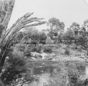
Photograph, Tom Prior, River Yarra
... The photographs are a reminder of the rural nature of Research and Eltham and its rich heritage. reynolds prior collection eltham yarra river Sweeneys Lane The Reynolds/Prior Photograph Collection, Presented to the Eltham District Historical Society, 14 June 2006 by Ross McDonald. ...Situated near Sweeney's Lane, the house in the picture was owned by the man who was Commissioner that looked after the Aboriginees - Ivy Reynolds. Labelled by Ivy Reynolds' mother who had a good sense of humour.The Reynolds family were early settlers in Research. The Reynolds/ Prior collection of photographs were taken by Tom Prior, the maternal uncle of Ivy Reynolds, around 1900 and the 60 photos in the album give a fine overview of many of the landmarks of Research and Eltham over 100 years ago. lvy lived in the family home for many years at 106 Thompson Cres Research. Ivy's father, Ernst Richard Reynolds and grandfather, Richard Reynolds, lived at the same address. Ivy's father Richard worked for Mr. Trail on his property in Research. Reynolds Road is named after the family. Mr Tom Prior (wife Eva) worked at the Melbourne zoo. He was very innovative and made his own camera, using the black cloth hood to exclude the light. The photographs are a reminder of the rural nature of Research and Eltham and its rich heritage. Black and white photograph mounted in an album, the Reynolds/Prior Photograph Collection, this being one of 53 reproduced black and white images of early Eltham.The Reynolds/Prior Photograph Collection, Presented to the Eltham District Historical Society, 14 June 2006 by Ross McDonald. A second copy was also presented to the Andrew Ross Museum, Kangaroo Groundreynolds prior collection, eltham, yarra river, sweeneys lane -
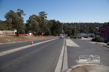
 Eltham District Historical Society Inc
Photograph, Peter Pidgeon, McDonalds Restaurant, cnr Bridge Street and Bolton Street, Eltham, during Bolton Street upgrade, 13 November, 2017, 13/11/2017
... Eltham District Historical Society Inc 728 Main Rd Eltham melbourne North bound lane closure Bolton Street bolton street upgrade eltham streets bridge street McDonalds Restaurant Born Digital McDonalds Restaurant, cnr Bridge Street and Bolton Street, Eltham, during Bolton Street upgrade, 13 November, 2017 Photograph Peter Pidgeon ...North bound lane closureBorn Digitalbolton street, bolton street upgrade, eltham, streets, bridge street, mcdonalds restaurant -
 Eltham District Historical Society Inc
Photograph, Peter Pidgeon, Bolton Street upgrade, Eltham, 13 November, 2017, 13/11/2017
... North bound lane closure, near Bridge Street, McDonalds on left. ...Eltham District Historical Society Inc 728 Main Rd Eltham melbourne North bound lane closure, near Bridge Street, McDonalds on left. bolton street bolton street upgrade eltham streets mcdonalds restaurant Born Digital Bolton Street upgrade, Eltham, 13 November, 2017 Photograph Peter Pidgeon ...North bound lane closure, near Bridge Street, McDonalds on left. Born Digitalbolton street, bolton street upgrade, eltham, streets, mcdonalds restaurant -
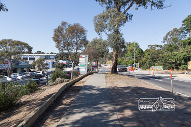
 Eltham District Historical Society Inc
Photograph, Peter Pidgeon, Bolton Street upgrade, Eltham, 13 November, 2017, 13/11/2017
... North bound lane closure, near Bridge Street, McDonalds on left. ...Eltham District Historical Society Inc 728 Main Rd Eltham melbourne North bound lane closure, near Bridge Street, McDonalds on left. bolton street bolton street upgrade eltham streets Middy's Born Digital Bolton Street upgrade, Eltham, 13 November, 2017 Photograph Peter Pidgeon ...North bound lane closure, near Bridge Street, McDonalds on left. Born Digitalbolton street, bolton street upgrade, eltham, streets, middy's -
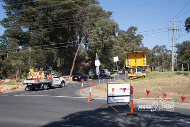 Eltham District Historical Society Inc
Photograph, Peter Pidgeon, Intersection with Grand Boulevard, Bolton Street upgrade, Eltham, 13 November, 2017, 13/11/2017
... North bound lane closure, near Bridge Street, McDonalds on left. ...Eltham District Historical Society Inc 728 Main Rd Eltham melbourne North bound lane closure, near Bridge Street, McDonalds on left. bolton street bolton street upgrade eltham streets Grand Boulevard Born Digital Intersection with Grand Boulevard, Bolton Street upgrade, Eltham, 13 November, 2017 Photograph Peter Pidgeon ...North bound lane closure, near Bridge Street, McDonalds on left. Born Digitalbolton street, bolton street upgrade, eltham, streets, grand boulevard -
 Eltham District Historical Society Inc
Photograph, Peter Pidgeon, Bolton Street upgrade, Eltham, 13 November, 2017, 13/11/2017
... North bound lane closure, near Bridge Street, McDonalds on left. ...Eltham District Historical Society Inc 728 Main Rd Eltham melbourne North bound lane closure, near Bridge Street, McDonalds on left. bolton street bolton street upgrade eltham streets Eltham Ridge Shops Born Digital Bolton Street upgrade, Eltham, 13 November, 2017 Photograph Peter Pidgeon ...North bound lane closure, near Bridge Street, McDonalds on left. Born Digitalbolton street, bolton street upgrade, eltham, streets, eltham ridge, shops