Showing 818 items matching "mcmillan"
-
 Linton and District Historical Society Inc
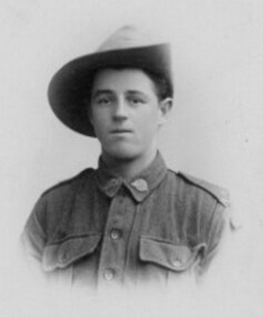
Photograph, A J Bealing and Son, Shaftsbury and Forant, Private Dave McMillan, 1916, 1916
... Private Dave McMillan, 1916...Black and white photo of Private Dave McMillan. An inscription on the back of the photograph says that it was taken at Christmas 1916...."Private Dave McMillan of Linton-Christmas 1916-called Tigger"....Linton and District Historical Society Inc 69 Sussex Street Linton 3360 goldfields Dave McMillan World War 1914-1918 "Private Dave McMillan of Linton-Christmas 1916-called Tigger". ...Black and white photo of Private Dave McMillan. An inscription on the back of the photograph says that it was taken at Christmas 1916."Private Dave McMillan of Linton-Christmas 1916-called Tigger".dave mcmillan, world war 1914-1918 -
 Lakes Entrance Historical Society
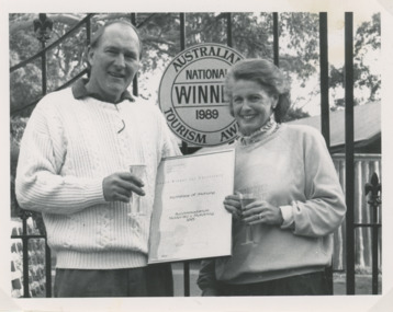
Photograph - John and Kaye McMillan, Lakes Post Newspaper, 1/07/1991 12:00:00 AM
... John and Kaye McMillan...John and Kaye McMillan of McMillan of Metung with their Tourist Award for accommodation Metung Victoria. ...Black and white photograph showing John and Kaye McMillan of McMillan of Metung with their Tourist Award for accommodation Metung Victoria. ...Lakes Entrance Historical Society 4 Marine Parade Lakes Entrance gippsland John and Kaye McMillan of McMillan of Metung with their Tourist Award for accommodation Metung Victoria. ...John and Kaye McMillan of McMillan of Metung with their Tourist Award for accommodation Metung Victoria. Also three more photographs of John and Kaye McMillan with further tourism awards 1992 1994 and 1995 numbers 04168.1, size 16 x 12 cm, number 04168.2 size 12.5 x 13 cm, 04168.3 size 16 x 19 cmBlack and white photograph showing John and Kaye McMillan of McMillan of Metung with their Tourist Award for accommodation Metung Victoria. Also three more photographs of John and Kaye McMillan with further tourism awards 1992 1994 and 1995 numbers 04168.1, size 16 x 12 cm, number 04168.2 size 12.5 x 13 cm, 04168.3 size 16 x 19 cm tourism, accommodation -
 Vision Australia
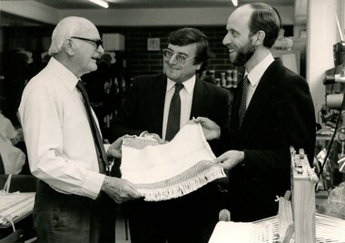
Photograph - Image, John Saunderson and Lindsay McMillan with unidentified man, 1984-90
... John Saunderson and Lindsay McMillan with unidentified man...John Saunderson, former Member for Aston, looks at a piece of weaving with Lindsay McMillan and an elderly man....Centre John Saunderson former Member for Auston and Linsday McMillan...John Saunderson, former Member for Aston, looks at a piece of weaving with Lindsay McMillan and an elderly man. Association for the Blind John Saunderson Lindsay McMillan Centre John Saunderson former Member for Auston and Linsday McMillan 1 black and white images of three men John Saunderson and Lindsay McMillan with unidentified man Photograph Image ...John Saunderson, former Member for Aston, looks at a piece of weaving with Lindsay McMillan and an elderly man.1 black and white images of three menCentre John Saunderson former Member for Auston and Linsday McMillanassociation for the blind, john saunderson, lindsay mcmillan -
 Glenelg Shire Council Cultural Collection
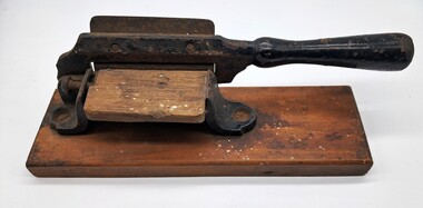
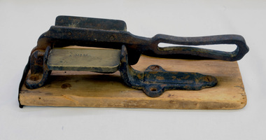
Functional object - Tobacco Cutter, McMillan, 1900-1940
... ...McMillan...McMillan...McMillan...Smoking Tobacco McMillan Portland Glenelg Shire Cigarette Pipe McMillan A timber and cast iron guillotine style tobacco cutter. ...This type of tobacco cutter was used to cut plugs of tobacco suitable for pipes. It was an important piece of equipment for smokers until ready made cigarettes became more widely available.Tobacco cutters were regularly in use before pre-made cigarettes became more readily available.A timber and cast iron guillotine style tobacco cutter. A rectangular timber base on which sites a cast iron stand and cutter. The cutter has a timber board (striking plate)for cutting the tobacco on. The wooden base has evidence of non-active bora. The striking plate for cutting seems to have the name of a manufacturer on it.McMillansmoking, tobacco, mcmillan, portland, glenelg shire, cigarette, pipe -
 Ballarat Heritage Services
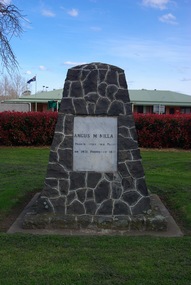
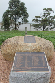
Photograph - Colour, Clare Gervasoni, Angus McMillan Cairn at Yarram, 2011, 28/08/2011
... Angus McMillan Cairn at Yarram, 2011...Photograph of the Angus McMillan cairn at Yarram....Ballarat Heritage Services PO Box 2209 Bakery Hill Post Office goldfields Yarram Angus MCMillan Photograph of the Angus McMillan cairn at Yarram. ...Photograph of the Angus McMillan cairn at Yarram.yarram, angus mcmillan -
 Orbost & District Historical Society
tobacco cutter, late 19th -early 20th century
... This McMillan Tobacco Cutter was used to cut plugs of tobacco suitable for pipes....Inscription "McMillan" appears on the striker plate....A. McMillan...McMillan ...This McMillan Tobacco Cutter was used to cut plugs of tobacco suitable for pipes.Tobacco cutters were important tools for pipe smokers until self-made or manufactured cigarettes began to dominate the tobacco sales market from the 1920s. This item is a link to a previously common means of consuming tobacco.Metal tobacco cutter (guillotine style), mounted on wooden base, with brass striker plate.Inscription "McMillan" appears on the striker plate.smoking tobacco-cutter -
 Lakes Entrance Historical Society
Book, White, Kelvin, Angus McMillan Memorial Cairn, Dargo Road, Iguana Creek, 2002
... Angus McMillan Memorial Cairn, Dargo Road, Iguana Creek....Research, interpretation and management recommendations for the Angus McMillan memorial cairn, Dargo Road, Iguana Creek, Gippsland, Victoria, by Forestec Student...Lakes Entrance Historical Society 4 Marine Parade Lakes Entrance gippsland Memorials Explorers Research, interpretation and management recommendations for the Angus McMillan memorial cairn, Dargo Road, Iguana Creek, Gippsland, Victoria, by Forestec Student Angus McMillan Memorial Cairn, Dargo Road, Iguana Creek. ...Research, interpretation and management recommendations for the Angus McMillan memorial cairn, Dargo Road, Iguana Creek, Gippsland, Victoria, by Forestec Studentmemorials, explorers -
 Stawell Historical Society Inc
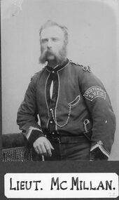
Photograph, Stawell Fire Brigade's Lieut McMillan 1885 -- Studio Portrait
... Stawell Fire Brigade's Lieut McMillan 1885 -- Studio Portrait...Portrait. Lieut. McMillan. Stawell Fire Brigade 1885...Stawell Historical Society Inc 46 Longfield St Stawell grampians Portrait. Lieut. McMillan. Stawell Fire Brigade 1885 Stawell Stawell Fire Brigade's Lieut McMillan 1885 -- Studio Portrait Photograph ...Portrait. Lieut. McMillan. Stawell Fire Brigade 1885stawell -
 Greensborough Historical Society
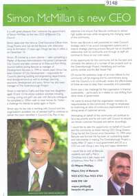
Article - Article, Newsletter, Simon McMillan is new CEO, 2007
... Simon McMillan is new CEO...Article by Wayne Phillips introducing Simon McMillan the new CEO of City of Banyule...Greensborough Historical Society 34A Glenauburn Road Lower Plenty Lower Plenty melbourne Article by Wayne Phillips introducing Simon McMillan the new CEO of City of Banyule Banyule City Council wayne phillips simon mcmillan Text with good colour image Simon McMillan is new CEO Article Article, Newsletter ...Article by Wayne Phillips introducing Simon McMillan the new CEO of City of BanyuleText with good colour imagebanyule city council, wayne phillips, simon mcmillan -
 Greensborough Historical Society
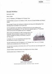
Article, Greensborough Historical Society et al, Donald McMillan, 1914-1918
... Donald McMillan...A short article about Donald McMillan` and his service in World War 1. He was born in St Helena....Greensborough Historical Society 34A Glenauburn Road Lower Plenty Lower Plenty melbourne A short article about Donald McMillan` and his service in World War 1. He was born in St Helena. world war 1 project donald mcmillan One page, text and colour images. ...A short article about Donald McMillan` and his service in World War 1. He was born in St Helena.One page, text and colour images.world war 1 project, donald mcmillan -
 Kew Historical Society Inc
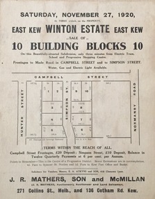
Plan - Subdivision Plan, Winton Estate, East Kew : Sale of 10 Building Blocks, 1920
... These early plans were assembled by a local firm, Jas R Mather & McMillan, which had an office in Cotham Road. ...Mathers, Son and McMillan. ...Jas R Mathers Son & McMillan...Mathers, Son and McMillan. Winton Estate, East Kew : Sale of 10 Building Blocks Plan Subdivision Plan Jas R Mathers Son & McMillan ...The Kew Historical Society's map collection includes a substantial number of real estate subdivision plans, mainly of Kew but also of surrounding suburbs in Melbourne. Most of the subdivision plans date from the 1920s and 1930s when the districts old homes and local farmland were being split up to accommodate residential growth in the postwar period. These early plans were assembled by a local firm, Jas R Mather & McMillan, which had an office in Cotham Road. Many of the plans, and sometimes photos, were annotated by the agents.Subdivision plans are historically important documents used as evidence for the growth of suburbs in Australia. They frequently provide information about when the land was sold as well as evidence relating to surveyors and real estate and financial agents. The numerous subdivision plans in the Kew Historical Society's collection represent working documents, ranging from the initial sketches made in planning a subdivision to printed plans on which auctioneers or agents listed the prices for which individual lots were sold. In a number of cases, the reverse of a subdivision plan in the collection includes a photograph of a house that was also for sale by the agent. These photographs provide significant heritage information relating house design and decoration, fencing and household gardens.The photograph may also be aesthetically significant depending on the importance of the photographic atelier.Subdivision plan for the so-called Winton Estate in East Kew. The Estate comprised 10 lots facing Simpson Street and Campbell Street. The estate was auctioned by Jas. R. Mathers, Son and McMillan. campbell street, simpson street, hunter street, normanby road - kew, subdivision plans - east kew, subdivision plans - kew -
 Lakes Entrance Historical Society
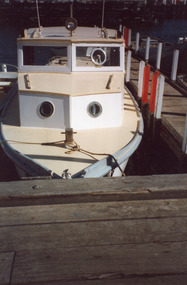
Photograph - McMillan, 2001
... McMillan...Bow view of the McMillan - formerly known as Paddy McCann. Lakes Entrance Victoria...Bow view of the McMillan - formerly known as Paddy McCann. Lakes Entrance Victoria Photograph McMillan ...Date made 1 November 2001Colour photograph showing former Public Works Department boat at Ports jetty on Bullock Island. Bow view of the McMillan - formerly known as Paddy McCann. Lakes Entrance Victoriaislands, jetties, boats and boating -
 Orbost & District Historical Society
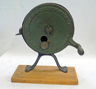
knife cleaner / sharpener, first half 20th century
... A McMillan Federal Knife Cleaner...A. McMillan...It has a wooden turning handle. knife cleaner / sharpener A. McMillan ...Sharpening is done by grinding away material on this implement with an abrasive substance harder than the material of the tool to be sharpened. A sharpening wheel is an efficient way to sharpen blade edges.Mobile knife-sharpening services are no longer commonly used. In the disposable society of the 21st century we can throw away our blunt scissors, knives or tools and buy replacements.A cast iron knife or tool sharpening wheel attach to a wooden base. It has a wooden turning handle.A McMillan Federal Knife Cleanerknife-grinder -
 Uniting Church Archives - Synod of Victoria
BW photo, 1974
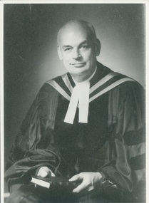
... Dr McMillan was from Canada to deliver the inaugural Olivier Beguin Memorial Lecture in Canberra, June 10, 1974. ...Portrait of Rev. Dr Kenneth McMillan, seated, dressed in full clerical dress....Rev Dr Kenneth McMillan, New Spectator, May 22, 1974, p. 9...Dr McMillan was from Canada to deliver the inaugural Olivier Beguin Memorial Lecture in Canberra, June 10, 1974. ...Dr McMillan was from Canada to deliver the inaugural Olivier Beguin Memorial Lecture in Canberra, June 10, 1974. He was General Secretary of the Bible Society in Canada, a minister of the Presbyterian Church of Canada, and was a past Moderator. Olivier Beguin was a Swiss teacher who as general secretary of the United Bible Societies for nearly 25 years.Portrait of Rev. Dr Kenneth McMillan, seated, dressed in full clerical dress.Rev Dr Kenneth McMillan, New Spectator, May 22, 1974, p. 9mcmillan, dr keneth; canada bible society; olivier beguin memorial lecture -
University of Melbourne, Burnley Campus Archives
Document - Photocopy, I. S. McMillan, Proposed course - opportunities in Agriculture and Horticulture, 1964
... Memorandum from I S McMillan. Photocopy of handwritten notes...I. S. McMillan...S. McMillan ...Memorandum from I S McMillan. Photocopy of handwritten notesi. s. mcmillan -
University of Melbourne, Burnley Campus Archives
Booklet - Handbook, Rod McMillan, A Student Handbook for Further Study of Soils and Growing Media, 1993
... Display copy (Bookshop) for the Advanced Certificate in Horticulture by Rod McMillan......Rod McMillan...University of Melbourne, Burnley Campus Archives 500 Yarra Boulevard Richmond melbourne horticulture soil media rod mcmillan Display copy (Bookshop) for the Advanced Certificate in Horticulture by Rod McMillan A Student Handbook for Further Study of Soils and Growing Media Booklet Handbook Found Rod McMillan ...horticulture, soil, media, rod mcmillan -
University of Melbourne, Burnley Campus Archives
Booklet, Michele Adler, Studies in Horticulture, 1998-2007
... Series editors: Rod McMillan and Michele Adler. Spiral bound with plastic covers. 1. ......Rod McMillan...'Workplace communication and communicate in the Workplace,' by Rod McMillan. 1999. 9. 'Soil characteristics,' by Rod McMillan. 1998. 10. ...Royalties from the sale of booklets donated to the Friends of Burnley GardensPlants in Print price labels on some of them. Display Copy Not for Sale on some of them.studies in horticulture, horticulture, t.a.f.e., rod mcmillan, michele adler, plant recognition, workplace requirements, industry requirements, workplace communication, peter esdale, workplace maintenance, peter sheppard, teamwork, soil characteristics, lanscape drawing, graphics, ken wallace, scott watson, ron barrow, operate tractors, operate machinery, ken james, work environment, john stanley, promotional program, oh & s procedures -
 Kew Historical Society Inc
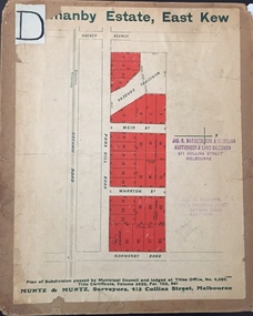
Plan - Subdivision Plan, J R Mathers & McMillan, Normanby Estate, c.1913
... These early plans were assembled by a local firm, Jas R Mather & McMillan, which had an office in Cotham Road. ...Mathers & Son & McMillan / Auctioneer & Land Salesmen, / 271 Collins Street / Melbourne" and Jas. ...J R Mathers & McMillan...Normanby Estate Plan Subdivision Plan J R Mathers & McMillan ...The Kew Historical Society's map collection includes a substantial number of real estate subdivision plans, mainly of Kew but also of surrounding suburbs in Melbourne. Most of the subdivision plans date from the 1920s and 1930s when the districts old homes and local farmland were being split up to accommodate residential growth in the postwar period. These early plans were assembled by a local firm, Jas R Mather & McMillan, which had an office in Cotham Road. Many of the plans, and sometimes photos, were annotated by the agents.Subdivision plans are historically important documents used as evidence for the growth of suburbs in Australia. They frequently provide information about when the land was sold as well as evidence relating to surveyors and real estate and financial agents. The numerous subdivision plans in the Kew Historical Society's collection represent working documents, ranging from the initial sketches made in planning a subdivision to printed plans on which auctioneers or agents listed the prices for which individual lots were sold. In a number of cases, the reverse of a subdivision plan in the collection includes a photograph of a house that was also for sale by the agent. These photographs provide significant heritage information relating house design and decoration, fencing and household gardens.The photograph may also be aesthetically significant depending on the importance of the photographic atelier.The Normanby Estate, which was adjacent to Normanby Road, Kew East, included thirty-one lots for sale. Streets on the subdivision plan include Adeney Avenue, Park Hill Road, Normanby Road, Weir Street and Wharton Street. Cotham Road and its tramway are shown nearby. The plan is interesting as it shows Wharton Street, named after the architect and town planner George Wharton, who was the first chairman of the Municipality of Kew. The street was to later be renamed Cecil Street. Also shown are proposed ‘Municipal Gardens’ where Parkhill Drive is now located."D" in top left corner. Stamped auctioneers contact details: "Jas. R. Mathers & Son & McMillan / Auctioneer & Land Salesmen, / 271 Collins Street / Melbourne" and Jas. R. Mathers / Estate & Financial Agent / Cotham Road / Kew".weir street - kew, wharton street - kew, normanby road - kew, cotham road - kew, municipal gardens - kew, park hill parkhill road - kew, braemar - kew, subdivision plans - kew -
University of Melbourne, Burnley Campus Archives
Document, Adland Horticultural Australia et al, Advanced Certificate of Horticulture, c. 1990-2004
... Documents used in the the Correspondence course run through McMillan Campus. 1. Chapters 1-3 of the subject Plants and their environment. 2. ......Rod McMillan...University of Melbourne, Burnley Campus Archives 500 Yarra Boulevard Richmond melbourne correspondence course mcmillan campus plants plant lists horticulture descriptions of plants Documents used in the the Correspondence course run through McMillan Campus. 1. ...correspondence course, mcmillan campus, plants, plant lists, horticulture, descriptions of plants -
University of Melbourne, Burnley Campus Archives
Document - Plant List, Michele Adler et al, Studies in Horticulture Plant Photographs - Autumn
... Compiled by Michèle Adler and Rod McMillan......Rod McMillan...Compiled by Michèle Adler and Rod McMillan Studies in Horticulture Plant Photographs - Autumn Document Plant List Michele Adler Rod McMillan The University of Melbourne ...michele adler, rod mcmillan, studies in horticulture, plant lists, photographs of plants -
 Glen Eira Historical Society
Document - McMillan Street, 14, Elsternwick
... Photographs and Document about this property: 2 small, black and white photographs of a two storey brick house at 14 McMillan Street, Elsternwick. Document – research notes by Joan Moore from Sands and McDougall’s Directory of Victoria 1911 and 1923....14 McMillan Street, Elsternwick, Victoria, Australia...McMillan Street Elsternwick Mansions Brick Houses Flats Bell J. ...Photographs and Document about this property: 2 small, black and white photographs of a two storey brick house at 14 McMillan Street, Elsternwick. Document – research notes by Joan Moore from Sands and McDougall’s Directory of Victoria 1911 and 1923.mcmillan street, elsternwick, mansions, brick houses, flats, bell j. mrs, jones ernest, agg cyril, noel anthony, apartments, sherbrooke, sherbrooke flats -
 Bendigo Military Museum
Award - MEDAL SET WW1, Post 1919
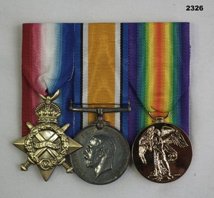
... Jack McMillan (born Wandong Vic, enlisted Blackboy Hill WA) No 319 enlisted in D Coy 16th Batt AIF on 22.9.14 aged 20 years 2 months. ...Medals, court mounted, set of (3) re J McMillan. 1. 1914-15 Star, replica not engraved. 2. ..."319 L/Cpl J McMillan 16 BN A.I.F"...Medals military ron mills collection "319 L/Cpl J McMillan 16 BN A.I.F" Medals, court mounted, set of (3) re J McMillan. 1. 1914-15 Star, replica not engraved. 2. ...Jack McMillan (born Wandong Vic, enlisted Blackboy Hill WA) No 319 enlisted in D Coy 16th Batt AIF on 22.9.14 aged 20 years 2 months. Embarked for Eygpt 22.12.14, embarked for Gallipoli 12.4.15, Sprained ankle, classed as WIA on 27.4.15, embarked again for Gallipoli 8.6.15, hospital 21.7.15 with Diarrhoea, WIA 2nd occasion 8.8.15 GSW right hand turned Septic, hospital 11.4.16 with Pyorrhoea. Embarked for France 7.6.16, WIA 3rd occasion 10.8.16 GSW right thigh, WIA 4th occasion 5.2.17 shell wound to Forehead, hospital France with scalded right foot 30.5.17 then contracts Scabies 2.6.17, Boils on 28.7.17. While in England he goes AWL 3 times, embarks for France 8.5.18, goes AWL twice more, appointed L/ Cpl 2.9.18, discharged from the AIF on 13.1.19.Medals, court mounted, set of (3) re J McMillan. 1. 1914-15 Star, replica not engraved. 2. War Medal 1914-18 2. Victory Medal 1914 - 1919, replica not engraved."319 L/Cpl J McMillan 16 BN A.I.F"medals, military, ron mills collection -
University of Melbourne, Burnley Campus Archives
Newsletter - Folder of Newsletters, VCAH McMillan, Estafette Distance Learning Centre, May 1987-1993
... Large 4-ring folder containing pages of the official Newsletter of the VCAH Distance Learning Centre located at McMillan Campus, Warragul. Vol. 1 No. 1 May 1987 to Vol. 7 No. 2 1993 and Guide Sheets Nos. 1-19....VCAH McMillan...University of Melbourne, Burnley Campus Archives 500 Yarra Boulevard Richmond melbourne vcah Victorian College of Agriculture and Horticulture distance learning mcmillan campus Large 4-ring folder containing pages of the official Newsletter of the VCAH Distance Learning Centre located at McMillan Campus, Warragul. ...vcah, victorian college of agriculture and horticulture, distance learning, mcmillan campus -
 Kew Historical Society Inc
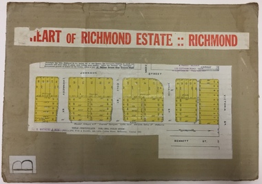
Plan - Subdivision Plan, J R Mathers & McMillan, Heart of Richmond Estate : Richmond, 1928
... Title Certificate Vol.2381, Folio 476130 Phillips, Fox & Masel, 440 Little Collins Street, Melbourne (Local estate agent: Jas. R. Mathers & McMIllan, 136 Cotham Road, Kew)...J R Mathers & McMillan...Area includes Johnson Street, Victoria Street, Kennedy Street, Cole Street, Hollick Street, Bennett Street Heart of Richmond Estate : Richmond Plan Subdivision Plan J R Mathers & McMillan ..."In 1928 the land on the east side of Johnson Street was subdivided in 60 lots for the ‘Heart of Richmond Estate’. The houses in the subdivision, along the east side of Johnson Street, and in the newly created Hollick, Cole and Kennedy streets were constructed from 1928 to 1937." (Source: City of Yarra Heritage Gaps Review One 2013)Portion of subdivision plan pasted on to cardboard. Area includes Johnson Street, Victoria Street, Kennedy Street, Cole Street, Hollick Street, Bennett StreetTitle Certificate Vol.2381, Folio 476130 Phillips, Fox & Masel, 440 Little Collins Street, Melbourne (Local estate agent: Jas. R. Mathers & McMIllan, 136 Cotham Road, Kew)subdivision plans - richmond (vic.), heart of richmond estate -
 Narre Warren and District Family History Group
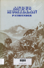
Book, Kenneth Cox, Angus McMillan : pathfinder, 1973
... Angus McMillan : pathfinder...Cattle mustering. Angus McMillan : pathfinder Book Kenneth Cox Olinda Public Relations ...McMillan appointed Protector of Aborigines, Port Albert area. Cattle mustering.non-fictionMcMillan appointed Protector of Aborigines, Port Albert area. Cattle mustering.life on the isle of skye, ewen mcleod, dargo, monaro district nsw, iguana creek -
 Inverloch Historical Society
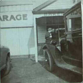
000551 - Photograph - McMillan Garage, Bakery - Chev - C Newton
... 000551 - Photograph - McMillan Garage, Bakery - Chev - C Newton...Inverloch gippsland 000551 - Photograph - McMillan Garage, Bakery - Chev - C Newton ... -
Lakes Entrance Historical Society
Book, Angus McMillan Pathfinder
... Angus McMillan Pathfinder...Lakes Entrance Historical Society 4 Marine Parade Lakes Entrance gippsland Exploration Angus McMillan Pathfinder Book ...exploration -
University of Melbourne, Burnley Campus Archives
Booklet, McMillan Campus, Victorian College of Agriculture and Horticulture, 1984-91
... McMillan Campus, Victorian College of Agriculture and Horticulture...University of Melbourne, Burnley Campus Archives 500 Yarra Boulevard Richmond melbourne mcmillan campus agriculture horticulture victoria Handbooks 1986, 1987; Campus Profile 1985; Annual Report 1984; Short Courses 1991, 5 booklets McMillan Campus, Victorian College of Agriculture and Horticulture Booklet ...Handbooks 1986, 1987; Campus Profile 1985; Annual Report 1984; Short Courses 1991, 5 bookletsmcmillan campus, agriculture, horticulture, victoria -
University of Melbourne, Burnley Campus Archives
Document, McMillan Rural Studies Centre, 1977-1980
... McMillan Rural Studies Centre...University of Melbourne, Burnley Campus Archives 500 Yarra Boulevard Richmond melbourne annual report minutes mcmillan rural studies centre Annual Reports, minutes, Newsletters McMillan Rural Studies Centre Document ...Annual Reports, minutes, Newslettersannual report, minutes, mcmillan rural studies centre -
 Ballarat Heritage Services
Photograph - Photograph - Colour, Hazelwood Estate (McMillan Selection), 2017
... Hazelwood Estate (McMillan Selection)...Hazelwood Estate (McMillan Selection) Photograph Photograph - Colour ...Colour photograph of a list of names in metal onto a stone. hazelwood, mcmillan selection, hazelwood estate