Showing 310 items matching "melbourne metropolitan area"
-
 Sunshine and District Historical Society Incorporated
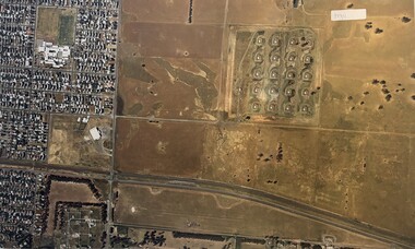
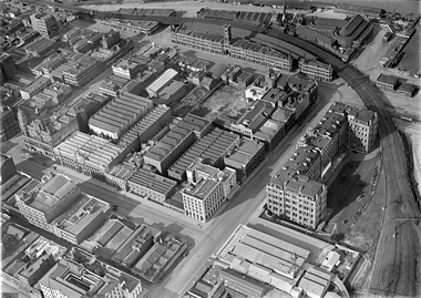
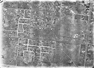
Photograph - Aerial Photographs Of Melbourne Metropolitan Area 1989, Qascophoto, 17th November 1989 & 28th November 1989
... Aerial Photographs Of Melbourne Metropolitan Area 1989...McKay Trade Wing, Tottenham Hotel, Sunshine Carvan Park 953.14 - Aerial Photographs Of Melbourne Metropolitan Area 1989.JPG Suburb(s): Derrimut, Mt. ...McKay Trade Wing, Tottenham Hotel, Sunshine Carvan Park 953.14 - Aerial Photographs Of Melbourne Metropolitan Area 1989.JPG Suburb(s): Derrimut, Mt. ...953.01 - Aerial Photographs Of Melbourne Metropolitan Area 1989.JPG Suburb(s): Ardeer, Deer Park (Now Derrimut), Sunshine West Area bounded by: Railway Parade (North), Paramount Bouvard (South), Allison Street (East), Approx Station Road (West) Points of Interest: IVI Explosive Bunkers, Railway Siding into ICI off Forrest Street, Former Railway Station Tilburn Road, Sunshine Technical School Annex, Croatian Catholic Centre Sunshine Fitzgerald Road 953.02 - Aerial Photographs Of Melbourne Metropolitan Area 1989.JPG Suburb(s): Brooklyn, Yarraville Area bounded by: South of Somerville Road (North), Westgate Freeway (South), Urwin Street (East). West of McDonald Road (West) Points of Interest: State Electricity Commission of Victoria (SECV) Stores, Brooklyn Wool Stores, Brooklyn Primary School, Half Moon Caravan Park, Footscray Cemetery, Rheems, James Hardy 953.03 - Aerial Photographs Of Melbourne Metropolitan Area 1989.JPG Suburb(s): Ascot Vale, Maribyrnong Area bounded by: Raleigh Road (North), River Street and James Street (South), Holdsworth Street (East), West of Van Ness Avenue (West) Points of Interest: Highpoint City, Fairbairn Park, Hume Pipes, Riverside Golf Course, ICI Laboratories 953.04 - Aerial Photographs Of Melbourne Metropolitan Area 1989.JPG Suburb(s): Albion, Ardeer, Sunshine, Sunshine West Area bounded by: Dubbo Street (North), South of Glengala Road (South), West of Sydney Street (East), Vernon Crescent (West) Points of Interest: Ainsworth Reserve, Selwyn Park, St. Paul Church, Marian College, Ardeer Primary School, Glengala Road Shopping Centre, 953.05 - Aerial Photographs Of Melbourne Metropolitan Area 1989.JPG Suburb(s): Deer Park Area bounded by: Station Road (East), Marcellin Court (West), Irvine Street (North), Deer Street (South) Points of Interest: Deer Park Primary School, Deer Park Play Kindergaten, Deer Park Shopping Centre, St. Peter Chanel Church & School 953.06 - Aerial Photographs Of Melbourne Metropolitan Area 1989.JPG Suburb(s): Derrimut Area bounded by: Future Ring Road (North), South of Boundary Road (South), East of Andersons Swamp (East), West of Fitzgerald Road (West) Points of Interest: Andersons Swamp 953.07 - Aerial Photographs Of Melbourne Metropolitan Area 1989.JPG Suburb(s): Sunshine West Area bounded by: East of Fairbairn Road (East), East of Fitzgerald Road (West), North of Mailey Street (North), South of Talintyre Road (South) Points of Interest: Sunshine West High School, Sunshine Heights Primary School, Castley Reserve, Talintyre Reserve, Talintyre Road Shops, St. Peters School, Sunshine Golf Course, Ralph Reserve, Glengala Primary School 953.08 - Aerial Photographs Of Melbourne Metropolitan Area 1989.JPG Suburb(s): Derrimut, Ravenhall Area bounded by: East of Station Road, now Derrimut Road (East), West of Robinsons Road (West), South of Railway Line (North), North of Future Deer Park Bypass Points of Interest: Old Farms and Quarries 953.09 - Aerial Photographs Of Melbourne Metropolitan Area 1989.JPG Suburb(s): Sydenham, Taylors Lakes, Taylors Hill Area bounded by: Taylors Creek (North), Future Hume Drive (South), West of Future Parmelia Drive (East), Future Hawthorn Grove (West) Points of Interest: Sydenham Reservoir, Sydenham Railway Station, Sydenham Memorial Hall, Sydenham Primary School, Sydenham Recreation Reserve, Catholic Regional College Sydenham, Kingdom Hall of Jehovah's Witnesses 953.10 - Aerial Photographs Of Melbourne Metropolitan Area 1989.JPG Suburb(s): Brooklyn, Tottenham Area bounded by: Stony Creek (North), South of Somerville Road (South), Holmwood Road (East), West of McDonald Road (West) Points of Interest: Monsanto, Dalgety's, Wool Stores, Sims Metals, Farmer & Graziers, Olex Cables, Redbrook Carpets, May & Baker, Cargil Oil, Smorgans 953.11 - Aerial Photographs Of Melbourne Metropolitan Area 1989.JPG Suburb(s): Brooklyn Area bounded by: South of Fourth Avenue (North), South of Bunting Road (South), West of McDonald Road, East of Fitzgerald Road (West) Points of Interest: Market Road, Bunting & Jones Road Quarries, Monsanto, ANI, Market Timber 953.12 - Aerial Photographs Of Melbourne Metropolitan Area 1989.JPG Suburb(s): Brooklyn, Laverton North Area bounded by: South of Bunting Road (North), Buchanan Road (South), Cypress Avenue (East). Little Boundary Road (West) Points of Interest: Jones Road and Old Geelong Road Quarries, Brooklyn Go Kart Track, Sims Metal Foundry, Ralphs, Guiding Star Hotel, Gas & Fuel Substation 953.13 - Aerial Photographs Of Melbourne Metropolitan Area 1989.JPG Suburb(s): Sunshine, Sunshine West Area bounded by: Parsons Street (North), South of Fourth Avenue (South), Alfred Street (East), West of Kororoit Creek (West) Points of Interest: Parsons Reserve, Wheat Silos, H.V. McKay Trade Wing, Tottenham Hotel, Sunshine Carvan Park 953.14 - Aerial Photographs Of Melbourne Metropolitan Area 1989.JPG Suburb(s): Derrimut, Mt. Derrimut, Sunshine West, Area bounded by: East of Allison Street (East), Mt. Derrimut (West), Hilma Street (North), South of old Sunshine Golf Course (South) Points of Interest: Mt. Derrimut, Sunshine Golf Course 953.15 - Aerial Photographs Of Melbourne Metropolitan Area 1989.jpeg Suburb(s): Avondale Height, Braybrook, Sunshine North Area bounded by: Canning Street (North), North of Cranwell Street (South), Medway Golf Course (East), Nottingham Street (West) Points of Interest: Duke Street Quarries, Cranwell Park, Pennell Reserve 953.16 - Aerial Photographs Of Melbourne Metropolitan Area 1989.jpeg Suburb(s): All of City of Sunshine Area bounded by: Maribyrnong River (North), Westgate Freeway (South), Nicholson Street (East), Robinsons Road (West) Points of Interest: General overall of the City of Sunshine 953.17 - Aerial Photographs Of Melbourne Metropolitan Area 1989.jpeg Map is missing 953.18 - Aerial Photographs Of Melbourne Metropolitan Area 1989.jpeg Suburb(s): Braybrook, Maidstone, Sunshine Area bounded by: Ballarat Road (North), North of South Road (South), East of Ashley Street (East), West of Duke Street (West) Points of Interest: Skinner Reserve, Kinder Smith Reserve, Churchill Avenue Shops, St. John College, Industrial Engineering, Invita Carpets, Tottenham Technical School, Carolone Chisholm College, Christ The King Primary School, Sunshine East Primary School, Dyecraft 953.19 - Aerial Photographs Of Melbourne Metropolitan Area 1989.JPG Suburb(s): Laverton North, Sunshine West Area bounded by: North of Boundary Road (North), Sewer Out Fall (South), East of Little Boundary Road (East), East of Future Ring Road (West). Points of Interest: Factories in Laverton Northmelbourne, aerial photograph -
 Ringwood and District Historical Society
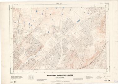
Map - Melbourne Metropolitan Area Base Map Series, Sheet 215 - Ringwood area, 1967
... Melbourne Metropolitan Area Base Map Series...Melbourne. Map prepared by Dept of Lands and Survey and MMBW from State Aerial Survey June 1957 and Cadastral Survey information July 1967. This sheet comprises parts of Municipalities of Doncaster & Templestowe, Nunawading and Ringwood, and Parishes of Nunawading and Warrandyte. Sheet 215 - Ringwood area, 1967 Map Melbourne Metropolitan ...Map prepared by Dept of Lands and Survey and MMBW from State Aerial Survey June 1957 and Cadastral Survey information July 1967. This sheet comprises parts of Municipalities of Doncaster & Templestowe, Nunawading and Ringwood, and Parishes of Nunawading and Warrandyte.Scale: 400 feet to 1 inch. Contours at 5 feet vertical interval. By Authority: A.C. Brooks, Commonwealth Printer, Melbourne. -
 Ringwood and District Historical Society
Map - Melbourne Metropolitan Area Base Map Series, Sheet 216 - Ringwood area, 1967
... Melbourne Metropolitan Area Base Map Series...Melbourne. Map prepared by Dept of Lands and Survey and MMBW from State Aerial Survey June 1957 and Cadastral Survey information July 1967. This sheet comprises parts of Municipalities of Croydon, Doncaster & Templestowe, and Ringwood, and Parishes of Ringwood and Warrandyte. Sheet 216 - Ringwood area, 1967 Map Melbourne Metropolitan ...Map prepared by Dept of Lands and Survey and MMBW from State Aerial Survey June 1957 and Cadastral Survey information July 1967. This sheet comprises parts of Municipalities of Croydon, Doncaster & Templestowe, and Ringwood, and Parishes of Ringwood and Warrandyte.Scale: 400 feet to 1 inch. Contours at 5 feet vertical interval. By Authority: A.C. Brooks, Commonwealth Printer, Melbourne. -
 Ringwood and District Historical Society
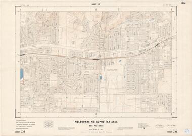
Map - Melbourne Metropolitan Area Base Map Series, Sheet 235 - Ringwood area, 1960
... Melbourne Metropolitan Area Base Map Series...Melbourne. Map prepared by Dept of Lands and Survey and MMBW from State Aerial Survey June 1957 and Cadastral Survey information August 1960. This sheet comprises parts of Municipalities of Doncaster & Templestowe, Nunawading and Ringwood, and Parishes of Nunawading, Ringwood and Warrandyte. Sheet 235 - Ringwood area, 1960 Map Melbourne Metropolitan ...Map prepared by Dept of Lands and Survey and MMBW from State Aerial Survey June 1957 and Cadastral Survey information August 1960. This sheet comprises parts of Municipalities of Doncaster & Templestowe, Nunawading and Ringwood, and Parishes of Nunawading, Ringwood and Warrandyte.Scale: 400 feet to 1 inch. Contours at 5 feet vertical interval. By Authority: A.C. Brooks, Commonwealth Printer, Melbourne. -
 Ringwood and District Historical Society
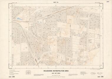
Map - Melbourne Metropolitan Area Base Map Series, Sheet 236 - Ringwood area, 1961
... Melbourne Metropolitan Area Base Map Series...Melbourne. Map prepared by Dept of Lands and Survey and MMBW from State Aerial Survey June 1957 and Cadastral Survey information May 1961. This sheet comprises parts of the Municipalities of Croydon and Ringwood, and Parishes of Ringwood and Warrandyte. Sheet 236 - Ringwood area, 1961 Map Melbourne Metropolitan ...Map prepared by Dept of Lands and Survey and MMBW from State Aerial Survey June 1957 and Cadastral Survey information May 1961. This sheet comprises parts of the Municipalities of Croydon and Ringwood, and Parishes of Ringwood and Warrandyte.Scale: 400 feet to 1 inch. Contours at 5 feet vertical interval. By Authority: A.C. Brooks, Commonwealth Printer, Melbourne. -
 Ringwood and District Historical Society
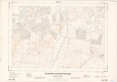
Map - Melbourne Metropolitan Area Base Map Series, Sheet 255 - Ringwood area, 1963
... Melbourne Metropolitan Area Base Map Series...Melbourne. Map prepared by Dept of Lands and Survey and MMBW from State Aerial Survey December 1956 and Cadastral Survey information May 1963. This sheet comprises parts of the Municipalities of Ferntree Gully, Nunawading and Ringwood, and Parishes of Nunawading, Ringwood and Scoresby. Sheet 255 - Ringwood area, 1963 Map Melbourne Metropolitan ...Map prepared by Dept of Lands and Survey and MMBW from State Aerial Survey December 1956 and Cadastral Survey information May 1963. This sheet comprises parts of the Municipalities of Ferntree Gully, Nunawading and Ringwood, and Parishes of Nunawading, Ringwood and Scoresby.Scale: 400 feet to 1 inch. Contours at 5 feet vertical interval. By Authority: A.C. Brooks, Commonwealth Printer, Melbourne. -
 Ringwood and District Historical Society
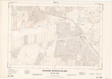
Map - Melbourne Metropolitan Area Base Map Series, Sheet 256 - Ringwood area, 1962
... Melbourne Metropolitan Area Base Map Series...Melbourne. Map prepared by Dept of Lands and Survey and MMBW from State Aerial Survey December 1956 and Cadastral Survey information December 1962. This sheet comprises parts of the Municipalities of Croydon, Ferntree Gully, and Ringwood, and Parishes of Ringwood and Scoresby. Sheet 256 - Ringwood area, 1962 Map Melbourne Metropolitan ...Map prepared by Dept of Lands and Survey and MMBW from State Aerial Survey December 1956 and Cadastral Survey information December 1962. This sheet comprises parts of the Municipalities of Croydon, Ferntree Gully, and Ringwood, and Parishes of Ringwood and Scoresby.Scale: 400 feet to 1 inch. Contours at 5 feet vertical interval. By Authority: A.C. Brooks, Commonwealth Printer, Melbourne. -
 Whitehorse Historical Society Inc.
Map, Melbourne Metropolitan Area Base Map, 1957?
... Melbourne Metropolitan Area Base Map...Scale: 400 ft = 1 inch Melbourne Metropolitan Area Base Map Map Map ...Sheet 254 of part of the Municipality of Nunawading and part of the Parish of Nunawading, showing roads, block numbers, creeks and contours mostly south of Canterbury Road.Sheet 254 of part of the Municipality of Nunawading and part of the Parish of Nunawading, showing roads, block numbers, creeks and contours mostly south of Canterbury Road. Prep. from State Aerial and Cadastral survey information, August 1957. Scale: 400 ft = 1 inchSheet 254 of part of the Municipality of Nunawading and part of the Parish of Nunawading, showing roads, block numbers, creeks and contours mostly south of Canterbury Road. city of nunawading, cadastral -
Whitehorse Historical Society Inc.
Map, Melbourne Metropolitan Area Base Map series. Sheet 214, c1960
... Melbourne Metropolitan Area Base Map series. Sheet 214...Note on map: 'prepared ... from State Aerial Survey, January 1957 and Cadastral Survey information February 1959'. Melbourne Metropolitan Area Base Map series. Sheet 214 Map Map ...Map showing northern section of the City of Nunawading together with parts of Shire of Doncaster and Templestowe.Map showing northern section of the City of Nunawading together with parts of Shire of Doncaster and Templestowe. Shows roads, creeks, block numbers and contours at 5 feet vertical increments. Note on map: 'prepared ... from State Aerial Survey, January 1957 and Cadastral Survey information February 1959'.Map showing northern section of the City of Nunawading together with parts of Shire of Doncaster and Templestowe. maps, city of nunawading, shire of doncaster and templestowe -
Creswick Campus Historical Collection - University of Melbourne
Document, F.R. Moulds, Enquiry into Melbourne and Metropolitan Board of Works proposals for future water supply of the Melbourne Metropolitan area, 1966
... Enquiry into Melbourne and Metropolitan Board of Works proposals for future water supply of the Melbourne Metropolitan area...Creswick Campus Historical Collection - University of Melbourne 4 Water Street University of Melbourne Creswick Campus Building 719/718 Creswick goldfields A Report produced by F.R Moulds 23 August, 1966 Report Enquiry into Melbourne and Metropolitan Board of Works proposals for future water supply of the Melbourne Metropolitan area Document F.R. ...A Report produced by F.R Moulds 23 August, 1966Report -
 Bacchus Marsh & District Historical Society
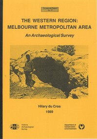
Book, The Western Region: Melbourne Metropolitan Area: An Archaeological Survey
... The Western Region: Melbourne Metropolitan Area: An Archaeological Survey...area in the vicinity west of Melbourne. The Bacchus Marsh, Melton and Werribee shire boundaries of the time defined the areas of the study. The study contains extensive lists of the types of artifacts found the the locations where they were found. Soft cover foolscap size book. 96 pages with b & w illustrations, images and maps (some folded). Part of Occasional reports series (Victoria Archaeological Survey) ; No. 27. Published by Department of Conservation and Environment, Melbourne, 1990. Author, Hilary Du Cros. BMDHS Loc. AR/SU5 The Western Region: Melbourne Metropolitan ...This study aimed to locate and document Aboriginal archaeological sites in the western region of Melbourne. This area was defined by the study as extending out from the western suburbs of Melbourne to the Brisbane Ranges and north beyond Bacchus Marsh. The specific aim of the study was to investigate the Aboriginal archaeology of the Western Plains area in the vicinity west of Melbourne. The Bacchus Marsh, Melton and Werribee shire boundaries of the time defined the areas of the study. The study contains extensive lists of the types of artifacts found the the locations where they were found.Soft cover foolscap size book. 96 pages with b & w illustrations, images and maps (some folded). Part of Occasional reports series (Victoria Archaeological Survey) ; No. 27. Published by Department of Conservation and Environment, Melbourne, 1990. Author, Hilary Du Cros. BMDHS Loc. AR/SU5This study aimed to locate and document Aboriginal archaeological sites in the western region of Melbourne. This area was defined by the study as extending out from the western suburbs of Melbourne to the Brisbane Ranges and north beyond Bacchus Marsh. The specific aim of the study was to investigate the Aboriginal archaeology of the Western Plains area in the vicinity west of Melbourne. The Bacchus Marsh, Melton and Werribee shire boundaries of the time defined the areas of the study. The study contains extensive lists of the types of artifacts found the the locations where they were found. aboriginal australians victoria western plains, aboriginal artifacts, archaelogical sites victoria western plains, aboriginal artifacts bacchus marsh region -
 Eltham District Historical Society Inc
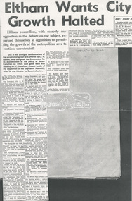
Document - Newspaper article, Diamond Valley News, Eltham Wants City Growth Halted, 31 Mar 1960
... ...Melbourne Metropolitan area...Eltham Council objects to unrestricted growth of Melbourne Metropolitan area...Eltham District Historical Society Inc 728 Main Rd Eltham melbourne Eltham Council objects to unrestricted growth of Melbourne Metropolitan area Eltham Housing development Melbourne Metropolitan area Urban Growth A3 photocopy Eltham Wants City Growth Halted Document Newspaper article Diamond Valley News ...Eltham Council objects to unrestricted growth of Melbourne Metropolitan areaeltham, housing development, melbourne metropolitan area, urban growth -
 Sunshine and District Historical Society Incorporated
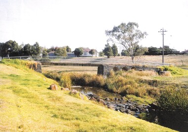
Photograph - Footbridge over Kororoit Creek Yallourn Street to Ballarat Road Ardeer, Johnson, Des, 7 Nov., 1988
... Melbourne Metropolitan Area / Ardeer, Victoria, Australia ...Donated to S&DHS1 to 6 This square blue stone foot bidge was originated by Norm stores of Derrimut Street Albion who was a Road engineer for Sunshine City Council between Yallourn Street and Sun Hill Crescent and Ballarat Road Ardeer C 1953 to 1954 Melway Map 26 B9kororoit creek, ardeer, bridge -
 Sunshine and District Historical Society Incorporated
Photograph - Kevin and Jill O'Reilly Photograph Collection, Pratt, Charles, 1922 - 1928
... Melbourne Metropolitan Area, Victoria ,, Australia ...Photograph 1 and 2 by Charles Pratt approximately mid 1924 to 1930 showing Sunshine Harvester Works and surrounding building CD disk by Brian OReilly on 3 July 2012 17 mini photographs Photo 1 Brunswick Oval North Fitzroy Photo 2 City 6 Photo 3 Collingwood Photo 4 Deer Park Ammunition Photo 5 Download 267 Deer Park Photo 6 download 268 Deer Park Photo 7 download 269 Deer Park Photo 8 download 270 Deer Park Photo 9 download 272 Deer Park Photo10 download 276 Nettlefolds Sunshine Photo 11 Creamoata Factory Footscray West Photo 12 Mitchells Sunshine and Geelong Roads Photo 13 Footscray Photo 14 Maribyrnong Photo 15 Maribyrnong Munitions Photo 16 Newmarket Stock Yards Photo 17 Sunshine Photo 2 Hunt Club Deer Park Photo 3 Maribyrnong Munitions Photo 4 Corner Sunshine Road and Geelong Road Photo 5 South Kensington Photo 6 Melbourne City Corner Flinders Street and Spencer Street and Corner Collins and Spencer Street Photo 7 Creamota Mills Sunshine Road West Footscray Photo 8 Fitzroy Football Ground Brunswick Street Photo 9 Collingwood Football Ground Victoria Park Photo 10 Footscray Football Ground Photo 11 Newmarket Saleyards Photo 12 Leather cloth Fabrex Flay Kynoch Deer Park Photo 13 Nettleford and Spaldings Phoenix Firewords Photo 14 ICI Deer Park Photo 15 ICI Deer Park Photo 16 ICI Deer Park Photo 17 ICI Deer Park Photo 18 Sunshine Harvester Works HV McKay HV McKay had a building in Argentina called Agar of Argentina There is photographs of the building and a factory and a photograph of equipmenth.v. mckays, sunshine harvester works -
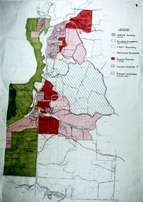
 Sunshine and District Historical Society Incorporated
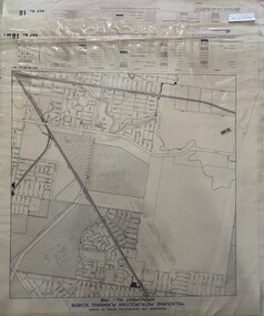
Map - Melbourne Metropolitan Planning Scheme Amendment No.1 1968, Snadden, A, et al
... 34 maps of Melbourne Metropolitan Area...City of Sunshine 34 maps of Melbourne Metropolitan Area Map Melbourne Metropolitan Planning Scheme Amendment No.1 1968 Snadden, A, et al ...city of sunshine -
 Eltham District Historical Society Inc
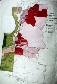
Slide - Photograph, Eltham Shire Council, Hurstbridge area, Melbourne Metropolitan Planning Scheme, Amendment No. 21, Melbourne and Metropolitan Board of Works, Apr 1972
... Hurstbridge area, Melbourne Metropolitan Planning Scheme, Amendment No. 21, Melbourne and Metropolitan Board of Works...Eltham District Historical Society Inc 728 Main Rd Eltham melbourne Map Melbourne Metropolitan Board of Works MMBW Planning Proposals shire of eltham planning 35mm colour positive transparency blue Agfacolour Service plastic mount Hurstbridge area, Melbourne Metropolitan Planning Scheme, Amendment No. 21, Melbourne and Metropolitan Board of Works Slide Photograph Eltham Shire Council ...35mm colour positive transparency blue Agfacolour Service plastic mountmap, melbourne metropolitan board of works, mmbw, planning proposals, shire of eltham, planning -
 Eltham District Historical Society Inc
Slide - Photograph, Eltham Shire Council, Hurstbridge area, Melbourne Metropolitan Planning Scheme, Amendment No. 21, Melbourne and Metropolitan Board of Works, Apr 1972
... Hurstbridge area, Melbourne Metropolitan Planning Scheme, Amendment No. 21, Melbourne and Metropolitan Board of Works...Eltham District Historical Society Inc 728 Main Rd Eltham melbourne Map Melbourne Metropolitan Board of Works MMBW Planning Proposals shire of eltham planning 35mm colour positive transparency blue Agfacolour Service plastic mount Hurstbridge area, Melbourne Metropolitan Planning Scheme, Amendment No. 21, Melbourne and Metropolitan Board of Works Slide Photograph Eltham Shire Council ...35mm colour positive transparency blue Agfacolour Service plastic mountmap, melbourne metropolitan board of works, mmbw, planning proposals, shire of eltham, planning -
![Governing the Metropolis: politics, technology and social change in a Victorian city - Melbourne, 1850-1891 / [by] David Dunstan](/media/collectors/550653872162f11fb04854aa/items/5ed0413cdcf9cd08346b6448/item-media/5ed04231dcf9cd08346b66f5/item-fit-380x285.jpg?cb=6) Kew Historical Society Inc
Kew Historical Society IncBook, Melbourne University Press, Governing the Metropolis: politics, technology and social change in a Victorian city - Melbourne, 1850-1891, 1984
... melbourne metropolitan area (vic) -- politics and government -- 1851-1891....Reference books have entered the collection through donation, presentation, collection and purchase. melbourne metropolitan area (vic) -- politics and government -- 1851-1891. urbanization -- victoria -- melbourne. ...Carlton, Vic. : Melbourne University Press, 1984 xvii, 362 p., [14] p. of plates : ill., facsims., maps, ports. ; 24 cm. non-fictionmelbourne metropolitan area (vic) -- politics and government -- 1851-1891., urbanization -- victoria -- melbourne. -
University of Melbourne, Burnley Campus Archives
Map - Geological map, Melbourne and Suburbs, 1959
... Melbourne metropolitan area...University of Melbourne, Burnley Campus Archives 500 Yarra Boulevard Richmond melbourne Melbourne metropolitan area geology Geological Survey of Victoria Department of Mines Geological map of Melbourne, 1959, modified by officers of the Geological Survey of Victoria, from earlier geological surveys. ...Geological map of Melbourne, 1959, modified by officers of the Geological Survey of Victoria, from earlier geological surveys. Scale 1:31.680melbourne metropolitan area, geology, geological survey of victoria, department of mines -
University of Melbourne, Burnley Campus Archives
Map, Melbourne Metropolitan Planning Scheme, c. 1978
... Melbourne and Metropolitan Board of Works...Melbourne metropolitan area...University of Melbourne, Burnley Campus Archives 500 Yarra Boulevard Richmond melbourne merri creek Melbourne and Metropolitan Board of Works Melbourne metropolitan area Maps showing Zones and Reservations in the Merri Creek area of Melbourne, prepared by the Drafting Department, Planning Branch, MMBW. (1) Map No 36, coloured. (2) Map No 37, coloured. (3) Map No 38, not coloured. (4) Map No 46. ...Maps showing Zones and Reservations in the Merri Creek area of Melbourne, prepared by the Drafting Department, Planning Branch, MMBW. (1) Map No 36, coloured. (2) Map No 37, coloured. (3) Map No 38, not coloured. (4) Map No 46. Scale 1:9600. May have been used in planning the Native Garden Woodland Area. merri creek, melbourne and metropolitan board of works, melbourne metropolitan area -
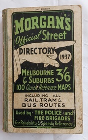 Mont De Lancey
Book, Val. Morgan and Sons Pty. Ltd, Morgan's Official Street Directory 1937, 1937
... ...Melbourne metropolitan area...Maps Street directories Road maps Melbourne metropolitan area Directories This issue represents the 20th year of publication of Morgan's Official Street Directory so a special coloured wall Map has been included showing the main arterial roads of Melbourne and Suburbs. ...This issue represents the 20th year of publication of Morgan's Official Street Directory so a special coloured wall Map has been included showing the main arterial roads of Melbourne and Suburbs. There are various important lists for reference, e.g Justices of the Peace, Index to Buildings and Chambers and more.A small Morgan's Official Street Directory, 1937. 20th Edition. Melbourne & suburbs, price 3/6. The front cover has green and black lettering on a white background. It has 100 Quick Reference Maps including all Rail, Tram & Bus Routes. Used by . The Police and Fire Brigades for Reliability & Speedy Reference. Copyright. There are may advertised businesses throughout the whole book. At the back is a free Wall Map showing the main roads of Melbourne and suburbs. The back cover has an advertisement for The Bradshaw and Everett College, 'In the City - yet out of the City at Princes Bridge'. It has green fabric tape covering the spine. There is a Forward, Contents, Index to buildings, Chambers, etc in the City, List of Justices of the Peace and more. Pp 328.non-fictionThis issue represents the 20th year of publication of Morgan's Official Street Directory so a special coloured wall Map has been included showing the main arterial roads of Melbourne and Suburbs. There are various important lists for reference, e.g Justices of the Peace, Index to Buildings and Chambers and more.maps, street directories, road maps, melbourne metropolitan area, directories -
Whitehorse Historical Society Inc.
Map, Legislative Assembly, 1984
... State of Victoria Legislative Assembly electoral districts 1983 - 1984 redivision (Melbourne Metropolitan area) Scale 1:50,000...Whitehorse Historical Society Inc. 2-10 Deep Creek Road Mitcham melbourne victoria. parliament. legislative assembly electoral boundaries State of Victoria Legislative Assembly electoral districts 1983 - 1984 redivision (Melbourne Metropolitan area) Scale 1:50,000 State of Victoria Legislative Assembly electoral districts 1983 - 1984 redivision (Melbourne Metropolitan area) Scale 1:50,000 Legislative Assembly Map Map ...State of Victoria Legislative Assembly electoral districts 1983 - 1984 redivision (Melbourne Metropolitan area) Scale 1:50,000State of Victoria Legislative Assembly electoral districts 1983 - 1984 redivision (Melbourne Metropolitan area) Scale 1:50,000State of Victoria Legislative Assembly electoral districts 1983 - 1984 redivision (Melbourne Metropolitan area) Scale 1:50,000victoria. parliament. legislative assembly, electoral boundaries -
Bendigo Historical Society Inc.
Document - BOY SCOUTS, GIRL GUIDES OFFICIAL SOUVENIR PROGRAMME, 1 Apr, 1931
... Held in Melbourne and Metropolitan area....Held in Melbourne and Metropolitan area. Cover light card mottley blue grey in colour inside cover plain blue grey, pages off white with olive print. 24 pages plus cover....Held in Melbourne and Metropolitan area. E.P. Printing & Publishing Co. ...Boy Scouts, Girl Guides Official Souvenir Programme, Commemorating the Visit to Victoria of the World Chief Scout Lord Baden Powell of Gilwell and World Chief Guide Lady Baden Powell. April, 1931. Price 1/-. The Boy Scout Movement . . . The Scout's Promise . . . The Scout Law . . . Includes photo of His Excellency, Lord Somers, Chief Scout for Victoria, page 3. Official Programme: Wednesday, 1st April through to 12th April, photo on page 8, C A Hoadley, Esq., Chief Commissioner for Victoria. Photo on page 9 Lady Baden Powell, World Chief Guide. Page 11 photo of Her Excellency, Lady Somers, Chief Guide for Victoria. Advertising in program: State Savings Bank of Victoria, Mercantile Mutual, Insurance Company Limited, Bank of New South Wales, The Union Trustee Company or Australia Limited, Kodak, A.M.P. Society, Commonwealth Savings Bank of Australia. There are 3 copies of this guide numbered 4259a,b,c. Held in Melbourne and Metropolitan area. Cover light card mottley blue grey in colour inside cover plain blue grey, pages off white with olive print. 24 pages plus cover.E.P. Printing & Publishing Co. Cnr. Pelham & Barry Sts, Carltonevent, official, boy scouts girl guides, boy scouts, girl guides official souvenir programme, commemorating the visit to victoria of the world chief scout lord baden powell of gilwell world chief guide lady baden powell. april, 1931. price 1/-. the boy scout movement. the scout's promise. the scout law. photo of his excellency, lord somers, chief scout for victoria, page 3. official programme: wednesday, 1st april through to 12th april, photo c a hoadley, esq., chief commissioner for victoria. photo lady baden powell, world chief guide. photo of her excellency, lady somers, chief guide for victoria. advertising in program: state savings bank of victoria, mercantile mutual, insurance company limited, bank of new south wales, the union trustee company or australia limited, kodak, a.m.p. society, commonwealth savings bank of australia. held in melbourne and metropolitan area. -
 Sunshine and District Historical Society Incorporated
Photograph - Set of aerial photographs of Sunshine at 27 January 1946, Government agency, Taken 27 January, 1946. Copies made c.2000
... VIC- 211 27.1.46 Run 26 Project No 5 Melbourne Metropolitan area Some photographs are from Run 27. ...Sunshine Aerial Photograph VIC- 211 27.1.46 Run 26 Project No 5 Melbourne Metropolitan area Some photographs are from Run 27. ...The photographs were obtained by Jim Cannon of Sunshine. Copies were made by Information Victoria for Norman Carlton. They were later given to Brian OReilly who donated them to Sunshine and District Historical Society.VIC- 211 27.1.46 Run 26 Project No 5 Melbourne Metropolitan area Some photographs are from Run 27. The rest of the inscription is the samesunshine, aerial photograph -
 Melbourne Legacy
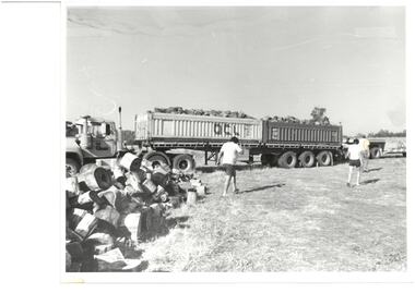
Photograph, Operation Firewood, c1966
... Some 400 tonnes of cut firewood was distributed amongst legacy Widows in the Melbourne Metropolitan Area this year (c1966). The firewood is collected by Cobram/Yarrawonga Group of Melbourne Legacy and transported free of charge to Melbourne by transport firms who provide trucks and drivers without charge. ...Stuck on paper label says "Some 400 tonnes of cut firewood was distributed amongst legacy Widows in the Melbourne Metropolitan Area this year. The firewood is collected by Cobram/Yarrawonga Group of Melbourne Legacy and transported free of charge to Melbourne by transport firms who provide trucks and drivers without charge". ...Some 400 tonnes of cut firewood was distributed amongst legacy Widows in the Melbourne Metropolitan Area this year (c1966). The firewood is collected by Cobram/Yarrawonga Group of Melbourne Legacy and transported free of charge to Melbourne by transport firms who provide trucks and drivers without charge. ...Photograph of a truck of firewood delivering wood for Operation Firewood, where firewood was delivered to widows. Some 400 tonnes of cut firewood was distributed amongst legacy Widows in the Melbourne Metropolitan Area this year (c1966). The firewood is collected by Cobram/Yarrawonga Group of Melbourne Legacy and transported free of charge to Melbourne by transport firms who provide trucks and drivers without charge. It came from a Legacy envelope marked P7, 1966. The contents were described in red pen as: 1 Christmas Party / Govt House 2 Toy presentation Dept of Education 3 Residence Christmas party 3 HMAS Cerberus / Operation Float / Operation Firewood (added in blue pen). (these other items will be items 00411 to 00416)A record of the work done to support widows.Black and white photo of a truck with a load of firewood and a paper label.Stuck on paper label says "Some 400 tonnes of cut firewood was distributed amongst legacy Widows in the Melbourne Metropolitan Area this year. The firewood is collected by Cobram/Yarrawonga Group of Melbourne Legacy and transported free of charge to Melbourne by transport firms who provide trucks and drivers without charge". Was stored in an envelope marked P7, listing it's contents in red pen and 1966 in pencil.operation firewood, widows -
 Ringwood and District Historical Society
Newspaper, Scrapbook Clipping, Library Collection, Ringwood, Victoria
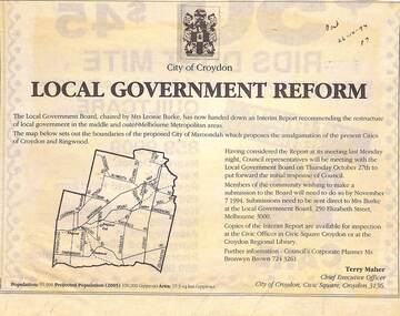
... The Local Government Board, chaired by Mrs Leonie Burke, has now handed down an Interim Report recommending the restructure of local government in the middle and outer Melbourne Metropolitan areas....Ringwood and District Historical Society 125A Warrandyte Road Ringwood North melbourne The Local Government Board, chaired by Mrs Leonie Burke, has now handed down an Interim Report recommending the restructure of local government in the middle and outer Melbourne Metropolitan areas. Newspaper Clipping from the "Post", 26-10-1994. ...Newspaper Clipping from the "Post", 26-10-1994. P7. Local Government Reform. City of Croydon.The Local Government Board, chaired by Mrs Leonie Burke, has now handed down an Interim Report recommending the restructure of local government in the middle and outer Melbourne Metropolitan areas. -
 Bendigo Military Museum
Letter - LETTERS OF SYMPATHY, DEC 1941
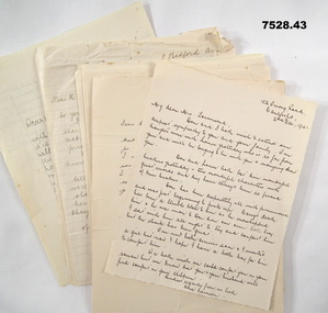
... Various handwritten letters of Sympathy for Mervyn Clive Townsend from the Melbourne Metropolitan area to his parents. Letters are of various sizes and various types of paper. ...HMAS SYDNEY KIA WW2 MERVYN CLIVE TOWNSEND Various handwritten letters of Sympathy for Mervyn Clive Townsend from the Melbourne Metropolitan area to his parents. Letters are of various sizes and various types of paper. ...Various Letters of Sympathy for Dental Surgeon "Mervyn Clive Townsend" KIA on HMAS SYDNEY 15/11/41. Refer Cat No. 2313P for Townsends service.Various handwritten letters of Sympathy for Mervyn Clive Townsend from the Melbourne Metropolitan area to his parents. Letters are of various sizes and various types of paper. All dated in late November to December 1941. Forty three (43) letters in total.hmas sydney, kia, ww2, mervyn clive townsend -
Whitehorse Historical Society Inc.
Document, Archaeology of Aboriginal sites, 11/04/1984
... Summary of a talk by Gary Presland of the Victorian Department of Archaeology by Joan Roczniok on the archaeology of aboriginal sites in the Melbourne Metropolitan area. Archaeological practices, Aboriginals, whalers, French Island, Keilor site, Main Street, Blackburn, canoe tree, axes, hunting and fishing methods....Whitehorse Historical Society Inc. 2-10 Deep Creek Road Mitcham melbourne Aborigines Main Street Blackburn Blackburn French Island Keilor Archaeology Summary of a talk by Gary Presland of the Victorian Department of Archaeology by Joan Roczniok on the archaeology of aboriginal sites in the Melbourne Metropolitan area. Archaeological practices, Aboriginals, whalers, French Island, Keilor site, Main Street, Blackburn, canoe tree, axes, hunting and fishing methods. ...Summary of a talk by Gary Presland of the Victorian Department of Archaeology by Joan Roczniok on the archaeology of aboriginal sites in the Melbourne Metropolitan area. Archaeological practices, Aboriginals, whalers, French Island, Keilor site, Main Street, Blackburn, canoe tree, axes, hunting and fishing methods.aborigines, main street, blackburn, blackburn, french island, keilor, archaeology -
 Melbourne Tram Museum
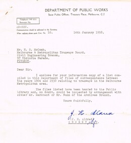
Document - Personal Papers, Department of Public Works, correspondence between the years 1904 and 1930 relating to tramway, 14/01/1958 12:00:00 AM
... McComb of records of correspondence between the years 1904 and 1930 relating to tramways in the Melbourne Metropolitan Area. These records had been forwarded to the State Library of Victoria Archives Branch....McComb of records of correspondence between the years 1904 and 1930 relating to tramways in the Melbourne Metropolitan Area. These records had been forwarded to the State Library of Victoria Archives Branch. correspondence between the years 1904 and 1930 relating to tramway Document Personal Papers Department of Public Works ...Letter and copy of a list - from the Department of Public Works - dated 14/1/1958 forwarding a list to Mr. McComb of records of correspondence between the years 1904 and 1930 relating to tramways in the Melbourne Metropolitan Area. These records had been forwarded to the State Library of Victoria Archives Branch.trams, tramways, tramways, mmtb, lists, index, records