Showing 356 items matching "melbourne ring road"
-
 Eltham District Historical Society Inc
Book, The Joint Road Planning Group, Outer Ring Study, Diamond Creek to Ringwood: Technical Report Transport and Economic Evaluation, July 1979
... melbourne ring road...Eltham District Historical Society Inc 728 Main Rd Eltham melbourne melbourne ring road roads freeways Prepared for The Road Planning Liaison Committee by The Joint Road Planning Group. ...Prepared for The Road Planning Liaison Committee by The Joint Road Planning Group. The Outer Ring Study, Diamond Creek to Ringwood was a long term planning study carried out under the direction of the Road Planning Liaison Committee for the Government of Victoria. .. The basic aim of the .. Study was to determine the most appropriate future road system in the area between Diamond Creek and Ringwood, consistent with local and regional concerns and the environment of the area, with a view to seeking an emendment to the Metropolitan Planning Scheme to preserve the option to implement an appropriate road system some time in the future if this was considered necessary. This technical report discusses, in detail, the transport and economic aspects of the investigation.. the techniques used take into account the long term implications of a range of possible travel cost policies and options and land use strategies.non-fictionPrepared for The Road Planning Liaison Committee by The Joint Road Planning Group. The Outer Ring Study, Diamond Creek to Ringwood was a long term planning study carried out under the direction of the Road Planning Liaison Committee for the Government of Victoria. .. The basic aim of the .. Study was to determine the most appropriate future road system in the area between Diamond Creek and Ringwood, consistent with local and regional concerns and the environment of the area, with a view to seeking an emendment to the Metropolitan Planning Scheme to preserve the option to implement an appropriate road system some time in the future if this was considered necessary. This technical report discusses, in detail, the transport and economic aspects of the investigation.. the techniques used take into account the long term implications of a range of possible travel cost policies and options and land use strategies.melbourne ring road, roads, freeways -
 Eltham District Historical Society Inc
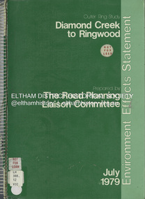
Book, The Road Planning Liaison Committee, Outer Ring Study, Diamond Creek to Ringwood: Environmental Effects Statement, July 1979
... ...melbourne ring road...Eltham District Historical Society Inc 728 Main Rd Eltham melbourne roads freeways melbourne ring road Prepared by The Road Planning Liaison Committee. ...Prepared by The Road Planning Liaison Committee. The Outer Ring Study, Diamond Creek to Ringwood was a long term planning study carried out under the direction of the Road Planning Liaison Committee for the Government of Victoria. .. The basic aim of the .. Study was to determine the most appropriate future road system in the area between Diamond Creek and Ringwood, consistent with local and regional concerns and the environment of the area, with a view to seeking an emendment to the Metropolitan Planning Scheme to preserve the option to implement an appropriate road system some time in the future if this was considered necessary.non-fictionPrepared by The Road Planning Liaison Committee. The Outer Ring Study, Diamond Creek to Ringwood was a long term planning study carried out under the direction of the Road Planning Liaison Committee for the Government of Victoria. .. The basic aim of the .. Study was to determine the most appropriate future road system in the area between Diamond Creek and Ringwood, consistent with local and regional concerns and the environment of the area, with a view to seeking an emendment to the Metropolitan Planning Scheme to preserve the option to implement an appropriate road system some time in the future if this was considered necessary.roads, freeways, melbourne ring road -
 Eltham District Historical Society Inc
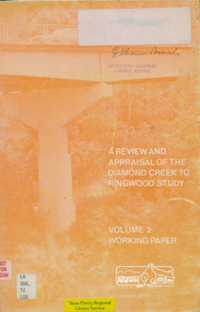
Book, A Review and Appraisal of the Diamond Creek to Ringwood Study, volume 2, working paper, by Loder and Bayly, 1979
... melbourne ring road...Includes fold out maps. melbourne ring road Roads freeways 91 p, maps, 27 cm. ...Volume 2: Working papers. This report is a review and appraisal of the Outer Ring Road Study Diamond Creek to Ringwood prepared for The Road Planning Liaison Committee by the Joint Road Planning Group for the The City of Doncaster & Templestowe and The Shire of Eltham by Loder & Bayly Planning & Engineering Consultants. "This paper attempts to set a framework for an evaluation of the recommended road link between Diamond Creek and Ringwood." Various perspectives are examined. Includes fold out maps.91 p, maps, 27 cm.melbourne ring road, roads, freeways -
 Broadmeadows Historical Society & Museum
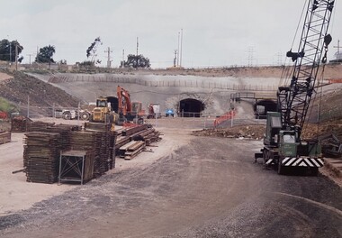
Photograph - Road - Ring Road, Construction of the Jacana Underpass, c. 1990s
... This photograph documents the construction of the Jacana Underpass Tunnel, a landmark infrastructure project undertaken to allow Melbourne’s Western Ring Road to pass beneath a complex transport corridor. ...This photograph documents a pivotal moment in the construction of the Jacana Underpass Tunnel, part of Melbourne’s Western Ring Road infrastructure project undertaken in the early 1990s. ...This photograph documents the construction of the Jacana Underpass Tunnel, a landmark infrastructure project undertaken to allow Melbourne’s Western Ring Road to pass beneath a complex transport corridor. The corridor included Pascoe Vale Road, Electric Street, and four active railway lines—two broad gauge, one standard gauge, and one commuter line—making traditional tunneling or bridging methods impractical. The tunnel was constructed using a pioneering hydraulic jacking technique, where precast concrete tunnel segments, each weighing approximately 1200 tonnes, were pushed into place through pilot tunnels. This method minimised disruption to the busy transport corridor above, which carried tens of thousands of vehicles and multiple rail services daily. The Jacana Underpass Tunnel was constructed between 1992 and 1993 as part of Melbourne’s Western Ring Road project, a major infrastructure initiative aimed at improving traffic flow and connectivity across the city’s northern suburbs. The underpass was designed to carry the freeway beneath a complex transport corridor that included Pascoe Vale Road, Electric Street, and four active railway lines—two broad gauge, one standard gauge, and one commuter line. Due to the shallow depth of cover—less than one metre in some areas—and the need to maintain uninterrupted road and rail services above, engineers employed an innovative hydraulic jacking technique. This involved pushing precast concrete tunnel segments, each weighing approximately 1200 tonnes, through pilot tunnels using hydraulic rams. The method was one of the largest of its kind in Australia at the time and allowed for the safe and efficient installation of the tunnel without open excavation. The photograph captures a key stage in the construction process, showing the dual tunnel portals, heavy machinery, and construction materials on site. It reflects the scale, complexity, and ingenuity of late 20th-century civil engineering in Victoria and provides valuable insight into the evolution of Melbourne’s transport infrastructure.This photograph documents a pivotal moment in the construction of the Jacana Underpass Tunnel, part of Melbourne’s Western Ring Road infrastructure project undertaken in the early 1990s. The image features two tunnel entrances under construction, surrounded by heavy machinery, construction materials, and temporary fencing, with a dirt access road leading into the site. The Jacana Underpass was constructed using a hydraulic jacking technique, a method that allowed large precast concrete tunnel segments—each weighing approximately 1200 tonnes—to be installed beneath a live transport corridor without disrupting traffic or rail services. This innovative approach was one of the largest of its kind in Australia and addressed significant engineering challenges, including shallow cover and complex geological conditions. The photograph is significant for its documentation of advanced civil engineering practices and the transformation of Melbourne’s northern suburbs through major infrastructure development. It provides insight into the construction techniques, site logistics, and material use typical of large-scale tunneling projects in the late 20th century. As part of an archival collection, this image contributes to the historical record of urban growth, transport planning, and engineering innovation in Victoria. It holds enduring value for researchers, historians, and infrastructure professionals studying the evolution of public works in the state.Colour photo. Construction Site. Jacana underpass tunnel.(Back - blue pen) 'Underpass/Jacana'underpass, jacana, construction, 1990's, jacana underpass tunnel, western ring road -
 Warrnambool and District Historical Society Inc.
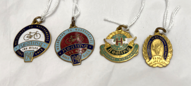
Medal - Four medals - Melbourne to Warrnambool Cycle Race
... Melbourne to Warrnambool Cycle Race Ron Vernon Cyclist Warrnambool Sport .1 Melbourne to Warrnambool Road Race 165 miles Healing 1947 .2 Melbourne to Warrnambool Road Race 165 miles Healing 1948 .3 Melbourne-Warrnambool 165 miles Healing 1950 .4 Warrnambool to Melbourne Road Race Time Medallion 1960 .1 A round metal medal with a dark blue band around the edge, a light blue strip across the middle and a light blue tab at the bottom of the medal. The medal has gold-coloured printing and a gold image of a bicycle. A metal ring ...These four medals relate to the Melbourne to Warrnambool Cycle Race. This race was first held in 1895 and continues to the presenr day. It was originally a handicap race from Warrnambool to Melbourne but after 1938 it became a Melbourne to Warrnambool race After 1995 it became a scratch race and today the distance is shorter with the race starting from Avalon. It is the second oldest one-day cycling race in the world and the longest one-day cycling race in Australia. Four of these medals were awarded to Ron Vernon from the Footscray Club. All riders who complete the race in a given time are awarded a Time Medallion. In 1947 Ron Vernon, riding the latest Healing Championship Cycle came in 26th. In 1948, riding off the 47 minute handicap, he took 7th place. IHe also won the Colac Sprint in that race. In 1950 he took 9th place. The fourth medal is a Time Medallion awarded to a cyclist in 1960. These medals are of considerable interest as mementoes of the Melbourne to Warrnambool Cycle Race, an important sporting event associated with Warrnambool and one that is known Australia-wide and internationally..1 A round metal medal with a dark blue band around the edge, a light blue strip across the middle and a light blue tab at the bottom of the medal. The medal has gold-coloured printing and a gold image of a bicycle. A metal ring is attached at the top. .2 a round metal medal similar in design to .1 above with light blue, dark blue and red colouring. A metal ring is attached at the top .3 a green and gold round metal medal with a green curved strip attached to the bottom of the medal and white wings placed in the middle of the medal. The labelling is red and gold. A metal ring is attached at the top. .4 A gold and dark blue oval-shaped metal medal. A metal ring is attached at the top. .1 Melbourne to Warrnambool Road Race 165 miles Healing 1947 .2 Melbourne to Warrnambool Road Race 165 miles Healing 1948 .3 Melbourne-Warrnambool 165 miles Healing 1950 .4 Warrnambool to Melbourne Road Race Time Medallion 1960melbourne to warrnambool cycle race, ron vernon cyclist, warrnambool sport -
 Warrnambool and District Historical Society Inc.
Medallion, Stokes Melbourne, Centenary of Victoria 1935, 1933
... road This medal was given to Victorian school children to celebrate the centenary of European settlement in Victoria and the establishment of Melbourne in 1835. Portland was settled by the Henty brothers and John Batman and John Fawkner are the two names associated with the founding of Melbourne. The Melbourne Shrine of Remembrance was dedicated during these celebrations. This medal is a memento of the centenary of Victoria and may have been given a local Warrnambool school child. Obverse CENTENARY OF VICTORIA 1934 PORTLAND 1834 Reverse CENTENARY OF MELBOURNE 1935 1835 Circular silver coloured medal with ring ...This medal was given to Victorian school children to celebrate the centenary of European settlement in Victoria and the establishment of Melbourne in 1835. Portland was settled by the Henty brothers and John Batman and John Fawkner are the two names associated with the founding of Melbourne. The Melbourne Shrine of Remembrance was dedicated during these celebrations. This medal is a memento of the centenary of Victoria and may have been given a local Warrnambool school child. Circular silver coloured medal with ring at top and a further ring inserted. The obverse features a sailing ship entering a bay. Since "Portland " is part of the text it is assumed the bay is situated in Portland. Text The reverse features a hatted man wearing a suit and holding a walking stick standing on a grassy shore, a body of water and a sky line of buildings Obverse CENTENARY OF VICTORIA 1934 PORTLAND 1834 Reverse CENTENARY OF MELBOURNE 1935 1835 -
Glen Eira Historical Society
Letter - Crotonhurst
... Glen Eira Historical Society 965 Glen Huntly Rd Caulfield VIC 3162 melbourne A letter from Mrs M Ring to the Caulfield Historical Society, dated 14/03/1986, conveying gratitude for the information provided about the house Crotonhurst located at the corner of Hawthorn Road and Glen Eira Road, Caulfield North, and requesting information about the Langdon and Webb families and the property Lirrewa. ...A letter from Mrs M Ring to the Caulfield Historical Society, dated 14/03/1986, conveying gratitude for the information provided about the house Crotonhurst located at the corner of Hawthorn Road and Glen Eira Road, Caulfield North, and requesting information about the Langdon and Webb families and the property Lirrewa. Enclosed with the letter is a copy of a two page report on the Life of George Frederick Webb. The file also includes a seven page report conducted by Irene Victoria Anderson in 1982 on the history of the Langdon and Webb families and the house Crotonhurst. Two earlier drafts of the same report are included and one of these has further handwritten notes.crotonhurst, rosecraddock, lirrewa, caulfield north, hawthorn road, langdon road, glen eira road, mitchell road, crotonhurst avenue, caulfield city hall, city of caulfield, polo ground, polo parade, neerim road, powderham road, walworth avenue, langdon family, webb family, rosecraddock family, webb george henry frederick, webb george henry webb justice, field matilda, agg sophia sarah, agg sophia sarah annie, webb sophie sarah annie, agg dottie, webb dottie, langdon william farrar, langdon willie, langdon bill, langdon h j mrs, langdon mrs, webb george edward, webb matilda elizabeth, webb isabella elizabeth, webb james hemming, murray peter r, wells john c, langdon marie, langdon clive, murdoch keith, egerton-warburton mr, yorston mr, yorston rita, langdon violet, langdon. philip, gillespie ray, lindsay joan, ring m, paterson mrs, coffey eileen, fitzsimmons eileen, ronald heather, william gluyas, maidment isobel, langdon rr, langdon charles, langdon r b, knox david, langdon dick, hart trevor, mclaughlin j, ballantyne r, webb matilda sarah, somers charles, mckenzie barbara, mcleod lexie, richards barbara, richards lexie, sims betty, anderson irene victoria, short hand writer, lawyers, phthisis, queen’s counsel, judge of the supreme court, court reporter, architectural features, world war 1914-1918, soldiers, point to point steeplechase, master of the hounds, organs, sculptor, statues, stained glass, crests and emblems, elsternwick congregational church, government shorthand writers’ department, eureka treason trials, swamp sand and heath, dickson and yorston, caulfield council, caulfield historical society, harrison ramsay, time without clocks, the hounds are running, melbourne hunt club, st mary’s church, geo. fincham and sons, city hall gallery, mansions -
Glen Eira Historical Society
Document - St. Georges Road, 68, Elsternwick
... melbourne Two documents about the history and features of this property. A typed report about the ownership and occupancy from 1906 to 1978 of 68 St. Georges Road dated 21/07/1987 researched by Hailary Bullock and Rosalind Landells with handwritten working notes. Two evaluations, one for the house dated 05/05/1954, and one for the furnishings inside the house. St. Georges Road George Road Elsternwick Frederick Sargood Estate Sargood F. Ripponlea Ring ...Two documents about the history and features of this property. A typed report about the ownership and occupancy from 1906 to 1978 of 68 St. Georges Road dated 21/07/1987 researched by Hailary Bullock and Rosalind Landells with handwritten working notes. Two evaluations, one for the house dated 05/05/1954, and one for the furnishings inside the house.st. georges road, george road, elsternwick, frederick sargood estate, sargood f., ripponlea, ring c., wrigley leslie j., belle vue, young stephen, locksley, cutts herbert, robertson david, robertson ada, edwards joseph, cording william, rybajzen jeko szaul, bullock hilary, landells rosalind, brighton historical society, architectural features, houses, land values, furnishings, brick houses, verandahs, cast iron work, edwards mrs -
 Greensborough Historical Society
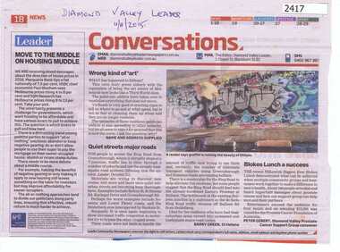
Newspaper Clipping, Conversations - Greensborough Ring Road, 11/11/2015
... Greensborough Historical Society 34A Glenauburn Road Lower Plenty Lower Plenty melbourne Letters to the editor of Diamond Valley Leader covering graffiti in Eltham and traffic around the Metropolitan Ring Road. metropolitan ring road graffiti News clipping, black text, colour image. ...Letters to the editor of Diamond Valley Leader covering graffiti in Eltham and traffic around the Metropolitan Ring Road.News clipping, black text, colour image.metropolitan ring road, graffiti -
 Greensborough Historical Society
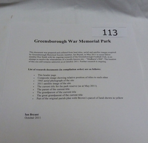
Work on paper - Folder of Documents, Ian Bryant, War Memorial Park Greensborough, 2011_
... Greensborough Historical Society 34A Glenauburn Road Lower Plenty Lower Plenty melbourne Folder of documents about War Memorial Park Greensborough including aerial photographs and title documents (collected by Ian Bryant) and other information on War Memorial Park bordered by McDowell Street, Ester Street, Henry Street and Vermont Parade Greensborough. greensborough war memorial park public space war memorials ian bryant parks banyule Folder of documents - 2 ring binder and A4 printed pages in plastic pockets. ...Folder of documents about War Memorial Park Greensborough including aerial photographs and title documents (collected by Ian Bryant) and other information on War Memorial Park bordered by McDowell Street, Ester Street, Henry Street and Vermont Parade Greensborough.Folder of documents - 2 ring binder and A4 printed pages in plastic pockets.greensborough war memorial park, public space, war memorials, ian bryant, parks banyule -
 Greensborough Historical Society
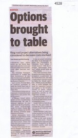
Newspaper Clipping, Diamond Valley Leader et al, Options brought to table, 18/01/2017
... Greensborough Historical Society 34A Glenauburn Road Lower Plenty Lower Plenty melbourne A radical plan, which would see the North East Link built with fly-overs and trenches rather than tunnels, could affect Banyule residents. north east link banyule metropolitan ring road News article 1 page, black text. ...A radical plan, which would see the North East Link built with fly-overs and trenches rather than tunnels, could affect Banyule residents.News article 1 page, black text.north east link, banyule, metropolitan ring road -
 Greensborough Historical Society
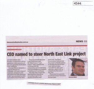
Newspaper Clipping, Diamond Valley Leader, CEO named to steer North East Link project, 01/03/2017
... Greensborough Historical Society 34A Glenauburn Road Lower Plenty Lower Plenty melbourne An engineer with decades of experience will be appointed chief executive of the new specialist North East Link Authority. north east link metropolitan ring road duncan elliott News article 1 page, black text, colour image. ...An engineer with decades of experience will be appointed chief executive of the new specialist North East Link Authority.News article 1 page, black text, colour image.north east link, metropolitan ring road, duncan elliott -
 Greensborough Historical Society
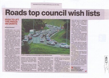
Newspaper Clipping, Diamond Valley Leader, Roads top council wish lists, 29/06/2016
... Greensborough Historical Society 34A Glenauburn Road Lower Plenty Lower Plenty melbourne Traffic issues in Banyule and surrounding areas are discussed. traffic north east link banyule council metropolitan ring road banyule city council News clipping, black text and colour image Roads top council wish lists Newspaper Clipping Diamond Valley Leader ...Traffic issues in Banyule and surrounding areas are discussed.News clipping, black text and colour imagetraffic, north east link, banyule council, metropolitan ring road, banyule city council -
 Greensborough Historical Society
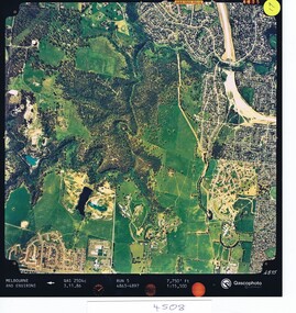
Aerial photograph, Qascophoto, Greensborough, 03/11/1986
... Greensborough Historical Society 34A Glenauburn Road Lower Plenty Lower Plenty melbourne Aerial survey of Plenty Gorge Park area, including Greensborough by-pass construction and Metropolitan Ring Road reservation. ...Aerial survey of Plenty Gorge Park area, including Greensborough by-pass construction and Metropolitan Ring Road reservation.An historical view of developing GreensboroughColour aerial photograph QAS 2504c run 5 3/11/86 1:15,500 by Qascophotoplenty gorge park, greensborough bypass, metropolitan ring road -
 Greensborough Historical Society
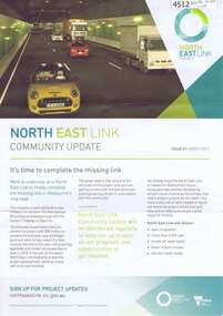
Newsletter - Leaflet, North East Link Authority, North East Link community update: Issue 01 March 2017, 2017
... Road Lower Plenty Lower Plenty melbourne The North East Link Authority was set up to lead development of this project. The commencement of technical work has been approved by the State Government of Victoria. This newsletter, and additional leaflets, are to keep the community informed of project designs, developments and opportunities for consultation. An ongoing collection of community updates north east link metropolitan ring ...The North East Link Authority was set up to lead development of this project. The commencement of technical work has been approved by the State Government of Victoria. This newsletter, and additional leaflets, are to keep the community informed of project designs, developments and opportunities for consultation. An ongoing collection of community updates4 page leaflet, colour text and images; with further community updates on topics related to the projectnorth east link, metropolitan ring road, north east link tunnels -
 Greensborough Historical Society
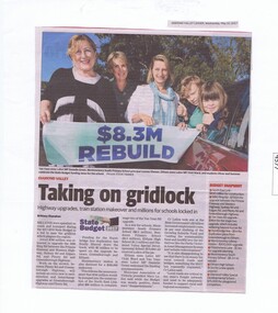
Newspaper Clipping, Diamond Valley Leader, Taking on gridlock, 10/05/2017
... Greensborough Historical Society 34A Glenauburn Road Lower Plenty Lower Plenty melbourne Millions were splashed on roads and transport during the 2017-2018 State Budget in a bid to ease the gridlock which plagues the region. Including improvements to the Greensborough end of the Western (Metropolitan) Ring ...Millions were splashed on roads and transport during the 2017-2018 State Budget in a bid to ease the gridlock which plagues the region. Including improvements to the Greensborough end of the Western (Metropolitan) Ring Road.News article 1 page, black text, colour image.transport, metropolitan ring road -
 Greensborough Historical Society
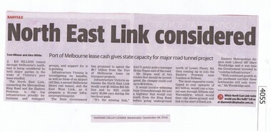
Newspaper Clipping, Diamond Valley Leader, North East Link considered, 28/09/2016
... Greensborough Historical Society 34A Glenauburn Road Lower Plenty Lower Plenty melbourne The proposed North East Link will connect the Western Ring Road and the Eastern Freeway. north east link western ring road News clipping, black text. ...The proposed North East Link will connect the Western Ring Road and the Eastern Freeway.News clipping, black text.north east link, western ring road -
 Greensborough Historical Society
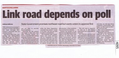
Newspaper Clipping, Diamond Valley Leader, Link road depends on poll, 14/12/2016
... Greensborough Historical Society 34A Glenauburn Road Lower Plenty Lower Plenty melbourne The North East Link will connect the Metropolitan Ring Road and Eastern Freeway. ...The North East Link will connect the Metropolitan Ring Road and Eastern Freeway. It is under consideration by the Victorian Government.News clipping, black text. north east link, metropolitan ring road -
 Greensborough Historical Society
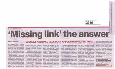
Newspaper Clipping, "Missing Link" the answer, 21/10/2015
... Greensborough Historical Society 34A Glenauburn Road Lower Plenty Lower Plenty melbourne Both Banyule and Nillumbik Councils support the East West Link Project between the Metropolitan Ring Road and Eastern Freeway. east west link project metropolitan ring road nillumbik council banyule city council News clipping, black text. ...Both Banyule and Nillumbik Councils support the East West Link Project between the Metropolitan Ring Road and Eastern Freeway.News clipping, black text.east west link project, metropolitan ring road, nillumbik council, banyule city council -
 Greensborough Historical Society
Article, Royal Automobile Club of Victoria et al, Ring of ire, 2016_02
... Greensborough Historical Society 34A Glenauburn Road Lower Plenty Lower Plenty melbourne Discussion of the need to provide a link between the Metropolitan Ring Road at Greensborough and the Eastlink at either Bulleen or Ringwood, to alleviate traffic congestion on Rosanna Road and other streets in the Banyule area. eastlink metropolitan ring road rosanna road rosanna Royal Auto Feb. 2016 p. 15-19 Four pages, text and coloured photographs Ring of ire Article Royal Automobile Club of Victoria Paul Edwards ...Discussion of the need to provide a link between the Metropolitan Ring Road at Greensborough and the Eastlink at either Bulleen or Ringwood, to alleviate traffic congestion on Rosanna Road and other streets in the Banyule area.Four pages, text and coloured photographsRoyal Auto Feb. 2016 p. 15-19eastlink, metropolitan ring road, rosanna road rosanna -
Greensborough Historical Society
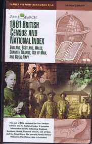
CD-ROM, Church of Jesus Christ of Latter-Day Saints, 1881 Census for Great Britain by region, with National Index and Resource File Viewer disc, 1881_
... Greensborough Historical Society 34A Glenauburn Road Lower Plenty Lower Plenty melbourne Covers data for England, Scotland, Wales, Channel Islands, Isle of Man by Regions and the Royal Navy. Ring ...Covers data for England, Scotland, Wales, Channel Islands, Isle of Man by Regions and the Royal Navy.Ring binder containing 24 CDs -
 Greensborough Historical Society
CD-ROM, Church of Jesus Christ of Latter-Day Saints, 1881 British Census and National Index, 1881_
... Greensborough Historical Society 34A Glenauburn Road Lower Plenty Lower Plenty melbourne Comprises data for England, Scotland, wales, Channel Islands, Isle of Man by Regions, and the Royal Navy, with Family History resource File Viewer disc. family history Ring binder containing 24 CD-Roms 1881 British Census and National Index CD-ROM Church of Jesus Christ of Latter-Day Saints ...Comprises data for England, Scotland, wales, Channel Islands, Isle of Man by Regions, and the Royal Navy, with Family History resource File Viewer disc.Ring binder containing 24 CD-Romsfamily history -
 Greensborough Historical Society
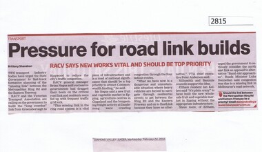
Newspaper Clipping, Diamond Valley Leader, Pressure for road link builds, 24/02/2016
... Greensborough Historical Society 34A Glenauburn Road Lower Plenty Lower Plenty melbourne RACV reports that the missing link between the Metropolitan Ring Road and Eastern Freeway should be a priority. eastern freeway east west link project metropolitan ring road News clipping, black text. ...RACV reports that the missing link between the Metropolitan Ring Road and Eastern Freeway should be a priority.News clipping, black text.eastern freeway, east west link project, metropolitan ring road -
 Greensborough Historical Society
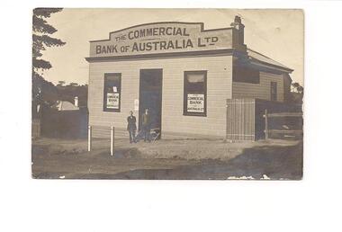
Photograph - Digital image, Commercial Bank Greensborough, 1913_
... Greensborough Historical Society 34A Glenauburn Road Lower Plenty Lower Plenty melbourne An early photograph of the Commercial Bank of Australia, Greensborough Branch in Main Street Greensborough, taken before 1914. Teller Walter West stands on the left (according to his grandson John Cramp). The rings ...An early photograph of the Commercial Bank of Australia, Greensborough Branch in Main Street Greensborough, taken before 1914. Teller Walter West stands on the left (according to his grandson John Cramp). The rings on the white posts are for tethering the horses. After service in World War 1 West married the daughter of Greensborough butcher Mr. N. Elliot and moved to a soldier settlement fruit block at Redcliffs.Digital copy of black and white photograph.commercial bank of australia, main street greensborough -
 Greensborough Historical Society
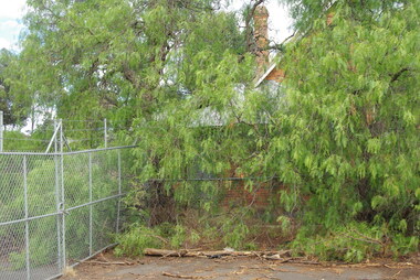
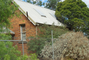
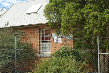
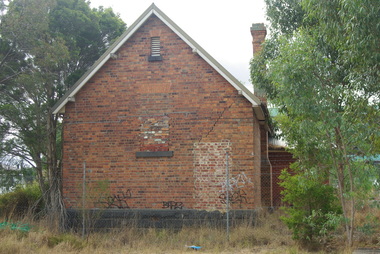
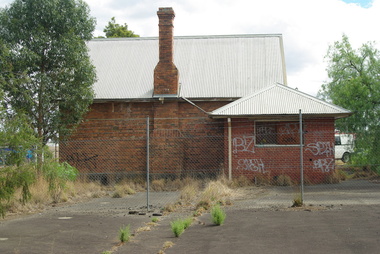
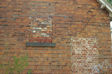
Photograph - Digital Image, Bundoora Primary School Bu1915 (old building) 1, 18/03/2014
... Road Lower Plenty Lower Plenty melbourne Bundoora Primary School No.1915 was constructed in 1877 of brick on a bluestone base with an iron roof and small porch. The school consisted of a single room with the dimensions 30 feet by 18 feet. It was a small rural school and in use for over 100 years. Today it sits abandoned at the intersection of Plenty Road and the Metropolitan Ring ...Bundoora Primary School No.1915 was constructed in 1877 of brick on a bluestone base with an iron roof and small porch. The school consisted of a single room with the dimensions 30 feet by 18 feet. It was a small rural school and in use for over 100 years. Today it sits abandoned at the intersection of Plenty Road and the Metropolitan Ring Road. The School has a Victorian Heritage Overlay (no H062) Photograph by Marilyn Smith 2014. Update: The old building has been incorporated into a childcare facility.Digital copy of colour photograph. bundoora primary school, bundoora state school -
 Greensborough Historical Society
Photograph - Digital Image, Bundoora Primary School Bu1915 (old building) 2, 18/03/2014
... Road Lower Plenty Lower Plenty melbourne Bundoora Primary School No.1915 was constructed in 1877 of brick on a bluestone base with an iron roof and small porch. The school consisted of a single room with the dimensions 30 feet by 18 feet. It was a small rural school and in use for over 100 years. Today it sits abandoned at the intersection of Plenty Road and the Metropolitan Ring ...Bundoora Primary School No.1915 was constructed in 1877 of brick on a bluestone base with an iron roof and small porch. The school consisted of a single room with the dimensions 30 feet by 18 feet. It was a small rural school and in use for over 100 years. Today it sits abandoned at the intersection of Plenty Road and the Metropolitan Ring Road. The School has a Victorian Heritage Overlay (no H062) Photograph by Marilyn Smith 2014. Update: The old building has been incorporated into a childcare facility.Digital copy of colour photograph. bundoora primary school, bundoora state school -
 Greensborough Historical Society
Photograph - Digital Image, Bundoora Primary School Bu1915 (old building) 3, 18/03/2014
... Road Lower Plenty Lower Plenty melbourne Bundoora Primary School No.1915 was constructed in 1877 of brick on a bluestone base with an iron roof and small porch. The school consisted of a single room with the dimensions 30 feet by 18 feet. It was a small rural school and in use for over 100 years. Today it sits abandoned at the intersection of Plenty Road and the Metropolitan Ring ...Bundoora Primary School No.1915 was constructed in 1877 of brick on a bluestone base with an iron roof and small porch. The school consisted of a single room with the dimensions 30 feet by 18 feet. It was a small rural school and in use for over 100 years. Today it sits abandoned at the intersection of Plenty Road and the Metropolitan Ring Road. The School has a Victorian Heritage Overlay (no H062) Photograph by Marilyn Smith 2014. Update: The old building has been incorporated into a childcare facility.Digital copy of colour photograph. bundoora primary school, bundoora state school -
 Greensborough Historical Society
Photograph - Digital Image, Bundoora Primary School Bu1915 (old building) 4, 18/03/2014
... Road Lower Plenty Lower Plenty melbourne Bundoora Primary School No.1915 was constructed in 1877 of brick on a bluestone base with an iron roof and small porch. The school consisted of a single room with the dimensions 30 feet by 18 feet. It was a small rural school and in use for over 100 years. Today it sits abandoned at the intersection of Plenty Road and the Metropolitan Ring ...Bundoora Primary School No.1915 was constructed in 1877 of brick on a bluestone base with an iron roof and small porch. The school consisted of a single room with the dimensions 30 feet by 18 feet. It was a small rural school and in use for over 100 years. Today it sits abandoned at the intersection of Plenty Road and the Metropolitan Ring Road. The School has a Victorian Heritage Overlay (no H062) Photograph by Marilyn Smith 2014. Update: The old building has been incorporated into a childcare facility.Digital copy of colour photograph. bundoora primary school, bundoora state school -
 Greensborough Historical Society
Photograph - Digital Image, Bundoora Primary School Bu1915 (old building) 5, 18/03/2014
... Road Lower Plenty Lower Plenty melbourne Bundoora Primary School No.1915 was constructed in 1877 of brick on a bluestone base with an iron roof and small porch. The school consisted of a single room with the dimensions 30 feet by 18 feet. It was a small rural school and in use for over 100 years. Today it sits abandoned at the intersection of Plenty Road and the Metropolitan Ring ...Bundoora Primary School No.1915 was constructed in 1877 of brick on a bluestone base with an iron roof and small porch. The school consisted of a single room with the dimensions 30 feet by 18 feet. It was a small rural school and in use for over 100 years. Today it sits abandoned at the intersection of Plenty Road and the Metropolitan Ring Road. The School has a Victorian Heritage Overlay (no H062) Photograph by Marilyn Smith 2014. Update: The old building has been incorporated into a childcare facility.Digital copy of colour photograph. bundoora primary school, bundoora state school -
 Greensborough Historical Society
Photograph - Digital Image, Bundoora Primary School Bu1915 (old building) 6, 18/03/2014
... Road Lower Plenty Lower Plenty melbourne Bundoora Primary School No.1915 was constructed in 1877 of brick on a bluestone base with an iron roof and small porch. The school consisted of a single room with the dimensions 30 feet by 18 feet. It was a small rural school and in use for over 100 years. Today it sits abandoned at the intersection of Plenty Road and the Metropolitan Ring ...Bundoora Primary School No.1915 was constructed in 1877 of brick on a bluestone base with an iron roof and small porch. The school consisted of a single room with the dimensions 30 feet by 18 feet. It was a small rural school and in use for over 100 years. Today it sits abandoned at the intersection of Plenty Road and the Metropolitan Ring Road. The School has a Victorian Heritage Overlay (no H062) Photograph by Marilyn Smith 2014. Update: The old building has been incorporated into a childcare facility.Digital copy of colour photograph. bundoora primary school, bundoora state school