Showing 306 items matching "melway"
-
 Sunshine and District Historical Society Incorporated
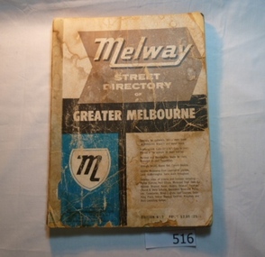
Book - Melway Greater Melbourne Street Directory 1996, Melway Publishing Pty Ltd, 1996
... Melway Greater Melbourne Street Directory 1996...Melway Greater Melbourne Street Directory Edition 24...Melway Publishing Pty Ltd...Melway Greater Melbourne Street Directory Edition 24 Paper back book Melway Greater Melbourne Street Directory 1996 Book Melway Greater Melbourne Street Directory 1996 Melway Publishing Pty Ltd Pac-Rim Direct ...The series of Melway Directories provides the most comprehensive maps of Great Melbourne area. Published in May 1996, this edition has been fully revised and may new features have been added. This Melway provides maps of the Greater Melbourne area extending to Bacchus Marsh, Geelong, Bellarine and Mornington Peninsulas, Healesville and Phillip Island. Past editions of the Melway can provide invaluable material for researchers and historians.Paper back booknon-fictionThe series of Melway Directories provides the most comprehensive maps of Great Melbourne area. Published in May 1996, this edition has been fully revised and may new features have been added. This Melway provides maps of the Greater Melbourne area extending to Bacchus Marsh, Geelong, Bellarine and Mornington Peninsulas, Healesville and Phillip Island. Past editions of the Melway can provide invaluable material for researchers and historians. -
 Eltham District Historical Society Inc
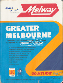
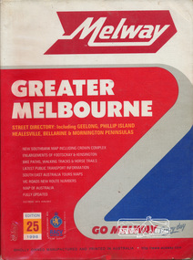
Book, Melway Greater Melbourne street directory : including Geelong, Phillip Island, Healesville, Bellarine & Mornington Peninsulas; Edition 26, 1999, 1999
... Melway Greater Melbourne street directory : including Geelong, Phillip Island, Healesville, Bellarine & Mornington Peninsulas; Edition 26, 1999......melway...Melway Publishing...Melway Publishing...Eltham District Historical Society Inc 728 Main Rd Eltham melbourne streets roads melbourne maps melway Street directory with plastic cover, coloured maps, 772 pages 28 cm x 21.5 cm 1998 Melway Greater Melbourne street directory : including Geelong, Phillip Island, Healesville, Bellarine & Mornington Peninsulas; Edition 26, 1999 Book Melway Publishing Melway Publishing ...Street directory with plastic cover, coloured maps, 772 pages 28 cm x 21.5 cm 1998streets, roads, melbourne, maps, melway -
 Sunshine and District Historical Society Incorporated
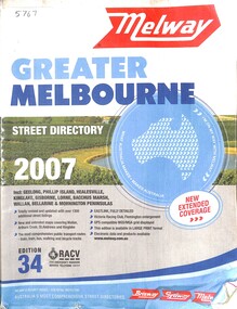
Book - Melway Greater Melbourne Street Directory 2007, Melway Publishing Pty Ltd, 2007
... Melway Greater Melbourne Street Directory 2007...Melway Greater Melbourne Street Directory 2007 Edition 34...Melway Publishing Pty Ltd...Melway Greater Melbourne Street Directory 2007 Edition 34 Paper back book with plastic jacket Melway Greater Melbourne Street Directory 2007 Book Melway Greater Melbourne Street Directory 2007 Melway Publishing Pty Ltd Bob Dodds McPherson's Printing Group ...The series of Melway Directories provides the most comprehensive maps of Great Melbourne area. In this Melway the coverage extends from Wallan, Whittlesea and Kinglake in the North to Mornington Peninsula in the South, Warburton and Tynong in the East to Bacchus Marsh and Geelong in the West. Regional areas of Gisborne, Torquay, Anglesea, Lorne and Phillip Island are also included. Past editions of the Melway can provide invaluable material for researchers and historians.Paper back book with plastic jacketnon-fictionThe series of Melway Directories provides the most comprehensive maps of Great Melbourne area. In this Melway the coverage extends from Wallan, Whittlesea and Kinglake in the North to Mornington Peninsula in the South, Warburton and Tynong in the East to Bacchus Marsh and Geelong in the West. Regional areas of Gisborne, Torquay, Anglesea, Lorne and Phillip Island are also included. Past editions of the Melway can provide invaluable material for researchers and historians. -
 Sunshine and District Historical Society Incorporated
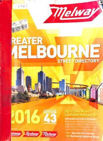
Book - Melway Greater Melbourne Street Directory 2016, Melway Publishing Pty Ltd, 2016
... Melway Greater Melbourne Street Directory 2016...Melway Greater Melbourne Street Directory 2016 Edition 43...Melway Publishing Pty Ltd...Past editions can provide invaluable material for researchers and historians. Melway Greater Melbourne Street Directory 2016 Edition 43 Paper back book Melway Greater Melbourne Street Directory 2016 Book Melway Greater Melbourne Street Directory 2016 Melway Publishing Pty Ltd Crimson Fox Creative Studios Toppan Leefung (Shanghai) Co Ltd Shanghai, China ...The series of Melway Directories provides the most comprehensive maps of Great Melbourne area. In this Melway the coverage extends from Wallan, Whittlesea and Kinglake in the North to Mornington Peninsula in the South, Warburton and Tynong in the East to Bacchus Marsh and Geelong in the West. Regional areas of Kilmore, Macedon, Gisborne, Riddells Creek, Bannockburn, Torquay, Anglesea, Lorne, Phillip Island and Koo Wee Rup are also included. Past editions can provide invaluable material for researchers and historians.Paper back booknon-fictionThe series of Melway Directories provides the most comprehensive maps of Great Melbourne area. In this Melway the coverage extends from Wallan, Whittlesea and Kinglake in the North to Mornington Peninsula in the South, Warburton and Tynong in the East to Bacchus Marsh and Geelong in the West. Regional areas of Kilmore, Macedon, Gisborne, Riddells Creek, Bannockburn, Torquay, Anglesea, Lorne, Phillip Island and Koo Wee Rup are also included. Past editions can provide invaluable material for researchers and historians. -
 Sunshine and District Historical Society Incorporated
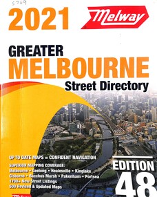
Book - Melway Greater Melbourne Street Directory 2021, Melway Publishing Pty Ltd, 2021
... Melway Greater Melbourne Street Directory 2021...Melway Greater Melbourne Street Directory 2021 Edition 48...Melway Publishing Pty Ltd...Melway Greater Melbourne Street Directory 2021 Edition 48 Paper back book Melway Greater Melbourne Street Directory 2021 Book Melway Greater Melbourne Street Directory 2021 Melway Publishing Pty Ltd Toppan Leefung (Shanghai) Co Ltd Shanghai, China ...The series of Melway Directories provides the most comprehensive maps of Great Melbourne area. In this Melway the coverage extends from Wallan, Whittlesea and Kinglake in the North to Mornington Peninsula in the South, Warburton and Tynong in the East to Bacchus Marsh and Geelong in the West. Regional areas of Kilmore, Macedon, Gisborne, Riddells Creek, Bannockburn, Torquay, Anglesea, Lorne, Phillip Island and Koo Wee Rup are also included. Past editions of the Melway can provide invaluable material for researchers and historians.Paper back booknon-fictionThe series of Melway Directories provides the most comprehensive maps of Great Melbourne area. In this Melway the coverage extends from Wallan, Whittlesea and Kinglake in the North to Mornington Peninsula in the South, Warburton and Tynong in the East to Bacchus Marsh and Geelong in the West. Regional areas of Kilmore, Macedon, Gisborne, Riddells Creek, Bannockburn, Torquay, Anglesea, Lorne, Phillip Island and Koo Wee Rup are also included. Past editions of the Melway can provide invaluable material for researchers and historians. -
 Eltham District Historical Society Inc
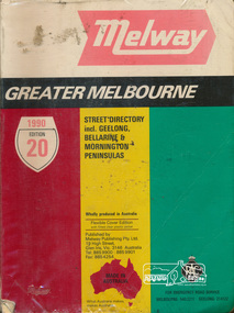
Book, Melway Publishing, Melway Greater Melbourne Street Directory, edition 20, 1990, 1990
... Melway Greater Melbourne Street Directory, edition 20, 1990......melway...Melway Publishing...Melway Greater Melbourne Street Directory, edition 20, 1990 Book Melway Publishing ...Coloured detailed maps accessed by a street or location index.500 p. : col. maps ; Flexible cover edition with fitted clear plastic jacket.ISSN 03113957streets, roads, maps, melway -
 Eltham District Historical Society Inc
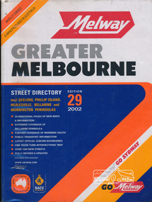
Book, Melway Publishing, Melway Greater Melbourne street directory : including Geelong, Phillip Island, Healesville, Bellarine & Mornington Peninsulas, 2002
... Melway Greater Melbourne street directory : including Geelong, Phillip Island, Healesville, Bellarine & Mornington Peninsulas.......melway...Melway Publishing...Book Melway Publishing ...Edition 29. Coloured detailed maps accessed by a street or location index. Cover: 20 additional pages of new maps, extended coverage of Bellarine Peninsula, further coverage of Werribee South, Public Transport Information, latest official suburb boundaries, CBD "hook turn" intersections map, over 1200 new streets, 1 atlas (24, 886 p.) : col. maps ; ISSN 03113957streets, roads, melbourne, maps, melway -
 Eltham District Historical Society Inc
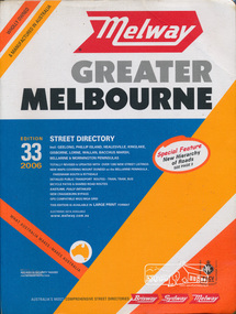
Book, Melway Publishing, Melway Greater Melbourne street directory : including Geelong, Phillip Island, Healesville, Kinglake, Gisborne, Lorne, Wallan, Bacchus Marsh Bellarine & Mornington Peninsulas; Edition 33, 2006, 2005
... Melway Greater Melbourne street directory : including Geelong, Phillip Island, Healesville, Kinglake, Gisborne, Lorne, Wallan, Bacchus Marsh Bellarine & Mornington Peninsulas; Edition 33, 2006...Melway Publishing...Eastlink fully detailed new Craigieburn bypass GPS compatible WGS/MGA Grid Special feature: New Hierachy of Roads streets,roads,melbourne,map,melway Street directory with plastic cover, coloured maps, 902 pages Melway Greater Melbourne street directory : including Geelong, Phillip Island, Healesville, Kinglake, Gisborne, Lorne, Wallan, Bacchus Marsh Bellarine & Mornington Peninsulas; Edition 33, 2006 Book Melway Publishing ...Edition 33. 2006 Coloured detailed maps accessed by a street or location index. Cover: Totally revised and updated with over 1380 new street listings new maps covering Mount Duneed on the Bellarine Peninsula, Pakenham South and Rythdale. Detailed public transport routes - train, tram, bus, bicycle paths & shared road routes. Eastlink fully detailed new Craigieburn bypass GPS compatible WGS/MGA Grid Special feature: New Hierachy of Roads Street directory with plastic cover, coloured maps, 902 pagesstreets,roads,melbourne,map,melway -
 Eltham District Historical Society Inc
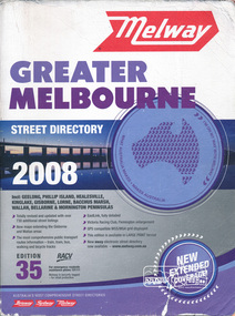
Book, Melway Greater Melbourne street directory 2008 : including Geelong, Phillip Island, Healesville, Kinglake, Gisborne, Lorne, Bacchus March, Wallan, Bellarine & Mornington Peninsulas; Edition 35, 2008, 2007
... Melway Greater Melbourne street directory 2008 : including Geelong, Phillip Island, Healesville, Kinglake, Gisborne, Lorne, Bacchus March, Wallan, Bellarine & Mornington Peninsulas; Edition 35, 2008...Melway Publishing...Eastlink fully detailed, Victoria Racing Club, Flemington enlargement, GPS compatible WGS/MGA Grid displayed, This editon is available in LARGE PRINT format, new eway electronic street directory now available - www.melway.com.au Special feature: New Hierachy of Roads streets,roads,melbourne,map,melway Street directory, coloured maps, indexes, 1201 pages Melway Greater Melbourne street directory 2008 : including Geelong, Phillip Island, Healesville, Kinglake, Gisborne, Lorne, Bacchus March, Wallan, Bellarine & Mornington Peninsulas; Edition 35, 2008 Book Melway Publishing ...Edition 35. 2008 Coloured detailed maps accessed by a street or location index. Cover: Totally revised and updated with over 730 additional street listings, new maps extending the Gisbourne and Wallan areas. The most comprehensive public transport routes information - train, tram, bus, walking and bicycle tracks. Eastlink fully detailed, Victoria Racing Club, Flemington enlargement, GPS compatible WGS/MGA Grid displayed, This editon is available in LARGE PRINT format, new eway electronic street directory now available - www.melway.com.au Special feature: New Hierachy of Roads Street directory, coloured maps, indexes, 1201 pagesstreets,roads,melbourne,map,melway -
 Victorian Aboriginal Corporation for Languages
Book, Melway Publishing, Melway Greater Melbourne street directory : including Geelong, Phillip Island, Healesville, Kinglake, Gisborne, Lorne, Wallan, Bacchus Marsh, Bellarine &? Mornington Peninsulas, 2005
... Melway Greater Melbourne street directory : including Geelong, Phillip Island, Healesville, Kinglake, Gisborne, Lorne, Wallan, Bacchus Marsh, Bellarine &? ...Melway Publishing...Mornington Peninsulas Book Melway Publishing ...Street directory including the wider area surrounding Melbourne.mapsmaps, victorian street maps, street directories, road maps -
 Greensborough Historical Society
Book, Melway Street Directory of Greater Melbourne. Edition 1, 1966_
... Melway Street Directory of Greater Melbourne. ...melway...The directory is accompanied by an outline of the history of the concept and publication of Melway....The directory is accompanied by an outline of the history of the concept and publication of Melway. A surviving first edition of the Melway is rare as these directories are designed to be updated each year. ...The first edition of this iconic Melbourne street directory published in 1966. The directory is accompanied by an outline of the history of the concept and publication of Melway.A surviving first edition of the Melway is rare as these directories are designed to be updated each year. Of interest in this edition is maps of the Greensborough area before large scale subdivision of the land in the late 1960s and 1970s.Soft cover street directory. Coloured maps.189 pages.melway, street directories, melbourne. -
Port Melbourne Historical & Preservation Society
Book - Melway Greater Melbourne Street Directory, Melway, 1990 - 2009
... Four editions of Melway Greater Melbourne Street Directory .01 Edition 20 (1990) - Reg Yellow and green vertical banded cover .02 Edition 24 (1994) - Green, orange, white cover .03 Edition 32 (2005) - Dark and light blue cover .04 Edition 36 (2009) - White, red and black cover...Melway...Port Melbourne Historical & Preservation Society Port Melbourne Town Hall 333 Bay Street Port Melbourne melbourne built environment engineering - roads streets lanes and footpaths natural environment transport - roads melbourne streets mapping Four editions of Melway Greater Melbourne Street Directory .01 Edition 20 (1990) - Reg Yellow and green vertical banded cover .02 Edition 24 (1994) - Green, orange, white cover .03 Edition 32 (2005) - Dark and light blue cover .04 Edition 36 (2009) - White, red and black cover Book Melway Greater Melbourne Street Directory Melway ...Four editions of Melway Greater Melbourne Street Directory .01 Edition 20 (1990) - Reg Yellow and green vertical banded cover .02 Edition 24 (1994) - Green, orange, white cover .03 Edition 32 (2005) - Dark and light blue cover .04 Edition 36 (2009) - White, red and black coverbuilt environment, engineering - roads streets lanes and footpaths, natural environment, transport - roads, melbourne, streets, mapping -
 Greensborough Historical Society
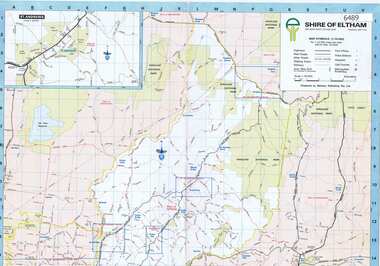
Map, Shire of Eltham, 1990c
... Melway Publishing Pty Ltd...Melway Publishing Pty Ltd...Shire of Eltham Map Melway Publishing Pty Ltd Melway Publishing Pty Ltd ...1:20000 map of Shire of Eltham, with enlargements of a number of areas.Colour map, printed both sides.shire of eltham, eltham -
Melbourne Tram Museum
Map - Metlink folder - Travel Smart Maps, Travelsmart - Department of Infrastructure, "Melbourne's Public transport Map", 2005 to 2006
... Maps published in association with Melway 1 - 5 x 8 fold map with card cover dated Jan 2005 with a price of $2. ......Melway...Maps published in association with Melway 1 - 5 x 8 fold map with card cover dated Jan 2005 with a price of $2. ...Set of four maps issued by Metlink - 2005 to 2006 contained within a Metlank badge plastic folder. Maps published in association with Melway 1 - 5 x 8 fold map with card cover dated Jan 2005 with a price of $2. Detailed map showing rail, tram and bus routes. 2 - 6 x 4 fold map for Moonee Valley - Travelsmart - for public transport, walking and cycling - dated 2005 3 - 7 x 4 fold map for Moreland - Travelsmart - for public transport, walking and cycling - dated October 2006 - includes notes on taxis. 4 - 7 x 4 fold map for Ride to Work day - 5 Oct. 2005Yields information about Melbourne Public Transport network.Metlink plastic folder containing maps.maps, metlink, public transport, moreland, moonee valley, travelsmart -
University of Melbourne, Burnley Campus Archives
Map - Photocopy, Monash University Clayton Campus, 1997
... ...Melway...Photocopy of Map 475 from Melway Street Directory of Monash University, Clayton Campus. ...University of Melbourne, Burnley Campus Archives 500 Yarra Boulevard Richmond melbourne monash university clayton campus Melway Photocopy of Map 475 from Melway Street Directory of Monash University, Clayton Campus. ...Photocopy of Map 475 from Melway Street Directory of Monash University, Clayton Campus. Sections enlarged (4 enlargements)monash university, clayton campus, melway -
 Eltham District Historical Society Inc
Book, Melway Great Melbourne street directory including Geelong, Phillip Island Healesville, Bellarine & Mornington Peninsulas, 1998
... Melway Great Melbourne street directory including Geelong, Phillip Island Healesville, Bellarine & Mornington Peninsulas...Cover: (Includes) New Southbank map including Crown Complex, enlargements of Footscray and Kensington, bike paths, walking tracks & horse trails, latest public transport information, South east Australia tours maps, Vic Roads new route numbers, map of Australia streets maps roads melbourne ISSN 03113957 1 atlas (22, 772 p.) : col. maps ; Melway Great Melbourne street directory including Geelong, Phillip Island Healesville, Bellarine & Mornington Peninsulas Book ...25th edition. Coloured detailed maps accessed by a street or location index. Cover: (Includes) New Southbank map including Crown Complex, enlargements of Footscray and Kensington, bike paths, walking tracks & horse trails, latest public transport information, South east Australia tours maps, Vic Roads new route numbers, map of Australia1 atlas (22, 772 p.) : col. maps ; ISSN 03113957streets, maps, roads, melbourne -
Southern Sherbrooke Historical Society Inc.
Map, "Melway Melbourne Town & Country Wall Map, Municipal Edition 1983", 1983
... "Melway Melbourne Town & Country Wall Map, Municipal Edition 1983"...Southern Sherbrooke Historical Society Inc. 127 Colby Drive Belgrave Heights 3160 yarra-valley-and-the-dandenong-ranges melbourne Wall map showing municipal boundaries prior to 1995 amalgamations. "Melway Melbourne Town & Country Wall Map, Municipal Edition 1983" Map ...Wall map showing municipal boundaries prior to 1995 amalgamations.melbourne -
Port Melbourne Historical & Preservation Society
Document - 2011 Melway Greater Melbourne Street Directory, 2011
... 2011 editions of Melway Greater Melbourne Street Directory Top quarter white, bottom blue background with photo of city...Melway Publishing...Port Melbourne Historical & Preservation Society Port Melbourne Town Hall 333 Bay Street Port Melbourne melbourne built environment engineering - roads streets lanes and footpaths natural environment transport - roads streets mapping greater melbourne 2011 editions of Melway Greater Melbourne Street Directory Top quarter white, bottom blue background with photo of city Document 2011 Melway Greater Melbourne Street Directory Melway Publishing McPherson Printing Group ...2011 editions of Melway Greater Melbourne Street Directory Top quarter white, bottom blue background with photo of citybuilt environment, engineering - roads streets lanes and footpaths, natural environment, transport - roads, streets, mapping, greater melbourne -
 Ringwood and District Historical Society
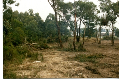
Photographs, Suda and Khassa Ave Ringwood, Before and after Ringwood Bypass Construction 1993
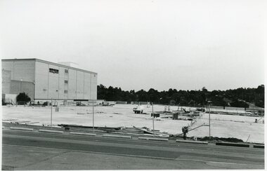
... Also added extract from Melways showing the roads before the Bypass (1987) showing the planned Bypass cutting these two roads, and Melways (2018) showing new alignment with Bypass...Also added extract from Melways showing the roads before the Bypass (1987) showing the planned Bypass cutting these two roads, and Melways (2018) showing new alignment with Bypass Suda and Khassa Ave Ringwood, Before and after Ringwood Bypass Construction 1993 Photographs ...B&W photograph taken by Ringwood Historical Research Group. Also added extract from Melways showing the roads before the Bypass (1987) showing the planned Bypass cutting these two roads, and Melways (2018) showing new alignment with Bypass11063A: 17.1.93 Suda Ave Still intact towards Maroondah Hwy. Taken near Khassa Pde 11063B: 17.1.93 Suda Ave. House gone. Near Khassa Pde 11063C: 17.1.93 Ringwood Bypass from cnr Khassa Pde and Suda Ave towards Mt Dandenong Rd 11063D: 17.2.93 Suda Ave. House gone. 11063E: 21.2.93 cnr Khassa Pde and Suda Ave. Direction of next cut for the Ringwood Bypass. Trees to go. 11063F: 21.2.93 Connection from ??? St to North end of Suda Ave 11063G: 22.2.93 Adelaide St to right (closed). Mile Ave in front and turning left. Note the grey wall along Miles St to support the new car park development. Shrub on left is in the bowling club. -
 Ringwood and District Historical Society
Photographs, Eastland Car park Construction, Ringwood, 1992-93
... Also added extract from Melways showing the roads before the Bypass (1987) showing the planned Bypass cutting these two roads, and Melways (2018) showing new alignment with Bypass...Also added extract from Melways showing the roads before the Bypass (1987) showing the planned Bypass cutting these two roads, and Melways (2018) showing new alignment with Bypass Eastland Car park Construction, Ringwood, 1992-93 Photographs ...B&W photograph taken by Ringwood Historical Research Group. Also added extract from Melways showing the roads before the Bypass (1987) showing the planned Bypass cutting these two roads, and Melways (2018) showing new alignment with Bypass11064A: 21.2.92 Eastland car park development from near Safeway 11064B: 21.2.92 Eastland car park development from Adelaide St 11064C: 4.1.93 Eastland car park development from Warrandyte Road from Op. Bond St. 11064D: 4.1.93 New Myer Eastland car park viewed from Safeway's Roof 11064E: 17.1.93 Eastland car park near where Esso Garage was 11064F: 21.2.92 Eastland car park from cnr of Adelaide St and Eastland -
 Ringwood and District Historical Society
Photograph, Waters Grove, Heathmont - Collection of Photos showing bush damage during construction (Formerly Park St). c1973-5
... This was formerly Park Road (1973 Melways) and Waters Grove from 1974 Melways. ...This was formerly Park Road (1973 Melways) and Waters Grove from 1974 Melways. ...Set of 23 Colour photographs showing bush damage along Waters Grove, Heathmont. Waters Grove runs between Marlborough and Waterloo Streets. This was formerly Park Road (1973 Melways) and Waters Grove from 1974 Melways. Photos are undated, but likely to be around 1974. -
 Whitehorse Historical Society Inc.
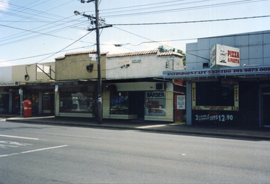
Photograph, Rangeview Shopping Centre, 1998
... Coloured photograph of some of the Rangeview Shopping Centre on the western side of Mitcham Road, Mitcham. Melways 48 K12....Whitehorse Historical Society Inc. 2-10 Deep Creek Road Mitcham melbourne 552 was first grocery run by Mr Clarke.556 was first butcher's shop run by Mr Smith and is still a butcher's shop - Colin Smythe from 1978.Divided into two shops, Alan Evans men's barber and Rangeview Hair Studio. rangeview shopping centre shops shopping centre Coloured photograph of some of the Rangeview Shopping Centre on the western side of Mitcham Road, Mitcham. Melways 48 K12. Rangeview Shopping Centre Photograph Photograph ...552 was first grocery run by Mr Clarke.556 was first butcher's shop run by Mr Smith and is still a butcher's shop - Colin Smythe from 1978.Divided into two shops, Alan Evans men's barber and Rangeview Hair Studio.Coloured photograph of some of the Rangeview Shopping Centre on the western side of Mitcham Road, Mitcham. Melways 48 K12.rangeview shopping centre, shops, shopping centre -
 Melbourne Tram Museum
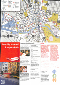
Map, City of Melbourne, "Inner City Transport Map", c1990
... Melbourne City Tourist Shuttle, and two maps, one provided by Melway giving a list of attractions. Published by City of Melbourne, Melway and Metlink with each of their logos....Melbourne City Tourist Shuttle, and two maps, one provided by Melway giving a list of attractions. Published by City of Melbourne, Melway and Metlink with each of their logos. ...Map - 6 fold DL - full colour titled "Inner City Transport Map", providing information for Tourist Information centres, Metlink. Melbourne City Tourist Shuttle, and two maps, one provided by Melway giving a list of attractions. Published by City of Melbourne, Melway and Metlink with each of their logos.trams, tramways, map, public transport, city of melbourne, metlink -
University of Melbourne, Burnley Campus Archives
Map - Photocopy, La Trobe University Bundoora Campus, 2000
... 2 photocopies and 1 enlarged photocopy of map reproduced from Melway Street Directory, Edition 29, of La Trobe University Bundoora Campus....University of Melbourne, Burnley Campus Archives 500 Yarra Boulevard Richmond melbourne la trobe university bundoora campus 2 photocopies and 1 enlarged photocopy of map reproduced from Melway Street Directory, Edition 29, of La Trobe University Bundoora Campus. ...2 photocopies and 1 enlarged photocopy of map reproduced from Melway Street Directory, Edition 29, of La Trobe University Bundoora Campus.la trobe university, bundoora campus -
University of Melbourne, Burnley Campus Archives
Map - Photocopy, University of Melbourne, c. 1999
... Photocopy of enlargement of part of Map 2B, University of Melbourne, Parkville Campus, from Melway Street Directory. On part of page showing Brighton, Hampton, Sandringham, etc....University of Melbourne, Burnley Campus Archives 500 Yarra Boulevard Richmond melbourne university of melbourne parkville campus brighton Hampton Sandringham Melbourne Photocopy of enlargement of part of Map 2B, University of Melbourne, Parkville Campus, from Melway Street Directory. On part of page showing Brighton, Hampton, Sandringham, etc. ...Photocopy of enlargement of part of Map 2B, University of Melbourne, Parkville Campus, from Melway Street Directory. On part of page showing Brighton, Hampton, Sandringham, etc.university of melbourne, parkville campus, brighton, hampton, sandringham, melbourne -
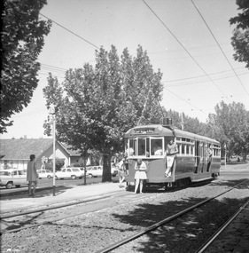 Ballarat Tramway Museum
Photograph - Black & White Photograph/s, 1970's?
... Black and white photograph of L 104 in Dandenong Road Prahran, at tram stop 35 while on a special tour with a signalised intersection behind - Melway shows it as Orrong Road, Prahran. Tram showing destination of "SPECIAL". ...Possibly taken during the mid 1970's - see also item 1314, possibly on the same tour given the hair styles and skirt lengths. See Melway Melbourne Street Directory, 21st edition. ...Black and white photograph of L 104 in Dandenong Road Prahran, at tram stop 35 while on a special tour with a signalised intersection behind - Melway shows it as Orrong Road, Prahran. Tram showing destination of "SPECIAL". Possibly taken during the mid 1970's - see also item 1314, possibly on the same tour given the hair styles and skirt lengths. See Melway Melbourne Street Directory, 21st edition.trams, tramways, l class, dandenong road, melbourne, mmtb, tram 104 -
Victorian Aboriginal Corporation for Languages
Book, City of Whitehorse, City Of Whitehorse parks and reserves: names and origins, 1985
... Alphabetically listed placenames within the local government area, with Melway map points and brief historical references to those places....Alphabetically listed placenames within the local government area, with Melway map points and brief historical references to those places. ...Spiral bound book released by City of Whitehorse council. Alphabetically listed placenames within the local government area, with Melway map points and brief historical references to those places.Black and white photographs, colour photographsplace names, city of whitehorse, box hill, mitcham, mont albert, blackburn, surrey hills, burwood, nunawading, forest hill -
University of Melbourne, Burnley Campus Archives
Map, City of Kew, Hyde Park, c. 1970
... Scale 1 inch:40 ft. (2) Map 45 from Melway with Hyde Park highlighted....Scale 1 inch:40 ft. (2) Map 45 from Melway with Hyde Park highlighted. City of Kew, Hyde Park Map ...(1) Photocopy of hand drawn plan of park showing contours. No 7/3. Scale 1 inch:40 ft. (2) Map 45 from Melway with Hyde Park highlighted.kew, hyde park -
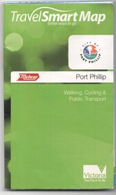 Melbourne Tram Museum
Document, Ministry of Transport, "Travel Smart Map - Port Phillip", 2010
... Map - pocket - 28 fold - showing walking, cycling and public transport in the City of Port Phillip, using a Melway Map base along with public transport information, Metcard, cycling and walking groups....Yields information about Port Phillip transport and other services in 2010 tramways Melbourne Tram services bus services Railways Port Phillip cyclists Map - pocket - 28 fold - showing walking, cycling and public transport in the City of Port Phillip, using a Melway Map base along with public transport information, Metcard, cycling and walking groups. ...Gives extensive details of walking cycling Public Transport in Port Phillip. Printed 2010. Yields information about Port Phillip transport and other services in 2010Map - pocket - 28 fold - showing walking, cycling and public transport in the City of Port Phillip, using a Melway Map base along with public transport information, Metcard, cycling and walking groups.tramways, melbourne, tram services, bus services, railways, port phillip, cyclists -
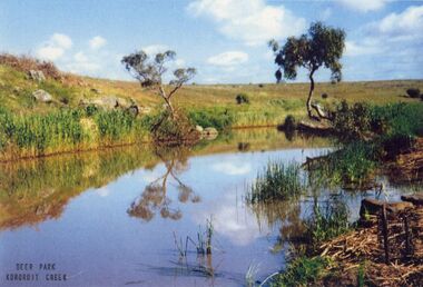 Sunshine and District Historical Society Incorporated
Photograph - Kororoit Creek, Johnson, Des, 1993
... Photographs of a pool in Kororoit Creek near Adnamira Court Deer Park Original photo taken by Des Johnson Melway map 25 A3...Kororoit Creek Deer Park Adnamira Court Photographs of a pool in Kororoit Creek near Adnamira Court Deer Park Original photo taken by Des Johnson Melway map 25 A3 Kororoit Creek Photograph Kororoit Creek Johnson, Des ...Photographs of a pool in Kororoit Creek near Adnamira Court Deer Park Original photo taken by Des Johnson Melway map 25 A3kororoit creek, deer park, adnamira court