Eltham District Historical Society Inc
Photograph - Aerial Photograph, Landata, Lower Plenty, Feb. 1956
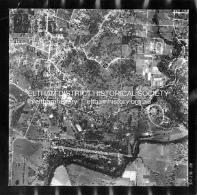
... ...Melway 21E10...Historic Aerial Imagery
Source: Landata.vic.gov.au
Aerial Photo Details:
Project No :250
Project : MELBOURNE OUTER SUBURBS PROJECT
Run : 17
Frame : 116
Date : 02/1956
Film Type : B/W
Camera : EAG9
Flying Height : 10000
Scale : 12000
Film Number : 1176
GDA2020 : 37°43'58"S, 145°07'49"E
MGA2020 : 335237, 5822186 (55)
Melways : 21 E10 (ed. 42) Aerial Photo 1956-02 Neil Webster Collection Eltham Main Road Bonds Road Elham Lower Plenty Melway 21E10 Pitt Street Yarra River Digital jpg and electronic PDF file Lower Plenty Photograph Aerial Photograph Landata ...
Centred on present day 217 Old Eltham Road, Lower Plenty bounded by Pitt Street to north, Yarra River to south, Main Road to east and Bonds Road to west.
Historic Aerial Imagery
Source: Landata.vic.gov.au
Aerial Photo Details:
Project No :250
Project : MELBOURNE OUTER SUBURBS PROJECT
Run : 17
Frame : 116
Date : 02/1956
Film Type : B/W
Camera : EAG9
Flying Height : 10000
Scale : 12000
Film Number : 1176
GDA2020 : 37°43'58"S, 145°07'49"E
MGA2020 : 335237, 5822186 (55)
Melways : 21 E10 (ed. 42)aerial photo, 1956-02, neil webster collection, eltham, main road, bonds road, elham, lower plenty, melway 21e10, pitt street, yarra river