Eltham District Historical Society Inc
Photograph - Aerial Photograph, Landata, Eltham, Vic, Jan. 1951
... ...Melway 22B3...Historic Aerial Imagery
Source: Landata.vic.gov.au
Aerial Photo Details:
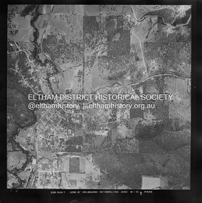
Project No :65
Project : MELBOURNE AND METROPOLITAN PROJECT NO. 2
Run : 7
Frame : 9
Date : 01/1951
Film Type : B/W
Camera : EAG9
Flying Height : 12200
Scale : 12000
Film Number : 1419
GDA2020 : 37°42'23"S, 145°09'39"E
MGA2020 : 337874, 5825170 (55)
Melways : 22 B3 (ed. 42) Historical aerial photos and photo maps provide viusal evidence of the chronology of changes to the built landscape of the district and assist in dating other images Aerial Photo 1951-01 Eltham Neil Webster Collection Arthur Street Beard Street Catholic Ladies College frank street Main Road Maroondah Aqueduct Maroong Drive Melway 22B3 Research (Vic.) Digital jpg and electronic PDF file Eltham, Vic. ...
Centred on Beard Street between Main Road and Frank Street, Eltham bounded by Maroondah Aqueduct to north, Arthur Street to south, Maroong Drive to east and Catholic Ladies College to west.
Historic Aerial Imagery
Source: Landata.vic.gov.au
Aerial Photo Details:
Project No :65
Project : MELBOURNE AND METROPOLITAN PROJECT NO. 2
Run : 7
Frame : 9
Date : 01/1951
Film Type : B/W
Camera : EAG9
Flying Height : 12200
Scale : 12000
Film Number : 1419
GDA2020 : 37°42'23"S, 145°09'39"E
MGA2020 : 337874, 5825170 (55)
Melways : 22 B3 (ed. 42)Historical aerial photos and photo maps provide viusal evidence of the chronology of changes to the built landscape of the district and assist in dating other imagesaerial photo, 1951-01, eltham, neil webster collection, arthur street, beard street, catholic ladies college, frank street, main road, maroondah aqueduct, maroong drive, melway 22b3, research (vic.)
 Eltham District Historical Society Inc
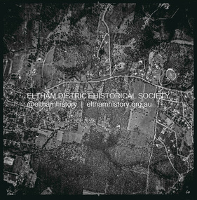 Eltham District Historical Society Inc