Eltham District Historical Society Inc
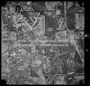
Photograph - Aerial Photograph, Landata, Eltham, Feb. 1956
... ...Melway 22B8...Historic Aerial Imagery
Source: Landata.vic.gov.au
Aerial Photo Details:
Project No :250
Project : MELBOURNE OUTER SUBURBS PROJECT
Run : 18
Frame : 92
Date : 02/1956
Film Type : B/W
Camera : EAG9
Flying Height : 10000
Scale : 12000
Film Number : 1176
GDA2020 : 37°43'35"S, 145°09'31"E
MGA2020 : 337735, 5822959 (55)
Melways : 22 B8 (ed. 42) Aerial Photo 1956-02 Neil Webster Collection Eltham Brougham Steet Culla Hill Eltham Lower Park Hohnes Road Melway 22B8 Monckton Road Mount Pleasant Road Petty's Orchard Reynolds Road Sweeneys Lane Templestowe Yarra River Digital jpg and electronic PDF file Eltham Photograph Aerial Photograph Landata ...
Centred on present day Culla Hill and Petty's Orchard, Eltham bounded by Brougham Street and Mount Pleasant Road to north, Monckton Road, Templestowe to south, Reynolds Road to east and Eltham Lower Park and Hohnes Road to west.
Historic Aerial Imagery
Source: Landata.vic.gov.au
Aerial Photo Details:
Project No :250
Project : MELBOURNE OUTER SUBURBS PROJECT
Run : 18
Frame : 92
Date : 02/1956
Film Type : B/W
Camera : EAG9
Flying Height : 10000
Scale : 12000
Film Number : 1176
GDA2020 : 37°43'35"S, 145°09'31"E
MGA2020 : 337735, 5822959 (55)
Melways : 22 B8 (ed. 42)aerial photo, 1956-02, neil webster collection, eltham, brougham steet, culla hill, eltham lower park, hohnes road, melway 22b8, monckton road, mount pleasant road, petty's orchard, reynolds road, sweeneys lane, templestowe, yarra river
 Eltham District Historical Society Inc
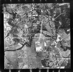 Eltham District Historical Society Inc