Showing 5 items matching "millbank road"
-
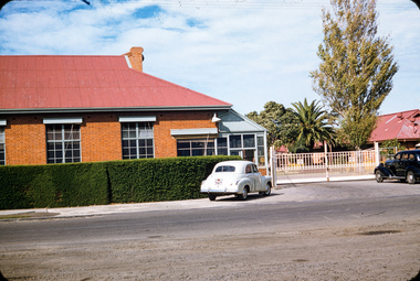 Sunshine and District Historical Society Incorporated
Slide - Darcy Worcester Photograph Collection, Darcy Worcester, C1955 & 1956
... ...Millbank Road...Macedon Cross Station Road Ballarat Road Millbank Road Deer Park Melbourne Mt. Macedon Mt. ...ICI Deer Park was one of the most important industrial sites in Victoria, the birthplace of Australia’s commercial explosives industry and later a major chemicals, plastics, and fertiliser hub. The factory operated from 1875 until the early 2000s and shaped the entire civic, employment, and suburban landscape of Deer Park, Sunshine, St Albans, and the western suburbs. Darcy Worcester, an ICI employee was a keen photographer. He took many photographs around Melbourne when he was working for ICI during 1955 and 1956. These photographs provide a rare glimpse of the ICI Factory, Deer Park and other locations in Melbourne and Victoria during the mid 1950's5893.01 - Darcy Worcester Photograph Collection - ICI Factory Station Road Entrance Deer Park.jpg 5893.02 - Darcy Worcester Photograph Collection - ICI Factory Deer Park Looking Towards Mess Room.jpg 5893.03 - Darcy Worcester Photograph Collection - ICI Factory Deer Park West Side.jpg 5893.04 - Darcy Worcester Photograph Collection - ICI Factory Deer Park West Side.jpg 5893.05 - Darcy Worcester Photograph Collection - ICI Factory Deer Park West Side.jpg 5893.06 - Darcy Worcester Photograph Collection - ICI Factory Deer Park East Side.jpg 5893.07 - Darcy Worcester Photograph Collection - ICI Oil Store And Cooling Tower From South East.jpg 5893.08 - Darcy Worcester Photograph Collection - ICI Calander Section.jpg 5893.09 - Darcy Worcester Photograph Collection - ICI Factory Witton Street From John McLeod Reserve.jpg 5893.10 - Darcy Worcester Photograph Collection - ICI Factory Picnic Races Maddingley Park Bacchus Marsh.jpg 5893.11 - Darcy Worcester Photograph Collection - ICI Housing Estate Deer Park.jpg 5893.12 - Darcy Worcester Photograph Collection - View Towards ICI Housing Estate Deer Park.jpg 5893.13 - Darcy Worcester Photograph Collection - Deer Park Kindergarten Millbank Drive Cnr Station Road.jpg This kindergarten was built by voluntary labour. 5893.14 - Darcy Worcester Photograph Collection - ICI Recreation Club Entrance Ballarat Road.jpg 5893.15 - Darcy Worcester Photograph Collection - ICI Recreation Club Rear Ballarat Road.jpg 5893.16 - Darcy Worcester Photograph Collection - Exhibition Gardens Melbourne.jpg 5893.17 - Darcy Worcester Photograph Collection - Exhibition Building Melbourne.jpg 5893.18 - Darcy Worcester Photograph Collection - Entrance To Government House Melbourne.jpg 5893.19 - Darcy Worcester Photograph Collection - Approach To Shrine Of Remembrance Melbourne.jpg 5893.20 - Darcy Worcester Photograph Collection - Shrine Of Remembrance Melbourne.jpg 5893.21 - Darcy Worcester Photograph Collection - View From Top Shrine Of Remembrance Melbourne Government House Side.jpg 5893.22 - Darcy Worcester Photograph Collection - View From Top Shrine Of Remembrance Melbourne Looking North West.jpg 5893.23 - Darcy Worcester Photograph Collection - View From Top Shrine Of Remembrance Melbourne Looking South.jpg 5893.24 - Darcy Worcester Photograph Collection - View From Top Shrine Of Remembrance Melbourne Looking West.jpg 5893.25 - Darcy Worcester Photograph Collection - View From Top Shrine Of Remembrance Melbourne Looking North.jpg 5893.26 - Darcy Worcester Photograph Collection - Flinders Street Station Flinders Street Cnr Swanston Street Melbourne.jpg 5893.27 - Darcy Worcester Photograph Collection - Old House In Melbourne East.jpg 5893.28 - Darcy Worcester Photograph Collection - Pt. Londsale.jpg 5893.29 - Darcy Worcester Photograph Collection - Unlabelled.jpg 5893.30 - Darcy Worcester Photograph Collection - Botanical Gardens Melbourne.jpg 5893.31 - Darcy Worcester Photograph Collection - Derrimut Farm.jpg 5893.32 - Darcy Worcester Photograph Collection - Derrimut Farm.jpg 5893.33 - Darcy Worcester Photograph Collection - Derrimut Farm.jpg 5893.34 - Darcy Worcester Photograph Collection - Mt. Macedon Cross.jpg 5893.35 - Darcy Worcester Photograph Collection - Unlabelled.jpg 5893.36 - Darcy Worcester Photograph Collection - Unlabelled.jpgici, deer park kindergarten, ici recreation club, exhibition gardens, exhibition building, government house, shrine of remembrance, flinders street station, mt. derrimut farm, mt. macedon cross, station road, ballarat road, millbank road, deer park, melbourne, mt. macedon, mt. derriut, derrimut -
![Map, Millbank Estate Bacchus Marsh Thursday 4th October 1888 [Land sales], 1924](/media/collectors/5e461d8021ea67224c82f2a1/items/67765662eb6d2cbd24e0797f/item-media/67765682eb6d2cbd24e07a41/item-fit-380x285.jpg?cb=6) Bacchus Marsh & District Historical Society
Bacchus Marsh & District Historical SocietyMap, Millbank Estate Bacchus Marsh Thursday 4th October 1888 [Land sales], 1924
... (Main Street), Maddingley Road (now Grant Street), Turner Street, Millbank Street, Clarinda Road (now Clarinda Street), and an unnamed street south of Turner Street (possibly known as Grant Street at this time) which connected to Maddingley Road through the vicinity of the present day Bacchus Marsh Hospital. ... (Main Street), Maddingley Road (now Grant Street), Turner Street, Millbank Street, Clarinda Road (now Clarinda Street), and an unnamed street south of Turner Street (possibly known as Grant Street at this time) which connected to Maddingley Road through the vicinity of the present day Bacchus Marsh Hospital. ...The Millbank Estate was a parcel of land close to the centre of the shopping area of Bacchus Marsh which was sub-divided and offered for sale in 62? lots on the 4th October 1888. The lots had frontages to Ballarat Road (Main Street), Maddingley Road (now Grant Street), Turner Street, Millbank Street, Clarinda Road (now Clarinda Street), and an unnamed street south of Turner Street (possibly known as Grant Street at this time) which connected to Maddingley Road through the vicinity of the present day Bacchus Marsh Hospital. This was a significant sub-division of land and represented a major expansion of residential housing in Bacchus Marsh in the late 19th century. The map includes a wealth of detail about the time of the sale, where it will take place, who the selling agents were, the deposit terms for purchases and details of a special train from Melbourne to Bacchus Marsh on sale day. The location of the allotments in relation to the shopping and commercial area of Bacchus Marsh, Maddingley and the railway station are indicated on an inset map within the overall map and poster. The Millbank Estate area was an area which had once belonged to the Grant family who were prominent early citizens of Bacchus Marsh and lived in a house in this area known as 'Millbank'.This land sale map is a typical example of housing estate land sales advertising maps produced by real estate agents in this era. The map is significant for the detailed information it provides about when and where land was sold for new housing estates in Bacchus Marsh in the late nineteenth century.Single page map showing land allotments for sale at auction in Bacchus Marsh in October 1888. A significant portion of the map is missing from the bottom right side. land sales bacchus marsh, land subdivsion bacchus marsh, housing estates land sales bacchus marsh, grant family bacchus marsh, millbank estate land sales -
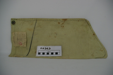 Frankston RSL Sub Branch
Bag, Water Filter
... Frankston RSL Sub Branch 183 Cranbourne Road Frankston mornington-peninsula The bag is imprinted with the following: 'CAT No A.F.005' and has a square box imprint with 'M&Co.(N) ^ 1945'. Single person water filter bag used by World War 2 service personnel to obtain clear water when in the field. This filter type is known as a "Millbank ...Single person water filter bag used by World War 2 service personnel to obtain clear water when in the field. This filter type is known as a "Millbank Filter". The filter is in the form of a light green canvas bag shaped like a sock and is designed to collect and filter particles and parasites from groundwater, etc. The canvas is of a fine weave which allows the water to filter slowly from inside the bag. The top of the filter bag has brass eyelets set on opposite sides for hanging from a tree or other point during water filtering. On one side of the bag has been stamped in permanent black ink 'CAT No A.F.0005' and 'M&Co.(N) BROAD ARROW 1945'. A cotton label has been sewn near the bag top with a printed six step instruction list for use of the filter bag. Below this is a line marked in permanent black marker to let the user know when to start collecting the water draining from the bag.The bag is imprinted with the following: 'CAT No A.F.005' and has a square box imprint with 'M&Co.(N) ^ 1945'. -
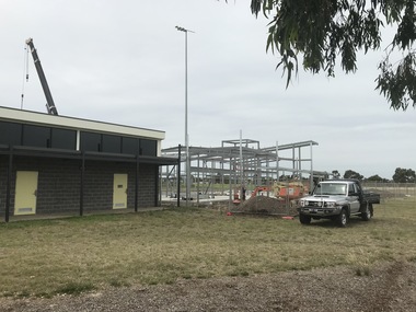 Sunshine and District Historical Society Incorporated
Photograph - Deer Park Photographs 2021, John Alchin, 2021
... Road...Deer Park Hall...Millbank...Deer Park Bon Thomas Reserve Ballarat Road Deer Park Club Deer Park Fire Station Deer Park Football Club Station Road Deer Park Hall Millbank Drive Deer Park Play Group Deer Park Post Office Deer Park Railway Station Dumfries Street John McLeod Reserve Air Raid Shelter Leathercloth Factory Opie's Farm Porter Court Robert Bruce Reserve Sassella Park St. ...These photographs provide a visual record of assorted buildings, street views, and notable locations throughout Deer Park in 2021.This photograph collection documents Deer Park in 2021.5653.01 - Bon Thomas Reserve 2021 Photo 04.JPG 5653.02 - Bon Thomas Reserve 2021 Photo 01.JPG 5653.03 - Deer Park Avenue of Honour Ballarat Rd 2021 Photo 01.JPG 5653.04 - Deer Park Club 2021 Photo 02.JPG 5653.05 - Deer Park Club 2021 Photo 04.JPG 5653.06 - Deer Park Fire Station 782 Ballarat Rd Deer Park 2021 Photo 01.JPG 5653.07 - Deer Park Football Club Rooms 2021 Photo 02.JPG 5653.08 - Deer Park Football Club Rooms 2021 Photo 04.JPG 5653.09 - Deer Park Hall Station Rd Deer Park 2021 Photo 01.JPG 5653.10 - Deer Park Play Group Centre Millbank Drive Deer Park 2021 Photo 01.JPG 5653.11 - Deer Park Post Office Ballarat Rd 2021 Photo 01.JPG 5653.12 - Deer Park Railway Station 2021 Photo 01.JPG 5653.13 - Dumfries St 73 - 77 Deer Park - Shops 2021 Photo 02.JPG 5653.14 - Dumfries St 73 - 77 Deer Park - Shops 2021 Photo 03.JPG 5653.15 - John McLeod Reserve WW2 Air Raid Shelter 2021 Photo 06.JPG 5653.16 - Leathercloth Factory Station Rd Deer Park 2021 Photo 01.JPG 5653.17 - Opie's Farm Deer Park 2021 Photo 01.JPG 5653.18 - Opie's Farm Deer Park 2021 Photo 03.JPG 5653.19 - Opie's Farm Deer Park 2021 Photo 12.JPG 5653.20 - Opie's Farm Deer Park 2021 Photo 05.JPG 5653.21 - Opie's Farm Deer Park 2021 Photo 09.JPG 5653.22 - Opie's Farm Deer Park 2021 Photo 15.JPG 5653.23 - Porter Crt 1 Deer Park - Shops 2021 Photo 01.JPG 5653.24 - Robert Bruce Reserve Deer Park 2021 Photo 02.JPG 5653.25 - Sassella Park Station Rd - Significant Tree Sugar Gum 2021 Photo 01.JPG 5653.26 - St. John Anglican Church Gates 2021 Photo 01.JPG 5653.27 - Station Rd 51 Deer Park 2021 Photo 01.JPG 5653.28 - Station Rd 75 Deer Park - Thai's Hairdressing Salon 2021 Photo 01.JPG 5653.29 - Station Rd 85 And 85A Deer Park - Shop 2021 Photo 01.JPG 5653.30 - Station Rd 93 Deer Park 2021 Photo 01.JPG 5653.31 - Station Rd 100 - 104 Deer Park - Medical Centre And Chemist 2021 Photo 01.JPG 5653.32 - Steel Works Glencairn Ave 2021 Photo 01.JPG 5653.33 - The Hunt Club Main Hall Way 2021 Photo 01.JPG 5653.34 - The Hunt Club Back Stained Glass Window 2021 Photo 10.JPG 5653.35 - The Hunt Club Balcony 2021 Photo 15 5653.36 - The Hunt Club Art Gallery 2021 Photo 17.JPGdeer park, bon thomas reserve, ballarat road, deer park club, deer park fire station, deer park football club, station road, deer park hall, millbank drive, deer park play group, deer park post office, deer park railway station, dumfries street, john mcleod reserve, air raid shelter, leathercloth factory, opie's farm, porter court, robert bruce reserve, sassella park, st. john anglican church, the hunt club, deer park medical centre, deer park avenue of honour -
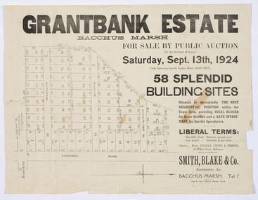 Bacchus Marsh & District Historical Society
Map - Land Sales Plan, Grantbank Estate Bacchus Marsh, 1924
... It comprised an area of 15 acres, being a portion of the Millbank Estate which had been in the hands of the Grant family for 75 years. The lots had frontages to Gisborne Road, Patterson, William and Sutherland Streets. ...It comprised an area of 15 acres, being a portion of the Millbank Estate which had been in the hands of the Grant family for 75 years. The lots had frontages to Gisborne Road, Patterson, William and Sutherland Streets. ...The Grantbank Estate was a parcel of land close to the centre of the shopping area of Bacchus Marsh which was sub-divided and offered for sale in 58 lots on the 13th September, 1924. It comprised an area of 15 acres, being a portion of the Millbank Estate which had been in the hands of the Grant family for 75 years. The lots had frontages to Gisborne Road, Patterson, William and Sutherland Streets. This was a significant sub-division of land and represented a major expansion of residential housing in Bacchus Marsh in the early 20th century.This land sale map is a typical example of housing estate land sales advertising maps produced by real estate agents in this era. The map is significant for the detailed information it provides about when and where land was sold for new housing estates in Bacchus Marsh in the early twentieth century.Printed paper mapland sales bacchus marsh, land subdivsion bacchus marsh, housing estates land sales bacchus marsh, grant family bacchus marsh