Showing 799 items matching "mine plan"
-
 Bendigo Historical Society Inc.
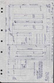
Document - CENTRAL DEBORAH GOLD MINE - PLAN OF CHANGING HOUSE
... CENTRAL DEBORAH GOLD MINE - PLAN OF CHANGING HOUSE...Mine... Plan of Changing House... Information . Ref. Mines Dept. Surface Plan 15/1/1954. Written by A Richardson 14/12/1971....History House 11 Mackenzie Street Bendigo goldfields MINE Gold central deborah gold mine Central Deborah Gold Mine Plan of Changing House A Richardson Mines Dept. ...Hand drawn plan for Changing House for Central Deborah G. M. Co. Bendigo. Drawn by A. Richardson 14/11/1971. Drawing has approx. measurements and is not drawn to scale. Also some Central Deborah Gold Mine Information . Ref. Mines Dept. Surface Plan 15/1/1954. Written by A Richardson 14/12/1971.mine, gold, central deborah gold mine, central deborah gold mine, plan of changing house, a richardson, mines dept. surface plan 15/1/1954 -
 Bendigo Historical Society Inc.
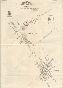
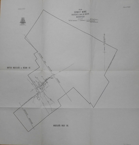
Map - COMET MINE - PLAN OF COMET MINE
... COMET MINE - PLAN OF COMET MINE...... Comet Mine Plan Bulletin No 33 Plate No XXIV...Plan of the Comet Mine on the Hustler's Line of Reefs Bulletin No 33, Plate No XXIV signed by H S Whitelaw, Underground Survey Office Bendigo, September 1913. ...Depths shown. Map COMET MINE - PLAN OF COMET MINE ...Plan of the Comet Mine on the Hustler's Line of Reefs Bulletin No 33, Plate No XXIV signed by H S Whitelaw, Underground Survey Office Bendigo, September 1913. Upper and Lower Levels and approximate boundaries shown. Depths shown.Geological Survey of Victoriamining, parish map, hustler's line of reefs, comet mine plan bulletin no 33 plate no xxiv -
 Bendigo Historical Society Inc.
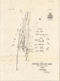
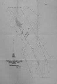
Map - FORTUNA HUSTLER'S MINE - PLAN OF THE FORTUNA HUSTLER'S MINE
... FORTUNA HUSTLER'S MINE - PLAN OF THE FORTUNA HUSTLER'S MINE...Mine... Plan of the Fortuna Hustler's Mine...Plan of the Fortuna Hustler's Mine, Bulletin No 33, Plate No II. ...Map FORTUNA HUSTLER'S MINE - PLAN OF THE FORTUNA HUSTLER'S MINE ...Plan of the Fortuna Hustler's Mine, Bulletin No 33, Plate No II. Geological Survey of Victoria. Signed by H A Whitelaw, Underground Survey Office Bendigo, September 1913. Map shows levels and depths. There are smaller drawings of some sections of some levels. mining, parish map, fortuna hustler's mine, plan of the fortuna hustler's mine, geological survey of victoria, h a whitelaw, underground survey office bendigo -
 Bendigo Historical Society Inc.
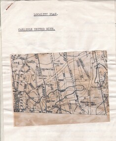
Document - CARLISLE UNITED MINE - LOCALITY PLAN
... CARLISLE UNITED MINE - LOCALITY PLAN... Carlisle United Mine Locality Plan....Document CARLISLE UNITED MINE - LOCALITY PLAN ...2 typed foolscap copies of notes on the Carlisle United mine on the Garden Gully Line of Reef. One has 10.5 x 14 cm map attached to the front. Notes are the same as 3501.1 notes.mine, gold, carlisle united, carlisle united mine, carlisle united mine locality plan. -
 Bendigo Historical Society Inc.
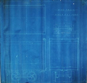
Plan - Mine Truck Plan, 19th December, 1917
... Mine Truck Plan...Written on top of plan 'Mine Truck Plan' and '3" equals 1 ft'. Specifications for truck annotated on plan. ...Plan forms part of the Margaret Roberts Collection. Plan Mine Truck Plan ...Blue wax paper plan, with black text. Written on top of plan 'Mine Truck Plan' and '3" equals 1 ft'. Specifications for truck annotated on plan. Plan forms part of the Margaret Roberts Collection.gold mining, gold, bendigo, whip and jersey, mine truck, specifications -
 Bendigo Historical Society Inc.
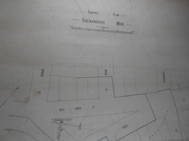
Administrative record - Shenandoah Mine Surface plan
... Shenandoah Mine Surface plan...Draftsman's drawing Shenandoah Mine Surface Plan Map. Forms part of the Margaret Roberts Collection of mining records....Administrative record Shenandoah Mine Surface plan ...Draftsman's drawing Shenandoah Mine Surface Plan Map. Forms part of the Margaret Roberts Collection of mining records.bendigo, margaret roberts, gold, map, mine, shendandoah mine -
 Bendigo Historical Society Inc.
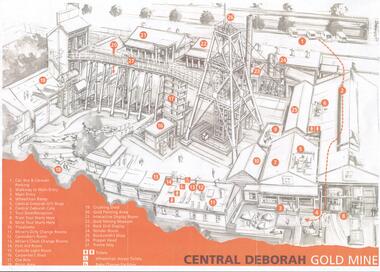
Document - CENTRAL DEBORAH GOLD MINE: PLAN OF SURFACE FEATURES OF MINE
... CENTRAL DEBORAH GOLD MINE: PLAN OF SURFACE FEATURES OF MINE...Two copies of a plan of the Central Deborah Gold Mine. Features on the surface of the mine are drawn, labelled and described. ...Document CENTRAL DEBORAH GOLD MINE: PLAN OF SURFACE FEATURES OF MINE ...BHS CollectionTwo copies of a plan of the Central Deborah Gold Mine. Features on the surface of the mine are drawn, labelled and described. Plan printed in orange and grey.bendigo, mining, central deborah gold mine -
 Bendigo Historical Society Inc.
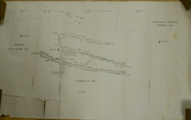
Document - MARKS COLLECTION: LANSELL'S 180 MINE PLAN
... MARKS COLLECTION: LANSELL'S 180 MINE PLAN...Document MARKS COLLECTION: LANSELL'S 180 MINE PLAN ...Plan on heavy parchment paper. Printed on bottom of plan 'Lansell's 180 plan' On top RH corner 'Victoria Quartz Mining Co' On LH side 'North Old Chum Co' Plan shows rock formation e.g. quartz lava slide. Plan found in documents from George Lansell auction, donated by Phillipa Marks.bendigo, mining, lansell's 180 mine -
 Bendigo Historical Society Inc.
Map - FORTUNA HUSTLER'S MINE - PLAN OF FORTUNA HUSTLER'S MINE
... FORTUNA HUSTLER'S MINE - PLAN OF FORTUNA HUSTLER'S MINE...Map and plan of the Fortuna Hustler's Mine on the Hustler's Line of Reefs. ...Map FORTUNA HUSTLER'S MINE - PLAN OF FORTUNA HUSTLER'S MINE ...Map and plan of the Fortuna Hustler's Mine on the Hustler's Line of Reefs. Bulletin No 33, Plate No 1. Plan gives depth of the different levels. Bendigo Railway Station is on the map and also a number of the streets. Carpenter Street is called Cemetery Road. Also on the Hustler's Line of Reef is the Summer Hill Shaft. Shown is the Hustler's Royal Reserve No 2 Lease. Map has the Geological Survey of Victoria crest. It is signed by H Whit ? an Underground Survey Office Bendigo, September 1913. map, fortuna hustler's mine, hustler's royal reserve no 2 lease, summer hill shaft, hustler's line of reef -
 Bendigo Historical Society Inc.
Map - COMET MINE - PLAN OF COMET MINE
... COMET MINE - PLAN OF COMET MINE...Plan of the Comet Mine on the Hustler's Line of Reefs Bulletin No 33, Plate No XXIII. ...United Hustler's & Redan Co and Hustler's Reef Co also named on map. Map COMET MINE - PLAN OF COMET MINE ...Plan of the Comet Mine on the Hustler's Line of Reefs Bulletin No 33, Plate No XXIII. Map shows depths, Lightning Hill Anticline, Hustler's Anticline and approximate Lease Boundary. Signed by H. S. Whitelaw, Underground Survey Office Bendigo, September 1913. United Hustler's & Redan Co and Hustler's Reef Co also named on map. Geological Survey of Victoriamining, hustler's line of reefs, comet line plan belletin no 33 plate no xxiii, lightning hill anticline, hustler's anticline, united hustler's & redan co, hustler's reef co, h s whitelaw -
 Bendigo Historical Society Inc.
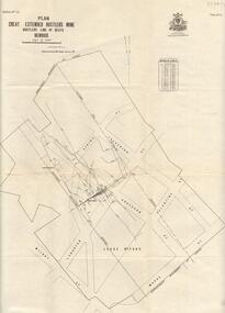
Map - GREAT EXTENDED HUSTLER'S MINE - PLAN OF THE GREAT EXTENDED HUSTLER'S MINE
... GREAT EXTENDED HUSTLER'S MINE - PLAN OF THE GREAT EXTENDED HUSTLER'S MINE...Plan of the Great Extended Hustler's Mine. Bulletin No 33, Plate No XI. ...Map GREAT EXTENDED HUSTLER'S MINE - PLAN OF THE GREAT EXTENDED HUSTLER'S MINE ...Plan of the Great Extended Hustler's Mine. Bulletin No 33, Plate No XI. Shows No 2 Shaft, Latham & Watson's Shaft, levels and their depths and some geographical features. Geographical Survey of Victoria emblem and signed by H A Whitelaw, Underground Survey Office, Bendigo, September 1913. Has reference to photos.mining, parish map, great extended hustler's mine, no 2 shaft, latham & watson's shaft, geological survey of victoria, underground survey office bendigo, h a whitelaw -
 Bendigo Historical Society Inc.
Map - GREAT EXTENDED HUSTLER'S MINE - PLAN OF THE GREAT EXTENDED HUSTLER'S MINE
... GREAT EXTENDED HUSTLER'S MINE - PLAN OF THE GREAT EXTENDED HUSTLER'S MINE...Plan of the Great Extended Hustler's Mine on the Hustler's Line of Reefs, Bendigo. ...Map GREAT EXTENDED HUSTLER'S MINE - PLAN OF THE GREAT EXTENDED HUSTLER'S MINE ...Plan of the Great Extended Hustler's Mine on the Hustler's Line of Reefs, Bendigo. Bulletin No 33, Plate No X. Lease No 7382. Plan has map of streets. Mine was located in the block bounded by Langston and Anderson Streets and was between the Hustler's Anticline at Surface and the Lightning Hill Anticline at Surface. Latham & Watson's Shaft is also mentioned. Levels are numbered and a table shows the Levels and their Depths. Geological Survey of Victoria. Signed by H A Whitelaw, Underground Survey Office, Bendigo, September 1913. This item has not been scanned or photographed.mining, parish map, great extended hustler's mine, hustler's line of reefs, mining lease no 7382, geological survey of victoria, underground survey office bendigo, h a whitelaw, latham & watson's shaft -
 Bendigo Historical Society Inc.
Map - HUSTLER'S ROYAL RESERVE NO 2 MINE - PLAN OF THE HUSTLER'S ROYAL RESERVE NO 2 MINE
... HUSTLER'S ROYAL RESERVE NO 2 MINE - PLAN OF THE HUSTLER'S ROYAL RESERVE NO 2 MINE...Plan of the Hustler's Royal Reserve No 2 Mine on the Hustler's Line of Reefs Bulletin No 33, Plate No VI. ...Map HUSTLER'S ROYAL RESERVE NO 2 MINE - PLAN OF THE HUSTLER'S ROYAL RESERVE NO 2 MINE ...Plan of the Hustler's Royal Reserve No 2 Mine on the Hustler's Line of Reefs Bulletin No 33, Plate No VI. Boundary of Leases No 8898 and 8897 shown. Various levels shown and some geographical features. Geological Survey of Victoria emblem. H . Harman, Director, W. Dickson, Secretary for Mines and The Hon. J. Drysdale Brown, Minister of Mines and signed by H Whitdon, Underground Survey Office, Bendigo, September 1913. mining, parish map, hustler's royal reserve no 2 mine, hustler's line of reefs, geological survey of victoria, h herman, w dickson, the hon j drysdale brown mlc -
 Bendigo Historical Society Inc.
Map - HUSTLER'S ROYAL RESERVE NO 2 MINE - PLAN OF THE HUSTLER'S ROYAL RESERVE NO 2 MINE
... HUSTLER'S ROYAL RESERVE NO 2 MINE - PLAN OF THE HUSTLER'S ROYAL RESERVE NO 2 MINE...Plan of the Hustler's Royal Reserve No 2 Mine Bulletin No 33, Plate No V. ...Map HUSTLER'S ROYAL RESERVE NO 2 MINE - PLAN OF THE HUSTLER'S ROYAL RESERVE NO 2 MINE ...Plan of the Hustler's Royal Reserve No 2 Mine Bulletin No 33, Plate No V. Plan shows the Hustler's Royal Reserve No 2 (Main Shaft), Hustler's Royal Reserve No 2 (Park Shaft.), the Royal Hustler's, the Imperial Hustler's and the Extended Hustler's Freehold on the Hustler's Line of Reefs. Also mentioned is the Lightning Hill Line of Reefs. Map shows some of the levels, approximate boundary of lease and the boundary of Lease No 8892 and 8897. There are also street names and the locations of jail, lagoons, Post Office, Rosalind Park and the State School, High School and Continuation School. Geological Survey of Victoria emblem. H. Herman Director, W. Dickson, Secretary of Mines and The Hon. J. Drysdale Brown MLC, Minister of Mines. Signed by zh Whitdan, Underground Survey Office, Bendigo, September 1913.mining, parish map, hustler's royal reserve no 2 mine, royal hustler's, imperial hustler's, extended hustler's freehold, geological survey of victoria, h herman, w dickson, the hon j drysdale brown, h whitdan, hustler's line of reefs, lightning hill line of reefs -
 Stawell Historical Society Inc
Archive, Stawell Gold Mine, Stawell Gold Mine Emergency Plan, 1/08/2015
... Stawell Gold Mine Emergency Plan...Plans produced by Mine for Emergency use showing ventilation & Emergency Exits Plans and Conatacts....Mining Gold Date of Issue 31/ 08/2015 Uncontrolled Copy Ring Bound A3 book with laminated Covers & Black and Yellow Banding for attention Stawell Gold Mine Emergency Plan Archive Stawell Gold Mine ...Plans produced by Mine for Emergency use showing ventilation & Emergency Exits Plans and Conatacts.Ring Bound A3 book with laminated Covers & Black and Yellow Banding for attentionDate of Issue 31/ 08/2015 Uncontrolled Copymining, gold -
Stawell Historical Society Inc
Map, Gold Mines of Australia, Stawell Investment Geological Plan. Mine Area showing Mineshafts
... Stawell Investment Geological Plan. Mine Area showing Mineshafts. ...Stawell Historical Society Inc 46 Longfield St Stawell grampians mining gold map Gold Mines of Australia Ltd The Reefs Mine shaft locations Stawell Investment Geological Plan. Mine Area showing Mineshafts. ...The Reefs Mine shaft locationsGold Mines of Australia Ltd mining, gold, map -
Stawell Historical Society Inc
Map, Stawell Joint Venture, Mine Site Detail Plan, September 1989
... Mine Site Detail Plan ...Stawell Historical Society Inc 46 Longfield St Stawell grampians mining gold map 1989 Mine Site Detail Plan Map Stawell Joint Venture ...1989mining, gold, map -
Stawell Historical Society Inc
Map, Gold Mines of Australia, Geological Plan Wonga Mine Area Stawell Investigation, 1950
... Geological Plan Wonga Mine Area Stawell Investigation...Stawell Historical Society Inc 46 Longfield St Stawell grampians mining gold map Gold Mines of Australia Ltd Plans Showing Stawell Investment 1950 Geological Plan Wonga Mine Area Stawell Investigation Map Gold Mines of Australia ...Plans Showing Stawell Investment 1950Gold Mines of Australia Ltd mining, gold, map -
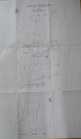
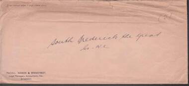 Bendigo Historical Society Inc.
Document - MCCOLL, RANKIN AND STANISTREET COLLECTION: SOUTH FREDERICK THE GREAT CO NL, 1934
... ...gold mine...Plan...Plan of Residence Areas on No. 10287, by J O Charlton, Parish of Yarraberb. Includes land for school, owners names of blocks, crown land. Signed: Garnet G Birch. Dated 27/4/1935, licensed surveyor. b/ Letter from Department of Mines...History House 11 Mackenzie Street Bendigo goldfields ORGANIZATION Business gold mine Plan Of Area For On Lease No. 10287 Ben. ...McColl Rankin & Stanistreet, South Frederick the Great Co NL. a/ Plan of Residence Areas on No. 10287, by J O Charlton, Parish of Yarraberb. Includes land for school, owners names of blocks, crown land. Signed: Garnet G Birch. Dated 27/4/1935, licensed surveyor. b/ Letter from Department of Mines to McColl Rankin & Stanistreet in reference to letter regarding lease No. 10287. On back of letter are notes relating to blocks of land on lease No.10287. c/ Plan Of Area For On Lease No. 10287 Ben. By John O Charlton. Mining District of Bendigo, Parish of Yarraberb, Lease No. 10287 Ben. By John O Charlton. Mining District of Bendigo. Date 21/6/1934. Signed Garnet G Birch. Blocks include name of purchaser. d/ Plan Of Area For On Lease No. 10287 Ben. By John O Charlton. Mining District of Bendigo, Parish of Yarraberb, County of Bendigo. Dated 21/6/1934. e/ envelope inscribed South Fredrick the Great. 51.organization, business, gold mine, plan of area for on lease no. 10287 ben. by john o charlton. mining district of bendigo, parish of yarraberb, county of bendigo j o charlton garnet g birch department of mines lease no. 10287 ben. by john o charlton mining district of bendigo 1934 -
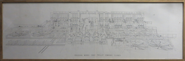 Federation University Historical Collection
Plan, Crushing Works, Port Phillip Company
... port phillip mine...plan...Barker Library (top floor) Mount Helen goldfields Detailed mechanical engineering drawing of the Port Phillip Company Crushing Works at Clunes, Victoria port phillip mine plan rivett henry bland clunes crushing works mechanical engineering Plaque: "Donated to the Metallurgy Department of Ballarat University College by noted Ballarat Author and Historian, A W Strange. 13/6/91" Framed plan of the Port Phillip Company's crushing works. ...Detailed mechanical engineering drawing of the Port Phillip Company Crushing Works at Clunes, VictoriaFramed plan of the Port Phillip Company's crushing works. Plaque: "Donated to the Metallurgy Department of Ballarat University College by noted Ballarat Author and Historian, A W Strange. 13/6/91" port phillip mine, plan, rivett henry bland, clunes, crushing works, mechanical engineering -
Clunes Museum
Document - PLAN, ADAMS FREEHOLD AND ADJACENT MINING PROPERTIES
... ...MINE PLAN...Clunes Museum 36 Fraser Street enter building through Collins Place Clunes goldfields LOCAL HISTORY DOCUMENT MINE PLAN MINING PLANS J.WEARE PLAN SHOWING ADAM'S FREEHOLD AND ADJACENT MINING PROPERTIES. ...PLAN SHOWING ADAM'S FREEHOLD AND ADJACENT MINING PROPERTIES.J.WEARElocal history, document, mine plan, mining, plans -
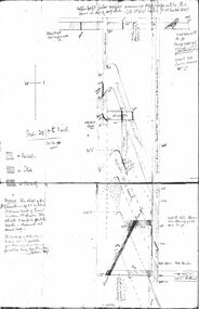 Bendigo Historical Society Inc.
Document - CHRISTMAS REEF GOLD MINING CO. COLLECTION: PLAN OF MINE
... CHRISTMAS REEF GOLD MINING CO. COLLECTION: PLAN OF MINE...Hand drawn plan of mine, showing spurs, slate, lava. Christmas Reef shaft and Great Western shaft drawn. ...Document CHRISTMAS REEF GOLD MINING CO. COLLECTION: PLAN OF MINE ...Hand drawn plan of mine, showing spurs, slate, lava. Christmas Reef shaft and Great Western shaft drawn. Notations in pencil. On left hand side 'Memo: the shaft of the Christmas Reef Co is about 5 chains north of Great Western Cos shaft. The strata and surface pitch north, assumed at same rate. The working of Allingham and Moore's Trib Co are taken from their reports in Bendigo Advertiser May 1872 to May 1873. Jas Down Mgr' Scale on plan 20 ft to 1 inch Legend shows sandstone, slate and quartz.Bendigo Advertiserbendigo, mining, christmas reef gold mining -
Federation University Historical Collection
Document - Report, Ballarat School of Mines Planning Document for Meeting with the Minister for Education the Hon. Ian Cathie, M.P., 1986, 06/06/1986
... Ballarat School of Mines planning document for a meeting with the minister for education....Barker Library (top floor) Mount Helen goldfields ballarat school of mines planning document ian cathie minister for education Ballarat School of Mines planning document for a meeting with the minister for education. ...Ballarat School of Mines planning document for a meeting with the minister for education.ballarat school of mines, planning document, ian cathie, minister for education -
Federation University Historical Collection
Report, Ballarat School of Mines Planning Document for Meeting with the Minister for Education the Hon. Robert Fordham, M.P., 1983, 16/09/1983
... Ballarat School of Mines planning document for a meeting with the minister for education....Barker Library (top floor) Mount Helen goldfields ballarat school of mines planning document minister for education robert fordham Ballarat School of Mines planning document for a meeting with the minister for education. ...Ballarat School of Mines planning document for a meeting with the minister for education.ballarat school of mines, planning document, minister for education, robert fordham -
Federation University Historical Collection
Booklet, The Creation of a Centre For Regional Development, 1979, 06/1979
... Ballarat School of Mines planning proposal. Planning document 13.79...Barker Library (top floor) Mount Helen goldfields Ballarat School of Mines Regional Development centre for regional development Ballarat School of Mines planning proposal. Planning document 13.79 The Creation of a Centre For Regional Development, 1979 Booklet ...Ballarat School of Mines planning proposal. Planning document 13.79ballarat school of mines, regional development, centre for regional development -
Bendigo Historical Society Inc.
Plan - Oswald Gold Mine
... Oswald Gold Mine Plan forms part of the Margaret Roberts Collection....This highly successful mine, managed by Robert Dent Oswald, was a major quartz-mining site in the late 19th century. gold mining gold Bendigo North Hustlers New Hustlers Hustlers Hill Oswald Gold Mine Plan forms part of the Margaret Roberts Collection. ...The Oswald Gold Mine, often referred to as the North British Mine, was located approximately 2 kilometres south-east of the town of Maldon in central Victoria, Australia. It was situated on Parkins Reef Road, running south from Mount Tarrangower. This highly successful mine, managed by Robert Dent Oswald, was a major quartz-mining site in the late 19th century. Oswald Gold Mine Plan forms part of the Margaret Roberts Collection.gold mining, gold, bendigo, north hustlers, new hustlers, hustlers hill -
Bendigo Historical Society Inc.
Plan - Shamrock Gold Mine
... Shamrock Gold Mine Plan forms part of the Margaret Roberts Collection....The Shamrock Mine was located in between Old High Street and High Street, Golden Square, not far from the former fire station building. gold mining gold Bendigo Shamrock Gold Mine Golden Square High Street Shamrock Gold Mine Plan forms part of the Margaret Roberts Collection. ...The Shamrock Mine was located in between Old High Street and High Street, Golden Square, not far from the former fire station building.Shamrock Gold Mine Plan forms part of the Margaret Roberts Collection.gold mining, gold, bendigo, shamrock gold mine, golden square, high street -
Bendigo Historical Society Inc.
Plan - Goldfields Consolidated Mine
... Goldfields Consolidated Mine Plan forms part of the Margaret Roberts Collection....Goldfields Consolidated Mine Plan forms part of the Margaret Roberts Collection. ...Napoleon Reefs Gold Mine was located off Harvey Street, Ironbark, Bendigo. Goldfields Consolidated Mine Plan forms part of the Margaret Roberts Collection.gold mining, gold, bendigo, ironbark, goldfields consolidated mine, naoleon goldfields co. -
Bendigo Historical Society Inc.
Plan - VIRGINIA CONSOLS MINE
... Virginia Consols Mine Plan forms part of the Margaret Roberts Collection....Virginia Consols Gold Mine was located on Virginia Hill, Eaglehawk. gold mining gold Bendigo Virginia Consols Mine Virginia Hill Eaglehawk Virginia Consols Mine Plan forms part of the Margaret Roberts Collection. ...Virginia Consols Gold Mine was located on Virginia Hill, Eaglehawk.Virginia Consols Mine Plan forms part of the Margaret Roberts Collection.gold mining, gold, bendigo, virginia consols mine, virginia hill, eaglehawk -
Bendigo Historical Society Inc.
Plan - East Clarence Gold Mine
... East Clarence Gold Mine Plan forms part of the Margaret Roberts Collection....History House 11 Mackenzie Street Bendigo goldfields gold mining gold Sheepshead reef Red White and Blue East Clarence Gold Mine Plan forms part of the Margaret Roberts Collection. ...East Clarence Gold Mine Plan forms part of the Margaret Roberts Collection.gold mining, gold, sheepshead reef, red white and blue