Showing 208 items matching "mining and township"
-
 Ringwood and District Historical Society
Literary work - Envelope, Packet: Percydale - small mining township - history written by Betty Austin of Ringwood (June 1966)
... Packet: Percydale - small mining township - history written by Betty Austin of Ringwood (June 1966)...Percydale - small mining township - history written by Betty Austin, Kendall Street Ringwood...Ringwood and District Historical Society 125A Warrandyte Road Ringwood North melbourne Percydale - small mining township - history written by Betty Austin, Kendall Street Ringwood Packet: Percydale - small mining township - history written by Betty Austin of Ringwood (June 1966) Literary work Envelope ...Percydale - small mining township - history written by Betty Austin, Kendall Street Ringwood -
 Ringwood and District Historical Society
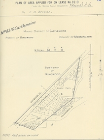
Map, Department of Mines, Plan of area applied for under the mining leases regulations in the township of Ringwood between Maroondah Highway and Mt. Dandenong Road. Mining District of Castlemaine, County of Mornington, Parish of Ringwood T Area 58(A) 2 (R)15(P) Acres, Roods, Perches. 1934, 20-Feb-34
... Plan of area applied for under the mining leases regulations in the township of Ringwood between Maroondah Highway and Mt. ...Buff coloured sheet foolscap with black printing showing map of the township of Ringwood between Maroondah Highway and Mt. ...Plan of area applied for under the mining leases regulations in the township of Ringwood between Maroondah Highway and Mt. ...Map of the township of Ringwood with subdivisions between Maroondah Highway and Mt. Dandenong Road. the area applied for on lease No.8210 by E.G.Browne.Mining District of Castlemaine, County of Mornington, Parish of Ringwood T Area 58(A) 2 (R)15(P) Acres, Roods, Perches.Buff coloured sheet foolscap with black printing showing map of the township of Ringwood between Maroondah Highway and Mt. Dandenong Road. Mining District of Castlemaine, County of Mornington, Parish of Ringwood T Area 58(A) 2 (R)15(P) Acres, Roods, Perches +Additional Keywords: Browne E.G. -
Stawell Historical Society Inc
Map, Stawell Gold Mines, Stawell Township proposed Town zoning showing Special Uses ( Mining) 1998, 1998
... Stawell Township proposed Town zoning showing Special Uses ( Mining) 1998...Stawell Historical Society Inc 46 Longfield St Stawell grampians Shows Mining activity Stockpiles Tracks, Plant, Dams, Waste heap, Tailing Dams, Ironbarks Mining Stawell Gold Mines Pty Ltd Date April 1998 Map Printed in Colour with Coloured Legend Stawell Township proposed Town zoning showing Special Uses ( Mining) 1998 Map Stawell Gold Mines ...Shows Mining activity Stockpiles Tracks, Plant, Dams, Waste heap, Tailing Dams, IronbarksMap Printed in Colour with Coloured LegendStawell Gold Mines Pty Ltd Date April 1998mining -
Stawell Historical Society Inc
Map, Stawell Gold Mine, Stawell Gold Mine Photo Map of Stawell Township showing Underground Declines in mining lease, 2007
... Stawell Gold Mine Photo Map of Stawell Township showing Underground Declines in mining lease....Stawell Gold Mine Photo Map of Stawell Township showing Underground Declines in mining lease. ...SGM photo Map 2007 Produced for Public Consultation over Big Hill Open Pit Proposal. Aerial Views Stawellmining, gold, map -
Clunes Museum
Photograph, CLUNES IN THE 1860'S
... CRITERION. QUARTZ MINING COMPANY REGISTERED CLUNES VIEW IN TOWNSHIP, CLUNES, SOUTH EAST CAMP PARDE, CLUNES, SOUTH WEST PORT PHILLIP AND COLONIAL GOLD MINING COMPANY, CLUNES VICTORIAN QUARTZ MINING COMPANY, REGISTERED CLUNES...PUBLISHED BY SHIRE OF TALBOT AND CLUNES FROM ORIGINAL PHOTOGRAPHS. .2 PHOTO PRINT - VIEW IN TOWNSHIP, CLUNES, SOUTH EAST .3 PHOTO PRINT - CAMP PARADE, CLUNES, SOUTH WEST .4 PHOTO PRINT - PORT PHILLIP AND COLONIAL GOLD MINING COMPANY, CLUNES .5 PHOTO PRINT - VICTORIA QUARTZ MINING COMPANY, REGISTERED, CLUNES .6 PHOTO PRINT - CRITERION QUARTZ MINING COMPANY, REGISTERED. ...Clunes Museum 36 Fraser Street enter building through Collins Place Clunes goldfields CRITERION. QUARTZ MINING COMPANY REGISTERED CLUNES VIEW IN TOWNSHIP, CLUNES, SOUTH EAST CAMP PARDE, CLUNES, SOUTH WEST PORT PHILLIP AND COLONIAL GOLD MINING COMPANY, CLUNES VICTORIAN QUARTZ MINING COMPANY, REGISTERED CLUNES LOCAL HISTORY PHOTOGRAPHY PHOTOGRAPHS MINING CLUNES IN THE 1860'S FIVE VIEWS BY CHARLES NETTLEFOLD C. ...CRITERION. QUARTZ MINING COMPANY REGISTERED CLUNES VIEW IN TOWNSHIP, CLUNES, SOUTH EAST CAMP PARDE, CLUNES, SOUTH WEST PORT PHILLIP AND COLONIAL GOLD MINING COMPANY, CLUNES VICTORIAN QUARTZ MINING COMPANY, REGISTERED CLUNESCLUNES IN THE 1860S FIVE VIEWS BY CHARLES NETTLETON .1 LARGE ENVELOPE WITH DESCRIPTIONS OF EACH OF THE PHOTOS. PUBLISHED BY SHIRE OF TALBOT AND CLUNES FROM ORIGINAL PHOTOGRAPHS. .2 PHOTO PRINT - VIEW IN TOWNSHIP, CLUNES, SOUTH EAST .3 PHOTO PRINT - CAMP PARADE, CLUNES, SOUTH WEST .4 PHOTO PRINT - PORT PHILLIP AND COLONIAL GOLD MINING COMPANY, CLUNES .5 PHOTO PRINT - VICTORIA QUARTZ MINING COMPANY, REGISTERED, CLUNES .6 PHOTO PRINT - CRITERION QUARTZ MINING COMPANY, REGISTERED. CLUNESC. NETTLEFOLD, PHOTO, MELBOURNElocal history, photography, photographs, mining, clunes in the 1860's five views by charles nettlefold -
 Ballarat Heritage Services
Photograph - Image - Black and White, Ballarat From Black Hill, 1888, 1888
... Image of a mining site on Black Hill, with the township of Ballarat in the background. ...Ballarat Heritage Services PO Box 2209 Bakery Hill Post Office goldfields black hill mining poppett head black hill flat Image of a mining site on Black Hill, with the township of Ballarat in the background. ...Image of a mining site on Black Hill, with the township of Ballarat in the background. black hill, mining, poppett head, black hill flat -
Stawell Historical Society Inc
Map, Township of Stawell Photo Map, 1947
... Photograph of Stawell from Air Circa 1947. Shows mining sites and township...Shows mining sites and township Township of Stawell Photo Map Map ...Photograph of Stawell from Air Circa 1947. Shows mining sites and townshipmining, gold, map -
 Bendigo Historical Society Inc.
Slide - DIGGERS & MINING. DIGGERS AND MINERS, 1850s
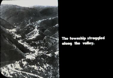
... Diggers & Mining. Diggers and Miners. The township struggled along the valley. ...History House 11 Mackenzie Street Bendigo goldfields EDUCATION Tertiary goldfields hanimount Diggers & Mining. Diggers and Miners. The township struggled along the valley. ...Diggers & Mining. Diggers and Miners. The township struggled along the valley. Photo shows the township along the valley. Markings: 46 994.5 WAL. Used as a teaching aid.hanimounteducation, tertiary, goldfields -
 Federation University Art Collection
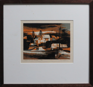
Work on paper - Artwork - Printmaking, Jack, Kenneth, 'Long Gully near Bendigo' Kenneth Jack, 1960
... Framed Limited Edition print showing a mining township at Long Gully, Bendigo. Donated through the Australian Gifts Programme by Katherine Littlewood....Federation University Art Collection Artworks are displayed at Federation University Australia campuses at Ballarat, Gippsland (Churchill), Stawell and Horsham. goldfields goldfields poppet head bendigo long gully tram 29/40 Framed Limited Edition print showing a mining township at Long Gully, Bendigo. Donated through the Australian Gifts Programme by Katherine Littlewood. ...Framed Limited Edition print showing a mining township at Long Gully, Bendigo. Donated through the Australian Gifts Programme by Katherine Littlewood.29/40goldfields, poppet head, bendigo, long gully, tram -
 Ringwood and District Historical Society
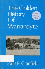
Book, The Golden History of Warrandyte - Louis R. Cranfield
... History of more than a 100 years from the earliest days of the discovery of gold and the setting up of a mining camp through to the transition of becoming a thriving township...Ringwood and District Historical Society 125A Warrandyte Road Ringwood North melbourne History of more than a 100 years from the earliest days of the discovery of gold and the setting up of a mining camp through to the transition of becoming a thriving township The Golden History of Warrandyte - Louis R. ...History of more than a 100 years from the earliest days of the discovery of gold and the setting up of a mining camp through to the transition of becoming a thriving township -
 Ringwood and District Historical Society
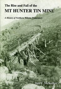
Book, The Rise and Fall of the Mt Hunter Tin Mine - A History of Northern Wilsons Promontory - Ian C. McKellar, 1993
... Green soft covered 46-page book with maps, photographs and inclusion of references to Wilsons Promontory National Park and plans for the township of Seaforth, mining and timber....Ringwood and District Historical Society 125A Warrandyte Road Ringwood North melbourne Green soft covered 46-page book with maps, photographs and inclusion of references to Wilsons Promontory National Park and plans for the township of Seaforth, mining and timber. The Rise and Fall of the Mt Hunter Tin Mine - A History of Northern Wilsons Promontory - Ian C. ...Green soft covered 46-page book with maps, photographs and inclusion of references to Wilsons Promontory National Park and plans for the township of Seaforth, mining and timber. -
 Bendigo Historical Society Inc.
Document - LONG GULLY HISTORY GROUP COLLECTION: PRESS RELEASE
... Copy of a two page press release mentioning the placement of an information marker to acknowledge the achievement that underground mining made to Bendigo. It was felt that Long Gully was the ideal location for a marker as not only was the Long Gully township an underground mining centre it is also close to being geographically the centre of the Bendigo deep mining field....History House 11 Mackenzie Street Bendigo goldfields BHS Collection BENDIGO History long gully history group The Long Gully History Group - Press Release The Long Gully History Group The Cornish Association The City of Greater Bendigo Long Gully Community House Copy of a two page press release mentioning the placement of an information marker to acknowledge the achievement that underground mining made to Bendigo. It was felt that Long Gully was the ideal location for a marker as not only was the Long Gully township an underground mining centre it is also close to being geographically the centre of the Bendigo deep mining field. ...BHS CollectionCopy of a two page press release mentioning the placement of an information marker to acknowledge the achievement that underground mining made to Bendigo. It was felt that Long Gully was the ideal location for a marker as not only was the Long Gully township an underground mining centre it is also close to being geographically the centre of the Bendigo deep mining field.bendigo, history, long gully history group, the long gully history group - press release, the long gully history group, the cornish association, the city of greater bendigo, long gully community house -
 Rutherglen Historical Society
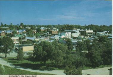
Post Card Folder, Nucolorvue Productions Pty Ltd, Big 7 Folder, Vue Pac. 7 Detachable Post Cards of Rutherglen Victoria, c1970
... On message side of card: "Rutherglen Victoria. Rutherglen township which was first established in the 1880's in the boom years of gold mining, is now the heart of a wine industry. | NCV.1047 Nucolorvue Productions Pty Ltd."...Rutherglen township which was first established in the 1880's in the boom years of gold mining, is now the heart of a wine industry. | NCV.1047 Nucolorvue Productions Pty Ltd." ...Donated by Mrs Brian Jasper.Coloured post cards in folder with views of Rutherglen and District. This one is a view of Rutherglen Township.On message side of card: "Rutherglen Victoria. Rutherglen township which was first established in the 1880's in the boom years of gold mining, is now the heart of a wine industry. | NCV.1047 Nucolorvue Productions Pty Ltd."rutherglen township -
Clunes Museum
Photograph - LITHOGRAPH PRINT
... LITHOGRAPH OF A SCETCH OF PORT PHILIP MINING COMPANY AND THE TOWNSHIP OF CLUNES WITH FRASER STREET IN THE FRONT ORIGINAL PHOTOGRAPH TAKEN FROM THE HILL BEHIND THE OLD LIBRARY IN TEMPLETON STREET ...Clunes Museum 36 Fraser Street enter building through Collins Place Clunes goldfields THIS PHOTOGRAPH WOULD HAVE BEEN TAKEN PRIOR TO THE FIRESWHICH DESTROYED THE ORIGINAL SHOPS IN FRASER STREET CLUNES 1869 PORT PHILIPMINE GEOFFREY BLAINEY LITHOGRAPH OF MINE TOWNSHIP OF CLUNES 1869 HANDSIGNED BY GEOFFREY BLAINEY - 17/3/2001 LITHOGRAPH OF A SCETCH OF PORT PHILIP MINING COMPANY AND THE TOWNSHIP OF CLUNES WITH FRASER STREET IN THE FRONT ORIGINAL PHOTOGRAPH TAKEN FROM THE HILL BEHIND THE OLD LIBRARY IN TEMPLETON STREET Photograph LITHOGRAPH PRINT ...THIS PHOTOGRAPH WOULD HAVE BEEN TAKEN PRIOR TO THE FIRESWHICH DESTROYED THE ORIGINAL SHOPS IN FRASER STREETLITHOGRAPH OF A SCETCH OF PORT PHILIP MINING COMPANY AND THE TOWNSHIP OF CLUNES WITH FRASER STREET IN THE FRONT ORIGINAL PHOTOGRAPH TAKEN FROM THE HILL BEHIND THE OLD LIBRARY IN TEMPLETON STREET TOWNSHIP OF CLUNES 1869 HANDSIGNED BY GEOFFREY BLAINEY - 17/3/2001clunes 1869 port philipmine, geoffrey blainey, lithograph of mine -
 Bendigo Historical Society Inc.
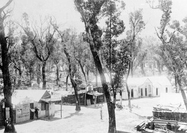
Drawing - MINING IN BENDIGO COLLECTION: SKETCH OF MINING AREA
... Pen and ink sketch of a mining scene. Sketch shows poppet legs and mine buildings, overhead mine structures, railway, township, miners cottages in a bush setting. ...History House 11 Mackenzie Street Bendigo goldfields ART Mining in Bendigo Sketch of Mining Area Pen and ink sketch of a mining scene. ...Pen and ink sketch of a mining scene. Sketch shows poppet legs and mine buildings, overhead mine structures, railway, township, miners cottages in a bush setting. Artist unknownart, mining in bendigo, sketch of mining area -
Clunes Museum
Photograph - PHOTOGRAPHS, VIEW IN TOWNSHIP, CLUNES, SOUTH EAST
... Five reproduced black and white images of Clunes and surrounds; Camp Parade, Clunes South West View in Township, Clunes South East Port Phillip and Colonial Goldmining Company Victoria Quartz Mining Company Registered, Clunes Criterion Quartz Mining Company Registered Clunes ...Clunes Museum 36 Fraser Street enter building through Collins Place Clunes goldfields CLUNES TOWNSHIP CLUNES MINES Five reproduced black and white images of Clunes and surrounds; Camp Parade, Clunes South West View in Township, Clunes South East Port Phillip and Colonial Goldmining Company Victoria Quartz Mining Company Registered, Clunes Criterion Quartz Mining Company Registered Clunes VIEW IN TOWNSHIP, CLUNES, SOUTH EAST Photograph PHOTOGRAPHS ...Five reproduced black and white images of Clunes and surrounds; Camp Parade, Clunes South West View in Township, Clunes South East Port Phillip and Colonial Goldmining Company Victoria Quartz Mining Company Registered, Clunes Criterion Quartz Mining Company Registered Clunes clunes township, clunes mines -
 Stawell Historical Society Inc
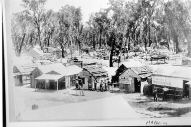
Photograph, Mafeking Goldfield at Mt William with Businesses in the township c1900
... Mafeking Goldfield Mt William Mining Scene c1900. Businesses in the township....Stawell Historical Society Inc 46 Longfield St Stawell grampians Mafeking Goldfield Mt William Mining Scene c1900. Businesses in the township. ...Mafeking Goldfield Mt William Mining Scene c1900. Businesses in the township.stawell -
 Bendigo Historical Society Inc.
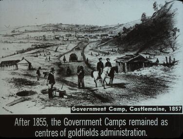
Slide - DIGGERS & MINING. THE GOLD LICENCE, c1857
... After 1855, the Government Camps remained as centres of goldfields administration. Slide shows mining at Castlemaine in the background you can see buildings that could be the start of the Castlemaine township. ...After 1855, the Government Camps remained as centres of goldfields administration. Slide shows mining at Castlemaine in the background you can see buildings that could be the start of the Castlemaine township. ...Diggers & Mining. The gold licence. The Government Camp. Government Camp, Castlemaine, 1857. After 1855, the Government Camps remained as centres of goldfields administration. Slide shows mining at Castlemaine in the background you can see buildings that could be the start of the Castlemaine township. Markings: 44 994.LIF. 4. Used as a teaching aid.hanimounteducation, tertiary, goldfields -
 Federation University Historical Collection
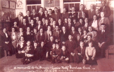
Photograph, A memento of the dance and euchre party Durham Lead 13.5.38
... Durham Lead (also known as Durham, 1870s) was a mining township 15 km south of Ballarat. It was one of several mining centres along the main mining lead running south of Ballarat, generally along the valley formed by the Yarowee or Leigh River...Barker Library (top floor) Mount Helen goldfields Durham Lead (also known as Durham, 1870s) was a mining township 15 km south of Ballarat. It was one of several mining centres along the main mining lead running south of Ballarat, generally along the valley formed by the Yarowee or Leigh River durham lead leigh river garibaldi gold A memento of the dance and euchre party Durham Lead 13.5.38 Copy of a sepia tone black and white photograph of a large group of men, women and children taken at the dance and euchre party Durham Lead 13 April 1938. ...Durham Lead (also known as Durham, 1870s) was a mining township 15 km south of Ballarat. It was one of several mining centres along the main mining lead running south of Ballarat, generally along the valley formed by the Yarowee or Leigh RiverCopy of a sepia tone black and white photograph of a large group of men, women and children taken at the dance and euchre party Durham Lead 13 April 1938. Front row sitting on the seat (not the floor):- 4th from left, Mrs. Minnie Scott (nee Kinsey); 5th from left, Miss Lucy Kinsey; 1st right, Mr Thomas Scott Jnr. (dark suit & tie) 2nd back row:- 7th lady from right, wearing glasses, slightly behind, Miss Catherine (Kit) Scott A memento of the dance and euchre party Durham Lead 13.5.38durham lead, leigh river, garibaldi, gold -
 Bendigo Historical Society Inc.
Slide - DIGGERS & MINING. DIGGERS AND MINERS, c1850s
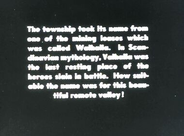
... The township took it's name from one of the mining leases which was called Walhalla. ...The township took it's name from one of the mining leases which was called Walhalla. ...Diggers & Mining. Diggers and miners. Walhalla - Gold Town. The township took it's name from one of the mining leases which was called Walhalla. In Scandinavian mythology, Valhalla was the last resting place of the heroes slain in battle. How suitable the name was for this beautiful remote valley! Markings: 14 995 WAL. Used as a teaching aid.hanimounteducation, tertiary, goldfields -
 Stawell Historical Society Inc
Photograph, Mafeking Goldfield at Mt William with Photographer, Hairdresser and other buildings c1900
... Mafeking Goldfield Mt William Mining Scene c1900. Businesses in township. ...Stawell Historical Society Inc 46 Longfield St Stawell grampians Mafeking Goldfield Mt William Mining Scene c1900. Businesses in township. ...Mafeking Goldfield Mt William Mining Scene c1900. Businesses in township. W Hale Photographer. Hairdresser and other buildings. stawell -
Lakes Entrance Historical Society
Book - Family/Local History, Bates Bob, Lucy Strobridge, Maid of the Mountains, 2003
... A sympathetic account of the life of Lucy Strobridge a woman who lived in isolation in the bush in the old Brookville mining area, Swifts Creek being the closest permanent township. ...Settlers Mines and Mining Genealogy A sympathetic account of the life of Lucy Strobridge a woman who lived in isolation in the bush in the old Brookville mining area, Swifts Creek being the closest permanent township. ...A sympathetic account of the life of Lucy Strobridge a woman who lived in isolation in the bush in the old Brookville mining area, Swifts Creek being the closest permanent township. The author gives an account of Lucy's family history, and the history of Brookville and the surrounding district. settlers, mines and mining, genealogy -
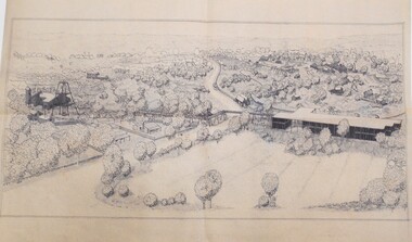
![View of the Township of Mt. Blackwood / [by] Nicholas Caire, circa 1876](/media/collectors/550653872162f11fb04854aa/items/57830cfbd0cdd1176c424e00/item-media/57830d7ad0cdd1176c428423/item-fit-380x285.jpg?cb=6) Kew Historical Society Inc
Kew Historical Society IncPhotograph, Anglo-Australasian Photographic Company, View of the Township of Mt. Blackwood, c. 1876
... This scene is characteristic of the wild appearance which many of the inland townships of Victoria represent.’...This scene is characteristic of the wild appearance which many of the inland townships of Victoria represent.’ ‘View of the Township of Mt. ...Nicholas Caire was born on Guernsey in the Channel Islands in 1837. He arrived in Adelaide with his parents in about 1860. In 1867, following photographic journeys in Gippsland, he opened a studio in Adelaide. From 1870 to 1876 he lived and worked in Talbot in Central Victoria. In 1876 he purchased T. F. Chuck's studios in the Royal Arcade Melbourne. In 1885, following the introduction of dry plate photography, he began a series of landscape series, which were commercially successful. As a photographer, he travelled extensively through Victoria, photographing places few of his contemporaries had previously seen. He died in 1918. Reference: Jack Cato, 'Caire, Nicholas John (1837–1918)', Australian Dictionary of Biography.An original, rare photograph from the series 'Views of Victoria: General Series' by the photographer, Nicholas Caire (1837-1918). The series of 60 photographs that comprise the series was issued c. 1876 and reinforced a neo-Romantic view of the Australian landscape to which a growing nationalist movement would respond. Nicholas Caire was active as a photographer in Australia from 1858 until his death in 1918. His vision of the Australian bush and pioneer life had a counterpart in the works of Henry Lawson and other nationalist poets, authors and painters.‘View of the Township of Mt. Blackwood’ : Views of Victoria (General Series) No.42 : Albumen silver photograph | Photo on card with Title and Description on reverse | Mounted 24 x 30 cm; Photo 12 x 17 cm.On Reverse: ‘The locality which this illustration represents was formerly known as the Blackwood Forest, and has been the scene of considerable mining activity. The shallow alluvial diggings of the early days have given place to the deep sinking in search of reefs. This scene is characteristic of the wild appearance which many of the inland townships of Victoria represent.’nicholas caire (1837-1918), blackwood (vic), mount blackwood, landscape photography - victoria -
 Bendigo Historical Society Inc.
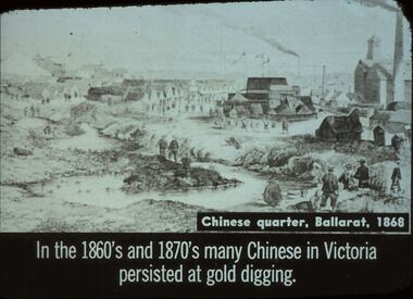
Slide - DIGGERS & MINING. THE CHINESE ON THE GOLD FIELDS, c1868
... Diggers & Mining. The Chinese on the Gold Fields. Slide: Chinese quarter, Ballarat, 1868. ...Used as a teaching aid. Slide DIGGERS & MINING. THE CHINESE ON THE GOLD FIELDS ...Diggers & Mining. The Chinese on the Gold Fields. Slide: Chinese quarter, Ballarat, 1868. In the 1860s and 1870s many Chinese in Victoria persisted at gold digging. Slide shows township and Chinese along the creek looking for gold. Markings: 13. Used as a teaching aid.hanimounteducation, tertiary, goldfields -
 Bendigo Historical Society Inc.
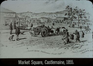
Slide - DIGGERS & MINING. GOLD, c1855
... Diggers & Mining. Gold. Market Square Castlemaine, Forest Creek. ...Used as a teaching aid. Slide DIGGERS & MINING. GOLD ...Diggers & Mining. Gold. Market Square Castlemaine, Forest Creek. James J Bundell & Co, Melbourne 1855. Shows the small township, people wagons, dogs. Market Square Castlemaine, 1855. Markings: 26 994.GOL. Used as a teaching aid.hanimounteducation, tertiary, goldfields -
 Bendigo Historical Society Inc.
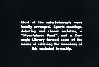
Slide - DIGGERS & MINING. DIGGERS AND MINERS, 1850s
... Diggers & Mining. Diggers and Miners. Most of the entertainments were locally arranged. ...Slide DIGGERS & MINING. DIGGERS AND MINERS ...Diggers & Mining. Diggers and Miners. Most of the entertainments were locally arranged. Sports meetings, debating and choral societies, a 'Mountaineer Band', and a Carneigie library formed some of the means of relieving the monotony of this secluded township. Markings: 50 994.5 WAL. Used as a teaching aid.hanimounteducation, tertiary, goldfields -
 Bendigo Historical Society Inc.
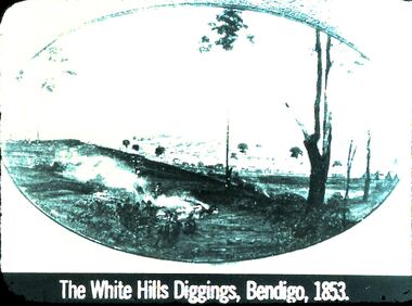
Slide - DIGGERS & MINING: THE DIGGINGS - THE DIGGERS
... Diggers & Mining: The Digging - The Diggers. Slide depicts: The White Hills Diggings, Bendigo, 1853. ...Slide DIGGERS & MINING: THE DIGGINGS - THE DIGGERS ...Diggers & Mining: The Digging - The Diggers. Slide depicts: The White Hills Diggings, Bendigo, 1853. Shows aborigines sitting on near side of hill. Over the hill in the back ground is a small township forming. Markings: 22 994.LIF:6. Used as a teaching aid.hanimounteducation, tertiary, goldfields -
 Bendigo Historical Society Inc.
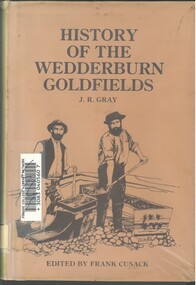
Book - HISTORY OF THE WEDDERBURN GOLDFIELDS, 1888
... It was soon found that the area was not suitable for alluvial mining because of a lack of water but quartz mining was more successful. ...It was soon found that the area was not suitable for alluvial mining because of a lack of water but quartz mining was more successful. ...Gold was first discovered in 1852 on what was then named Korong or Mt Korong goldfields. It was soon found that the area was not suitable for alluvial mining because of a lack of water but quartz mining was more successful. The township of Wedderburn was surveyed 1856/57. The first public crushing works was established in 1859.Hardcover book with printed dust jacket and plastic cover. 92 pages with black and white illustrations, fold out map and index. Covers the history of the Wedderburn Goldfields and the discovery of gold generally in Australia from the 1850s until c1880s. Written by Joshua R Gray and edited by Frank Cusack.Joshua R Gray and Frank Cusack.gold, goldfields, goldfield -
 Bendigo Historical Society Inc.
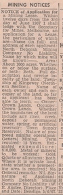
Newspaper - MINING REPORTS - NOTICE OF APPLICATION FOR A MINING LEASE
... Notice of Application for a Mining Lease from the Bendigo Advertiser 8/6/1967. ...History House 11 Mackenzie Street Bendigo goldfields NEWSPAPER Bendigo advertiser Mining Reports Notice of Application for a Mining Lease North Deborah Mining Company No Liability W E Anstee Notice of Application for a Mining Lease from the Bendigo Advertiser 8/6/1967. ...Notice of Application for a Mining Lease from the Bendigo Advertiser 8/6/1967. Proposed lease is for about 1000 acres in the Township of Kingower (Nrthern Section). Owner/occupier - Crown Land, so far as the applicant has been able to learn. Term required 15 years. Applicant was North Deborah Mining Company No Liability (W. E. Anstee, Director). Place and date: Bendigo, 5/6/67.newspaper, bendigo advertiser, mining reports, notice of application for a mining lease, north deborah mining company no liability, w e anstee -
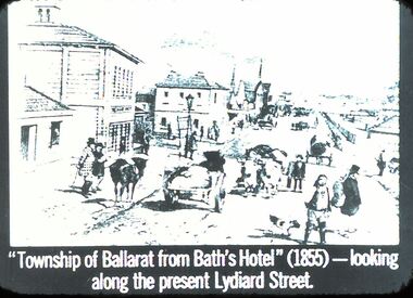 Bendigo Historical Society Inc.
Slide - DIGGERS & MINING: THE DIGGINGS - THE DIGGERS
... Diggers & Mining: The Digging - The Diggers. Slide: ''Township of Ballarat from Bath's Hotel'' (1855) - looking along the present Lydiard Street. ...History House 11 Mackenzie Street Bendigo goldfields EDUCATION Tertiary goldfields hanimount Diggers & Mining: The Digging - The Diggers. Slide: ''Township of Ballarat from Bath's Hotel'' (1855) - looking along the present Lydiard Street. ...Diggers & Mining: The Digging - The Diggers. Slide: ''Township of Ballarat from Bath's Hotel'' (1855) - looking along the present Lydiard Street. Shows the hustle and bustle of the towns that have grown from gold. Black and white side. Markings: 41 994.LIF:6. Used as a teaching aid.hanimounteducation, tertiary, goldfields