Showing 622 items matching "mining gullies"
-
 Bendigo Historical Society Inc.
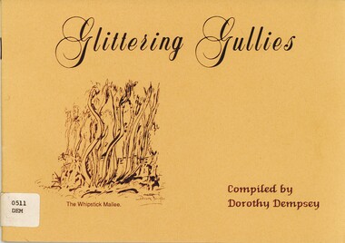
Book - GLITTERING GULLIES, 1988
... mining... gullies...'Glittering gullies' Collection of black line drawings of various aspects of mining in the 'gullies' of Bendigo. 32 pages...History House 11 Mackenzie Street Bendigo goldfields ART gold mining Bendigo gold mining gullies art Dorothy Dempsey 'Glittering gullies' Collection of black line drawings of various aspects of mining in the 'gullies' of Bendigo. 32 pages Book GLITTERING GULLIES ...'Glittering gullies' Collection of black line drawings of various aspects of mining in the 'gullies' of Bendigo. 32 pagesDorothy Dempseyart, gold mining, bendigo, gold, mining, gullies, art -
 Bendigo Historical Society Inc.
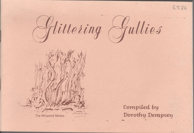
Booklet - Glittering Gullies
... Mining gullies...Titled 'Glittering Gullies' a compilation of 15 B&W sketches by Dorothy Dempsey of mining scenes and buildings. ...He lived at "The Roselands", View Street, where he also conducted private art lessons after his retirement. Mining gullies Bendigo Beige soft cover booklet of 32 pages. ...1. Dorothy Dempsey was a student of Arthur Thomas Woodward (see No.2). She was considered a "promising artist" who exhibited in Bendigo and Melbourne in the late 1930's - early 1940's. The Bendigo Art Gallery has one of her paintings. 2. Arthur Thomas Woodward (1865, Birmingham, England- 12/2/1943 Bendigo) Studied and taught art in England, Paris and Antwerp before coming to Victoria in 1889. Whilst briefly the Art Director of the Sale School of Art, he married Emma Jane Stokes in 1892. He then became the Head of the Art Department at the Bendigo School of Mines, where he remained until his retirement in 1921. He was responsible for the art division of the Victorian Gold Jubilee Exhibition. and was heavily involved in the establishment of the Bendigo Art Gallery. He lived at "The Roselands", View Street, where he also conducted private art lessons after his retirement.Beige soft cover booklet of 32 pages. Titled 'Glittering Gullies' a compilation of 15 B&W sketches by Dorothy Dempsey of mining scenes and buildings. Inside is a loose card of a handwritten invitation to the announcement of the publication of 'Glittering Gullies.' Dorothy Dempsey was a student of Arthur T Woodward, Bendigo. mining gullies, bendigo -
 Bendigo Historical Society Inc.
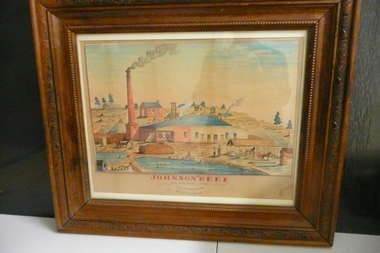
Painting - JOHNSON'S REEF GOLD MINING COMP
... Water colour painting of Johnson's Reef Gold Mining Camp California Gully Bendigo Victoria Australlia....History House 11 Mackenzie Street Bendigo goldfields ORGANIZATION Mining johnsons reef Water colour painting of Johnson's Reef Gold Mining Camp California Gully Bendigo Victoria Australlia. ...Water colour painting of Johnson's Reef Gold Mining Camp California Gully Bendigo Victoria Australlia.organization, mining, johnsons reef -
 Bendigo Historical Society Inc.
Administrative record - Spring Gully Gold Mining Co. Fryerstown, Minute Book1903 - 1915, 1924 - 1929
... Spring Gully Gold Mining Co. Fryerstown, Minute Book1903 - 1915...The Spring Gully Gold Mining property consists of Gold Mining Lease No. 2986, Castlemaine, of about 21 acres situated on the Emu Reef, in Spring Gully Fryers. ...Prospectus of the Spring Gully Mining Company, Spring Gull, Fryerstown, two page folded document enclosed inside back cover of book. ...Prospectus of the Spring Gully Mining Company, Spring Gull, Fryerstown, two page folded document enclosed inside back cover of book. ...The Spring Gully Gold Mining property consists of Gold Mining Lease No. 2986, Castlemaine, of about 21 acres situated on the Emu Reef, in Spring Gully Fryers. There are two shafts, distant about 300 feet from each other. From one of them large quantities of gold were obtained in former years by previous companies. ( Prospectus of the Spring Gully Mining CompanyMaroon hard cover book, brown leather binding on spine and corners, three hundred and eighty pages. Written on spine of book in gold leaf : 'Minute Book'. Handwritten minute entries from 14th September 1903 to 30th August 1915. Affixed to first page, newspaper clipping from the 'Herald' 13/9/05, with information about the Spring Gully Mine Fryerstown. Page eighty-one has two quotes affixed from 'The Yarraville Chlorination and Ore Reduction Works' High Street Yarraville, July 1905, for works associated with pyrites and blanket sand. Page nine, a handwritten letter affixed to minutes, applying for a block of land 250 feet north of main shaft. Signed by J.S. Potter, H. Hancock, G Murray and T. Tumney. 1.Page one hundred and one: three quotes from 'Edwards' Metallurgical Works' Specimen Hill, Bendigo for pyrites and blanket sand. 2.Page one hundred and fifty five: handwritten letter (copy) from A. Schonfelder re shaft work on the mine and mention of tributors 3. Affixed to inside cover: letter from the 'United Shire of Mount Alexander' April 15th. 1907, regarding the reconstruction of the Vaughan bridge over the Loddon River. 'the benefit that the mines in your district derive from the bridge being open for wood waggons and this being the main traffic and this being the principal cause of the bridges present condition'. 4. Prospectus of the Spring Gully Mining Company, Spring Gull, Fryerstown, two page folded document enclosed inside back cover of book. Prospectus incomplete. (10746.93a) 5. Carbon copy of letter to D.E. Williams Esq, Castlemaine from GlenAthol, Casewick Road, London, January 25th, 1907 regarding two gentlemen who were 'called upon to carry the 'Spring Gullys' through - Mr. H. 'is making a determined effort to bring the matter to a successful issue' Letter signed by George Allan. (10746.93b. 6. Carbon copy of letter from E. Williams, London re proposed new company to acquire the properties of Spring G.M. Coy, Spring Gully G.M. Coy. No. 1, Sth Spring Gully G.M. Coy, Sth Spring Gully G.M. Coy Extended (10746.93c) 7. Handwritten letter to the Chairman and Directors of the Spring Gully G.M. Co. re the appointment of 'Mr. Samuel Morse Battery Manager at once, or accept my resignation as Mining Manager, for we can't agree any longer' Signed by A. Schonfelder. 8. Notice of extraordinary meeting of shareholders in Spring Gully Gold Mining Company No Liability, 22nd November 1906 at Beehive Chambers, Bendigo. Signed W.G. Blackham (Blackham & Garvin) Manager of the Company. (10746.93e) The Minute Book is part of the Margaret Roberts Collection of mining documents.bendigo, margaret roberts, , goldmining, castlemaine, spring gully gold mine, fryertown -
 Bendigo Historical Society Inc.
Plan - New Chum and Victoria Lease
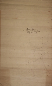
... New Chum Gully is one of the earliest and most important alluvial and quartz mining gully of Bendigo goldfields. It was also one of the more lucrative reefs and became the site of extensive quartz reef mining with some of the richest mines of the field, led by George Lansell and Daniel Barnet Lazarus. ...New Chum Gully is one of the earliest and most important alluvial and quartz mining gully of Bendigo goldfields. It was also one of the more lucrative reefs and became the site of extensive quartz reef mining with some of the richest mines of the field, led by George Lansell and Daniel Barnet Lazarus. ...New Chum Gully is one of the earliest and most important alluvial and quartz mining gully of Bendigo goldfields. It was also one of the more lucrative reefs and became the site of extensive quartz reef mining with some of the richest mines of the field, led by George Lansell and Daniel Barnet Lazarus. These included the nearby mine sites of New Chum and Victoria, New Chum United, Old Chum, Lansells 222 and Lazarus as well as operating extensive battery buildings and pyrites works that were all located in New Chum Gully between Booth, Thistle Streets and Maple Street. (City of Greater Bendigo, Heritage Report, 27 Pallett Street, Golden Square)New Chum and Victoria Lease plan. Written on outside of plan: ' Western Portion, New Chum and Victoria Lease, 2 chains to an inch'. Plan forms part of the Margaret Roberts Collection of mining records. margaret roberts, gold, gold mine, new chum and victoria lease, victoria hill, bendigo -
 Bendigo Historical Society Inc.
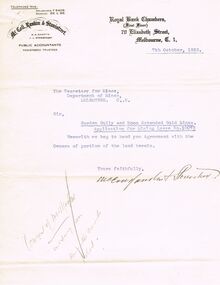
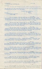
Document - MCCOLL, RANKIN AND STANISTREET COLLECTION: APPLICATION FOR MINING LEASE, 87th Octoner, 1933
... Mining...Lease Application...Garden Gully...Application for mining lease; Garden Gully and Moon Extended Gold mines, Lease No. 10073 and a receipt for same (3 documents in total). ...History House 11 Mackenzie Street Bendigo goldfields GOLD Mining Lease Application Garden Gully and Moon Exlended Gold Mines Bendigo Gold Mining McColl Rankin & Stanistreet Application for mining lease; Garden Gully and Moon Extended Gold mines, Lease No. 10073 and a receipt for same (3 documents in total). ...Application for mining lease; Garden Gully and Moon Extended Gold mines, Lease No. 10073 and a receipt for same (3 documents in total). Dated 7th October 1933.McColl Rankin & Stanistreetgold, mining, lease application, garden gully and moon exlended gold mines, bendigo, gold mining -
 Bendigo Historical Society Inc.
Document - OPOSSUM GULLLY ALLUVIAL WORKING, DIAMOND HILL
... Mining...opossum gully...One page document detailing location and description of physical mining remains in Opossum Gully, Diamond Hill Historic area....History House 11 Mackenzie Street Bendigo goldfields BENDIGO Mining opossum gully One page document detailing location and description of physical mining remains in Opossum Gully, Diamond Hill Historic area. ...One page document detailing location and description of physical mining remains in Opossum Gully, Diamond Hill Historic area.bendigo, mining, opossum gully -
 Linton and District Historical Society Inc
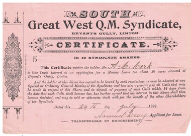
Share certificate, Berry Anderson & Co, Ballarat, South Great West Q.M. Syndicate, 1899, 1899
... Cork and entitled him to a one-tenth interest in an application for a mining lease at Bryant's Gully, Linton....Cork and entitled him to a one-tenth interest in an application for a mining lease at Bryant's Gully, Linton. South Great West Q.M. ...The certificate was issued to A. C. Cork and entitled him to a one-tenth interest in an application for a mining lease at Bryant's Gully, Linton.Pink paper, black printing, headed South Great West Q.M. Syndicate, dated 24th July 1899, signed Samuel Devy. Decorative design printed in left hand margin. Number "5" on certificate. Serrated left edge of certificate suggests it was detached from a booklet or form.Text: " SOUTH / Great West Q.M. Syndicate, BRYANT'S GULLY, LINTON. "south great west q.m. syndicate, gold mining, mining leases, mining share certificates, a.c. cork -
 Federation University Art Collection
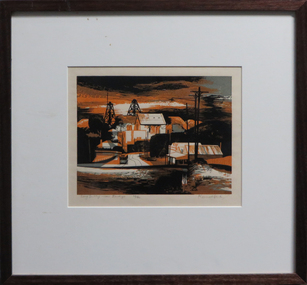
Work on paper - Artwork - Printmaking, Jack, Kenneth, 'Long Gully near Bendigo' Kenneth Jack, 1960
... Framed Limited Edition print showing a mining township at Long Gully, Bendigo. Donated through the Australian Gifts Programme by Katherine Littlewood....Federation University Art Collection Artworks are displayed at Federation University Australia campuses at Ballarat, Gippsland (Churchill), Stawell and Horsham. goldfields goldfields poppet head bendigo long gully tram 29/40 Framed Limited Edition print showing a mining township at Long Gully, Bendigo. ...Framed Limited Edition print showing a mining township at Long Gully, Bendigo. Donated through the Australian Gifts Programme by Katherine Littlewood.29/40goldfields, poppet head, bendigo, long gully, tram -
 Bendigo Historical Society Inc.
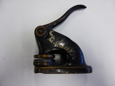
Tool - COMPANY SEAL - CENTRAL GARDEN GULLY GOLD MINING COMPANY
... COMPANY SEAL - CENTRAL GARDEN GULLY GOLD MINING COMPANY...Mining equipment...Company seal...Bendigo-companies-gold mines-central garden gully gold mining company...Black enamelled cast iron company seal for the Central Garden Gully Gold Mining Company, with gold trim and C.G.Gully painted on one side in white paint....Tool COMPANY SEAL - CENTRAL GARDEN GULLY GOLD MINING COMPANY ...Black enamelled cast iron company seal for the Central Garden Gully Gold Mining Company, with gold trim and C.G.Gully painted on one side in white paint.gold mines, mining equipment, company seal, bendigo-companies-gold mines-central garden gully gold mining company -
 Linton and District Historical Society Inc
Mining company registration form, Washington Gold Mining Company
... Mining Company... James Bell... David Barisford... Charles Fox... Richard Hedley... George Bamboro... Nicholas Dunstan... Jas Shipley Lilly... J. T. Webb... Sailor's Gully...The page lists information about the Washington Gold Mining Company at Sailor's Gully, Linton - company registration number (175), date of registration (6th February 1862), class of mining, location, names of shareholders and their mining right numbers....Linton and District Historical Society Inc 69 Sussex Street Linton 3360 goldfields The page lists information about the Washington Gold Mining Company at Sailor's Gully, Linton - company registration number (175), date of registration (6th February 1862), class of mining, location, names of shareholders and their mining right numbers. ...The page lists information about the Washington Gold Mining Company at Sailor's Gully, Linton - company registration number (175), date of registration (6th February 1862), class of mining, location, names of shareholders and their mining right numbers.A3 size photocopy of a page which has probably come from a register of mining companies, most likely maintained at the Smythesdale Court of Mines or another local Court of Mines. (The actual source of the document is not known.) The page is numbered "25" at the top left.gold mining, mining companies, court of mines, registration forms, shareholders, washington gold mining company, james bell, david barisford, charles fox, richard hedley, george bamboro, nicholas dunstan, jas shipley lilly, j. t. webb, sailor's gully (linton), documents and records, mining company registers -
 Bendigo Historical Society Inc.
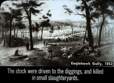
Slide - DIGGERS & MINING. STORES AT THE DIGGINGS, c1852
... Slide shows mining area at Eaglehawk Gully. Markings: 24 994.LIF. 5. ...Slide shows mining area at Eaglehawk Gully. Markings: 24 994.LIF. 5. ...Diggers & Mining. Stores at the diggings. Eaglehawk Gully, 1852. The Stock were driven to the diggings, and killed in small slaughter yards. Slide shows mining area at Eaglehawk Gully. Markings: 24 994.LIF. 5. Used as a teaching aid.hanimounteducation, tertiary, goldfields -
Bendigo Historical Society Inc.
Archive - MCCOLL, RANKIN AND STANISTREET COLLECTION: SOUTH WATTLE GULLY COMPANY N/L - MINING BOX, 1930's
... MCCOLL, RANKIN AND STANISTREET COLLECTION: SOUTH WATTLE GULLY COMPANY N/L - MINING BOX...mining box 15...McColl... Rankin & Stanistreet... South Wattle Gully...Formerly box number 479 - now South Wattle Gully Mining Box 15. Tag affixed to front 'box 479'. ...History House 11 Mackenzie Street Bendigo goldfields MINING Business mining box 15 McColl Rankin & Stanistreet South Wattle Gully Company N/L gold mining mining box South Wattle Gully Mining Box. ...Mining Box. Metal box painted dark blue with South Wattle Gully painted in white on the front. Formerly box number 479 - now South Wattle Gully Mining Box 15. Tag affixed to front 'box 479'. Box contains various documents relating to South Wattle Gully Mine. Documents are individually catalogued within the box.South Wattle Gullymining, business, mining box 15, mccoll, rankin & stanistreet, south wattle gully company n/l, gold mining, mining box -
Linton and District Historical Society Inc
Mining company registration form, Pickard and Party Mining Company
... Mining companies... Court of Mines... Registration forms... Shareholders... Pickard and Party... Daniel Pickard... Peter Fallwood... Zachariah Foster... Murphy's Gully...The page lists information about Pickard and Party, a gold mining collaboration at Murphy's Gully near Happy Valley - company registration number (156), date of registration (9th December 1861), location of claim, names of shareholders in the "Party" and their mining right numbers, and transfers of share ownership which have taken place....Linton and District Historical Society Inc 69 Sussex Street Linton 3360 goldfields The page lists information about Pickard and Party, a gold mining collaboration at Murphy's Gully near Happy Valley - company registration number (156), date of registration (9th December 1861), location of claim, names of shareholders in the "Party" and their mining right numbers, and transfers of share ownership which have taken place. ...The page lists information about Pickard and Party, a gold mining collaboration at Murphy's Gully near Happy Valley - company registration number (156), date of registration (9th December 1861), location of claim, names of shareholders in the "Party" and their mining right numbers, and transfers of share ownership which have taken place.A3 size photocopy of a page which has probably come from a register of mining companies, most likely maintained at the Smythesdale Court of Mines or another local Court of Mines. (The actual source of the document is not known.) The page is numbered "3" at the top left.gold mining, mining companies, court of mines, registration forms, shareholders, pickard and party, daniel pickard, peter fallwood, zachariah foster, murphy's gully (happy valley), documents and records, mining company registers -
 Bendigo Historical Society Inc.
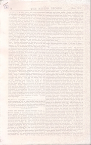
Document - MINING REPORTS - MINING RECORD FEB., 1862
... Mining Co... Mr Bland... R Brough Smith... John S McNair... John Mathieson... Mr R O Smith... Joseph Millen... Thomas Kaye... John Basset... William Cook... James Cousley... John Hill... Robert Hollinger... Thomas Houston... George Loudon... William Manning... John Matthews... John McEwen... Thomas Milligan... John Moorhead... Robert Moorhead... David Murdoch... Andrew Murdoch... Joseph Nevin... Edward O'Malley... Wm Newton Paul... James Reid... Samuel Robinson... Jesse Selwood... James Shand... William Woods... Catherine United Claimholders... Star Reef Co... Sailor's Gully...s Claim, Sailor's gully quartz Mining Company's Claim, Garden Gully Reef, Knobel & Co.'...s Claim, Sailor's gully quartz Mining Company's Claim, Garden Gully Reef, Knobel & Co.' ...Photocopy of pages 2, 3, 4, 6 to 10 of The Mining Record, Feb. 1862. Items mentioned are:- Epsom and Huntly Leads, Pottery Flat, & c, Parliamentary Intelligence, Deep Sinking On Quartz Reefs, The Comet Company (Formerly Cooper's Little Redan), Hustler's Reef Quartz Mining & Drainage Company, Sailors' Gully Quartz Mining Company, Star Reef, Sailor's Gully, Bendigo, Star Reef Quartz Mining Company's Claim, Wilson & Co's Claim, Murdoch and Co's Claim, Hollick and Co.'s Claim, Cook and Co.'s Claim, Coote and Co.'s Claim, Sailor's gully quartz Mining Company's Claim, Garden Gully Reef, Knobel & Co.'s Claim, Ladams and Co.'s Claim, Southern Cross Company, The Rainbow Company, Barry and Co.'s Claim, Union Company's Claim, Winterbottom and Co.s Claim, Jury and Co.'s Claim, Piles and Co.'s Claim, Steers and Co.'s Claim, Watson and Co.'s Claim, Coles and Co.'s Claim, James and Co.'s Claim, Morgan, Kirchner and Co.'s Claim, Boyd and Co.'s Claim, Shanks and Co.'s Claim, Day and Co.'s Claim, Brown and Co.'s Claim, St. Mungo Quartz Mining Company and the Nelson Reef Quartz Mining Company.document, gold, mining reports, mining record feb 1862, bell's life, wellington hotel, botanical gardens, mitchell gardens, bird-in-hand, independent co, ballarat co, perserverance co, north star co, all england co, macleod co, mather and co, gold washing co, bendigo valley co, robey and co, hobbs and co, taylor's, lewis and co, henwood and co, bullock and co, davey and co, webb and lathlean, the welshman's, bon accord, john thomas's, caledonian co, webster, hrdy bros, mcewen and co, the big engine co, epsom huntly and ironstone hill co, 'the thames' steamer, whitely and co, cambridge co, victoria co, dower m'intosh and co, thomas and davies, aurora co, brett's, thomas bros, mitchell brothers, ballarat co, north star co, all england co, mr b g davies, mr ramsay, dr evans, tarrangower times, mr humffray, clunes co, mr courtin, mr lawrence, port phillip and colonial gold mining co, mr bland, r brough smith, john s mcnair, john mathieson, mr r o smith, joseph millen, thomas kaye, john basset, william cook, james cousley, john hill, robert hollinger, thomas houston, george loudon, william manning, john matthews, john mcewen, thomas milligan, john moorhead, robert moorhead, david murdoch, andrew murdoch, joseph nevin, edward o'malley, wm newton paul, james reid, samuel robinson, jesse selwood, james shand, william woods, catherine united claimholders, star reef co, sailor's gully co, churchill davidson, wm wilson, john jervis, james patterson, john carmont, george m'naughten, alexander wiseman, james houston, m'lennan, clark, thomas hollick, james alfred bowles, john lampert, francis palmetser, nichols, little pumping engine co, m'niely, morrison, waight, john coote, robert hamilton, william wilson, john jervis, southern cross co, ladam's claim, knobel, bird, philip ladams, james anderson, cordon, ashley, godwin, burkamp, john lomasney, james bryant, matthew langridge, benjamin exley, j r finlayson, wormold, mccartney, schrade, schumacher, george barry, james patten, peter speares, thomas caley, shadbolt, john lomasney, peat, kenely, mcgenely, egan, exwell, james winterbottom, john winterbottom, william jury, jonathan laidman, john pile, simon howard, peter morris, bignall, charles robison, ferguson, thomas steers, adolphe witts, albert berchdolt, richard urand, thomas watson, klemm, boyd, abbot, peterson, taylor, henry day, walter wallan, brown, grennan, day, young, mr beckwith, joseph thomson, nelson reef quartz mining co -
 Linton and District Historical Society Inc
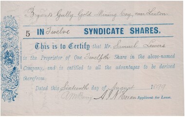
Share certificate, Berry Anderson & Co., Ballarat, Bryant's Gully Gold Mining Company, near Linton, 1899, 1899
... Bryant's Gully Gold Mining Company, near Linton, 1899...... Bryant's Gully Gold Mining Company...Share certificate for twelve syndicate shares (= 1/12th share in Bryants Gully Gold Mining Company ) purchased by Samuel Lewers, 16th August 1899. ...Text, front: " Bryant's Gully Gold Mining Coy., near Linton / 5 IN Twelve SYNDICATE SHARES. ...Horan Bryant's Gully Gold Mining Company Share certificates Text, front: " Bryant's Gully Gold Mining Coy., near Linton / 5 IN Twelve SYNDICATE SHARES. ...Share certificate for twelve syndicate shares (= 1/12th share in Bryants Gully Gold Mining Company ) purchased by Samuel Lewers, 16th August 1899. Signed A.M. Barry and A.J. N. Horan, who were the "Applicants for Lease". According to an undated inscription on the back of the certificate, half of the shares were later transferred by Samuel Lewers to A.C. Cork.Blue paper share certificate, blue typescript, black ink handwriting, perforations on left side suggests certificate was detached from a book of share certificate forms.Text, front: " Bryant's Gully Gold Mining Coy., near Linton / 5 IN Twelve SYNDICATE SHARES. Text, reverse: "I hereby transfer one half (1/2) of the within share to A.C. Cork for value received S. Lewers".samuel lewers, a.c.cork, a.m. barry, a. j. n. horan, bryant's gully gold mining company, share certificates -
Linton and District Historical Society Inc
Mining company registration form, Break O'Day Company and Perkins and Pary
... The page lists information about the Break'O'Day Company, a mining company at Nuggetty Gully, Linton, and also for an adjoining claim operated by Perkins and Party. ...Linton and District Historical Society Inc 69 Sussex Street Linton 3360 goldfields The page lists information about the Break'O'Day Company, a mining company at Nuggetty Gully, Linton, and also for an adjoining claim operated by Perkins and Party. ...The page lists information about the Break'O'Day Company, a mining company at Nuggetty Gully, Linton, and also for an adjoining claim operated by Perkins and Party. The page records the company registration numbers (188 and 188/2), date of registration (19th March 1862, for both), class of mining, location, names of shareholders and their mining right numbers, and transfers of share ownership which have taken place.A3 size photocopy of a page which has probably come from a register of mining companies, most likely maintained at the Smythesdale Court of Mines or another local Court of Mines. (The actual source of the document is not known.) The page is numbered "38" at the top left.gold mining, mining companies, court of mines, registration forms, shareholders, break'o'day company, perkins and party, christopher barnett, peter husband, benjamin campbell, george perkins, john jamieson, james foster, documents and records, mining company registers -
 Bendigo Historical Society Inc.
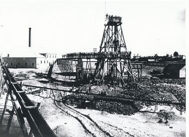
Photograph - GARDEN GULLY CLAIM
... On back in black ink: Mining Gold, Bendigo Garden Gully claim. Stamped on adhesive label in purple ink ' not to be reproduced without permission from the National Library of Australia '...On back in black ink: Mining Gold, Bendigo Garden Gully claim. Stamped on adhesive label in purple ink ' not to be reproduced without permission from the National Library of Australia ' Photograph GARDEN GULLY CLAIM ...Black and white photograph of mining scene showing staff standing on railway etc. of poppet head in middle ground. Buildings and elevated race at left. On back in black ink: Mining Gold, Bendigo Garden Gully claim. Stamped on adhesive label in purple ink ' not to be reproduced without permission from the National Library of Australia 'organization, business, garden gully claim -
 Bendigo Historical Society Inc.
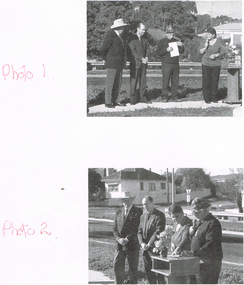
Photograph - LONG GULLY HISTORY GROUP COLLECTION: UNVEILING MINING MONUMENT
... LONG GULLY HISTORY GROUP COLLECTION: UNVEILING MINING MONUMENT...The Long Gully History Group - Unveiling Mining Monument...The names of the people are, from left, John Bolitho, Cr Darrel McClure, George Ellis and Carol Rasmussen at the unveiling of the Long Gully Mining Monument. (Names from same photo in Newsletter June 2003 - 11010.214). ...The names of the people are, from left, John Bolitho, Cr Darrel McClure, George Ellis and Carol Rasmussen at the unveiling of the Long Gully Mining Monument. (Names from same photo in Newsletter June 2003 - 11010.214). ...Page with three black and white photos, Two of them have four men and a lady and the third one is the same people standing behind and to the side of a little bench. The names of the people are, from left, John Bolitho, Cr Darrel McClure, George Ellis and Carol Rasmussen at the unveiling of the Long Gully Mining Monument. (Names from same photo in Newsletter June 2003 - 11010.214). Fixed to the paper is a nashuatec MF2HD disc with Miners Monument Long Gully 1 & 2.bendigo, history, long gully history group, the long gully history group - unveiling mining monument, nashuatec mf2hd disc, miners monument long gully -
 Bendigo Historical Society Inc.
Document - CENTRAL GARDEN GULLY GOLD MINING COMPANY - SHARE CERTIFICATE
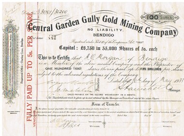
... CENTRAL GARDEN GULLY GOLD MINING COMPANY - SHARE CERTIFICATE...central garden gully gold mining co...Central Garden Gully Gold Mining Company Share Certificate No. of Issue 442 issued to A. ...History House 11 Mackenzie Street Bendigo goldfields MINE Gold central garden gully gold mining co Central Garden Gully Gold Mining Company A. ...Central Garden Gully Gold Mining Company Share Certificate No. of Issue 442 issued to A. O. Morgan of Bendigo for 100 shares. Dated 16th May 1933. J. J. Stanistreet (McColl, Rankin & Stanistreet), Manager, Bendigo. Registered office: Charing Cross, Bendigo. Printed by Boltons Print, Bendigo. J. Michelsen & Angus Mackay, Directors.mine, gold, central garden gully gold mining co, central garden gully gold mining company, a. o. morgan, j. j. stanistreet, mccoll, rankin & stanistreet, angus mackay, boltons print, michelsen -
 Bendigo Historical Society Inc.
Document - LONG GULLY HISTORY GROUP COLLECTION: LETTERS FROM THE LONG GULLY HISTORY GROUP
... Letter dated 7th May 2002 to Councillor Willi Carney from George Ellis, Long Gully History Group requesting the council to consider the site in their original application for the marker to acknowledge the achievement of underground mining Linear Park Long Gully. ...History House 11 Mackenzie Street Bendigo goldfields BENDIGO History long gully history group The Long Gully History Group - Letters from The Long Gully History Group Councillor Willi Carney City of Greater Bendigo George Ellis Letter dated 7th May 2002 to Councillor Willi Carney from George Ellis, Long Gully History Group requesting the council to consider the site in their original application for the marker to acknowledge the achievement of underground mining Linear Park Long Gully. ...Letter dated 7th May 2002 to Councillor Willi Carney from George Ellis, Long Gully History Group requesting the council to consider the site in their original application for the marker to acknowledge the achievement of underground mining Linear Park Long Gully. The allocated site is unsuitable as the ground is unstable and work to stabilise the ground to stop it from tipping could double the cost.bendigo, history, long gully history group, the long gully history group - letters from the long gully history group, councillor willi carney, city of greater bendigo, george ellis -
 Bendigo Historical Society Inc.
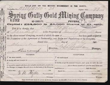
Document - KELLY AND ALLSOP COLLECTION: SHARE CERTIFICATES - SPRING GULLY GOLD MINING CO, 29/07/1901
... KELLY AND ALLSOP COLLECTION: SHARE CERTIFICATES - SPRING GULLY GOLD MINING CO...... Spring Gully Gold Mining Co....Two share certificates issued by the Spring Gully Gold Mining Company, No Liability, Fryers. ...Spring Gully Gold Mining Co....History House 11 Mackenzie Street Bendigo goldfields BUSINESS Stockbroker kelly & allsop KELLY & ALLSOP COLLECTION Share Certificates Spring Gully Gold Mining Co. E.M.Hogan W.G.Blackham Spring Gully Gold Mining Co. ...Document. KELLY & ALLSOP COLLECTION. Two share certificates issued by the Spring Gully Gold Mining Company, No Liability, Fryers. Each certificate represents 25 shares @ 1 Pound each. Capital raised was 24,000 pounds from 24,000 shares. Certificate Nos. 1182 & 1183 issued to E.M.Hogan of Bendigo on 29 July 1901 and signed by W.G.Blackham, Manager. Printed by Bolton Bros., Bendigo.Spring Gully Gold Mining Co.business, stockbroker, kelly & allsop, kelly & allsop collection, share certificates, spring gully gold mining co., e.m.hogan, w.g.blackham -
 Linton and District Historical Society Inc
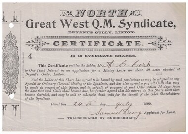
Certificate - Mining Lease, North Great West Q.M. Syndicate, Bryant's Gully, Linton, 1899, 1899
... Mining...Leases...North Great West Q.M. Syndicate...Bryant's Gully...Cork and entitled him to a one-tenth interest in an application for a mining lease at Bryant's Gully, Linton....Cork and entitled him to a one-tenth interest in an application for a mining lease at Bryant's Gully, Linton. North Great West Q.M. ...Grey paper, black printing, headed North Great West Q.M. Syndicate, dated 24th July 1899, signed Samuel Devy. Decorative design printed in left hand margin. Number "4" on certificate. Serrated left edge of certificate suggests it was detached from a booklet or form. The certificate was issued to A. C. Cork and entitled him to a one-tenth interest in an application for a mining lease at Bryant's Gully, Linton.mining, leases, north great west q.m. syndicate, bryant's gully, linton, a.c. cork -
 Bendigo Historical Society Inc.
Administrative record - Central Garden Gully Gold Mine Gold Book, 1934 - 1917
... On front cover on white label ' Central Garden Gully Gold Mining Co., Gold Book' . Gold book contains entries from August 1920 to December 1937. ...Mining Co. N.L. Sebastian McColl Rankin and Stanistreet assayed melted gold Bank of Victoria Bendigo Patterned blue hard cover, black binding on spine. On front cover on white label ' Central Garden Gully ...Patterned blue hard cover, black binding on spine. On front cover on white label ' Central Garden Gully Gold Mining Co., Gold Book' . Gold book contains entries from August 1920 to December 1937. Affixed to inside of back cover, two statements from the Bank of Victoria Limited for New Chum Goldfields Co., for gold melted and assayed for New Chum Goldfield Co., September 1920. Gold Book forms part of the Margaret Roberts Minine Collection.bendigo, margaret roberts, south frederick the great gold mining co. n.l., sebastian, mccoll, rankin and stanistreet, assayed, melted, gold, bank of victoria bendigo -
 Bendigo Historical Society Inc.
Document - ALBERT RICHARDSON COLLECTION: MINING CONTRACTS
... Mining Records, Contracts 23.11.1861, page 15. Mine listed are Johnson Reef Gold Mines Co. To put down a winze to 305 feet level. Contract for carting away tailings, contract for putting in x cut and materials. Gibbs and Lazarus Claim, contract to sink the cut East Reef; Londonderry Co's Claim contract to erect horse and poppet heads; Sailors Gully Quartz Mining Co., erection of engine and boiler, brick foundation 15 ft high, fixing bob of pump....Mining Records, Contracts 23.11.1861, page 15. Mine listed are Johnson Reef Gold Mines Co. To put down a winze to 305 feet level. Contract for carting away tailings, contract for putting in x cut and materials. Gibbs and Lazarus Claim, contract to sink the cut East Reef; Londonderry Co's Claim contract to erect horse and poppet heads; Sailors Gully Quartz Mining Co., erection of engine and boiler, brick foundation 15 ft high, fixing bob of pump. ...One page document with information from Dickers Mining Records, Contracts 23.11.1861, page 15. Mine listed are Johnson Reef Gold Mines Co. To put down a winze to 305 feet level. Contract for carting away tailings, contract for putting in x cut and materials. Gibbs and Lazarus Claim, contract to sink the cut East Reef; Londonderry Co's Claim contract to erect horse and poppet heads; Sailors Gully Quartz Mining Co., erection of engine and boiler, brick foundation 15 ft high, fixing bob of pump.bendigo, mining, mining contracts -
 Bendigo Historical Society Inc.
Document - MINING WARDEN COLLECTION: BENDIGO HISTORICAL MINING RECORDS
... Ben # range from 2275 to 2584 Example of entry: Sydney Garden Gully Quartz Mining Co., Ben # 2371, Millers Reef, 1872 - 1875.... Ben # range from 2275 to 2584 Example of entry: Sydney Garden Gully Quartz Mining Co., Ben # 2371, Millers Reef, 1872 - 1875. ...Historical records originally from the Mining Warden's Office, Mines Department, Bendigo. A summary document lists the mine name; the Ben #; the line of reef located on, the start and end year. Information collated from 1870's to 1980's. Each mine's data is enclosed in a manilla folder within the box. Mines along the following reef lines are described: Hustlers Millers Derby Paddy's Gully Ben # range from 2275 to 2584 Example of entry: Sydney Garden Gully Quartz Mining Co., Ben # 2371, Millers Reef, 1872 - 1875.bendigo, mining, mining warden's records, mines, reef lines -
 Bendigo Historical Society Inc.
Document - MCCOLL, RANKIN AND STANISTREET COLLECTION: CENTRAL GARDEN GULLY GOLD MINING CO NL, AGREEMENTS, c1933
... MCCOLL, RANKIN AND STANISTREET COLLECTION: CENTRAL GARDEN GULLY GOLD MINING CO NL, AGREEMENTS... Central Garden Gully Gold Mining Co NL...McColl Rankin & Stanistreet, Central Garden Gully Gold Mining Co NL, agreements. All agreements were signed on 16.5.1933. a/ Claims numbered 31850 & 32794. ...History House 11 Mackenzie Street Bendigo goldfields ORGANIZATION Business central garden gully gm co nl McColl Rankin & Stanistreet Central Garden Gully Gold Mining Co NL agreements Indenture Joseph Samuel Trevan Alexander Ceresa Charles Henry Brown John J Stanistreet Joseph Samuel Revan Charles Henry Brown A O Morgan mining lease No. 9993 McColl Rankin & Stanistreet, Central Garden Gully Gold Mining Co NL, agreements. ...McColl Rankin & Stanistreet, Central Garden Gully Gold Mining Co NL, agreements. All agreements were signed on 16.5.1933. a/ Claims numbered 31850 & 32794. Signed Joseph Samuel Trevan, Alexander Ceresa, Charles Henry Brown, John Jepson Stanistreet in the presence of ?? Leed. Attached to Agreement is and Indenture dated 16.5.1933 between John Jepson Stanistreet, Joseph Samuel Revan, Alexander Ceresa & Charles Henry Brown and Central Garden Gully Gold Mining Co NL discharging John Jepson Stanistreet from all liability in respect of said agreement. Dated 15.3.1933 Signed: J J Stanistreet, E R Grelis, Joseph S Trevan, A Ceresa, C H Brown, ?? Leed, Angus Mackay, // //, ? Stanistreet. b/ Date: 29.3.1933 , application for mining lease No. 9993 Agreement between Albert Oliver Morgan & John Jepson Stanistreet. Signed A O Morgan, J Stanistreet, ?? Leed & G R Grelis. Attached An Indenture dated 16.5.1933 signing over all benefits advantages and burdens thereof and all remedies. Signed J Stanistreet, A O Morgan, E R Grelis, ? Leed, Angus Mackay, J Michelson & Stanistreet. 4 pages. c/ Agreement dated 29.3.1933 is a copy of (b/)organization, business, central garden gully gm co nl, mccoll rankin & stanistreet, central garden gully gold mining co nl, agreements indenture joseph samuel trevan, alexander ceresa, charles henry brown, john j stanistreet, joseph samuel revan, charles henry brown, a o morgan, mining lease no. 9993 -
 Bendigo Historical Society Inc.
Document - LONG GULLY HISTORY GROUP COLLECTION: CORNISH ASSOCIATION NEWSLETTER JUNE 2003 - PRESIDENTS REPORT
... ... Long Gully Mining Monument...Cornish Association Newsletter Volume 9, Number 2, June 2003 mentions the unveiling of the Long Gully Mining Monument on May 25th. The unveiling was carried out by John Bolitho Grand Bard of Cornwall in conjunction with Cr Darrel McClure. ...History House 11 Mackenzie Street Bendigo goldfields BENDIGO History long gully history group The Long Gully History Group - Cornish Association Newsletter June 2003 - Presidents Report Cornish Association of Bendigo & District Inc George A Ellis Eaglehawk Fire Station Long Gully Mining Monument John Bolitho Cr Darrel McClure Long Gully History Group Carol Rasmussen Long Gully Community fHouse Gwen Phillips Vivian Pryor Kaangaroo Sports Club Evelyn Butfield Jean Shadforth Tom Luke Cornish Association of South Australia Leanne and Robert Lloyd Cornish Association Newsletter Volume 9, Number 2, June 2003 mentions the unveiling of the Long Gully Mining Monument on May 25th. ...Cornish Association Newsletter Volume 9, Number 2, June 2003 mentions the unveiling of the Long Gully Mining Monument on May 25th. The unveiling was carried out by John Bolitho Grand Bard of Cornwall in conjunction with Cr Darrel McClure. The ceremony was followed by afternoon tea supplied by the Long Gully History Group and organised by Carol Rasmussen of the Long Gully Community House. Some special guests were Gwen Phillips president of the C.A.V. and Vivian Pryor from Newquay Cornwall. The day was finished by Annual Dinner held at the Kangaroo Sports Club. Plans for other celebrations were underway. A paper, the Cornish in the First World War, was presented by Tom Luke at the Cornish association of South Australia's seminar. Leanne and Robert Lloyd had to come home as their house was considerably damaged by a tornado that swept through Eaglehawkbendigo, history, long gully history group, the long gully history group - cornish association newsletter june 2003 - presidents report, cornish association of bendigo & district inc, george a ellis, eaglehawk fire station, long gully mining monument, john bolitho, cr darrel mcclure, long gully history group, carol rasmussen, long gully community fhouse, gwen phillips, vivian pryor, kaangaroo sports club, evelyn butfield, jean shadforth, tom luke, cornish association of south australia, leanne and robert lloyd -
 Bendigo Historical Society Inc.
Document - REPORTS TO DIRECTORS OF SNOWBALL GULLY GOLD MINING CO RE MINING DETAILS AND WINDING UP (SALE)
... REPORTS TO DIRECTORS OF SNOWBALL GULLY GOLD MINING CO RE MINING DETAILS AND WINDING UP (SALE)......snowball gully gold mining company...Reports to Directors of Snowball Gully Gold Mining Co re Mining Details and Winding Up (sale); 1. 10 pages of details of mining progress (shaft sinking, drives etc) in the period 1905 - 1907 submitted by D Gummell, Manager; 2. ...History House 11 Mackenzie Street Bendigo goldfields DOCUMENT Gold snowball gully gold mining company snowball gully gold mining company. ...Reports to Directors of Snowball Gully Gold Mining Co re Mining Details and Winding Up (sale); 1. 10 pages of details of mining progress (shaft sinking, drives etc) in the period 1905 - 1907 submitted by D Gummell, Manager; 2. Two pages listing the tools and implements on the mine when closed with attached letter to Directors (31/10/1907) submitted by D Gummell, Manager. Note: comment by Ralph Birrell on this second document (19/3/2013) - he observes that the sale of ''68 drills'' on the submitted list indicates that at this mine in 1905/07 they were still using drills and hammers.document, gold, snowball gully gold mining company, snowball gully gold mining company. d. gummell. ralph birrell. -
 Bendigo Historical Society Inc.
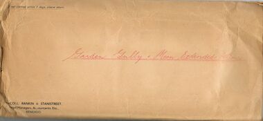
Document - MCCOLL, RANKIN AND STANISTREET COLLECTION: LEASE AGREEMENT, 24th November, 1933
... mIning... Garden Gully and Moon Extended Mines...Also in the envelope is a lease document for mining Lease No. 9993, for the Central Garden Gully Gold Mining Co. ...Also in the envelope is a lease document for mining Lease No. 9993, for the Central Garden Gully Gold Mining Co. ...Manilla Envelope containing 3 copies of a Lease agreement between John Taylor of California Gully and John Severn Barker of Jobs Gully for a company called the Garden Gully and Moon Extended Gold Mines NL. These men are the holders of an application for Gold Mining lease 10073 comprising about 90 acres in the Parishes of Yarraberb and Neilborough. The company is being formed to acquire the application for the lease and to carry out mining operations on and in the land comprised in the lease application. Dated 24th November 1933. Also in the envelope is a lease document for mining Lease No. 9993, for the Central Garden Gully Gold Mining Co. NL which includes a map of the lease. Written in pencil on the front of the lease is : allowed to lapse.gold, mining, lease agreement, gold mining, garden gully and moon extended mines, central garden gully