
Showing 9 items matching "mitcham north shopping centre"
-
 Whitehorse Historical Society Inc.
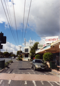
Photograph, Mitcham North Shopping Centre, 2006
... Mitcham North Shopping Centre...mitcham north shopping centre...Coloured Photo of Mitcham North Shopping Centre (opposite Park Road) looking south. ...mitcham north shopping centre shops shopping centre Coloured Photo of Mitcham North Shopping Centre (opposite Park Road) looking south. ...Coloured Photo of Mitcham North Shopping Centre (opposite Park Road) looking south. Communications towers situated on roof of a security service building. Land surveyor and chemist on right (west side ).mitcham north shopping centre, shops, shopping centre -
 Whitehorse Historical Society Inc.
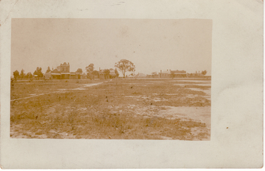
Postcard, Mitcham Shopping Centre, 1910 - 1920
... Black and white postcard of Mitcham Shopping Centre, North Side 1910 - 1920. - Cross Roads - Whitehorse and Mitcham Roads| - Prominent building is W.Morris grocer...morris w. mitcham shopping centre Black and white postcard of Mitcham Shopping Centre, North Side 1910 - 1920. - Cross Roads - Whitehorse and Mitcham Roads| - Prominent building is W.Morris grocer Mitcham Shopping Centre. ...Black and white postcard of Mitcham Shopping Centre, North Side 1910 - 1920. - Cross Roads - Whitehorse and Mitcham Roads| - Prominent building is W.Morris grocermorris w., mitcham shopping centre -
 Whitehorse Historical Society Inc.
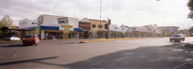
Photograph, Mitcham Shopping Centre, 1/11/2000 12:00:00 AM
... Coloured Photograph of Mitcham Shopping Centre - north side of Whitehorse Road between Britannia Mall to Mitcham Road. ...mitcham shopping centre whitehorse road mitcham britannia mall mitcham mitcham road Coloured Photograph of Mitcham Shopping Centre - north side of Whitehorse Road between Britannia Mall to Mitcham Road. ...Coloured Photograph of Mitcham Shopping Centre - north side of Whitehorse Road between Britannia Mall to Mitcham Road. Photograph taken from southern side of Whitehorse Road near the Post Office opposite Britannia Mall.mitcham shopping centre, whitehorse road mitcham, britannia mall, mitcham, mitcham road -
 Whitehorse Historical Society Inc.
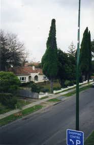
Photograph, View from Mitcham Pedestrian Bridge, 1/07/2000 12:00:00 AM
... Coloured photo from the pedestrian overpass on Whitehorse Road, Mitcham, looking north-east towards the Mitcham Shopping Centre.- North - side. ...whitehorse road mitcham pedestrian overpass Coloured photo from the pedestrian overpass on Whitehorse Road, Mitcham, looking north-east towards the Mitcham Shopping Centre.- North - side. ...Coloured photo from the pedestrian overpass on Whitehorse Road, Mitcham, looking north-east towards the Mitcham Shopping Centre.- North - side. House with Spanish taste belonged to Mr. Peake of Peake and Cox, the timber yard directly across Whitehorse Road from this house which became the new site of St.John's Roman Catholic Primary School. This house was on the corner of Whitehorse Road and Albert Street. Upon the sale of the timber yard and mill the catholic church the house was also sold to the church and was occupied as a residence for the school's teaching Sister's. (House since demolished)whitehorse road, mitcham, pedestrian overpass -
 Ringwood and District Historical Society
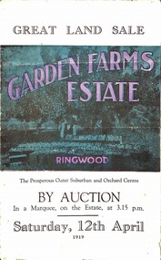
Pamphlet, G.A. Green, Auction Sale Brochure - Garden Farms Estate, Ringwood, Victoria - 1919, 1919
... shopping can be done locally. WHY RINGWOOD MUST GROW. Ringwood is a great centre and must be a greater. Two rapidly-developing railways junction here. The passengers from Ringwood Station cityward, in one year, number 250,000. Ringwood will be the terminus of the Outer Suburban Electric Eastern Railway. Its natural boundaries are the River Yarra on the North, Dandenong Creek on the South, the popular town of Croydon on the East, and the suburb of Mitcham...shopping can be done locally. WHY RINGWOOD MUST GROW. Ringwood is a great centre and must be a greater. Two rapidly-developing railways junction here. The passengers from Ringwood Station cityward, in one year, number 250,000. Ringwood will be the terminus of the Outer Suburban Electric Eastern Railway. Its natural boundaries are the River Yarra on the North, Dandenong Creek on the South, the popular town of Croydon on the East, and the suburb of Mitcham ...Multi-fold brochure advertising public auction of one-acre, 2-acre, 5-acre and 8-acre allotments in Ringwood and Bayswater on Saturday 12th April, 1919. Brochure includes terms of sale, description of subdivision features and local facilities, and photographic images of the area.Subdivison includes Canterbury Road Heathmont, Armstrong Road Heathmont, Armstrong Road Bayswater, Bungalook Road Heathmont, Bungalook Road Bayswater, and Orchard Road Bayswater. Road shown as Bayswater Road to Bayswater became Mountain Highway Bayswater. Vendor: H.E.B.Armstrong, Auctioneers: Coghill & Haughton, 79 Swanston Street Melbourne, Telephone Central 2793, in conjunction with J.B. McAlpin, Ringwood, Opposite Station, Telephone Ringwood 7. (Map) Woodcock & McCormack, Civil Engineers Architects & Surveyors, 430 Little Collins Street, Melbourne, Phone 3241 Central. MOST OF THE MONEY COMES OUT OF THE LAND. And more money can be obtained from anb acre of fruit than from an acre of any other produce. But you do not have to grow fruit on Garden Farms Estate. You can go in for - Outer Suburban Home - Market Garden - Orchard - Pig Raising - Poultry Farm - Small Dairy Farm - Small Fruits - Floral Culture - Scent and Bee Farm - Or just for a Week-end Home. RINGWOOD - THE PLACE TO LIVE. The Beautiful Ringwood District has so many natural attractions, that half a Land Agent's work is done in just showing a prospective buyer round and about. Ringwood has a pull of its own that attracts folk, proved beyond doubt by its rapid development within the last decade (spite the war). First, it is high and healthy, picturesque and undulating, convenient of access, sufficiently close to the Metropolis for City and Business folk to live at Ringwood. Its development is solid, because most of its people are industrious husbandmen, real producers, who have turned idle hills into smiling gardens. These are the kind of real people to live amongst; ones who wear out their spades. The rapidly-developing town has excellent Stores, Trade and Repair Shops Churches, Banks, Telephone Exchange, Weekly General Market, Cool Stores, and good Private and State Schools, etc.; is Electrically lit, has Metropolitan Water Supply, and generally provides so that practically all shopping can be done locally. WHY RINGWOOD MUST GROW. Ringwood is a great centre and must be a greater. Two rapidly-developing railways junction here. The passengers from Ringwood Station cityward, in one year, number 250,000. Ringwood will be the terminus of the Outer Suburban Electric Eastern Railway. Its natural boundaries are the River Yarra on the North, Dandenong Creek on the South, the popular town of Croydon on the East, and the suburb of Mitcham on the West. This is a large territory that is steadily being converted from intense culture, and then it might be called (as regards its gardens) "The Devon Territory of Victoria." ARMSTRONG ROAD. This new road traverses Garden Farms Estate from its northern boundary on the main Canterbury Road, across Dandenong Creek, to its southern boundary on the main Bayswater Road, and will provide a long-desired additional link of communication between Bayswater and Ringwood. The 1-acre building sites on Bayswater Road are within 8 minutes' walk of the Bayswater Railway Station, and the Canterbury Road frontages are only 1-1/2 miles from Ringwood Station, and 1/2 mile from the Railway Station site of Canterbury Road; therefore, the whole Estate is easy of access and there should be a large demand for land so favourably placed. (Image) Cultivation Field - Potatoes on Lot 28 (Image) Picture of Bayswater Creek Flats. (Image) View from "Korumbeen" where Mr. Armstrong lived on Garden Farms Estate. Estate outlined in white ring. (Image) Site of New Bridge over Dandenong Creek. (Image) On one of the timbered lots adjoining railway. (Image) This Dandenong Creek traveres the Estate. (Image) Main Fern Tree Gully Line bisects the Estate. -
 Melbourne Tram Museum
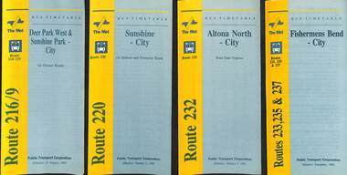
Ephemera - Timetable - bus - The Met - set of 24, The Met, 1992 & 1993
... All dated during1993 unless noted otherwise. 1 - Route 216/9 - Deer Park West & Sunshine Park - City 2 - Route 220 - Sunshine - City - 1992 3 - Route 232 - Altona North - City - 1992 4 - Route 233 - Fishermens Bend - City - 1992 5 - Route 254 - Northland Shopping Centre - City - 1992 6 - Route 256 - La Trobe Uni - City - 1992 7 - Routes 258 & 259 - Northland Shopping Centre, and La Trobe Uni - City via Eastern Freeway - 1992 8 - Route 260 etc - Deep Creek Templestow - Donvale - City 9 - Route 264 - Mitcham, Donvale City 10 - Route 265 - Deep Creek - City 11 - Route 602 - Brighton - city 12 - Route 269, 291 and 296 - Greensborough, Heidelberg & Newmans Road to Box Hill 13 - Route 272 - Warrandyte - City 14 - Route 276 & 278 - Warrandyte - City 15 - Route 284 & 270 - East Kew - City or Box Hill 16 - Route 285 - The Pines - Box Hill 17 - Route 286 & 288 - The Pines and Templestowe - Box Hill 18 - Route 290 - North Nunawading - Box Hill 19 - Route 292 etc - Box Hill, Deep Creek, Ringwood, Warrandyte 20 - Route 301, 281 315 - Ringwood, Park Orchards and Donvale - City 21 - Route 305 - Box Hill - Ringwood 22 - Route 366 & 367 - Ringwood - Croydon 23 - Route 600 - St Kilda - Brighton Beach - 1992 24 - Route 601 - Gardenvale - City - 1992...All dated during1993 unless noted otherwise. 1 - Route 216/9 - Deer Park West & Sunshine Park - City 2 - Route 220 - Sunshine - City - 1992 3 - Route 232 - Altona North - City - 1992 4 - Route 233 - Fishermens Bend - City - 1992 5 - Route 254 - Northland Shopping Centre - City - 1992 6 - Route 256 - La Trobe Uni - City - 1992 7 - Routes 258 & 259 - Northland Shopping Centre, and La Trobe Uni - City via Eastern Freeway - 1992 8 - Route 260 etc - Deep Creek Templestow - Donvale - City 9 - Route 264 - Mitcham, Donvale City 10 - Route 265 - Deep Creek - City 11 - Route 602 - Brighton - city 12 - Route 269, 291 and 296 - Greensborough, Heidelberg & Newmans Road to Box Hill 13 - Route 272 - Warrandyte - City 14 - Route 276 & 278 - Warrandyte - City 15 - Route 284 & 270 - East Kew - City or Box Hill 16 - Route 285 - The Pines - Box Hill 17 - Route 286 & 288 - The Pines and Templestowe - Box Hill 18 - Route 290 - North Nunawading - Box Hill 19 - Route 292 etc - Box Hill, Deep Creek, Ringwood, Warrandyte 20 - Route 301, 281 315 - Ringwood, Park Orchards and Donvale - City 21 - Route 305 - Box Hill - Ringwood 22 - Route 366 & 367 - Ringwood - Croydon 23 - Route 600 - St Kilda - Brighton Beach - 1992 24 - Route 601 - Gardenvale - City - 1992 Yields information about some of The Met bus services 1993 timetables The Met route 216 route 220 route 232 route 233 Route 254 route 258 Route 259 route 260 route 264 route 265 route 256 Route 602 route 269 Route 272 route 276 route 284 route 270 route 285 route 286 route 288 Route 290 route 292 route 301 route 305 route 366 route 367 route 600 route 601 Set of 24 The Met timetables, DL size, printed in two colours. ...SSet of 24 The Met bus timetables, with diagrammatic map, major stops and contact details. All dated during1993 unless noted otherwise. 1 - Route 216/9 - Deer Park West & Sunshine Park - City 2 - Route 220 - Sunshine - City - 1992 3 - Route 232 - Altona North - City - 1992 4 - Route 233 - Fishermens Bend - City - 1992 5 - Route 254 - Northland Shopping Centre - City - 1992 6 - Route 256 - La Trobe Uni - City - 1992 7 - Routes 258 & 259 - Northland Shopping Centre, and La Trobe Uni - City via Eastern Freeway - 1992 8 - Route 260 etc - Deep Creek Templestow - Donvale - City 9 - Route 264 - Mitcham, Donvale City 10 - Route 265 - Deep Creek - City 11 - Route 602 - Brighton - city 12 - Route 269, 291 and 296 - Greensborough, Heidelberg & Newmans Road to Box Hill 13 - Route 272 - Warrandyte - City 14 - Route 276 & 278 - Warrandyte - City 15 - Route 284 & 270 - East Kew - City or Box Hill 16 - Route 285 - The Pines - Box Hill 17 - Route 286 & 288 - The Pines and Templestowe - Box Hill 18 - Route 290 - North Nunawading - Box Hill 19 - Route 292 etc - Box Hill, Deep Creek, Ringwood, Warrandyte 20 - Route 301, 281 315 - Ringwood, Park Orchards and Donvale - City 21 - Route 305 - Box Hill - Ringwood 22 - Route 366 & 367 - Ringwood - Croydon 23 - Route 600 - St Kilda - Brighton Beach - 1992 24 - Route 601 - Gardenvale - City - 1992Yields information about some of The Met bus services 1993Set of 24 The Met timetables, DL size, printed in two colours.timetables, the met, route 216, route 220, route 232, route 233, route 254, route 258, route 259, route 260, route 264, route 265, route 256, route 602, route 269, route 272, route 276, route 284, route 270, route 285, route 286, route 288, route 290, route 292, route 301, route 305, route 366, route 367, route 600, route 601 -
 Whitehorse Historical Society Inc.
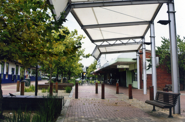
Photograph, Brittania Mall Mitcham
... Mitcham Shopping centre, begun in 1986. It affected both Edward Street and Brittania Street, part of which had to be re-routed. The guide hall in Brittania Street was removed to Halliday Park Mitcham. The development included extension of the New World Supermarket(now Coles) and a two level carpark. shops britannia mall mitcham Coloured photograph of the Britannia Mall, Mitcham taken from the north end. ...The Brittania Mall was part of a $5 million development of the Mitcham Shopping centre, begun in 1986. It affected both Edward Street and Brittania Street, part of which had to be re-routed. The guide hall in Brittania Street was removed to Halliday Park Mitcham. The development included extension of the New World Supermarket(now Coles) and a two level carpark.Coloured photograph of the Britannia Mall, Mitcham taken from the north end. Traffic in the distance is on Whitehorse Road - 2012shops, britannia mall, mitcham -
 Whitehorse Historical Society Inc.
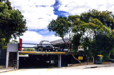
Photograph, Mitcham Shopping Centre Car Park, 2012
... mitcham shopping centre car park car parks Coloured photograph of the 2-tire car park that serves the Mitcham shops on the north side of the Whitehorse Road. ...Coloured photograph of the 2-tire car park that serves the Mitcham shops on the north side of the Whitehorse Road. Shows both levels-2012mitcham shopping centre car park, car parks -
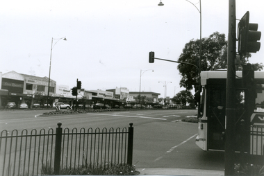 Whitehorse Historical Society Inc.
Photograph, Whitehorse Road, Mitcham, 2000
... North side of Whitehorse Road towards Mitcham Road intersection from corner of Station Street. Featured from L-R shops include Stan Russell Mens Clothing; Top floor Wing Chum Kung Fu Academy (Martial Art); Lower floor: Florist, Bryson Office Supplies, Mitcham Pharmacy and Medical Centre; Road sign - Mitcham Road - Vermont; across intersection - sign for 'Bristol Paints'....Simmenauer on the same theme. whitehorse road mitcham stan russell menswear wing chum kung fu academy florists mitcham pharmacy mitcham medical centre bristol paints bryson office supplies Black and white photograph - print and negative looking East along North side of Whitehorse Road towards Mitcham Road intersection from corner of Station Street. Featured from L-R shops ...Produced as one of a series of 24 prints commissioned by Nunawading & District Historical Society -|Theme: Intersections of Mitcham and Nunawading 2000/2001.|See also Series by P. Simmenauer on the same theme. Black and white photograph - print and negative looking East along North side of Whitehorse Road towards Mitcham Road intersection from corner of Station Street. Featured from L-R shops include Stan Russell Mens Clothing; Top floor Wing Chum Kung Fu Academy (Martial Art); Lower floor: Florist, Bryson Office Supplies, Mitcham Pharmacy and Medical Centre; Road sign - Mitcham Road - Vermont; across intersection - sign for 'Bristol Paints'.whitehorse road, mitcham, stan russell menswear, wing chum kung fu academy, florists, mitcham pharmacy, mitcham medical centre, bristol paints, bryson office supplies
