Showing 12 items matching "mount misery"
-
 Inverloch Historical Society
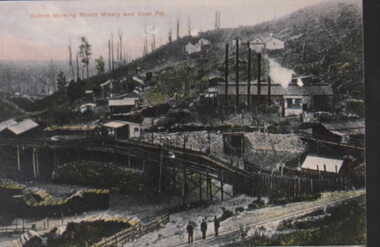
000452 Postcard - Outrim showing Mount Misery and Coal Pit - Should be Outtrim - Photocards by SGP Wonthaggi 5672 1749
... 000452 Postcard - Outrim showing Mount Misery and Coal Pit - Should be Outtrim - Photocards by SGP Wonthaggi 5672 1749...Inverloch gippsland 000452 Postcard - Outrim showing Mount Misery and Coal Pit - Should be Outtrim - Photocards by SGP Wonthaggi 5672 1749 ... -
 The Beechworth Burke Museum
Photograph
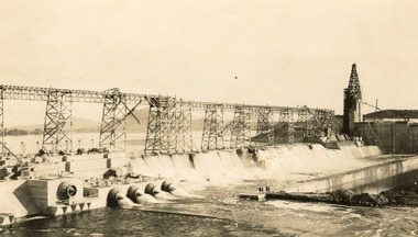
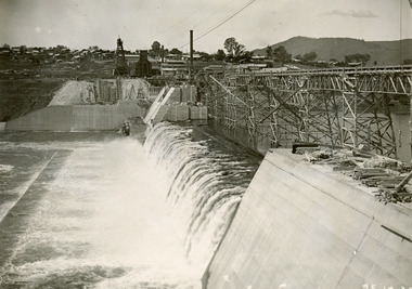
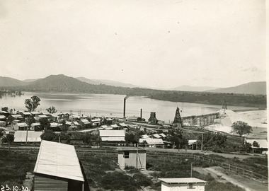
... ...Mount Misery...Mitta Mitta: Mitta Mitta is situated between Mount Welcome and Mount Misery. It is named after the river that explorers Hume and Hovell discovered in 1824. ...Mitta Mitta: Mitta Mitta is situated between Mount Welcome and Mount Misery. It is named after the river that explorers Hume and Hovell discovered in 1824. ...Taken on 25 October 1930, various houses with the Hume Dam under construction are depicted in the background. The construction of the Hume Dam took place from 1919 to 1936. At the time of construction, it was the second largest dam in the world. It was also one of the earliest civil projects developed after the Federation. Some of the Dam workers consisted of World War I veterans. Dam workers often settled their families in Mitta Junction Village and Wodonga. Archaeological surveys were completed by Austral Archaeology, which was done when the Department of Land & Water Conservation was doing work to improve Hume Dam. The archaeological report that came out of the survey recommended three sites of interest where archaeological excavation should be done: Camp Ganger’s Quarters, Stableman’s Quarters, and the Industrial Dump. The excavation uncovered artefacts. Mitta Mitta: Mitta Mitta is situated between Mount Welcome and Mount Misery. It is named after the river that explorers Hume and Hovell discovered in 1824. The town would eventually become a huge gold mining town. Mitta Mitta is called Midamodunga by the local Indigenous peoples Wodonga: Wodonga is situated on the Murray River and is part of North East Victoria. Hume and Hovell: Hamilton Hume (1979-1873) and William Hilton Hovell (1786-1875). W. H. Hovell was born in Norfolk England and Hume was born in Parramatta, New South Wales Hovell and Hume undertook an exploration journey in 1824 and thought they discovered a river, which turned out to be the Murray River. They returned home in 1825, but returned to the area in 1826 and discovered coal in the area. This photo is historically significant as it shows the Hume Dam under construction in 1930. The Dam was named after Hamilton Hume, who is an important historical figure for this area as he helped discover the area where resources were found.Sepia rectangular photograph printed unmountedReverse: 84-19-5 / 1997.3185/ Values & spillway. / When completed the wall / will be as high as the / scaffolding. [featuring trademark: kodak print]construction, houses, veterans, mitta junction village, hume dam, world war i, federation, wodonga, archaeological survey, excavation, austral archaeology, department of land & water conservation, camp ganger's quarter's, stableman's quarters, industrial dump, artefacts, mitta mitta, mount welcome, mount misery, murray river, hamilton hume, william hilton hovell, hume and hovell expedition -
 The Beechworth Burke Museum
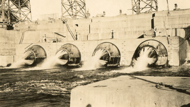
Photograph, c1930
... ...Mount Misery...Mitta Mitta: Mitta Mitta is situated between Mount Welcome and Mount Misery. It is named after the river that explorers Hume and Hovell discovered in 1824. ...Mitta Mitta: Mitta Mitta is situated between Mount Welcome and Mount Misery. It is named after the river that explorers Hume and Hovell discovered in 1824. ...Taken on 25 October 1930, various houses with the Hume Dam under construction are depicted in the background. The construction of the Hume Dam took place from 1919 to 1936. At the time of construction, it was the second largest dam in the world. It was also one of the earliest civil projects developed after the Federation. Some of the Dam workers consisted of World War I veterans. Dam workers often settled their families in Mitta Junction Village and Wodonga. Archaeological surveys were completed by Austral Archaeology, which was done when the Department of Land & Water Conservation was doing work to improve Hume Dam. The archaeological report that came out of the survey recommended three sites of interest where archaeological excavation should be done: Camp Ganger’s Quarters, Stableman’s Quarters, and the Industrial Dump. The excavation uncovered artefacts. Mitta Mitta: Mitta Mitta is situated between Mount Welcome and Mount Misery. It is named after the river that explorers Hume and Hovell discovered in 1824. The town would eventually become a huge gold mining town. Mitta Mitta is called Midamodunga by the local Indigenous peoples Wodonga: Wodonga is situated on the Murray River and is part of North East Victoria. Hume and Hovell: Hamilton Hume (1979-1873) and William Hilton Hovell (1786-1875). W. H. Hovell was born in Norfolk England and Hume was born in Parramatta, New South Wales Hovell and Hume undertook an exploration journey in 1824 and thought they discovered a river, which turned out to be the Murray River. They returned home in 1825, but returned to the area in 1826 and discovered coal in the area.This photo is historically significant as it shows the Hume Dam under construction in 1930. The Dam was named after Hamilton Hume, who is an important historical figure for this area as he helped discover the area where resources were found.Sepia rectangular photograph printed unmountedReverse: 84-19-2/ 1997.3188/ These are the four / release valves they are / not always open (illegible) this / when closed the water flows / over the spillway. [featuring trademark: kodak print] photograph number: 354construction, houses, veterans, mitta junction village, hume dam, world war i, federation, wodonga, archaeological survey, excavation, austral archaeology, department of land & water conservation, camp ganger's quarter's, stableman's quarters, industrial dump, artefacts, mitta mitta, mount welcome, mount misery, murray river, hamilton hume, william hilton hovell, hume and hovell expedition -
 The Beechworth Burke Museum
Photograph, 25 October 1930
... ...Mount Misery...Mitta Mitta: Mitta Mitta is situated between Mount Welcome and Mount Misery. It is named after the river that explorers Hume and Hovell discovered in 1824. ...Mitta Mitta: Mitta Mitta is situated between Mount Welcome and Mount Misery. It is named after the river that explorers Hume and Hovell discovered in 1824. ...Taken on 25 October 1930, various houses with the Hume Dam under construction are depicted in the background. The construction of the Hume Dam took place from 1919 to 1936. At the time of construction, it was the second largest dam in the world. It was also one of the earliest civil projects developed after the Federation. Some of the Dam workers consisted of World War I veterans. Dam workers often settled their families in Mitta Junction Village and Wodonga. Archaeological surveys were completed by Austral Archaeology, which was done when the Department of Land & Water Conservation was doing work to improve Hume Dam. The archaeological report that came out of the survey recommended three sites of interest where archaeological excavation should be done: Camp Ganger’s Quarters, Stableman’s Quarters, and the Industrial Dump. The excavation uncovered artefacts. Mitta Mitta: Mitta Mitta is situated between Mount Welcome and Mount Misery. It is named after the river that explorers Hume and Hovell discovered in 1824. The town would eventually become a huge gold mining town. Mitta Mitta is called Midamodunga by the local Indigenous peoples Wodonga: Wodonga is situated on the Murray River and is part of North East Victoria. Hume and Hovell: Hamilton Hume (1979-1873) and William Hilton Hovell (1786-1875). W. H. Hovell was born in Norfolk England and Hume was born in Parramatta, New South Wales Hovell and Hume undertook an exploration journey in 1824 and thought they discovered a river, which turned out to be the Murray River. They returned home in 1825, but returned to the area in 1826 and discovered coal in the area.This photo is historically significant as it shows the Hume Dam under construction in 1930. The Dam was named after Hamilton Hume, who is an important historical figure for this area as he helped discover the area where resources were found.Sepia rectangular photograph printed unmountedReverse: 84-19-6/ 1997.3187/ The spillway [featuring trademark: kodak print] construction, houses, veterans, mitta junction village, hume dam, world war i, federation, wodonga, archaeological survey, excavation, austral archaeology, department of land & water conservation, camp ganger's quarter's, stableman's quarters, industrial dump, artefacts, mitta mitta, mount welcome, mount misery, murray river, hamilton hume, william hilton hovell, hume and hovell expedition -
 The Beechworth Burke Museum
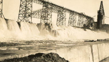
Photograph, 25 October 1930
... ...Mount Misery...Mitta Mitta: Mitta Mitta is situated between Mount Welcome and Mount Misery. It is named after the river that explorers Hume and Hovell discovered in 1824. ...Mitta Mitta: Mitta Mitta is situated between Mount Welcome and Mount Misery. It is named after the river that explorers Hume and Hovell discovered in 1824. ...Taken on 25 October 1930, various houses with the Hume Dam under construction are depicted in the background. The construction of the Hume Dam took place from 1919 to 1936. At the time of construction, it was the second largest dam in the world. It was also one of the earliest civil projects developed after the Federation. Some of the Dam workers consisted of World War I veterans. Dam workers often settled their families in Mitta Junction Village and Wodonga. Archaeological surveys were completed by Austral Archaeology, which was done when the Department of Land & Water Conservation was doing work to improve Hume Dam. The archaeological report that came out of the survey recommended three sites of interest where archaeological excavation should be done: Camp Ganger’s Quarters, Stableman’s Quarters, and the Industrial Dump. The excavation uncovered artefacts. Mitta Mitta: Mitta Mitta is situated between Mount Welcome and Mount Misery. It is named after the river that explorers Hume and Hovell discovered in 1824. The town would eventually become a huge gold mining town. Mitta Mitta is called Midamodunga by the local Indigenous peoples Wodonga: Wodonga is situated on the Murray River and is part of North East Victoria. Hume and Hovell: Hamilton Hume (1979-1873) and William Hilton Hovell (1786-1875). W. H. Hovell was born in Norfolk England and Hume was born in Parramatta, New South Wales Hovell and Hume undertook an exploration journey in 1824 and thought they discovered a river, which turned out to be the Murray River. They returned home in 1825, but returned to the area in 1826 and discovered coal in the area.This photo is historically significant as it shows the Hume Dam under construction in 1930. The Dam was named after Hamilton Hume, who is an important historical figure for this area as he helped discover the area where resources were found.Black and white rectangular photograph printer unmountedReverse: 84-20-1/ 1997.3147construction, houses, veterans, mitta junction village, hume dam, world war i, federation, wodonga, archaeological survey, excavation, austral archaeology, department of land & water conservation, camp ganger's quarter's, stableman's quarters, industrial dump, artefacts, mitta mitta, mount welcome, mount misery, murray river, hamilton hume, william hilton hovell, hume and hovell expedition -
 The Beechworth Burke Museum
Photograph, 25 October 1930
... ...Mount Misery...Mitta Mitta: Mitta Mitta is situated between Mount Welcome and Mount Misery. It is named after the river that explorers Hume and Hovell discovered in 1824. ...Mitta Mitta: Mitta Mitta is situated between Mount Welcome and Mount Misery. It is named after the river that explorers Hume and Hovell discovered in 1824. ...Taken on 25 October 1930, various houses with the Hume Dam under construction are depicted in the background. The construction of the Hume Dam took place from 1919 to 1936. At the time of construction, it was the second largest dam in the world. It was also one of the earliest civil projects developed after the Federation. Some of the Dam workers consisted of World War I veterans. Dam workers often settled their families in Mitta Junction Village and Wodonga. Archaeological surveys were completed by Austral Archaeology, which was done when the Department of Land & Water Conservation was doing work to improve Hume Dam. The archaeological report that came out of the survey recommended three sites of interest where archaeological excavation should be done: Camp Ganger’s Quarters, Stableman’s Quarters, and the Industrial Dump. The excavation uncovered artefacts. Mitta Mitta: Mitta Mitta is situated between Mount Welcome and Mount Misery. It is named after the river that explorers Hume and Hovell discovered in 1824. The town would eventually become a huge gold mining town. Mitta Mitta is called Midamodunga by the local Indigenous peoples Wodonga: Wodonga is situated on the Murray River and is part of North East Victoria. Hume and Hovell: Hamilton Hume (1979-1873) and William Hilton Hovell (1786-1875). W. H. Hovell was born in Norfolk England and Hume was born in Parramatta, New South Wales Hovell and Hume undertook an exploration journey in 1824 and thought they discovered a river, which turned out to be the Murray River. They returned home in 1825, but returned to the area in 1826 and discovered coal in the area. This photo is historically significant as it shows the Hume Dam under construction in 1930. The Dam was named after Hamilton Hume, who is an important historical figure for this area as he helped discover the area where resources were found. Black and white rectangular photograph printer unmountedReverse: 1997.3145/ 84-20-2construction, houses, veterans, mitta junction village, hume dam, world war i, federation, wodonga, archaeological survey, excavation, austral archaeology, department of land & water conservation, camp ganger's quarter's, stableman's quarters, industrial dump, artefacts, mitta mitta, mount welcome, mount misery, murray river, hamilton hume, william hilton hovell, hume and hovell expedition -
 Federation University Historical Collection
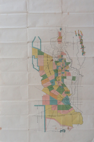
Plan, Berry Bank Estates
... ...mount misery creek...Gift of the Squire Family berry bank estates mining happy valley lake rosine estates strathvean estates proprietary w. luplaupitfield plateau british banner federal mint moller morrow south pitfield consols east banner new lallah rookh bull dog company mindai j. morpoh poliah f. j. morrow piggoreet east w. m. acheson grand trunk field's claim south grand trunk south grand trunk woady yalloak creek mount misery creek fitzpatric's creek illabrook creek great western mount bute syndicate narringhill creek little woady yalloak creek piggoreet east preemptive right southern birthday new birthday prince of wales collins brassey birthday howarth's lead w. price royal birthday a. clinton victoria express patons williams fancy hennessy queen of the south n pandora proprietary gold estate lyonbank lease rowe's southern rowe's extended w. t. rowe wallinduc company glenfine horseshoe company rowe's glenfine junction wallinduc syndicate pitfield estates rowe's estate southern glenfine h. fields christies & fields balmoral company glenfine united hallett great glenfine rowe consuls nicholls london & melbourne gold mine j. w. pascoe christies glenfine central j. king j. durston great western extended oswald woadyyaloak berringa squire Plan of Berry Bank Estates. ...This plan is associated with former Ballarat School of Mines Student Richard Squire (1875-1876). Gift of the Squire FamilyPlan of Berry Bank Estates. Coloured plan on cream paperberry bank estates, mining, happy valley, lake rosine estates, strathvean estates proprietary, w. luplaupitfield plateau, british banner, federal mint, moller, morrow, south pitfield consols, east banner, new lallah rookh, bull dog company, mindai, j. morpoh, poliah, f. j. morrow, piggoreet east, w. m. acheson, grand trunk, field's claim south grand trunk, south grand trunk, woady yalloak creek, mount misery creek, fitzpatric's creek, illabrook creek, great western, mount bute syndicate, narringhill creek, little woady yalloak creek, piggoreet east preemptive right, southern birthday, new birthday, prince of wales, collins, brassey birthday, howarth's lead, w. price, royal birthday, a. clinton, victoria express, patons, williams fancy, hennessy, queen of the south, n, pandora proprietary gold estate, lyonbank lease, rowe's southern, rowe's extended, w. t. rowe, wallinduc company, glenfine horseshoe company, rowe's glenfine junction, wallinduc syndicate, pitfield estates, rowe's estate, southern glenfine, h. fields, christies & fields, balmoral company, glenfine united, hallett, great glenfine, rowe consuls, nicholls, london & melbourne gold mine, j. w. pascoe, christies, glenfine central, j. king, j. durston, great western extended, oswald, woadyyaloak, berringa, squire -
 Sunshine and District Historical Society Incorporated
Photograph - AL Harvestor 1920s
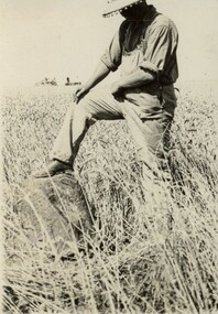
... Two photos of an AL Harvester in a crop supposedly at Mount Misery in the early 1920s. Mr Jack Jackson and two other persons in one photo and Mr Jack Jackson on machinery in other photo Illustrates crop conditions and rock to be missed by machine...Farm Machinery Two photos of an AL Harvester in a crop supposedly at Mount Misery in the early 1920s. Mr Jack Jackson and two other persons in one photo and Mr Jack Jackson on machinery in other photo Illustrates crop conditions and rock to be missed by machine AL Harvestor 1920s Photograph AL Harvestor 1920s ...Two photos of an AL Harvester in a crop supposedly at Mount Misery in the early 1920s. Mr Jack Jackson and two other persons in one photo and Mr Jack Jackson on machinery in other photo Illustrates crop conditions and rock to be missed by machinefarm machinery -
 Federation University Historical Collection
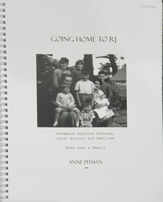
Book, Anne Pitman, Going Home to RJ: Rokewood Junction Stories, Local History and Families: More than a Memoir, 2023
... Mount Helen goldfields History of the town of Rokewood Junction and the associated families. Rokewood Rokewood Junction Chatham Kurus-a-ruc Henry Pitman Elizabeth Pitman William Henry Pitman Rokewood junction state School Commeralghip Paddy's Gully Bridge Illabrook Conereyalk Woady Yalloak Creek Mt Misery Creek Paddy's Gully Diggings. ...Beverley Chatham ( daughter of Arthur Chatham) suggested that Commerlghip refers to Watering holes and underground springs found in the Little Woady Yallok and Mt Misery Creeks. Rokewood Junction was proclaimed a township in 1885, originally known as a gold-mining township called Paddy's Gully Diggings.Ringbound publication of 212 pagesnon-fictionBeverley Chatham ( daughter of Arthur Chatham) suggested that Commerlghip refers to Watering holes and underground springs found in the Little Woady Yallok and Mt Misery Creeks. Rokewood Junction was proclaimed a township in 1885, originally known as a gold-mining township called Paddy's Gully Diggings. rokewood, rokewood junction, chatham, kurus-a-ruc, henry pitman, elizabeth pitman, william henry pitman, rokewood junction state school, commeralghip, paddy's gully bridge, illabrook, conereyalk, woady yalloak creek, mt misery creek, paddy's gully diggings., dereel, pitfield, wadawurrung, william rutland, squatters, aborigines, aboriginal, charlotte walsh, maurice walsh, julie pitman, ben liston, sheep and wool, george hawkins, natthew wakeling, christopher moody, mt misery goldfield, john bower, mary bower, hyslop's hotel, cumberland store, jane hyslop, edward collyer, jospeh gladstone, lucas's bakery, henry batty, william young, ellen rigby, chinese, joseph anguey, eliza anguey, murder of thomas ulick burke, william achultze, william schiltze, nicholas grenfell, tomas bramley murder, emily malhoff, drowning, ah lin, eliza richards, luisa bupell, eleanor holmes, rachel holmes, joseph holloway, noah holloway, thomas faulkner, robert eli hearn, george todhunter briggs, john robinson fairweather, rokewood common, edward bussell, louisa bussell, irving rachinger, john chatham, doris chatham, peter chatham, jack chatham, imogen chatham, domenico rizzoli, mary rizzoli, rokewood junction railway line, illabrook football and netball club, cape clear, red cross, keith annear, fire brigade, rokewood junction post office, len aarons, dereel pre-emptive right, rokewood junction avenue of honour, arthur chatham -
 Federation University Historical Collection
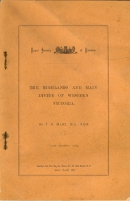
Booklet, Thomas Stephen Hart, The Highlands and Main Divide of Western Victoria, 1907, 12/12/1907
... Mount Helen goldfields Thomas S. Hart was a teacher at the Ballarat School of Mines, and a member of the Ballarat Field Naturalists Club thomas hart thomas s. hart ballarat school of mines ballarat field naturalists club royal society of victoria western victoria ballarat great dividing range mt william volcano volcanic plains waterways lal lal basin yarrowee creek ballarat common lava flow wendouree warrenheip ballarat plateau mt elephant grampians t.s. hart mt buangor mt beckworth mt misery mt bolton lal lal iron ored mt ararat mt wiliam mt cole burrumbeet mt warrenheip daylesford waubra ercildoun gap smythesdale lal lal falls parwan valley burrumbeet creek staffordshire reef pyranees bacchus marsh rowsley fault ben nevis avoca hill landsborough hill mt blowhard weatherboard mclean's hill Fyan's Creek thomas stephen hart lal lal Article with illustrations published by the Royal Society of Victoria by Thomas S. ...Thomas S. Hart was a teacher at the Ballarat School of Mines, and a member of the Ballarat Field Naturalists ClubArticle with illustrations published by the Royal Society of Victoria by Thomas S. Hart. The following plates are included: Fig 1. The Main Divide and some of the transverse ridges Fig 2. Hills on and near the Divide at the Ercildoun and Ascot Gaps Fig. 3. Profile of the Divide at Ascot Gap. Fig. 4. Sketch of the Hills west and north-west from Mt Buninyong - - The divide in Ascot Gap from Mt Blowhard (Serra Range, Mt William, Mt Ararat, Larne Gerin, Ben Major, Mt Cole, Mt Misery, Mt Bolton) Fig. 5. Diagram to illustrate the possible courses of the leads south of the present Divide - Burrumbeet Basin (Smythesdale, Ballarat, Lal Lal , Mt Doran, egerton, Parwan Creet, Rowsley Fault, Eastern Plateau) Fig. 6. Diagramatic cross section of the grampians, south of Hall's Gap. Profile of the Pyranees, from maiden Hill - Diagramatic Section of the Grampians south of Hall's Gap. (Mt Cole, Mt Mitchell, Ben Major, Ben More, Avoca Hill, Hall's Gap.) Fig. 7. Profile of the Pyrenees as seen from Maiden Hill near Waubra.thomas hart, thomas s. hart, ballarat school of mines, ballarat field naturalists club, royal society of victoria, western victoria, ballarat, great dividing range, mt william, volcano, volcanic plains, waterways, lal lal basin, yarrowee creek, ballarat common, lava flow, wendouree, warrenheip, ballarat plateau, mt elephant, grampians, t.s. hart, mt buangor, mt beckworth, mt misery, mt bolton, lal lal iron ored, mt ararat, mt wiliam, mt cole, burrumbeet, mt warrenheip, daylesford, waubra, ercildoun gap, smythesdale, lal lal falls, parwan valley, burrumbeet creek, staffordshire reef, pyranees, bacchus marsh, rowsley fault, ben nevis, avoca hill, landsborough hill, mt blowhard, weatherboard, mclean's hill, fyan's creek, thomas stephen hart, lal lal -
 Narre Warren and District Family History Group
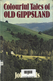
Book, John Wells, Colourful tales of old Gippsland, 2003
... .) -- History Cobb and Co. 64 tales of the Gippsland area, including stories about Mount Misery, the Beaconsfield school, the Vieusseux family, Nellie Melba. x, 192 p.; 21 cm Colourful tales of old Gippsland Book John Wells Landmark Press ...64 tales of the Gippsland area, including stories about Mount Misery, the Beaconsfield school, the Vieusseux family, Nellie Melba.x, 192 p.; 21 cmnon-fiction64 tales of the Gippsland area, including stories about Mount Misery, the Beaconsfield school, the Vieusseux family, Nellie Melba.gippsland region (vic.) -- history, cobb and co. -
 Merri-bek City Council
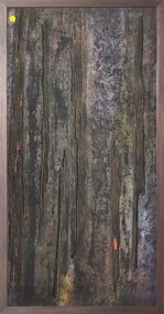
Mixed media - Callistemon charcoal and ink on marine ply, Brian McKinnon, Bush Fire I “Redgum Sleeper”, 2019
... McKinnon grew up in a Geraldton fringe camp named Blood Alley, which was at the foot of Mount Misery. Many residents of such camps were acutely aware of being alienated from the spaces created by the colonisers over their traditional homelands, and of only being able to look in from the fringes. ...