Showing 6 items matching "mount tarrengower"
-
 Lions Club of Maldon Inc.
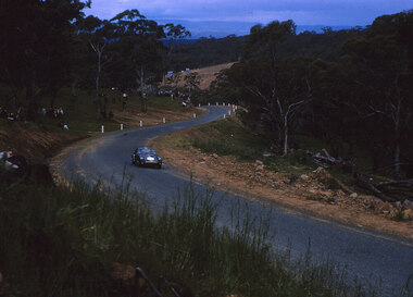
Photographs, Tarrangower Hill Climb, Circa 1970
... ...mount tarrengower...Mount Tarrengower Road, Maldon, Victoria, Australia...Lions Club of Maldon Inc. 61-63 High St Maldon goldfields tarrengower hill climb mount tarrengower Set of 14 Slides containing images taken at the Tarrengower Hill Climb Event. ...Set of 14 Slides containing images taken at the Tarrengower Hill Climb Event. Photographs Taken By Ken Bolitho, Taken from slides.tarrengower hill climb, mount tarrengower -
 Victorian Aboriginal Corporation for Languages
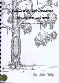
Book, John Tully, Djadja Wurrung language of Central Victoria : including place names, 1997
... ...Mount Tarrengower...Victorian Aboriginal Corporation for Languages 33 Saxon Street Brunswick melbourne Djadja Wurrung Central Victoria Mount Franklin Mount Tarrengower Mount Kooyoora Mount Moliagul Loddon River Dunolly Yuinhup King Tommy place names grammar Maps, b&w illustrations, word lists A dictionary of the Djadja Wurrung language including a short introduction with pronunciation and grammatical information. ...A dictionary of the Djadja Wurrung language including a short introduction with pronunciation and grammatical information. Includes Djadja Wurrung-English and English-Djadja Wurrung sections, and a section on Djadja Wurrung placenames.Maps, b&w illustrations, word listsdjadja wurrung, central victoria, mount franklin, mount tarrengower, mount kooyoora, mount moliagul, loddon river, dunolly, yuinhup, king tommy, place names, grammar -
 Federation University Historical Collection
Book, Maldon Historic Reserve Management Plan, 1989, 1989
... ...mount tarrengower...Barker Library (top floor) Mount Helen goldfields This book was prepared by the Royal Botanic Gardens, Mebourne maldon geology flora vermin parkin's reef derby hill beehive reef long gully union hill mount tarrengower eaglehawk gully porcupine flat neggetty range peg leg gully sandy creek smiths creek landscape Soft covered report of 83 pages, including 10 folded leaves of plates , and 11 maps (some coloured). ...This book was prepared by the Royal Botanic Gardens, Mebourne Soft covered report of 83 pages, including 10 folded leaves of plates , and 11 maps (some coloured). maldon, geology, flora, vermin, parkin's reef, derby hill, beehive reef, long gully, union hill, mount tarrengower, eaglehawk gully, porcupine flat, neggetty range, peg leg gully, sandy creek, smiths creek, landscape -
 Bendigo Historical Society Inc.
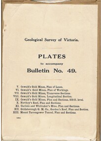
Book - MCCOLL, RANKIN AND STANISTREET COLLECTION: PLATES TO ACCOMPANY BULLETIN NO.49 MALDON GEOLOGICAL SURVEY OF VICTORIA
... Gordon's Reef, Plan & Section. XIII. Mount Tarrengower Tunnel Plan & Section....Gordon's Reef, Plan & Section. XIII. Mount Tarrengower Tunnel Plan & Section. Book MCCOLL, RANKIN AND STANISTREET COLLECTION: PLATES TO ACCOMPANY BULLETIN NO.49 MALDON GEOLOGICAL SURVEY OF VICTORIA ...Book; Brown paper containers with plates (& maps) to accompany bulletin No49 of geological survey of Victoria. V Oswalds G.M. Plan of lease. VI. Oswalds G. M. Plan of workings. VII. Oswalds G. M. Transverse Sect. VIII. Oswalds G. M. Longit. Section. IX. Oswalds G. M. Plan & Sect. 500ft. Level. X. Northey's Reef plan & sections. XI. Carlisle and Whittaker's Mine Plan & Sections.XII. Goldsborough G. M. Co. Gordon's Reef, Plan & Section. XIII. Mount Tarrengower Tunnel Plan & Section.MCCOLL RANKIN & STANISTREETorganisation, industry, surveys, mccoll rankin & stanistreet -
Federation University Historical Collection
Book, Wendy Jacobs et al, Maldon Conservation Study, 1977, 1977
... Barker Library (top floor) Mount Helen goldfields conservation maldon planning john templeton porcupine flat tarrengower mining architecture town and country planning board Wendy Jacobs Miles Lewis Elizabeth Vines Brown soft covered book of 94 pages. ...Brown soft covered book of 94 pages. It includes pull out maps and plans. conservation, maldon, planning, john templeton, porcupine flat, tarrengower, mining, architecture, town and country planning board, wendy jacobs, miles lewis, elizabeth vines -
Victorian Aboriginal Corporation for Languages
Book, C C Culvenor, The boundaries of the Mount Franklin Aboriginal Reserve, 1992
... Franklin Aboriginal Reserve The five mile radius The Tarrengower challenge Provisional boundaries Survey of the Reserve Breakup of the Reserve References Appendices. The boundaries of the Mount ..."This enquiry into the boundaries of the Mount Franklin Aboriginal Reserve had its origins in the preparation of a biography of geologist Thomas Smith of Sandon, which raised queries about Boundary Gully Road, Parkers Gully and the location in that vicinity of the Reserve boundary. At a subsequent meeting of the Daylesford Historical Society, commemorating the 150th anniversary of the founding of the Aboriginal Reserve at Franklinford in 1841, it became clear that the actual boundaries were only poorly known ... A search for information srouces in Melbourne and Sydney did not produce an overall Plan, but it is hoped that the material obtained will present a sufficiently accurate picture to be useful to other local historians and be of some interest also to the general reader" --Preface. Contents: The boundaries of the Mt. Franklin Aboriginal Reserve The five mile radius The Tarrengower challenge Provisional boundaries Survey of the Reserve Breakup of the Reserve References Appendices.maps, b&w illustrations, b&w photographsmount franklin