
Showing 13 items matching "mt dandenong store"
-
 Mt Dandenong & District Historical Society Inc.
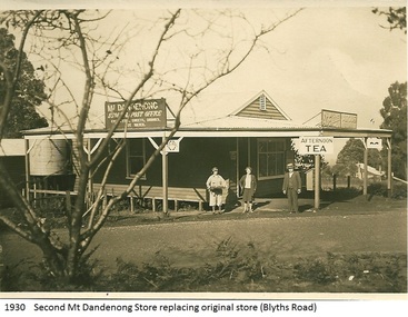
Photograph, Mt Dandenong Store, 1930
... Mt Dandenong Store......Mt Dandenong Store...Image shows the Mt Dandenong Store and Post Office that replaced the former Post office and Store that was located on the corner of Old Coach and Farndons Roads. ...Donated as a jpeg digital image that shows the Mt Dandenong Store on the corner of Helen Street and the Main Road in 1930. ...Front of image: 1930 Second Mt Dandenong Store replacing original store (Blyths Road)... Post Office Store Mt Dandenong Store Main Road Front of image: 1930 Second Mt Dandenong Store replacing original store (Blyths Road) Donated as a jpeg digital image that shows the Mt Dandenong Store on the corner of Helen Street and the Main Road in 1930. ...Image shows the Mt Dandenong Store and Post Office that replaced the former Post office and Store that was located on the corner of Old Coach and Farndons Roads. The store relocated following the opening of the new Main Road in 1926. The store pictured was on the corner of Helen Street and the Main Road. The image was taken in 1930. The photograph was taken by a member of the Dower family.Donated as a jpeg digital image that shows the Mt Dandenong Store on the corner of Helen Street and the Main Road in 1930. Two women and a man are standing at the front. Signs advertising the Store & Post Office, Age and Argus are clearly visible on top of the verandah.Front of image: 1930 Second Mt Dandenong Store replacing original store (Blyths Road)mt dandenong, post office, store, mt dandenong store, main road -
 Mt Dandenong & District Historical Society Inc.
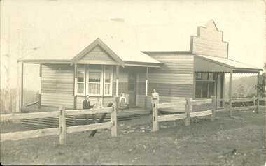
Photograph, Mt Dandenong Store, c1912
... Mt Dandenong Store...Mt Dandenong...Mt Dandenong Store...The Mt Dandenong Post Office & Store was originally built by Will Dower. ...The Mt Dandenong Post Office & Store was originally built by Will Dower. ...The Mt Dandenong Post Office & Store was originally built by Will Dower. The house and shop was built in 1912 and staffed by Ruby and Ada Dower. It became the Post Office in 1917 when Lil Badenhop sold her business following the death of her daughter Myrtle. The Post Office and Store closed in 1926 when the new premises opened on the Main Road.Black & white photograph of Dower's house and shop built on the corner of Old Coach Road and Farndons Road in Mt Dandenong. A man, woman and two children are in the foreground. Donated as a jpeg digital image.dower, will dower, mt dandenong, mt dandenong store, mt dandenong post office, mount dandenong post office, lil badenhop -
 Mt Dandenong & District Historical Society Inc.
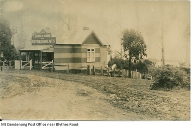
Photograph, Mt Dandenong Post Office Near Blythes Road
... Mt Dandenong...Mt Dandenong School...Mt Dandenong Store...The Mt Dandenong Post Office & Store was originally built by Will Dower. ...The Mt Dandenong Post Office & Store was originally built by Will Dower. ...The Mt Dandenong Post Office & Store was originally built by Will Dower. The house and shop was built in 1912 and staffed by Ruby and Ada Dower. It became the Post Office in 1917 when Lil Badenhop sold her business following the death of her daughter Myrtle. The Post Office and Store closed in 1926 when the new premises opened on the Main Road.Black and white photograph of Dower's house and shop built on the corner of Old Coach Road and Farndons Road in Mt Dandenong. A boy with a bicycle can be seen at the LHS edge of the photograph and the Mt Dandenong State School building directly behind the shop.dower, will dower, mt dandenong, mt dandenong school, mt dandenong store, mt dandenong post office, ruby dower, ada dower -
 Ringwood and District Historical Society
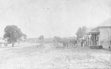
Photograph, Original Blood Bros. store, Ringwood - Mt. Dandenong Rd. looking to Whitehorse Rd. c.1900
... Original Blood Bros. store, Ringwood - Mt. Dandenong Rd. looking to Whitehorse Rd. c.1900....Written on backing sheet, "Original Blood Bros. store, Ringwood - Mt. Dandenong Rd. looking to Whitehorse Rd. ...Written on backing sheet, "Original Blood Bros. store, Ringwood - Mt. Dandenong Rd. looking to Whitehorse Rd. ...Written on backing sheet, "Original Blood Bros. store, Ringwood - Mt. Dandenong Rd. looking to Whitehorse Rd. Possibly Club Hotel on left and Blood Store late J. Skerrett." c1900. -
 Ringwood and District Historical Society
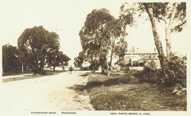
Photograph, Mount Dandenong Road, Ringwood East, c.1925. Club Hotel on right, Skerrett's Store on left
... Mt. Dandenong Rd., Ringwood East, c.1925" Written on backing sheet of an enlargement, "Mt. Dand. Rd., Skerrett's Store (Darsons) on left. c1925"....Mt. Dandenong Rd., Ringwood East, c.1925" Written on backing sheet of an enlargement, "Mt. Dand. Rd., Skerrett's Store (Darsons) on left. c1925". ...Typed below photograph, "Mt. Dandenong Rd., Ringwood East, c.1925" Written on backing sheet of an enlargement, "Mt. Dand. Rd., Skerrett's Store (Darsons) on left. c1925". -
 Mt Dandenong & District Historical Society Inc.
Photograph, Walker's LOT 2
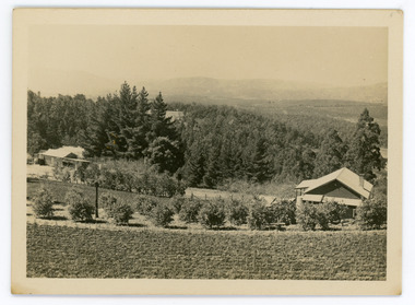
... The building over the road on the left hand side is the corn and produce store built by Edward John Price (son of Edward Joseph Price) to capitalise on the CRB Road cutting through the Price farm. John Lundy-Clarke grew up in the Kalorama/Mt Dandenong area and later in life (1972-74) began to write a comprehensive history of the area working from an original settlement map in an effort to cover all areas....The building over the road on the left hand side is the corn and produce store built by Edward John Price (son of Edward Joseph Price) to capitalise on the CRB Road cutting through the Price farm. John Lundy-Clarke grew up in the Kalorama/Mt Dandenong area and later in life (1972-74) began to write a comprehensive history of the area working from an original settlement map in an effort to cover all areas. ...Harry Walker's property would have been run by his son William in 1922. When the CRB Road cut through the property William planted plum trees on the opposite side. These are visible in this photo. An extensive raspberry crop is in the foreground. The building over the road on the left hand side is the corn and produce store built by Edward John Price (son of Edward Joseph Price) to capitalise on the CRB Road cutting through the Price farm. John Lundy-Clarke grew up in the Kalorama/Mt Dandenong area and later in life (1972-74) began to write a comprehensive history of the area working from an original settlement map in an effort to cover all areas.Small black and white postcard showing a crop in foreground with a house to the right. A road passes through the centre with a house on the left on the opposite side of the road. A view to the ranges in the distance. A handwritten description on reverse by John Lundy-Clarke.View at Kalorama. View over LOT 2 (Walkers) 1922.harry walker, william walker, crb road, raspberry, edward john price, edward joseph price, produce store, store -
 Mt Dandenong & District Historical Society Inc.
Photograph, Edward John Price 1973
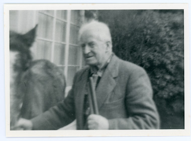
... Mt Dandenong area and later in life (1972-74) began to write a comprehensive history of the district working from an original settlement map in an effort to cover all areas. Edward John Price (Ted)(1899-1974) was the third child of Edward Joseph and Annie Price. He lived a very industrious life in the area. When the new CRB road cut through the family land Edward John established a Corn and Produce store...Mt Dandenong area and later in life (1972-74) began to write a comprehensive history of the district working from an original settlement map in an effort to cover all areas. Edward John Price (Ted)(1899-1974) was the third child of Edward Joseph and Annie Price. He lived a very industrious life in the area. When the new CRB road cut through the family land Edward John established a Corn and Produce store ...John Lundy-Clarke grew up in the Kalorama/Mt Dandenong area and later in life (1972-74) began to write a comprehensive history of the district working from an original settlement map in an effort to cover all areas. Edward John Price (Ted)(1899-1974) was the third child of Edward Joseph and Annie Price. He lived a very industrious life in the area. When the new CRB road cut through the family land Edward John established a Corn and Produce store on a level area adjoining the new road . Along with his brother Charlie, Ted took up road contracting and formed Grange Road in 1923. They also took up contracts to metal the CRB road between The Gap and Olinda. Edward John married Myra Wilson in 1930. They lived in the first brick home built in the district. They had two sons, Edward Joseph 2nd and Alan.Black and white photograph showing an old man dressed in a jacket holding the reins of a horse. Reverse of photograph has handwritten description by John Lundy-Clarke.Edward John Price 1973. Son of Edward Joseph & Annie Ada nee Ross. Born 1899 died 1974. Farmer, Carrier, Sawmiller, Contractor, Quarry Owner, Shop Proprietor (Kew Junction 1935). Father of Alan & Edward J.edward john price, myra wilson, edward joseph price, annie price, alan price, charles price, grange road, crb road -
 Mt Dandenong & District Historical Society Inc.
Photograph, Home and Shop of Edward Joseph Price
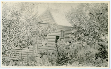
... On Front STORE MT DANDENONG On Reverse Home and Shop of Edward Joseph Price LOT 1 SECT 1 erected in 1908 on site of earlier dwelling from which goods had been sold without a special room for shop. ...The house faced Ridge Road. edward joseph price store shop On Front STORE MT DANDENONG On Reverse Home and Shop of Edward Joseph Price LOT 1 SECT 1 erected in 1908 on site of earlier dwelling from which goods had been sold without a special room for shop. ...John Lundy-Clarke grew up in the Kalorama/Mt Dandenong area and later in life (1972-74) began to write a comprehensive history of the district working from an original settlement map in an effort to cover all areas. Edward Joseph Price was the first settler to take up a lot (Lot 1, Section 1) in the Village Settlement. He built a slab hut and brought up his family in 1896. This photograph shows a newer home built in 1908. It had a section used as a shop and also had a large room built that was to be used for public gatherings. Health department regulations led to this being impossible. The house faced Ridge Road.Black and white close up photograph showing a building made from wooden boards with trees in the front. Reverse of photograph has handwritten description by John Lundy-Clarke.On Front STORE MT DANDENONG On Reverse Home and Shop of Edward Joseph Price LOT 1 SECT 1 erected in 1908 on site of earlier dwelling from which goods had been sold without a special room for shop. In picture the room on the extreme left was bedroom for boys Charlie and Ted (Edward John). Under the gable was a large room planned for public use but never used owing to Health Department Regulations. The narrow door (open) and window were the shop which was the district’s first newsagency. Window behind leaves at right was the kitchen. 1908-1912. Gabled portion is now part of home “Mirra Laken” 1975edward joseph price, store, shop -
 Mt Dandenong & District Historical Society Inc.
Photograph
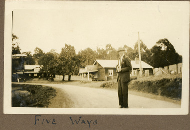
... Mt Dandenong Tourist Road). The date would be late 1920s. The building directly behind the man is a General Store that became a bank and is now a gallery. ...Mt Dandenong Tourist Road). The date would be late 1920s. The building directly behind the man is a General Store that became a bank and is now a gallery. ...The man in the photograph is standing on the new CRB or Main Road (now Mt Dandenong Tourist Road). The date would be late 1920s. The building directly behind the man is a General Store that became a bank and is now a gallery. The FiveWays cafe is on the LHS of the photograph with the Mountjoy Guesthouse behind it up on the hill. The two elm trees that marked the Jeeves property are visible in the centre of the photograph. The image is from the album of Ivy Child. Ivy May Child (1910 – 1989) was the daughter of Arthur Edward (Ted) Child (1878 – 1964) and Ethel May Madden (1888 – 1970). Ted Child was the son of Matthew Francis Child (1839 – 1933) and Martha Jeeves (1857 – 1926). He was the grandson of one of the early pioneers Francis Child. Ivy grew up on the family property on Childs Road and took many photographs. Most of these are glued into her photo album. The album covered the years from c1927 – 1932. Ivy married Henry William Burgess (1906 – 1968) in 1944. The photographs remain in their original state in the album with individual copies made. Sepia coloured photograph showing a man in a suit and hat standing in the foreground of an intersection with a building either side.Below photograph in album: FIVE WAYSfive ways, fiveways, fiveways cafe, mountjoy, kalorama, crb road, main road, mt dandenong tourist road, bank, elm trees, jeeves -
 Mt Dandenong & District Historical Society Inc.
Photograph, Main Street Olinda c1908
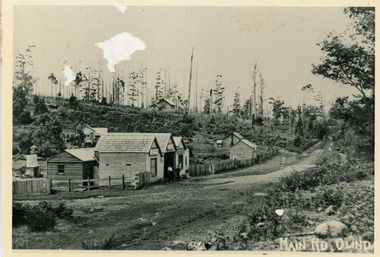
... store in foreground. Hodges blacksmith shop on roadside right. Coonara Road, then Mernda Road leads up out the picture right, Mt Dandenong Road goes down left. ...store in foreground. Hodges blacksmith shop on roadside right. Coonara Road, then Mernda Road leads up out the picture right, Mt Dandenong Road goes down left. ...c1908 view of Main Street Olinda with Dodd's store in foreground and Olinda State School up on the hill. Reverse of photograph has handwritten description by John Lundy-Clarke.Photo of Olinda taken about 1908 showing State School on skyline. Dodd’s store in foreground. Hodges blacksmith shop on roadside right. Coonara Road, then Mernda Road leads up out the picture right, Mt Dandenong Road goes down left. Range Road (the bullock track) is in immediate foreground and Sassafras turns to the right before the visible tracks on Mernda Road.olinda, jack dodd, general store, school -
 Mt Dandenong & District Historical Society Inc.
Photograph, The Mt Dandenong Road c1930, c1930
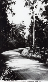
... Store and FiveWays, Kalorama. Copy of Rose Series postcard # 310. (2 copies) FiveWays Rose Series Mt Dandenong Road THE ROSE SERIES P. 310 THE MT DANDENONG ROAD VIC Black and white photograph showing a road passing through trees. ...Formed, unmade road. Possibly between Silvandale Store and FiveWays, Kalorama. Copy of Rose Series postcard # 310. (2 copies)Black and white photograph showing a road passing through trees. THE ROSE SERIES P. 310 THE MT DANDENONG ROAD VICfiveways, rose series, mt dandenong road -
 Mt Dandenong & District Historical Society Inc.
Photograph, Car On New Road Blocked By Tree
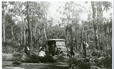
... Mt. Dandenong Tourist Road...Silvandale Store...Mt. Dandenong Tourist Road a short distance past present Silvandale Store (Kalorama Post Office now). ...Kalorama Mt. Dandenong Tourist Road Silvandale Store Site said to be the new Mt. ...Site said to be the new Mt. Dandenong Tourist Road a short distance past present Silvandale Store (Kalorama Post Office now). Early model vehicle and passengers delayed by tree across road. Not much progress being made with axe.kalorama, mt. dandenong tourist road, silvandale store -
 Mt Dandenong & District Historical Society Inc.
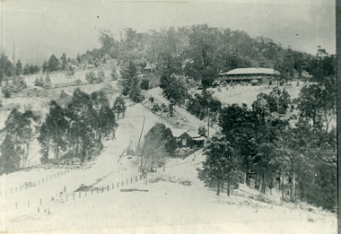
Photograph, The Gap Under Snow 1921, 1921
... New CRB road formation (unmetalled) comes into picture lower left corner, passes left of dray under the elms, then circles around behind the trees behind Miss Hands shop and home and Post Office (Mt Dandenong North) to pass out of picture left in centre of picture. It passes between Ted Prices Hay & Corn store and Walker’s house where the Estate Agency was later placed. ...Mt Dandenong North Snow The Gap under snow 1921. “Mountjoy” on hill. New CRB road formation (unmetalled) comes into picture lower left corner, passes left of dray under the elms, then circles around behind the trees behind Miss Hands shop and home and Post Office (Mt Dandenong North) to pass out of picture left in centre of picture. It passes between Ted Prices Hay & Corn store ...Snow scene looking up through The Gap (FiveWays) with Mountjoy Guest House on the hill to the right. The shop and post office are seen in the centre of the picture. This photograph has a detailed inscription on the back handwritten by John Lundy-Clarke in 1974.The Gap under snow 1921. “Mountjoy” on hill. New CRB road formation (unmetalled) comes into picture lower left corner, passes left of dray under the elms, then circles around behind the trees behind Miss Hands shop and home and Post Office (Mt Dandenong North) to pass out of picture left in centre of picture. It passes between Ted Prices Hay & Corn store and Walker’s house where the Estate Agency was later placed. Main Road then in centre of picture bend right behind Mountjoy. Price’s house and shop behind the blackwood left of road bend. CRB cuts across Barbers left of Elm trees.john lundy-clarke, kalorama, mountjoy, mountjoy, the gap, post office, mt dandenong north, snow
