
Showing 23 items matching "mt dandenong tourist road"
-
 Mt Dandenong & District Historical Society Inc.
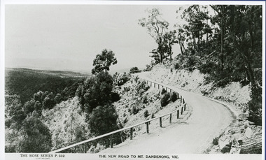
Photograph, The New Road to Mt. Dandenong Vic. c1935, c1935
... ...Mt. Dandenong Tourist Road...Enlarged for display from Rose postcard 'New Road' (Mt. Dandenong Tourist Road). Completed by 1930 but no bitumen as yet. ...Rose Series Postcard number 332 Kalorama Rose Series Mt. Dandenong Tourist Road c1935. Enlarged for display from Rose postcard 'New Road' (Mt. ...Rose Series Postcard number 332c1935. Enlarged for display from Rose postcard 'New Road' (Mt. Dandenong Tourist Road). Completed by 1930 but no bitumen as yet. Road not wider and rail along outer edge.kalorama, rose series, mt. dandenong tourist road -
 Mt Dandenong & District Historical Society Inc.
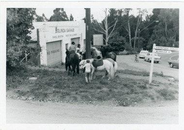
Photograph, Pony Club Outside Olinda Garage 1960s, c1960
... ...mt dandenong tourist road...Olinda garage on corner of Range Road and Mt Dandenong Tourist Road. Pony Club with 4 horses on grass. ralph Jones was garage owner at this time. ...Pony Club Olinda Garage garage Olinda Range Road mt dandenong tourist road Ralph Jones Olinda garage on corner of Range Road and Mt Dandenong Tourist Road. ...Olinda garage on corner of Range Road and Mt Dandenong Tourist Road. Pony Club with 4 horses on grass. ralph Jones was garage owner at this time. Dragster bike on road indicates early 1960s.pony club, olinda garage, garage, olinda, range road, mt dandenong tourist road, ralph jones -
 Mt Dandenong & District Historical Society Inc.
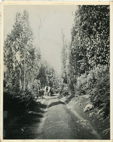
Photograph, Jeeves Coach on CRB Road at Foot of Farringdon Road Kalorama, 1920, 1920
... road...kalorama...mt dandenong north...mt dandenong tourist...Scene looking down Farringdon Road showing Jeeves horse drawn coach going along the CRB road (Mt Dandenong Tourist Road) in 1920. Detailed inscription on the back handwritten by John Lundy-Clarke in 1974....coach service jeeves crb road farringdon road kalorama mt dandenong north mt dandenong tourist road john lundy-clarke coach Jeeves Coach on CRB road at foot of Farringdon Road Kalorama (Mt Dandenong North) 1920. ...Scene looking down Farringdon Road showing Jeeves horse drawn coach going along the CRB road (Mt Dandenong Tourist Road) in 1920. Detailed inscription on the back handwritten by John Lundy-Clarke in 1974.Jeeves Coach on CRB road at foot of Farringdon Road Kalorama (Mt Dandenong North) 1920. Road was formed most of the length from Montrose by contractors Bladin and Dick employing Robert Logan the younger, in 1919 and lay unmetalled till metalled by the contractors in 1922. Mountain ash trees in foreground were on Thomas Hand’s original 23 acre holding. Those beyond coach were on Isaac Jeeves original 160 acre holding Selection Crown Allotment 925(B). This was the area forming part of the inheritance lost by John William Richardson because of the expense of his wife’s illness. Hand enlarged his 23 acres to 305 in 1874. William and his family grew large crops of raspberries on his area, part of which is in the foreground. It had been cleared by his father’s employees before 1877. The section below the Main Road was cultivated by Fred hand, son of William and grandson of Thomas in the twenties before he moved to Redcliffes where he is today (1974). Comment by John Lundy-Clarke 10.5.1974 coach service, jeeves, crb road, farringdon road, kalorama, mt dandenong north, mt dandenong tourist road, john lundy-clarke, coach -
 Mt Dandenong & District Historical Society Inc.
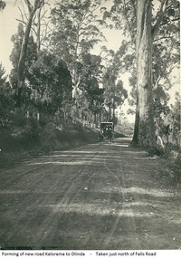
Photograph, Forming Of New Road Kalorama To Olinda, early 1920s
... ...mt dandenong tourist road...The new Main Road, now Mt Dandenong Tourist Road, was completed in 1926. This scene is looking towards Montrose down from the intesection of Falls Road....Wagon Road Main Road mt dandenong tourist road Falls Road Horse Scene of wagon drawn by two horses on wide dirt road with large trees on side of road. ...The new Main Road, now Mt Dandenong Tourist Road, was completed in 1926. This scene is looking towards Montrose down from the intesection of Falls Road.Scene of wagon drawn by two horses on wide dirt road with large trees on side of road. Taken just north of Falls Road.wagon, road, main road, mt dandenong tourist road, falls road, horse -
 Mt Dandenong & District Historical Society Inc.
Photograph, Car On New Road Blocked By Tree
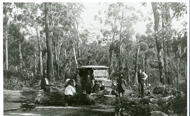
... ...Mt. Dandenong Tourist Road...Site said to be the new Mt. Dandenong Tourist Road a short distance past present Silvandale Store (Kalorama Post Office now). ...Kalorama Mt. Dandenong Tourist Road Silvandale Store Site said to be the new Mt. ...Site said to be the new Mt. Dandenong Tourist Road a short distance past present Silvandale Store (Kalorama Post Office now). Early model vehicle and passengers delayed by tree across road. Not much progress being made with axe.kalorama, mt. dandenong tourist road, silvandale store -
 Mt Dandenong & District Historical Society Inc.
Photograph, St. Michael and All Angels Anglican Church c1970, c1970
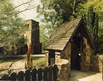
... ...mt. dandenong tourist road...St Michael and All Angels Anglican Church in the Parish of Mt Dandenong sited on the corner of Falls Road and the Mt Dandenong Tourist Road, Kalorama. ...falls road mt. dandenong tourist road st. michael's church st. michael and all angels anglican church anglican church henry l. speagle St Michael and All Angels Anglican Church in the Parish of Mt Dandenong sited on the corner of Falls Road and the Mt Dandenong Tourist Road, Kalorama. ...St Michael and All Angels Anglican Church in the Parish of Mt Dandenong sited on the corner of Falls Road and the Mt Dandenong Tourist Road, Kalorama. The church was built in 1940. For further information see 'A Light In The Hills', 2 editions by Henry L. Speagle.falls road, mt. dandenong tourist road, st. michael's church, st. michael and all angels anglican church, anglican church, henry l. speagle -
 Mt Dandenong & District Historical Society Inc.
Photograph
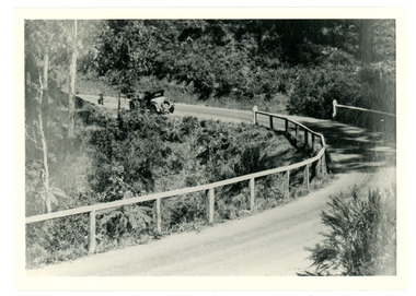
... ...mt dandenong tourist road...An old fashioned car can be seen pulling away from a bend on the new CRB Road at Wallaby Gully (now Mt Dandenong Tourist Road). Wallaby Gully is near the Mt Dandenong kindergarten. ...An old fashioned car can be seen pulling away from a bend on the new CRB Road at Wallaby Gully (now Mt Dandenong Tourist Road). Wallaby Gully is near the Mt Dandenong kindergarten. ...An old fashioned car can be seen pulling away from a bend on the new CRB Road at Wallaby Gully (now Mt Dandenong Tourist Road). Wallaby Gully is near the Mt Dandenong kindergarten. The year is c1926.Black and white photograph showing a car rounding a bend on a road surrounded by bush and fenced with a wooden rail fence.crb road, kindergarten, car, mt dandenong tourist road, wallaby gully -
 Mt Dandenong & District Historical Society Inc.
Photograph
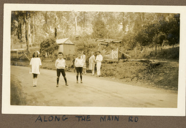
... ...Mt Dandenong Tourist Road...The road featured called the 'Main Road' is what we know know as Mt Dandenong Tourist Road. It has been made but not tarred. ...The road featured called the 'Main Road' is what we know know as Mt Dandenong Tourist Road. It has been made but not tarred. ...The photograph is from the album of Ivy Child. The road featured called the 'Main Road' is what we know know as Mt Dandenong Tourist Road. It has been made but not tarred. The identity of the people is unknown. Ivy May Child (1910 – 1989) was the daughter of Arthur Edward (Ted) Child (1878 – 1964) and Ethel May Madden (1888 – 1970). Ted Child was the son of Matthew Francis Child (1839 – 1933) and Martha Jeeves (1857 – 1926). He was the grandson of one of the early pioneers Francis Child. Ivy grew up on the family property on Childs Road and took many photographs. Most of these are glued into her photo album. The album covered the years from c1927 – 1932. Ivy married Henry William Burgess (1906 – 1968) in 1944. The photographs remain in their original state in the album with individual copies made. Sepia coloured photograph showing a stretch of road with two young boys and a girl standing in the middle. Behind them, standing on the edge of the road are two women and a man. Behind them is a wire and post fence with wooden gate and a shed. Bush is visible in the background.Handwritten below the photograph in the album: ALONG THE MAIN ROADivy child, main road, mt dandenong tourist road, tourist road, kalorama -
 Mt Dandenong & District Historical Society Inc.
Photograph
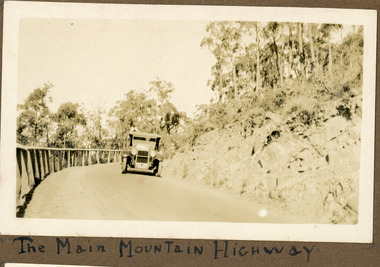
... CRB Road Mt Dandenong Tourist Road...The photograph shows an old car rounding a bend on what is now the Mt Dandenong Tourist Road. Around 1930 it would have been called the CRB Road or the Main Road. ...The photograph shows an old car rounding a bend on what is now the Mt Dandenong Tourist Road. Around 1930 it would have been called the CRB Road or the Main Road. ...The photograph shows an old car rounding a bend on what is now the Mt Dandenong Tourist Road. Around 1930 it would have been called the CRB Road or the Main Road. The photograph is in the Ivy Child Album. Ivy May Child (1910 – 1989) was the daughter of Arthur Edward (Ted) Child (1878 – 1964) and Ethel May Madden (1888 – 1970). Ted Child was the son of Matthew Francis Child (1839 – 1933) and Martha Jeeves (1857 – 1926). He was the grandson of one of the early pioneers Francis Child. Ivy grew up on the family property on Childs Road and took many photographs. Most of these are glued into her photo album. The album covered the years from c1927 – 1932. Ivy married Henry William Burgess (1906 – 1968) in 1944.Sepia coloured photograph showing an old car rounding a bend in the road.Below photograph in album: The Main Mountain Highwaymain road, crb road mt dandenong tourist road, car, automobile, ivy child, kalorama -
 Mt Dandenong & District Historical Society Inc.
Photograph
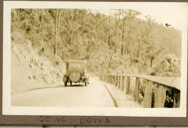
... ...Mt Dandenong Tourist Road...Now named the Mt Dandenong Tourist Road. The photograph is glued in the Ivy Child Album. ...Now named the Mt Dandenong Tourist Road. The photograph is glued in the Ivy Child Album. ...The photograph is a pair to a similar photograph taken from the front view. The car is travelling down the CRB or Main Road at Kalorama c1930. Now named the Mt Dandenong Tourist Road. The photograph is glued in the Ivy Child Album. Ivy May Child (1910 – 1989) was the daughter of Arthur Edward (Ted) Child (1878 – 1964) and Ethel May Madden (1888 – 1970). Ted Child was the son of Matthew Francis Child (1839 – 1933) and Martha Jeeves (1857 – 1926). He was the grandson of one of the early pioneers Francis Child. Ivy grew up on the family property on Childs Road and took many photographs. Most of these are glued into her photo album. The album covered the years from c1927 – 1932. Ivy married Henry William Burgess (1906 – 1968) in 1944. The photographs remain in their original state in the album with individual copies made. Sepia coloured photograph showing an old car travelling down a road bordered by a rail fence.Written below the photograph in album: Going Downcar, automobile, ivy child, crb road, main road, mt dandenong tourist road -
 Mt Dandenong & District Historical Society Inc.
Photograph
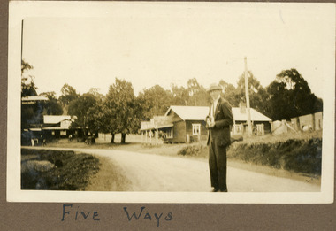
... ...Mt Dandenong Tourist Road...The man in the photograph is standing on the new CRB or Main Road (now Mt Dandenong Tourist Road). The date would be late 1920s. ...The man in the photograph is standing on the new CRB or Main Road (now Mt Dandenong Tourist Road). The date would be late 1920s. ...The man in the photograph is standing on the new CRB or Main Road (now Mt Dandenong Tourist Road). The date would be late 1920s. The building directly behind the man is a General Store that became a bank and is now a gallery. The FiveWays cafe is on the LHS of the photograph with the Mountjoy Guesthouse behind it up on the hill. The two elm trees that marked the Jeeves property are visible in the centre of the photograph. The image is from the album of Ivy Child. Ivy May Child (1910 – 1989) was the daughter of Arthur Edward (Ted) Child (1878 – 1964) and Ethel May Madden (1888 – 1970). Ted Child was the son of Matthew Francis Child (1839 – 1933) and Martha Jeeves (1857 – 1926). He was the grandson of one of the early pioneers Francis Child. Ivy grew up on the family property on Childs Road and took many photographs. Most of these are glued into her photo album. The album covered the years from c1927 – 1932. Ivy married Henry William Burgess (1906 – 1968) in 1944. The photographs remain in their original state in the album with individual copies made. Sepia coloured photograph showing a man in a suit and hat standing in the foreground of an intersection with a building either side.Below photograph in album: FIVE WAYSfive ways, fiveways, fiveways cafe, mountjoy, kalorama, crb road, main road, mt dandenong tourist road, bank, elm trees, jeeves -
 Mt Dandenong & District Historical Society Inc.
Photograph, Farringdon Road
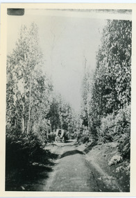
... Mt Dandenong Road...CRB Road...Farringdon Road...Jeeves...Ellis Jeeves...coach...Mt Dandenong Tourist...Road. John Lundy-Clarke grew up in the Kalorama/Mt Dandenong area and later in life (1972-74) began to write a comprehensive history of the area working from an original settlement map in an effort to cover all areas. Mt Dandenong Road CRB Road Farringdon Road Jeeves Ellis Jeeves coach Mt Dandenong Tourist ...Mt Dandenong Road (CRB Road, New Road, Main Road) was begun in the early 1920s and completed c1926. This would be a very early photograph in the history of the road and shows a Jeeves coach travelling along the new road at the base of Farringdon Road in Kalorama. Ellis Jeeves established the coach sevice between Kalorama and Croydon in 1904. It originally travelled down the Old Coach Road. John Lundy-Clarke grew up in the Kalorama/Mt Dandenong area and later in life (1972-74) began to write a comprehensive history of the area working from an original settlement map in an effort to cover all areas.Black and white photograph looking down an unmade road showing a coach travelling along another unmade road at the bottom. Roads are tree lined. handwritten inscription on reverse by John Lundy-Clarke.1920 Farringdon Road, looking at Jeeves Coach on Mt Dandenong Road.mt dandenong road, crb road, farringdon road, jeeves, ellis jeeves, coach, mt dandenong tourist road, kalorama -
 Mt Dandenong & District Historical Society Inc.
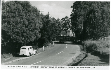
Photograph, Mountain Highway Near St. Michael's Church, Mt. Dandenong, Vic, c1950
... ...Mt. Dandenong Tourist Road...The correct name is the Mount Dandenong Tourist Road at Mt. Dandenong / Kalorama as Falls Road is the boundary. ...Michael's Church Mt. Dandenong Tourist Road Copy of Rose Series post card taken c1950. ...Rose Series Postcard number 2415Copy of Rose Series post card taken c1950. St. Michael's Foundation Stone laid in 1940. Name 'Mountain Highway" is incorrect as the Mountain Highway was the Sassafras - Basin Road though it may not have received that name by 1950. The correct name is the Mount Dandenong Tourist Road at Mt. Dandenong / Kalorama as Falls Road is the boundary. Note: Heavy roadside vegetation, no white lines at side of road. White car probably pre war Vauxhall.kalorama, mount dandenong, rose series, st. michael's church, mt. dandenong tourist road -
 Ballarat Heritage Services
Programme - Program, Wine Women and Song!, c1999
... Programme MONTROSE TOWN CENTRE Mt Dandenong Tourist Road, Montrose SHIRE of YARRA RANGES...Programme MONTROSE TOWN CENTRE Mt Dandenong Tourist Road, Montrose SHIRE of YARRA RANGES Black ink on cream card booklet Wine Women and Song! ...Black ink on cream card bookletMONTROSE TOWN CENTRE Wine, Women and Song! Programme MONTROSE TOWN CENTRE Mt Dandenong Tourist Road, Montrose SHIRE of YARRA RANGESjacqueline dark, jacqui dark, wine, women and song, music, yarra ranges, montrose -
 Mt Dandenong & District Historical Society Inc.
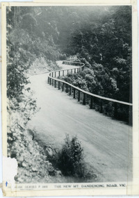
Photograph, The New Mt Dandenong Road, Vic
... Copy of Rose Series postcard #385 showing the new Mt Dandenong Tourist Road with wooden railing fence on low side of road. ...mt dandenong road rose series windy bend landslide View downhill from the Windy Bend showing the site of the 1972 landslide. In this picture the road is running along the top edge of the wall 900’ thick of Kalorama Docite that plunges thousands of feet deep down into the earth below the Ranges and extends to Fern Tree Gully. It was once a horizontal terrace nearly ten miles square and tipped over to the left when the mountain subsided into its volcanic cauldron. Copy of Rose Series postcard #385 showing the new Mt Dandenong Tourist ...Copy of Rose Series postcard #385 showing the new Mt Dandenong Tourist Road with wooden railing fence on low side of road. Surface not yet made. This photograph has a detailed inscription on the back handwritten by John Lundy-Clarke in 1974.View downhill from the Windy Bend showing the site of the 1972 landslide. In this picture the road is running along the top edge of the wall 900’ thick of Kalorama Docite that plunges thousands of feet deep down into the earth below the Ranges and extends to Fern Tree Gully. It was once a horizontal terrace nearly ten miles square and tipped over to the left when the mountain subsided into its volcanic cauldron.mt dandenong road, rose series, windy bend, landslide -
 Mt Dandenong & District Historical Society Inc.
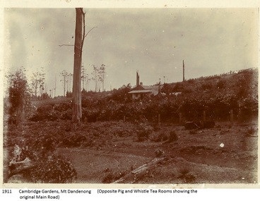
Photograph, Cambridge Gardens Mt Dandenong
... Mt Dandenong in 1898. He secured a property known as Cambridge Gardens which was located between the present Mt Dandenong Tourist Road and Yarrabee Road. ...Mt Dandenong in 1898. He secured a property known as Cambridge Gardens which was located between the present Mt Dandenong Tourist Road and Yarrabee Road. ...William Dower took up 10 acres at Mt Dandenong in 1898. He secured a property known as Cambridge Gardens which was located between the present Mt Dandenong Tourist Road and Yarrabee Road. William and his wife Elizabeth had seven sons (Will, Harry, Bert, Walter, Joe, Edgar and Robert) and four daughters (Emmy, May, Ada and Ruby). There was a two room slab hut on the property when they took possession and they added another five rooms using trees from the property. The Pig and Whistle Tea Rooms referred to in the inscription is now Tatra Hut. Sepia coloured photograph (copy of an original) showing a cottage in the centre of a cleared area with a fence at the front and a significant dead tree left of centre. There is an inscription typed below the photograph.1911 Cambridge gardens, Mt Dandenong (Opposite Pig and Whistle Tea Rooms showing the original Main Road)dower, william dower, elizabeth dower, will dower, harry dower, bert dower, walter dower, joe dower, edgar dower, robert dower, emmy dower, ada dower, ruby dower, may dower, tatra hut, pig and whistle, cambridge gardens, yarrabee road -
 Mt Dandenong & District Historical Society Inc.
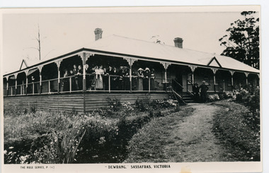
Photograph, Dewrang, c1913
... Dewrang Guest House is situated at the corner of The Crescent and the Mt Dandenong Tourist Road at Sassafras. It belonged to the Green family who owned the garage and coach service which operated from the site of the current Sassafras Tavern. ...Dewrang Guest House is situated at the corner of The Crescent and the Mt Dandenong Tourist Road at Sassafras. It belonged to the Green family who owned the garage and coach service which operated from the site of the current Sassafras Tavern. ...Dewrang Guest House is situated at the corner of The Crescent and the Mt Dandenong Tourist Road at Sassafras. It belonged to the Green family who owned the garage and coach service which operated from the site of the current Sassafras Tavern. Dewrang burned down in 1931. The Argus July 27 1931 FIRE AT SASSAFRAS. Guest House Burnt. SASSAFRAS - Sunday ‘Dewrang’ one of the oldest guest houses in the town was, with its contents, burnt yesterday. The property was owned by Mr J Green, of Kallista, and was occupied by Mr R Gros. Mr Gros and family lost all their belongings. The building was insured for £3,500 and the contents for approximately £1,200 B & W Rose Series postcard showing a close up front view of Dewrang Guest House with a group of adults crowded together on the front verandah.The Rose Series P. 143 "DEWRANG" SASSAFRAS, VICTORIAdewrang, guest house, j green, r gros, sassafras -
 Kiewa Valley Historical Society
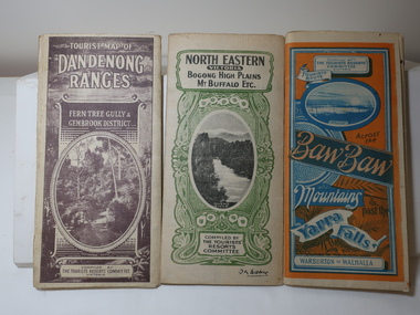
Maps - Tourist
... Tourist map of the Dandenong Ranges. Brown cover. dated 6-4-33. Govt. printer showing roads, tracks in red and heights of the land. 2. Tourist Map of Warburton, Mt...Mt Beauty and Bogong are not shown. The description of the Snow Lines was important as skiers, bushwalkers and campers relied on them. The details on the map include "ADB. Numbered from A.1-377 round plates. CD Numbered from C 1-235 square plates. Poles about 3 chains apart 27 to the mile." 1933 Maps Tourism Maps Bogong High Plains Map 1933 snow poles By Authority of H.J. Green - 6 pence. Dept of Lands and Survey, Melbourne 3 Tourist location maps (folded) and printed on parchment. 1. Tourist map of the Dandenong Ranges. Brown cover. dated 6-4-33. Govt. printer showing roads ...These maps were all dated 1933 which was before the construction of the Kiewa Hydro Electric Scheme and when Tawonga was spelt Towonga. North East Victoria in 1933 was before the construction of the Kiewa Hydro Electric Scheme so the townships of Mt Beauty and Bogong are not shown. The description of the Snow Lines was important as skiers, bushwalkers and campers relied on them. The details on the map include "ADB. Numbered from A.1-377 round plates. CD Numbered from C 1-235 square plates. Poles about 3 chains apart 27 to the mile." 3 Tourist location maps (folded) and printed on parchment. 1. Tourist map of the Dandenong Ranges. Brown cover. dated 6-4-33. Govt. printer showing roads, tracks in red and heights of the land. 2. Tourist Map of Warburton, Mt Baw Baw, and Walhalla. Blue and Orange cover. dated 23-5-33 Govt. printer. 3 different maps of each area showin roads, tracks and timber tramways.Also in red and blue. 3. Tourist Map of North Eastern Victoria including Bogong High Plains Mt Buffalo Etc. Green cover. dated June 1933 Govt. printer. Main map and insert titled Bogong High Plains. Showing roads , tracks and tram ways. On insert showing snow poles. Also Red and Blue and mountains.By Authority of H.J. Green - 6 pence. Dept of Lands and Survey, Melbourne1933 maps, tourism maps, bogong high plains map 1933, snow poles -
 Mt Dandenong & District Historical Society Inc.
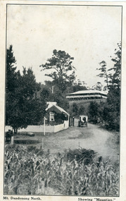
Photograph, Mt Dandenong North. Showing "Mountjoy"
... tourist destination, the coach yards making it a centre of the district. ‘Mountjoy’ is a central feature of many photographs of Kalorama in the 1900s. The building burned down in 1975. Mt. Dandenong North was renamed Kalorama in 1926. postcard mountjoy guest house beulah tea room beulah mt dandenong north kalorama On front ; Mt. Dandenong North. Showing "Mountjoy." Black and white postcard showing a horse and cart on road ...The building with the white picket fence is the Beulah Tea Gardens opened by Eliza Hand c1904 at The Gap (now FiveWays). The building is still operating as a cafe. The Tourist Road does not yet exist. Old Coach Road comes into the picture from the right and the horse and cart is heading up Ridge Road. The elm trees can be seen on the left. The building up on the hill is the Mountjoy Guest House. ‘Mountjoy’ was built by the Paynter family in 1905. It had fourteen bedrooms, a dining room and sitting room, kitchen with a big wood burning range and verandahs on three sides. There were commanding views of the eastern ranges and the city to the west. Ellis Jeeves purchased ‘Mountjoy’ in 1908 and it soon became a popular tourist destination, the coach yards making it a centre of the district. ‘Mountjoy’ is a central feature of many photographs of Kalorama in the 1900s. The building burned down in 1975. Mt. Dandenong North was renamed Kalorama in 1926.Black and white postcard showing a horse and cart on road between two buildings.On front ; Mt. Dandenong North. Showing "Mountjoy."postcard, mountjoy, guest house, beulah tea room, beulah, mt dandenong north, kalorama -
 Mt Dandenong & District Historical Society Inc.
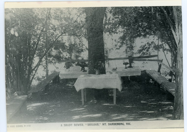
Photograph, Tea Tables at "Shiloah"
... tourist attraction but the making of the Olinda Creek Road destroyed the fern gullies and, by the 1930s, it was all finished. This photograph shows the tea tables at 'Shiloah' where Selina Jeeves and her daughter Elsie served afternoon tea to visitors. shiloah isaac jeeves the younger guest house afternoon tea ferns Selina Jeeves Elsie Jeeves On front - Rose Series P. 170 A SHADY BOWER "SHILOAH" MT DANDENONG. ...Originally the home of Isaac Jeeves, brother of Ellis Jeeves, ‘Shiloah’ was enlarged to take guests in the early 1900s. It was situated close to a beautiful fern gully and Isaac and his family capitalised on this by setting out walking tracks through the ferns. They charged 1/- to walk through and this included afternoon tea in a garden setting. ‘Shiloah’ was a popular tourist attraction but the making of the Olinda Creek Road destroyed the fern gullies and, by the 1930s, it was all finished. This photograph shows the tea tables at 'Shiloah' where Selina Jeeves and her daughter Elsie served afternoon tea to visitors.Black and white photograph taken from a Rose Series postcard showing tables set up in an exterior courtyard with bench seating.On front - Rose Series P. 170 A SHADY BOWER "SHILOAH" MT DANDENONG. VIC.shiloah, isaac jeeves the younger, guest house, afternoon tea, ferns, selina jeeves, elsie jeeves -
 Mt Dandenong & District Historical Society Inc.
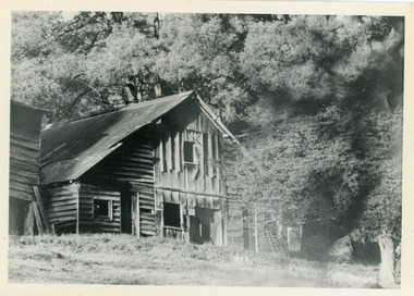
Photograph, Isaac Jeeves' Barn
... ‘Shiloah’ was a popular tourist attraction but the making of the Olinda Creek Road destroyed the fern gullies and, by the 1930s, it was all finished. John Lundy-Clarke grew up in the Kalorama/Mt Dandenong area and later in life (1972-74) began to write a comprehensive history of the area working from an original settlement map in an effort to cover all areas....‘Shiloah’ was a popular tourist attraction but the making of the Olinda Creek Road destroyed the fern gullies and, by the 1930s, it was all finished. John Lundy-Clarke grew up in the Kalorama/Mt Dandenong area and later in life (1972-74) began to write a comprehensive history of the area working from an original settlement map in an effort to cover all areas. ...Large barn built c1886 by Isaac Jeeves the younger on his property where the homestead 'Shiloah' stood. The barn was reputedly made from timbers split from only one messmate tree. Originally the home of Isaac Jeeves, brother of Ellis Jeeves, ‘Shiloah’ was enlarged to take guests in the early 1900s. It was situated close to a beautiful fern gully and Isaac and his family capitalised on this by setting out walking tracks through the ferns. They charged 1/- to walk through and this included afternoon tea in a garden setting. ‘Shiloah’ was a popular tourist attraction but the making of the Olinda Creek Road destroyed the fern gullies and, by the 1930s, it was all finished. John Lundy-Clarke grew up in the Kalorama/Mt Dandenong area and later in life (1972-74) began to write a comprehensive history of the area working from an original settlement map in an effort to cover all areas.Black and white photograph showing a large wooden structure surrounded by trees. Handwritten inscription on reverse by John Lundy-Clarke.Home of Isaac Jeeves the younger. Built about 1886 of timbers split from one messmate tree. Photo 1973isaac jeeves the younger, barn, kalorama, shiloah, messmate -
 Mt Dandenong & District Historical Society Inc.
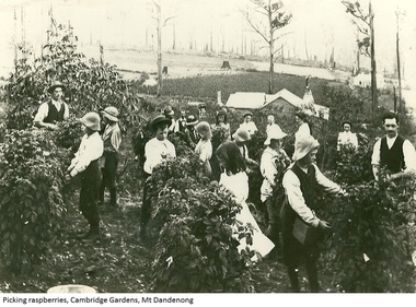
Photograph, Picking Raspberries Cambridge Gardens, Mt Dandenong, c1905
... Dandenongs in 1898, taking up 10 acres. His property was Cambridge Gardens located between the present Mt Dandenng Tourist Road and Yarrabee Road. ...Dandenongs in 1898, taking up 10 acres. His property was Cambridge Gardens located between the present Mt Dandenng Tourist Road and Yarrabee Road. ...William Dower brought his family to the Dandenongs in 1898, taking up 10 acres. His property was Cambridge Gardens located between the present Mt Dandenng Tourist Road and Yarrabee Road. William and his wife Elizabeth had seven boys (Will, Harry, Bert, Walter, Joe, Edgar, Robert) and four girls (Emmy, may, Ada and Ruby). This photograph shows raspberry picking at Cambridge Gardens c1907. The Dower Homestead is visible. The boys in the floppy felt hats are from Burwood Boys Home. Ruby Dower is centre front. Will Dower right of picture and Walter Dower left of picture.Ada, Carrie, Elizabeth, May and Emmy are also in the photo.Black and white photograph showing raspberry pickers at the Dower property Cambridge Gardens at Mt Dandenong. Printed from an image supplied on a CD.dower, william dower, ruby dower, raspberry, raspberry crop, cambridge gardens, walter dower, mt dandenong -
 Mt Dandenong & District Historical Society Inc.
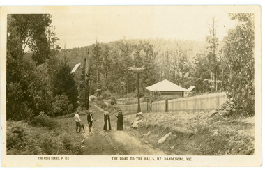
Photograph, The Road To The Falls Mt. Dandenong. Vic, early 1900s
... Road Olinda Falls mt dandenong Rose Series On front of postcard: THE ROSE SERIES #152 THE ROAD TO THE FALLS, MT. DANDENONG. VIC. On back of postcard: Mr J Woolrich 58 Mountfield St Brunswick Wishing you many happy returns of the day from Auntie Florrie. Postcard showing two men and two women standing on Falls Road and two girls sitting on the grassy bank. This section of Falls Road would be below the current Tourist ...Postcard showing two men and two women standing on Falls Road and two girls sitting on the grassy bank. This section of Falls Road would be below the current Tourist Road. A long fence has been built on the LHS and a house with a verandah is clearly seen. Early 1900s. The postcard appears to have been sent to Jim Woolrich from Auntie Florrie.On front of postcard: THE ROSE SERIES #152 THE ROAD TO THE FALLS, MT. DANDENONG. VIC. On back of postcard: Mr J Woolrich 58 Mountfield St Brunswick Wishing you many happy returns of the day from Auntie Florrie. falls road, olinda falls, mt dandenong, rose series
