Showing 7 items matching "mt eccles"
-
 Federation University Art Collection
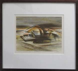
Work on paper - Artwork - Printmaking, Jack, Kenneth, 'Mt Eccles and Crater Lake, No.3 Volcanic Plains of Victoria ' by Kenneth Kack, 1961
... 'Mt Eccles and Crater Lake, No.3 Volcanic Plains of Victoria ' by Kenneth Kack......mt eccles...Donated through the Australian Gifts Programme by Katherine Littlewood. 'Mt Eccles and Crater Lake, No.3 Volcanic Plains of Victoria ' by Kenneth Kack Work on paper Artwork - Printmaking Jack, Kenneth ...Framed four plate lithograph depicitng Nt Eccles and Crater Lake on the Victorian cvolcanic plains. Donated through the Australian Gifts Programme by Katherine Littlewood.Edition 23/42kenneth jack, printmaking, mt eccles, volcano, lithograph -
 Victorian Aboriginal Corporation for Languages
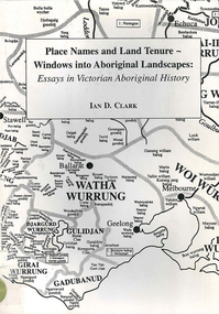
Book, Ian D Clark, Place names and land tenure : windows into Aboriginal landscapes : essays in Victorian Aboriginal history, 1998
... ...Mt Eccles...Victorian Aboriginal Corporation for Languages 33 Saxon Street Brunswick melbourne Djab Wurrung Ngengen Wurrung Koroitgundidj Dhauwurud Wurrung Djab Wurrung Barababaraba Daung Wurrung Taungurung Dja Dja Wurrung Jardwadjali Jodajoda Yorta Yorta Nguri-illam Wurrung Waywurru Koroit Buangor Mt Eccles Mt Napier Langi Ghiran Grampians National Park massacres clan organization land tenure George Augustus Robinson Samuel Carter Aldo Massola Alfred William Howitt maps, document reproductions This work is a collection of twelve essays that are concerned with place names, clan organisation and local and regional Aboriginal history. ...This work is a collection of twelve essays that are concerned with place names, clan organisation and local and regional Aboriginal history.maps, document reproductionsdjab wurrung, ngengen wurrung, koroitgundidj, dhauwurud wurrung, djab wurrung, barababaraba, daung wurrung, taungurung, dja dja wurrung, jardwadjali, jodajoda, yorta yorta, nguri-illam wurrung, waywurru, koroit, buangor, mt eccles, mt napier, langi ghiran, grampians national park, massacres, clan organization, land tenure, george augustus robinson, samuel carter, aldo massola, alfred william howitt -
 Ballarat Heritage Services
Document, Helen Doyle & Context Pty Ltd, Moyne Heritage Study Stage 2 Vol 2, 2006
... ...Mt Eccles...Ballarat Heritage Services PO Box 2209 Bakery Hill Post Office goldfields Moyne Minhamite Port Fairy Mt Shadwell Mt Rouse Mt Napier Mt Eccles Tower Hill Dhauwurdwurrung Djabwurrung Giraiwurrung Caramut James Atkinson Special Survey William Rutledge Yangery Land selection act closer settlement soldier settlement Framlingham lime burning Atkinson’s Belfast Survey Belfast Killarney Crossley Aboriginal Protectorate Lake COndah Hexham Hexham Common School Koroit convent hurling mile posts Kirkstall Ballyhurst Dundonnell Curdievale Ballangeich Hawkesdale Irish Scottish Aborigines Tower Hill Cemetery St Brigid’s Catholic Church 141 page heritage study Moyne Heritage Study Stage 2 Vol 2 Document Helen Doyle & Context Pty Ltd ...141 page heritage studymoyne, minhamite, port fairy, mt shadwell, mt rouse, mt napier, mt eccles, tower hill, dhauwurdwurrung, djabwurrung, giraiwurrung, caramut, james atkinson, special survey, william rutledge, yangery, land selection act, closer settlement, soldier settlement, framlingham, lime burning, atkinson’s belfast survey, belfast, killarney, crossley, aboriginal protectorate, lake condah, hexham, hexham common school, koroit convent, hurling, mile posts, kirkstall, ballyhurst, dundonnell, curdievale, ballangeich, hawkesdale, irish, scottish, aborigines, tower hill cemetery, st brigid’s catholic church -
Glenelg Shire Council Cultural Collection
Book, People of the Lake - the story of Lake Condah Mission, n.d
... Many Aboriginal people refused to move from their ancestral land and eventually the government agreed to build a mission at Lake Condah, close to some of the eel traps and within sight of Budj Bim (Mt Eccles). The mission opened in 1867. The Mission was formally closed in 1918, and Aboriginal people were forced off the Mission, some moving to Lake Tyers. ...Aboriginal history Gunditjmara Lake Condah mission history Budj Bim 27,000 years ago molten lava pouring from the eruption of Budjbim (Mt. Eccles) formed Lake Condah and the unique landscape that surrounds it. ...27,000 years ago molten lava pouring from the eruption of Budjbim (Mt. Eccles) formed Lake Condah and the unique landscape that surrounds it. Over time this area known as "The Stony Rises" or "The Stones" became an important geological area for Koories and, later, Europeans.12 page A4 size booklet, cream with brown print.27,000 years ago molten lava pouring from the eruption of Budjbim (Mt. Eccles) formed Lake Condah and the unique landscape that surrounds it. Over time this area known as "The Stony Rises" or "The Stones" became an important geological area for Koories and, later, Europeans.aboriginal history, gunditjmara, lake condah, mission history, budj bim -
 Ballarat Heritage Services
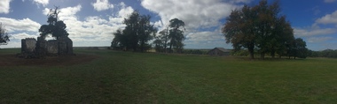
Photograph - Photograph - Colour, Former Lake Condah Aboriginal Mission, 17/04/2016
... Many Aboriginal people refused to move from their ancestral land and eventually the government agreed to build a mission at Lake Condah, close to some of the eel traps and within sight of Budj Bim (Mt Eccles). The mission opened in 1867. The Mission was formally closed in 1918, and Aboriginal people were forced off the Mission, some moving to Lake Tyers. ...Many Aboriginal people refused to move from their ancestral land and eventually the government agreed to build a mission at Lake Condah, close to some of the eel traps and within sight of Budj Bim (Mt Eccles). The mission opened in 1867. The Mission was formally closed in 1918, and Aboriginal people were forced off the Mission, some moving to Lake Tyers. ...The Lake Condah Mission site includes bluestone ruins and a reconstructed timber building, as well as the cemetery which were part of the original settlement. With European settlement in the 1830s came conflict. Gunditjmara people fought for their land during the Eumerella wars, which lasted more than 20 years. As this conflict drew to an end in the 1860s, many Aboriginal people were displaced and the Victorian government began to develop reserves to house them. Many Aboriginal people refused to move from their ancestral land and eventually the government agreed to build a mission at Lake Condah, close to some of the eel traps and within sight of Budj Bim (Mt Eccles). The mission opened in 1867. The Mission was formally closed in 1918, and Aboriginal people were forced off the Mission, some moving to Lake Tyers. The Gunditjmara protested against the Mission’s closure and many continued to reside in the buildings until the majority of the reserve land was handed over to the Soldier Settlement Scheme in the 1940s. The mission was destroyed by the government in the 1950s in an effort to force the integration of Gunditjmara people with the general community but the Gunditjmara people continued to live in the area and protect their heritage. The mission lands were returned to the Gunditjmara in 1987. Lake Condah Mission is a place with special meaning to the Gunditjmara community - as a community meeting place, an administrative centre, a symbol of political struggle and a link to family histories. As a result the Gunditjmara community do not want open public access to this site. Key Features of Interest Ruins of stone cottages and plot remains of buildings such as the church Reconstructed dormitory building (https://www.budjbim.com.au/visit/cultural-sites/lake-condah-mission/?gclid=EAIaIQobChMIz6j36ZvF-QIV8ZhmAh2tmA3qEAAYASAAEgLxrvD_BwE, accessed 2022)Colour photographs of the former Lake Condah Aboriginal Missionlake condah, lake condah aboriginal mission, aborigines, aboriginal, gunditjmara, eumerella wars -
Glenelg Shire Council Cultural Collection
Map - Map - RACV Road Map, 1970s
... Large coloured map of Portland District, small maps of Portland, Mt Gambier, Hamilton, Mount Eccles National Park, Coonawarra Wineries. ...Large coloured map of Portland District, small maps of Portland, Mt Gambier, Hamilton, Mount Eccles National Park, Coonawarra Wineries. ...RACV road map, Portland district, Port MacDonnell to Warrnambool. Large coloured map of Portland District, small maps of Portland, Mt Gambier, Hamilton, Mount Eccles National Park, Coonawarra Wineries. When folded, black and white phot of child fishing on jetty on Moyne River, Port Fairy on coverroad touring, racv, map -
Federation University Historical Collection
Report, Concept and Market Study for the Development of a Time Tunnel in Hamilton
... Mt Helen Campus Federation University Australia E.J. Barker Library (top floor) Mount Helen goldfields victorian tourisim industry tourism hamilton time tunnel population agricultural history ansett aviation reginald hamilton aboriginal mount eccles dhauwurd wurrung gundidjmara lake condah lutheran german tarrington tetrapods Report compiled by six students of Tourism at University of Ballarat (later Federation University Australia) Concept and Market Study for the Development of a Time Tunnel in Hamilton Report Heather Clapman Amanda Lockey Sallie Ridgeway Emma Condon Ben Matthews Catherine Scott ...Report compiled by six students of Tourism at University of Ballarat (later Federation University Australia)victorian tourisim industry, tourism, hamilton, time tunnel, population, agricultural history, ansett, aviation, reginald hamilton, aboriginal, mount eccles, dhauwurd wurrung, gundidjmara, lake condah, lutheran, german, tarrington, tetrapods