Federation University Historical Collection
Map, Geological Map of Learmonth, 1882, 10/1882
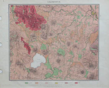
... ...mt pisgah...Barker Library (top floor) Mount Helen goldfields learmonth lake learmonth glendaruel burrumbeet mt blowhard morton's hill mt bolan addington mt cavern coghill's hill mt hollowback mt pisgah weatherboard hill webster's hill foster's hill mt bolen one mile hill vaughan's hill tourello stattion ballarat to maryborough railway saddleback hill ceres brown's hill ross's hill norman taylor robert burrows richard shephard james finnie Two copies: (printed noted attached)
3.) ...
Two copies: (printed noted attached)
3.) Rectangular geological map edged in masking tape. Six colours define geology and are predominantly pink.
Scale 40 chains to one inch
.4) Notes referring to the Geological Map of Learmonth learmonth, lake learmonth, glendaruel, burrumbeet, mt blowhard, morton's hill, mt bolan, addington, mt cavern, coghill's hill, mt hollowback, mt pisgah, weatherboard hill, webster's hill, foster's hill, mt bolen, one mile hill, vaughan's hill, tourello stattion, ballarat to maryborough railway, saddleback hill, ceres, brown's hill, ross's hill, norman taylor, robert burrows, richard shephard, james finnie