Showing 14 items matching "mt sugarloaf"
-
 Kew Historical Society Inc
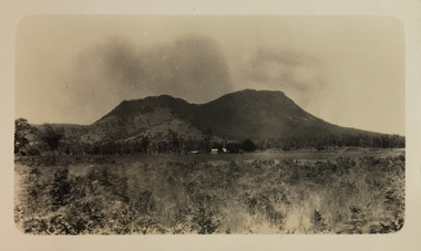
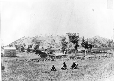
Photograph - Cathedral Range and Mt Sugarloaf, c.1926
... Cathedral Range and Mt Sugarloaf......mt sugarloaf...The photograph shows the Cathedral Range on the Buxton Marysville Road in the distance.The high peak on the right is Mt Sugarloaf. ...The photograph shows the Cathedral Range on the Buxton Marysville Road in the distance.The high peak on the right is Mt Sugarloaf. Photograph Cathedral Range and Mt Sugarloaf ...Henry Beater Christian (1886-1962) , was a descendant of one of the earliest settler families in Kew. Employed at the Kew Asylum as a 'public servant', he was a skilled amateur photographer, photographing numerous scenes in Kew and on his travels around Victoria. The majority of his photographs date from 1916 to 1929. His finest photographs are housed in two photograph albums. Digital copy of a photograph from page 18 of the 47-page photograph album containing 261 gelatinous silver images, loaned by Diane Washfold with permission given to digitise and hold a copy in our collection. This photograph, dating from c.1926, forms part of a group of photos taken on a bushwalking trip to Marysville, Victoria. John Chapman has written in 'Bushwalking Clubs - A Brief History', about the establishment in Victoria of the first bushwalking club in 1888, and the popularisation of bushwalking during the interwar period. The photograph shows the Cathedral Range on the Buxton Marysville Road in the distance.The high peak on the right is Mt Sugarloaf. "Spur" [illegible ink inscription]henry beater christian (1886-1962), landscape photography, kew (vic.) — yarra river, christian-washfold collection, photograph albums, bushwalking -- victoria, cathedral range, mt sugarloaf -
 Bendigo Historical Society Inc.
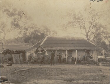
Photograph - FARMHOUSE NEAR MT SUGARLOAF - SLAB HUT, c.1880
... FARMHOUSE NEAR MT SUGARLOAF - SLAB HUT...An important photo of early settlers showing type and construction of farmhouse, type of farm implements and clothing Photograph FARMHOUSE NEAR MT SUGARLOAF - SLAB HUT ...Sepia photograph. Slab hut with bark roof, verandah. One brick chimney, weatherboard skillion at L end. One male under verandah. One male in yard. One male mounted on horse. Barrels, wheelbarrow, four wheeled horse drawn vehicle under or near verandah. Inscriptions on front 'MP94', in red ballpoint ink '28'.On Back in grey lead 'Axedale family near Sugarloaf'.( near Fosterville ) On back in red ball point pen '28'. History of object: Previous Acc. No. 'MP 94'. An important photo of early settlers showing type and construction of farmhouse, type of farm implements and clothingBendigo Advertiserbuildings, residential, cottage -
 Lakes Entrance Historical Society
Map - State Aerial Survey Victoria, Bruthen A Zone 7, A C Brooks Gov. Printer
... Shows aerial view of Nicholson River, Mt Sugarloaf, Mt. Welcome, Mt Hoad, Roads and Creeks....Lakes Entrance Historical Society 4 Marine Parade Lakes Entrance gippsland Roads Waterways Mountains Shows aerial view of Nicholson River, Mt Sugarloaf, Mt. Welcome, Mt Hoad, Roads and Creeks. ...Shows aerial view of Nicholson River, Mt Sugarloaf, Mt. Welcome, Mt Hoad, Roads and Creeks.roads, waterways, mountains -
Lakes Entrance Historical Society
Map - Topographical Map Bruthen 844
... Shows townships from Nungatta to Kaegreut Timbarra, The Ash Range, Mt Sugarloaf, Colquhoun North, Tambo River...Lakes Entrance Historical Society 4 Marine Parade Lakes Entrance gippsland Waterways Roads Mountains Shows townships from Nungatta to Kaegreut Timbarra, The Ash Range, Mt Sugarloaf, Colquhoun North, Tambo River Map Topographical Map Bruthen 844 ...Shows townships from Nungatta to Kaegreut Timbarra, The Ash Range, Mt Sugarloaf, Colquhoun North, Tambo Riverwaterways, roads, mountains -
 Camperdown & District Historical Society
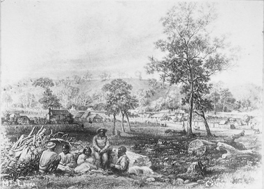
Photograph - Etching of early Camperdown scene, Mt Leura Camperdown, c1850s
... ...Mt Sugarloaf...Sugarloaf. Camperdown was surveyed by Robert Dunbar Scott in 1851. First dwelling constructed by David Fenton in 1853 on site of Commercial Hotel. CDHS Djargurd Wurrung Djargurdwurrung Mount Leura Mt ...This etching was created of Camperdown c1850s showing a group of First Nations people and early dwellings and native vegetation around Mounts Leura and Sugarloaf. Camperdown was surveyed by Robert Dunbar Scott in 1851. First dwelling constructed by David Fenton in 1853 on site of Commercial Hotel. Etching of early Camperdown scene showing group of First Nations people in the foreground with early buildings, native vegetation and Mount Leura and Mount Sugarloaf in the background. On front: Mt Leura, Camperdowncdhs, djargurd wurrung, djargurdwurrung, mount leura, mt leura, mount sugarloaf, mt sugarloaf, cdhsfirstnations -
 Camperdown & District Historical Society
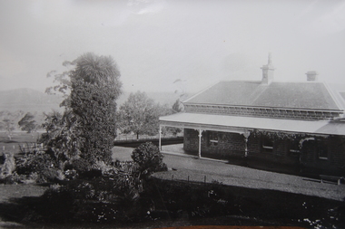
Photograph - Renny Hill homestead, Camperdown, c1890s
... Mt Sugarloaf...In 1883 he gifted the world's oldest statue of Robert Burns to the people of Camperdown. Mt Sugarloaf Mount Sugarloaf CDHS Renny Hill Djargurd Wurrung Djargurdwurrung CDHSFirstNations Renny Hill built 1876? ...''Renny Hill'', built c1876, was the home of William Andrew Taylor (1849-1927) and Isabella Park Taylor, nee Dawson (1842-1929). Isabella was a friend to First Nations people and together with her father, James Dawson, recorded their languages and customs. William Taylor was a farmer, Councillor and civic leader. In 1883 he gifted the world's oldest statue of Robert Burns to the people of Camperdown.Black and white image of ''Renny Hill'' homestead, Camperdown Renny Hill built 1876? Built for Isabella Park (Dawson) Taylor and William Taylormt sugarloaf, mount sugarloaf, cdhs, renny hill, djargurd wurrung, djargurdwurrung, cdhsfirstnations -
 Camperdown & District Historical Society
Photograph - Aboriginal people at Mt Leura, Camperdown, c1875
... ...Mt Sugarloaf...Mt Leura, Camperdown c1875. This image also shows early primitive dwellings, Ower's flour mill (built 1868) and surviving native vegetation. CDHS Djargurdwurrung Wombeetch Puyuun Camperdown George Prince Charlie Mount Leura Mount Sugarloaf Mt Sugarloaf Ower's Mill CDHSFirstNations On back: Early 1870s, Bought at first land sale Cr Scott & Curdie St, F.H. ...Three Djargurd Wurrung people on Country, pictured in front of Mt Leura, Camperdown c1875. This image also shows early primitive dwellings, Ower's flour mill (built 1868) and surviving native vegetation. Image of three Djargurd Wurrung people seated in front of Mt Leura, Camperdown, taken near corner of Scott and Curdie Streets c1875. On back: Early 1870s, Bought at first land sale Cr Scott & Curdie St, F.H. Grant, 11 Adeney Streetcdhs, djargurdwurrung, wombeetch puyuun, camperdown george, prince charlie, mount leura, mount sugarloaf, mt sugarloaf, ower's mill, cdhsfirstnations -
 Bendigo Historical Society Inc.
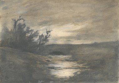
Drawing - HARRIS COLLECTION: CHARCOAL SKETCH AXE CREEK, AXEDALE
... Most probably sketch of Harris property, orchard and vineyard on Axe Creek, Mt. Sugarloaf Road, Axedale....Most probably sketch of Harris property, orchard and vineyard on Axe Creek, Mt. Sugarloaf Road, Axedale. Drawing HARRIS COLLECTION: CHARCOAL SKETCH AXE CREEK, AXEDALE ...Charcoal sketch on cream background of water course, trees on left hand side. Most probably sketch of Harris property, orchard and vineyard on Axe Creek, Mt. Sugarloaf Road, Axedale.George Harris, Axedaleartwork, axedale, george harris -
 Bendigo Historical Society Inc.
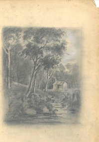
Drawing - HARRIS COLLECTION: CHARCOAL SKETCH OF CREEK AND HUT
... Most probably a depiction of the Harris orchard/vineyard on Axe Creek, Axedale, near the bridge on the Mt. Sugarloaf Road....Most probably a depiction of the Harris orchard/vineyard on Axe Creek, Axedale, near the bridge on the Mt. Sugarloaf Road. Drawing HARRIS COLLECTION: CHARCOAL SKETCH OF CREEK AND HUT ...Charcoal sketch on cream background of creek, small hut on bank, eucalypts on LH side and in background. Most probably a depiction of the Harris orchard/vineyard on Axe Creek, Axedale, near the bridge on the Mt. Sugarloaf Road.George Harris, Axedaleartwork, harris vineyard -
 Eltham District Historical Society Inc
Album - Photo Album, Ruth Pendavingh, Take Heart, Nillumbik, 1998-2002
... Mt Cooper...New Eltham Diabetes Contact Group...Parkinson Support Group...Picnic...Ruth Pendavingh...Scienceworks...Sugarloaf...Eltham District Historical Society Inc 728 Main Rd Eltham melbourne Album of photographs associated with activities of the Cardiac Rehab "Take Heart" Group including the Arthritis Group (Land and Water exercise) managed by Eltham Community Health Centre Allied Health Assistant Arthritis Group (Land and Water Exercise) Arthritis Group Arthurs Creek Betty Willis Bundoora Park Cardiac Rehab 'Take Heart' Group Christmas Break-up diamond valley railway Dirk Pendavingh Elizabeth Dick Eltham Community Health Centre Eltham Health Group Eltham Leisure Centre Eltham Lower Park Eltham Ernie Robinson Fairfield Park Fairfield Flagstaff Hill Griffiths Park Ken Willis Lavender Farm Migrant teachers Mt Cooper New Eltham Diabetes Contact Group Parkinson Support Group Picnic Ruth Pendavingh Scienceworks Sugarloaf Reservoir Veronica White-Hall warringal Water Exercise Group warrrnambool warrnambool RSL Floral print cover, 21.5 x 17.5 x 1.5 cm; 32 pages each containing two 10 x 15cm prints in platsic slips. 68 images Take Heart, Nillumbik Album Photo Album Ruth Pendavingh ...Album of photographs associated with activities of the Cardiac Rehab "Take Heart" Group including the Arthritis Group (Land and Water exercise) managed by Eltham Community Health Centre allied health assistant, arthritis group (land and water exercise), arthritis group, arthurs creek, betty willis, bundoora park, cardiac rehab 'take heart' group, christmas break-up, diamond valley railway, dirk pendavingh, elizabeth dick, eltham community health centre, eltham health group, eltham leisure centre, eltham lower park, eltham, ernie robinson, fairfield park, fairfield, flagstaff hill, griffiths park, ken willis, lavender farm, migrant teachers, mt cooper, new eltham diabetes contact group, parkinson support group, picnic, ruth pendavingh, scienceworks, sugarloaf reservoir, veronica white-hall, warringal, water exercise group, warrrnambool, warrnambool rsl -
 Eltham District Historical Society Inc
Photograph - Digital Photograph, Alan King, Kinglake National Park, 27 March 2008
... The Sugarloaf and Everard Blocks – of almost 8000 hectares – stand in Nillumbik and the park extends into Mitchell and Murrundindi Shires and the City of Whittlesea. Mt...The Sugarloaf and Everard Blocks – of almost 8000 hectares – stand in Nillumbik and the park extends into Mitchell and Murrundindi Shires and the City of Whittlesea. Mt ...Fern gullies around Jehosaphat Gully Covered under National Estate. Published: Nillumbik Now and Then / Marguerite Marshall 2008; photographs Alan King with Marguerite Marshall.; p125 The magnificent Kinglake National Park, fringing Nillumbik’s north, is the largest national park close to Melbourne. Thanks to the vision and hard work of a band of local people, the park was created from what was rapidly becoming degraded land. Seeing a threat to Kinglake’s indigenous flora and fauna, several prominent local people campaigned for a national park, which was established in 1928.1 Since then, the park has grown through donations and acquisitions of land, from around 13,800 acres of land (5585ha) to 22,360 hectares. The Sugarloaf and Everard Blocks – of almost 8000 hectares – stand in Nillumbik and the park extends into Mitchell and Murrundindi Shires and the City of Whittlesea. Mt Everard commemorates William Hugh Everard, State member for Evelyn when the park was established. Before 1928, European settlers had degraded the Kinglake area, which was named after the celebrated English author and lawyer, Alexander William Kinglake. Remains of gold shafts and diggings in the park are reminders of Kinglake’s first settlers, who hoped to strike it rich at the gold diggings. But like other gold fields in this shire, they proved not very lucrative and soon timber cutting replaced mining in importance. However, before long, the accessible timber supply ran out, so in the 1920s agriculture took over – particularly potatoes and berry fruits – which involved large-scale clearing.2 The park’s instigator was retired Melbourne University Professor of Music, William Laver.3 As chair of the Kinglake Progress Association he began negotiations to have crown lands on the southern scarp of the Great Dividing Range reserved as a national park. Even before the park was proclaimed, from 1927, KPA members cut tracks to the major scenic points. Professor Laver was one of several people who gave land for the park, donating around 50 acres (20ha), including the Jehosaphat Gully.4 Laver chaired the park’s first Committee of Management, which raised money to employ a ranger and provide facilities, including tracks and roads for fire protection vehicles, toilets and shelters. The committee charged fees for firewood collection, some grazing of livestock, and visitor entrance, and obtained small State Government and Eltham Shire grants. In 1957 the State Government provided revenue for national parks. Then, in 1975, the State Government took over the management and the Committee of Management became an advisory committee, which disbanded in 1978. Originally, the park covered crown land in the Shires of Eltham and Whittlesea; then Wombelano Falls in Yea and other areas were added. In 1970 the park extended into the Shires of Eltham, Healesville, Whittlesea and Yea.5 Bush fires have been an ongoing problem. In 1939 hundreds of eucalypts and acacias had to be sown around the Jehosaphat Gully to rejuvenate the forest. To manage bushfires, the Committee of Management, then the State Government, worked closely with the Forestry Commission, shire councils and local fire brigades. Early national parks focussed on recreation. But by the 1980s, conservation, education and scientific research became more important, playing a vital role in preserving representative samples of the natural environment. Each year many thousands of people use the park’s extensive network of walking tracks amongst the protected plant and animal life as well as camping, cycling and horse riding. The park, along the slopes of the Great Dividing Range, has lookouts revealing magnificent views of the Melbourne skyline, Port Phillip Bay, the Yarra Valley and the You Yangs. Vegetation in the Masons Falls area includes messmate forest, Austral grass-trees, ferns and Hazel Pomaderris. In spring, orchids, lilies, everlasting daisies, correas, grevillea and heath appear. Around Jehosaphat Gully are wet and dry forest, fern gullies and banksia. Animal life includes wallabies, kangaroos, koalas, echidnas, possums, gliders and bandicoots. Male lyrebirds can be heard mimicking in the Jehosaphat Gully, particularly in the Everard Block in winter.This collection of almost 130 photos about places and people within the Shire of Nillumbik, an urban and rural municipality in Melbourne's north, contributes to an understanding of the history of the Shire. Published in 2008 immediately prior to the Black Saturday bushfires of February 7, 2009, it documents sites that were impacted, and in some cases destroyed by the fires. It includes photographs taken especially for the publication, creating a unique time capsule representing the Shire in the early 21st century. It remains the most recent comprehenesive publication devoted to the Shire's history connecting local residents to the past. nillumbik now and then (marshall-king) collection, kinglake national park, jehosaphat gully -
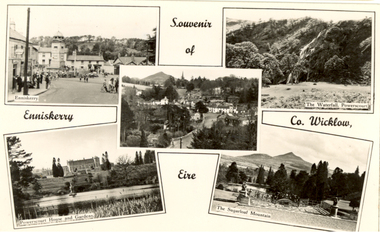 Federation University Historical Collection
Postcards - black and white, Souvenir of Enniskerry, County Wicklow, Eire
... Mt Helen Campus Federation University Australia E.J. Barker Library (top floor) Mount Helen goldfields chatham family archive enniserry eire wicklow powerscoirt sugarloaf Black and white photographic postcard showing three images of Enniskerry, County Wicklow, Eire Souvenir of Enniskerry, County Wicklow, Eire Postcards - black and white ...Black and white photographic postcard showing three images of Enniskerry, County Wicklow, Eirechatham family archive, enniserry, eire, wicklow, powerscoirt, sugarloaf -
Federation University Historical Collection
Reports, Thylacines and Large Predators Sightings, 1950-2011, 1950-2011
... mt barker...mike voss...ernie palm...southern pantgher...yowie...min min...mongarlowe river...monga state forest...john reid...thylacine...prospect reservoir...sugarloaf...The folder was collected for research being conducted by David Waldron. australian mythical animals collection david waldron tiger greenwald tasmanian tiger roberts wadsworth mary wadsworth portland leo gillick merino ann matthews h. mincham footprint helena lucas cape bridgewater wilbert wilson puma paw rocklands reservoir paw cast emmaville panther mulgoa jack victory samela harris narrabri c.j. johnson wandsworth robertson edward hallstron yetman d. liddicoot f. hallam liger ben lomand ben lomand panther methvern park john hutton black mountain elvy adams joe clifford armidale australian marsupial cat glenn innes barraba manilla uralla stan wyatt ashford emaville kingston laurence miller a.t. o'farrell pad marks edward hallstrom tasmanian devil wonthaggi jim drodge cyril maurier j. wright jack brennocks marsupial wolf hyaena b.l. meeby circus animals blue mountains jack duane coff's harbour daylesford lyonville j.r. templeton otways p.w. hunt emmaville panther dingos coolatai panther wilson's promontory hambley-clark mark foster broken hill puma tarnagulla tarnagulla puma jan juc grampians tom croderick clifford andrews bunyip wedderburn john lavery mt korong rare fauna research society peter chappell denmark mt barker mike voss ernie palm southern pantgher yowie min min mongarlowe river monga state forest john reid thylacine prospect reservoir sugarloaf john higgins kyneton ravenswood bendigotom austin hamilton ron strachan samuel wilson albert austin jaguars inverell r.s. paterson ian lobsey black sal new england panther kingstown a.f. o'farrell mile creek Folder of newsclips and articles relating to "Big Cats", Thylacines, and other large predators ...The folder or correspondence is the result of a Freedom of Information request made to the Department of Sustainability and Environment in 2011. The folder was collected for research being conducted by David Waldron.Folder of newsclips and articles relating to "Big Cats", Thylacines, and other large predators. * The Argus, 04 May 1940 - 'Strange Animal a Dog' at Daylesford (Lyonville) sighted by J.R. Templeton australian mythical animals collection, david waldron, tiger, greenwald, tasmanian tiger, roberts wadsworth, mary wadsworth, portland, leo gillick, merino, ann matthews, h. mincham, footprint, helena lucas, cape bridgewater, wilbert wilson, puma paw, rocklands reservoir, paw cast, emmaville, panther, mulgoa, jack victory, samela harris, narrabri, c.j. johnson, wandsworth, robertson, edward hallstron, yetman, d. liddicoot, f. hallam, liger, ben lomand, ben lomand panther, methvern park, john hutton, black mountain, elvy adams, joe clifford, armidale, australian marsupial cat, glenn innes, barraba, manilla, uralla, stan wyatt, ashford, emaville, kingston, laurence miller, a.t. o'farrell, pad marks, edward hallstrom, tasmanian devil, wonthaggi, jim drodge, cyril maurier, j. wright, jack brennocks, marsupial wolf, hyaena, b.l. meeby, circus animals, blue mountains, jack duane, coff's harbour, daylesford, lyonville, j.r. templeton, otways, p.w. hunt, emmaville panther, dingos, coolatai panther, wilson's promontory, hambley-clark, mark foster, broken hill, puma, tarnagulla, tarnagulla puma, jan juc, grampians, tom croderick, clifford andrews, bunyip, wedderburn, john lavery, mt korong, rare fauna research society, peter chappell, denmark, mt barker, mike voss, ernie palm, southern pantgher, yowie, min min, mongarlowe river, monga state forest, john reid, thylacine, prospect reservoir, sugarloaf, john higgins, kyneton, ravenswood, bendigotom austin, hamilton, ron strachan, samuel wilson, albert austin, jaguars, inverell, r.s. paterson, ian lobsey, black sal, new england panther, kingstown, a.f. o'farrell, mile creek -
Federation University Historical Collection
Book, Power and Heat, c1928
... Mt Helen Campus Federation University Australia E.J. Barker Library (top floor) Mount Helen goldfields When this book was published when Sir John Monash was the Chair of the State Electricity Commission of Victoria. State Electricity Commission of Victoria. SEC Yallourn Brown Coal Field power stations power generation Yallourn Open Cut Richmond Power Station Latrobe River yarraville terminal station sugarloaf ...When this book was published when Sir John Monash was the Chair of the State Electricity Commission of Victoria. Small Charcoal soft covered book on the State Electricity Commission of Victoria, Stamped "C.H. Beanland"state electricity commission of victoria., sec, yallourn brown coal field, power stations, power generation, yallourn open cut, richmond power station, latrobe river, yarraville terminal station, sugarloaf-rubicon, royston river, briquetting factory yallourn, briquettes, charles beanland