Showing 76 items matching "mt victory"
-
 Halls Gap & Grampians Historical Society
Photograph - B/W, C 1930s-1940s
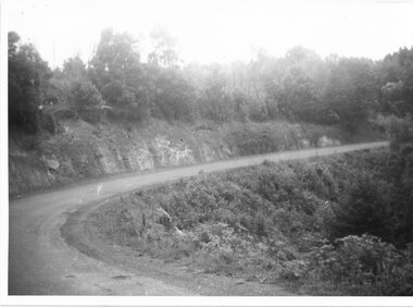
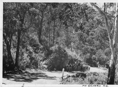
... ...Mt Victory Rd...Mt Victory Rd once known as the Bluff road was opened by Lady Somers Mar 1930. ...photo shows sweeping bend on Mt Victory Rd...This section of the raod is beyond Stoney Creek Gorge ACCESS ROUTES Mt Victory Rd Roads photo shows sweeping bend on Mt Victory Rd Photograph B/W ...Mt Victory Rd once known as the Bluff road was opened by Lady Somers Mar 1930. This section of the raod is beyond Stoney Creek Gorgephoto shows sweeping bend on Mt Victory Rdaccess routes, mt victory rd, roads -
 Stawell Historical Society Inc
Postcard, For Luck Postcard & the Balconies at Mt Victory in the Grampians -- 2 Photos -- Postcards -- 1 Coloured
... For Luck Postcard & the Balconies at Mt Victory in the Grampians -- 2 Photos -- Postcards -- 1 Coloured...The Balconies Mt Victory Grampians...Stawell Historical Society Inc 46 Longfield St Stawell grampians The Balconies Mt Victory Grampians Stawell For Luck Postcard & the Balconies at Mt Victory in the Grampians -- 2 Photos -- Postcards -- 1 Coloured Postcard ...The Balconies Mt Victory Grampiansstawell -
 Stawell Historical Society Inc
Postcard, The Balconies Mt Victory in the Grampians -- Postcard
... The Balconies Mt Victory in the Grampians -- Postcard...The Balconies Mt Victory The Grampians Valentine Series 1024...Mountain views in the background. The Balconies Mt Victory in the Grampians -- Postcard Postcard ...The Balconies Mt Victory The Grampians Valentine Series 1024Black and white photograph of two young people standing between two cliff ledges. Mountain views in the background. Valentine series No. 1024 The Balconies, Mt. Victoria, Grampians Published by the Valentine Publication Co. Pty Ltd. Queens St. Melb.halls gap grampians -
 Stawell Historical Society Inc
Photograph, Stawell “Weekly Times” article about the Opening of Mt Victory Road March 22nd 1930
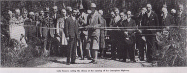
... Stawell “Weekly Times” article about the Opening of Mt Victory Road March 22nd 1930...“Weekly Times” Opening of Mt Victory Road March 22nd 1930...Stawell Historical Society Inc 46 Longfield St Stawell grampians “Weekly Times” Opening of Mt Victory Road March 22nd 1930 Stawell Stawell “Weekly Times” article about the Opening of Mt Victory Road March 22nd 1930 Photograph ...“Weekly Times” Opening of Mt Victory Road March 22nd 1930stawell -
 Halls Gap & Grampians Historical Society
Photograph - B/W, C 1930
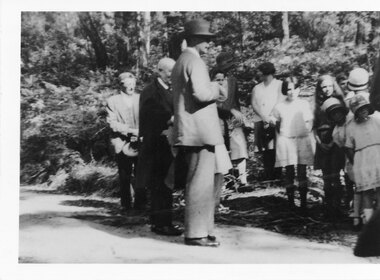
... ...Mt Victory Rd...Official opening of Mt Victory Rd People in photo Lord and Lady Somers, 2 Johsons Millie Bowtell, Bessie McKeon, M Pawsey...Photo shows group standing on road opening of Mt Victory Rd. Lord Somers in foreground...Halls Gap & Grampians Historical Society Centennial Hall 117-119 Grampians Road Halls Gap grampians Official opening of Mt Victory Rd People in photo Lord and Lady Somers, 2 Johsons Millie Bowtell, Bessie McKeon, M Pawsey ACCESS ROUTES Mt Victory Rd PEOPLE Roads Photo shows group standing on road opening of Mt Victory Rd. ...Official opening of Mt Victory Rd People in photo Lord and Lady Somers, 2 Johsons Millie Bowtell, Bessie McKeon, M PawseyPhoto shows group standing on road opening of Mt Victory Rd. Lord Somers in foregroundaccess routes, mt victory rd, people, roads -
 Kew Historical Society Inc
Photograph - Grampians, 1924
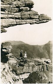
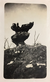
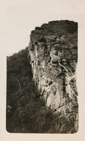
... ...mt victory...This photo is of a self-standing rock on what is probably the Mt Victory trail. ..."Mt Victory / Grampians / 9.24"...This photo is of a self-standing rock on what is probably the Mt Victory trail. Photograph Grampians ...Henry Beater Christian (1886-1962) , was a descendant of one of the earliest settler families in Kew. Employed at the Kew Asylum as a 'public servant', he was a skilled amateur photographer, photographing numerous scenes in Kew and on his travels around Victoria. The majority of his photographs date from 1916 to 1929. His finest photographs are housed in two photograph albums. Digital copy of a photograph from page 12 of the 47-page photograph album containing 261 gelatinous silver images, loaned by Diane Washfold with permission given to digitise and hold a copy in our collection. The first and last pages in the album document the Yarra River at Studley Park and at Kew. The remainder of the album includes photographs of walking and car tours in rural Victoria including 'wilderness' areas in the Grampians, Gippsland and the High Country. Six album pages document a camping trip by Henry Christian to the Grampians in September 1924. The photos include pictures of lookouts, and natural features including rock faces and waterfalls, as well as his camp site. This photo is of a self-standing rock on what is probably the Mt Victory trail. "Mt Victory / Grampians / 9.24"henry beater christian (1886-1962), landscape photography, christian-washfold collection, photograph albums, grampians, mt victory, gariwerd -
 Kew Historical Society Inc
Photograph - Grampians, 1924
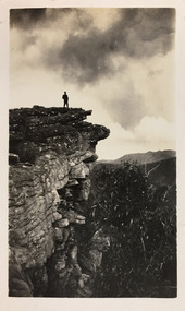
... ...mt victory...This photo is of a man, perhaps Henry Christian, standing on one of the lookouts on what is probably the Mt Victory trail. ..."Mt Victory / Grampians / 9.24"...This photo is of a man, perhaps Henry Christian, standing on one of the lookouts on what is probably the Mt Victory trail. Photograph Grampians ...Henry Beater Christian (1886-1962) , was a descendant of one of the earliest settler families in Kew. Employed at the Kew Asylum as a 'public servant', he was a skilled amateur photographer, photographing numerous scenes in Kew and on his travels around Victoria. The majority of his photographs date from 1916 to 1929. His finest photographs are housed in two photograph albums. Digital copy of a photograph from page 12 of the 47-page photograph album containing 261 gelatinous silver images, loaned by Diane Washfold with permission given to digitise and hold a copy in our collection. The first and last pages in the album document the Yarra River at Studley Park and at Kew. The remainder of the album includes photographs of walking and car tours in rural Victoria including 'wilderness' areas in the Grampians, Gippsland and the High Country. Six album pages document a camping trip by Henry Christian to the Grampians in September 1924. The photos include pictures of lookouts, and natural features including rock faces and waterfalls, as well as his camp site. This photo is of a man, perhaps Henry Christian, standing on one of the lookouts on what is probably the Mt Victory trail. "Mt Victory / Grampians / 9.24"henry beater christian (1886-1962), landscape photography, christian-washfold collection, photograph albums, grampians, mt victory, gariwerd -
 Kew Historical Society Inc
Photograph - Grampians, 1924
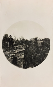
... ...mt victory...This photo is of a man, perhaps Henry Christian, holding his camera while standing on one of the lookouts on what is probably the Mt Victory trail. The photo was framed in a circle during the development process. ..."Mt Victory / Grampians / 9.24"...His finest photographs are housed in two photograph albums. henry beater christian (1886-1962) landscape photography christian-washfold collection photograph albums grampians mt victory gariwerd "Mt Victory / Grampians / 9.24" Digital copy of a photograph from page 12 of the 47-page photograph album containing 261 gelatinous silver images, loaned by Diane Washfold with permission given to digitise and hold a copy in our collection. ...Henry Beater Christian (1886-1962) , was a descendant of one of the earliest settler families in Kew. Employed at the Kew Asylum as a 'public servant', he was a skilled amateur photographer, photographing numerous scenes in Kew and on his travels around Victoria. The majority of his photographs date from 1916 to 1929. His finest photographs are housed in two photograph albums. Digital copy of a photograph from page 12 of the 47-page photograph album containing 261 gelatinous silver images, loaned by Diane Washfold with permission given to digitise and hold a copy in our collection. The first and last pages in the album document the Yarra River at Studley Park and at Kew. The remainder of the album includes photographs of walking and car tours in rural Victoria including 'wilderness' areas in the Grampians, Gippsland and the High Country. Six album pages document a camping trip by Henry Christian to the Grampians in September 1924. The photos include pictures of lookouts, and natural features including rock faces and waterfalls, as well as his camp site. This photo is of a man, perhaps Henry Christian, holding his camera while standing on one of the lookouts on what is probably the Mt Victory trail. The photo was framed in a circle during the development process. "Mt Victory / Grampians / 9.24"henry beater christian (1886-1962), landscape photography, christian-washfold collection, photograph albums, grampians, mt victory, gariwerd -
 Halls Gap & Grampians Historical Society
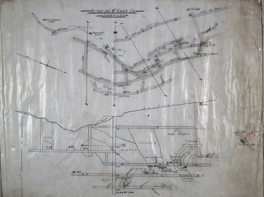
Map - Coloured
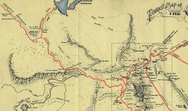
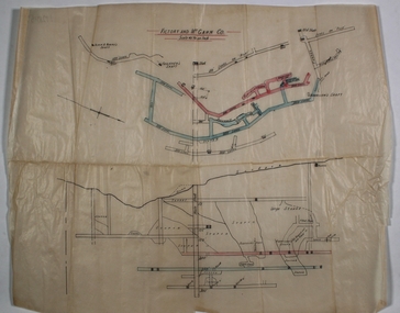
... ...Mt Victory Rd...To this end, the Bluff Road was improved and extended on 1929 and at its opening in March, 1930, by Lady Somers it was renamed the Mt. Victory Road....Map of Mt Victory Road and others...To this end, the Bluff Road was improved and extended on 1929 and at its opening in March, 1930, by Lady Somers it was renamed the Mt. Victory Road. ACCESS ROUTES Mt Victory Rd Bridle Path Roads Map of Mt Victory Road and others Map Coloured ...Background on Bridle Path up Stony Creek Gorge Pre 1840 C. B. Hall, squatter on Mokepilly Run 1841-1842, first European to discover the Fyans Creek valley, the entrance of which became known as Hall's Gap. He later recorded that he followed a number of tracks which he assumed had been made by the Aboriginies and described one as "leading up a wild romantic glen and over on to the source of the Glenelg River". This could well have been the route taken up Stony Creek gorge by the first timber-cutters in this part of the Grampians to the saddle between the Wonderland and Mt. Difficult ranges known as Valley Gap 1850s/60s Timber cutters and shingle splitters were reported to be moving into the eastern side of the Grampians and by the mid 1860s there were a number of families connected to the supplying of timber to Pleasant Creek living in the "Hall's Gap ranges". John Wakeham, the first store owner in Pleasant Creek in 1854, established a timer-mill in upper Stony Creek Gorge in the late 1850s. Wakeham is credited for the clearing and levelling of the first bridle-path up the gorge. 1870s By the mid 1870s the track had been extended over Valley Gap to the Victoria Forest (the upper region of the Victoria Valley). McKeon's bullock team was known to have hauled red gum from the Valley to Stawell in the late 1870s and the 1880s. 1880s In 1887 an article in the Pleasant Creek news describes the Stony Creek Gorge track as "being a ledge alongside the mountain range, formed in the early days with the aid of earth and timber, along which the bullock teams used to travel to Horsham and plains of the Wimmera beyond." 1890s Gold was discovered in the catchment area of Stony Creek and by the end of the 1890s a new track was built from "near the junction of Fyan's and Stony Creeks, up the gorge to the diggings settlement. The mining Department had paid L300 for its construction and, when completed, the track was "three miles and 30 chains in length, the side cuttings at the narrowest part being 10 feet between" and "the watercourses which cross the track at various points" having been "filled up with rocks rolled down the sides of the hills, and consequently there can be no damage caused by bushfires which destroyed the former wooden bridges erected on the old track to Wakeham's saw-mill, the remains of which are still to be seen at the side of the diggings" The article goes on to further describe the track as one which "can with ease travel with a two horse conveyance either up or down" and that the workmen engaged in the construction of the track would be attending "a ball that night at McKeon's farm near the mouth of the gap to celebrate the successful completion of the undertaking". 1900s At what time the bridle path was extended beyond Valley Gap to the Wartook basin on the Mt. Difficult Range has not yet been determined. However, it is known that, by the turn of the century, people were travelling between Halls Gap and the caretakers' residence at Wartook Reservoir along what was now known as the "Bluff Road. Wartook's embankment had been constructed in 1887 and at that time there was already a track from Rosebrook Station homestead (near the present day Wartook Pottery) to the reservoir. Philip Rose owned both Rosebrook and Wartook Stations from the mid 1840s to the late 1850s and had regularly leased the Wartook basin to Cobb & Co. to rest horses there. 1920s Following the war of 1914-1918, tourism really took off in the Grampians, and Halls Gap rapidly grew. People would travel as far as they could on the many tracks then hike to the many lookouts being discovered by local tour guides. This led to the need for access across the range so that horse riders and the increasing number of vehicles could travel between Horsham and Halls Gap. To this end, the Bluff Road was improved and extended on 1929 and at its opening in March, 1930, by Lady Somers it was renamed the Mt. Victory Road.Map of Mt Victory Road and othersaccess routes, mt victory rd, bridle path, roads -
 Kew Historical Society Inc
Photograph - Campsite in the Grampians, 1924
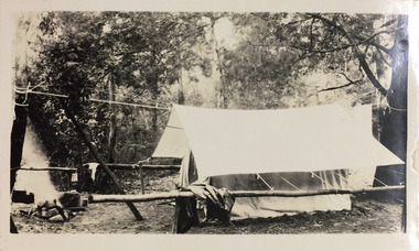
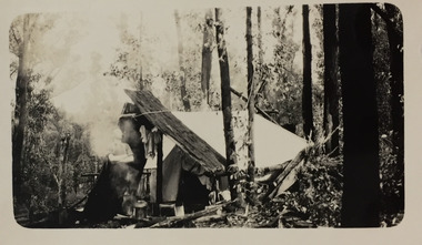
... ...mt victory..."Mt Victory / Grampians / 9.24"...His finest photographs are housed in two photograph albums. henry beater christian (1886-1962) landscape photography christian-washfold collection photograph albums grampians mt victory gariwerd "Mt Victory / Grampians / 9.24" Digital copy of a photograph from page 12 of the 47-page photograph album containing 261 gelatinous silver images, loaned by Diane Washfold with permission given to digitise and hold a copy in our collection. ...Henry Beater Christian (1886-1962) , was a descendant of one of the earliest settler families in Kew. Employed at the Kew Asylum as a 'public servant', he was a skilled amateur photographer, photographing numerous scenes in Kew and on his travels around Victoria. The majority of his photographs date from 1916 to 1929. His finest photographs are housed in two photograph albums. Digital copy of a photograph from page 12 of the 47-page photograph album containing 261 gelatinous silver images, loaned by Diane Washfold with permission given to digitise and hold a copy in our collection. The first and last pages in the album document the Yarra River at Studley Park and at Kew. The remainder of the album includes photographs of walking and car tours in rural Victoria including 'wilderness' areas in the Grampians, Gippsland and the High Country. Six album pages document a camping trip by Henry Christian to the Grampians in September 1924. The photos include pictures of lookouts, and natural features including rock faces and waterfalls, as well as his camp site. This photo is of one of his campsites. The tent, beside which a man is standing, is a simple canvas sheet held up by ropes and supported at one end by large slabs of bark. "Mt Victory / Grampians / 9.24"henry beater christian (1886-1962), landscape photography, christian-washfold collection, photograph albums, grampians, mt victory, gariwerd -
 Kew Historical Society Inc
Photograph - Campsite in the Grampians, 1924
... ...mt victory..."Mt Victory / Grampians / 9.24"...His finest photographs are housed in two photograph albums. henry beater christian (1886-1962) landscape photography christian-washfold collection photograph albums grampians mt victory gariwerd "Mt Victory / Grampians / 9.24" Digital copy of a photograph from page 12 of the 47-page photograph album containing 261 gelatinous silver images, loaned by Diane Washfold with permission given to digitise and hold a copy in our collection. ...Henry Beater Christian (1886-1962) , was a descendant of one of the earliest settler families in Kew. Employed at the Kew Asylum as a 'public servant', he was a skilled amateur photographer, photographing numerous scenes in Kew and on his travels around Victoria. The majority of his photographs date from 1916 to 1929. His finest photographs are housed in two photograph albums. Digital copy of a photograph from page 12 of the 47-page photograph album containing 261 gelatinous silver images, loaned by Diane Washfold with permission given to digitise and hold a copy in our collection. The first and last pages in the album document the Yarra River at Studley Park and at Kew. The remainder of the album includes photographs of walking and car tours in rural Victoria including 'wilderness' areas in the Grampians, Gippsland and the High Country. Six album pages document a camping trip by Henry Christian to the Grampians in September 1924. The photos include pictures of lookouts, and natural features including rock faces and waterfalls, as well as his camp site. This photo is of one of his campsites. The tent, beside which a man is standing, is a simple canvas sheet is supported by saplings and ropes. "Mt Victory / Grampians / 9.24"henry beater christian (1886-1962), landscape photography, christian-washfold collection, photograph albums, grampians, mt victory, gariwerd -
 Halls Gap & Grampians Historical Society
Postcard - Sepia, C 1920s
... ...Mt Victory Rd...Postcard shows Mt Victory Rd unsealed Elephant's hide on left...Sections of the earlier 19th century bridal track, which was later widened to become a jinker track, can be seen above the new road. ACCESS ROUTES Mt Victory Rd Roads Postcard Correspondence Address only Kodak Mt Vic Road Postcard shows Mt Victory Rd unsealed Elephant's hide on left Postcard Sepia ...The road winding up Stoney Creek Gorge with Elephant Hide, the rocky slope in the picture, on the left. Sections of the earlier 19th century bridal track, which was later widened to become a jinker track, can be seen above the new road.Postcard shows Mt Victory Rd unsealed Elephant's hide on leftPostcard Correspondence Address only Kodak Mt Vic Roadaccess routes, mt victory rd, roads -
 Halls Gap & Grampians Historical Society
Photograph - B/W, C 1930s-1940s
... ...Mt Victory Rd...Photo shows 6 people walking up Mt Victory Road Road not sealed...Halls Gap & Grampians Historical Society Centennial Hall 117-119 Grampians Road Halls Gap grampians ACCESS ROUTES Mt Victory Rd Roads Photo shows 6 people walking up Mt Victory Road Road not sealed Photograph B/W ...Photo shows 6 people walking up Mt Victory Road Road not sealedaccess routes, mt victory rd, roads -
 Halls Gap & Grampians Historical Society
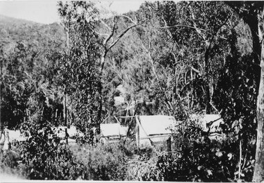
Photograph - Sepia, C 1920s
... Photo is said to be that of roadmakers camp for workers on the construction of the Mt Victory Road...Road makers camp Mt Victory Rd during the dat 1920s...Halls Gap & Grampians Historical Society Centennial Hall 117-119 Grampians Road Halls Gap grampians Photo is said to be that of roadmakers camp for workers on the construction of the Mt Victory Road STRUCTURES Tents ACCESS ROUTES Road building Road makers camp Mt Victory Rd during the dat 1920s Photo shows a number of tents in bush land, said to be road makers camp Photograph Sepia ...Photo is said to be that of roadmakers camp for workers on the construction of the Mt Victory RoadPhoto shows a number of tents in bush land, said to be road makers campRoad makers camp Mt Victory Rd during the dat 1920sstructures, tents, access routes, road building -
 Bendigo Historical Society Inc.
Plan - Victory and Mt. Gahn Co
... Victory and Mt. Gahn Co....Victory and Mt. Gahn Co. was located near Pambula, New South Wales. ...Victory and Mt. Gahn Co. mine workings. Plan shows longitudinal section and, secondly, plan of underground workings on the horizontal plane. ...Victory and Mt. Gahn Co. was located near Pambula, New South Wales. ...Victory and Mt. Gahn Co. was located near Pambula, New South Wales. Victory and Mt. Gahn Co. mine workings. Plan shows longitudinal section and, secondly, plan of underground workings on the horizontal plane. Written on top of plan: 'Victory and Mt. Gahn Co. 40 ft to and inch' Plan forms part of the Margaret Roberts Collection of mining records. margaret roberts, gold, gold mine, victory and mt.gahn -
 Halls Gap & Grampians Historical Society
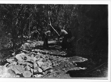
Photograph - B/W, C 1920s
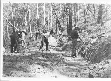
... Men have started to form the Mt Victory Road. Until the 1900's access to the Stoney Creek gorge was via a winding bridal jinker track. ...Pick and shovel Mt Victory Rd...ACCESS ROUTES Roads ACCESS ROUTES Road building Pick and shovel Mt Victory Rd Photo shows 3 men working with pick and shovel on road Photograph B/W ...Men have started to form the Mt Victory Road. Until the 1900's access to the Stoney Creek gorge was via a winding bridal jinker track. Increased traffic lead to much of this route being widened into what became known as Bluff Road. Within a few years the route was further improved and was officially named Mount Victory Road in 1930.Photo shows 3 men working with pick and shovel on roadPick and shovel Mt Victory Rdaccess routes, roads, access routes, road building -
 Bendigo Historical Society Inc.
Plan - Victory and Mt. Gahn Gold Mining Co
... Victory and Mt. Gahn Gold Mining Co.......Victory and Mt Gahn Gold Mine...On 9th April, 1915, the Victory and Mt. Gahn mine, Pambula, mine workings were reported on by McColl, Rankin and Stanistreet in the Bendigo Advertiser. ...Victory and Mt. Gahn Gold Mining Co. Plan forms part of the Margaret Roberts Collection....Rankin was the Legal Manager of the mine. gold mining gold Bendigo Victory and Mt Gahn Gold Mine Pambula Victory and Mt. ...On 9th April, 1915, the Victory and Mt. Gahn mine, Pambula, mine workings were reported on by McColl, Rankin and Stanistreet in the Bendigo Advertiser. Mr. R.A. Rankin was the Legal Manager of the mine.Victory and Mt. Gahn Gold Mining Co. Plan forms part of the Margaret Roberts Collection.gold mining, gold, bendigo, victory and mt gahn gold mine, pambula -
 Halls Gap & Grampians Historical Society
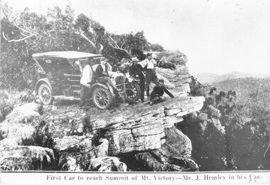
Photograph
... Photo shows the first car (a Buick) to reach summit of Mt Victory. The car was owned by Mr J Hemley. ...First car to reach summit of Mt Victory - Mr J. Hemley in his car...TRANSPORT Cars First car to reach summit of Mt Victory - Mr J. Hemley in his car Photo shows a car parked on rocky outcrop. ...Photo shows the first car (a Buick) to reach summit of Mt Victory. The car was owned by Mr J Hemley. One copy is a slide in slide box 303.Photo shows a car parked on rocky outcrop. Five men are standing near the car.First car to reach summit of Mt Victory - Mr J. Hemley in his cartransport, cars -
 Halls Gap & Grampians Historical Society
Photograph - B/W
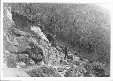
... ...Mt Victory Rd...Both are standing on new & rough section of Mt Victory Rd. Dog in foreground....Both are standing on new & rough section of Mt Victory Rd. Dog in foreground. Photograph B/W ...Photo shows Charles D'Alton (left) and Fred Paasch (right & seated) looking at a point in the distance. Fred Paasch has arm raised & finger pointed. Both are standing on new & rough section of Mt Victory Rd. Dog in foreground.Charles D'Alton & Frederick Paasch (white hat)access routes, mt victory rd -
 Halls Gap & Grampians Historical Society
Photograph - Sepia, C 1930s
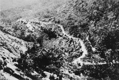
... The Mt Victory Rd was originally called the Bluff Road After improvements and extension it was renamed at its opening by Lady Somers in Mar 1930...Photo shows the newly formed Mt Victory Rd. with the bridle track above it Photo taken from the top of the Elephant's hide...Halls Gap & Grampians Historical Society Centennial Hall 117-119 Grampians Road Halls Gap grampians The Mt Victory Rd was originally called the Bluff Road After improvements and extension it was renamed at its opening by Lady Somers in Mar 1930 ACCESS ROUTES Roads Photo shows the newly formed Mt Victory Rd. with the bridle track above it Photo taken from the top of the Elephant's hide Photograph Sepia ...The Mt Victory Rd was originally called the Bluff Road After improvements and extension it was renamed at its opening by Lady Somers in Mar 1930Photo shows the newly formed Mt Victory Rd. with the bridle track above it Photo taken from the top of the Elephant's hideaccess routes, roads -
 Halls Gap & Grampians Historical Society
Photograph, C 1920s
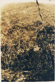
... ...mt victory rd...This is a photo of the Mt. Victory Road under construction. The workers camp can be seen in front of the road. ...Note: The second copy is a transparency held at Slide Box No. 162. access routes mt victory rd The photo shows a slope covered in thick bush. ...This is a photo of the Mt. Victory Road under construction. The workers camp can be seen in front of the road. For further information see 'Victoria's Wonderland', pp 102, 112 & 136. Note: The second copy is a transparency held at Slide Box No. 162.The photo shows a slope covered in thick bush. A road can just be seen in the middle foreground and a campsite with many tents can be seen through the bush in front of the road.access routes, mt victory rd -
 Bendigo Historical Society Inc.
Plan - Victory and Mt. Gahn Co
... Victory and Mt. Gahn Co.......Victory and Mt. Gahn Co....The Victory and Mt. Gahn Mine was near Pambula, New South Wales. ...Printed on top of plan: Victory and Mt. Gahn Co., 40' to and inch. Plan shows a. mine workings on a horizontal plane and b. ...The Victory and Mt. Gahn Mine was near Pambula, New South Wales. ...The Victory and Mt. Gahn Mine was near Pambula, New South Wales. An image of the name plate is available on: https://teaghan11.wixsite.com/encyc-sehistory/victory-gm-company-signPrinted on top of plan: Victory and Mt. Gahn Co., 40' to and inch. Plan shows a. mine workings on a horizontal plane and b. transverse section. Stopes are coloured in blue and red. No key shown. Plan forms part of the Margaret Roberts Collection of mining records. margaret roberts, gold, gold mine, bendigo, victory and mt. gahn co., pambula -
Bendigo Historical Society Inc.
Plan - Victory and Mt. Gahn Gold Mining Co
... Victory and Mt. Gahn Gold Mining Co.......Victory and Mt. Gahn Gold Mine...Plan Victory and Mt. Gahn Gold Mining Co. ...Plan forms part of the Margaret Roberts Collection.gold mining, gold, victory and mt. gahn gold mine -
 Kew Historical Society Inc
Photograph - Grampians, 1924
... ...mt victory...His finest photographs are housed in two photograph albums. henry beater christian (1886-1962) landscape photography christian-washfold collection photograph albums grampians mt victory gariwerd Unitled [Grampians] Digital copy of a photograph from page 13 of the 47-page photograph album containing 261 gelatinous silver images, loaned by Diane Washfold with permission given to digitise and hold a copy in our collection. ...Henry Beater Christian (1886-1962) , was a descendant of one of the earliest settler families in Kew. Employed at the Kew Asylum as a 'public servant', he was a skilled amateur photographer, photographing numerous scenes in Kew and on his travels around Victoria. The majority of his photographs date from 1916 to 1929. His finest photographs are housed in two photograph albums. Digital copy of a photograph from page 13 of the 47-page photograph album containing 261 gelatinous silver images, loaned by Diane Washfold with permission given to digitise and hold a copy in our collection. The first and last pages in the album document the Yarra River at Studley Park and at Kew. The remainder of the album includes photographs of walking and car tours in rural Victoria including 'wilderness' areas in the Grampians, Gippsland and the High Country. Six album pages document a camping trip by Henry Christian to the Grampians in September 1924. The photos include pictures of lookouts, and natural features including rock faces and waterfalls, as well as his camp site. This photo is of one of a well-known cliff face on one of the walking trails. Unitled [Grampians]henry beater christian (1886-1962), landscape photography, christian-washfold collection, photograph albums, grampians, mt victory, gariwerd -
 Kew Historical Society Inc
Photograph - Grampians, 1924
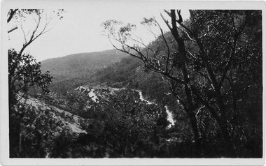
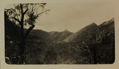
... ...mt victory...His finest photographs are housed in two photograph albums. henry beater christian (1886-1962) landscape photography christian-washfold collection photograph albums grampians mt victory gariwerd "Grampians" Digital copy of a photograph from page 15 of the 47-page photograph album containing 261 gelatinous silver images, loaned by Diane Washfold with permission given to digitise and hold a copy in our collection. ...Henry Beater Christian (1886-1962) , was a descendant of one of the earliest settler families in Kew. Employed at the Kew Asylum as a 'public servant', he was a skilled amateur photographer, photographing numerous scenes in Kew and on his travels around Victoria. The majority of his photographs date from 1916 to 1929. His finest photographs are housed in two photograph albums. Digital copy of a photograph from page 15 of the 47-page photograph album containing 261 gelatinous silver images, loaned by Diane Washfold with permission given to digitise and hold a copy in our collection. The first and last pages in the album document the Yarra River at Studley Park and at Kew. The remainder of the album includes photographs of walking and car tours in rural Victoria including 'wilderness' areas in the Grampians, Gippsland and the High Country. Six album pages document a camping trip by Henry Christian to the Grampians in September 1924. The photos include pictures of lookouts, and natural features including rock faces and waterfalls, as well as his camp site. This photo is a long distance view of the mountains with trees framing the picture in the foreground. "Grampians"henry beater christian (1886-1962), landscape photography, christian-washfold collection, photograph albums, grampians, mt victory, gariwerd -
 Kew Historical Society Inc
Photograph - Campsite in the Grampians, 1924
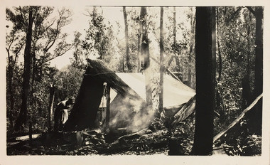
... ...mt victory...His finest photographs are housed in two photograph albums. henry beater christian (1886-1962) landscape photography christian-washfold collection photograph albums grampians mt victory gariwerd "Grampians" Digital copy of a photograph from page 15 of the 47-page photograph album containing 261 gelatinous silver images, loaned by Diane Washfold with permission given to digitise and hold a copy in our collection. ...Henry Beater Christian (1886-1962) , was a descendant of one of the earliest settler families in Kew. Employed at the Kew Asylum as a 'public servant', he was a skilled amateur photographer, photographing numerous scenes in Kew and on his travels around Victoria. The majority of his photographs date from 1916 to 1929. His finest photographs are housed in two photograph albums. Digital copy of a photograph from page 15 of the 47-page photograph album containing 261 gelatinous silver images, loaned by Diane Washfold with permission given to digitise and hold a copy in our collection. The first and last pages in the album document the Yarra River at Studley Park and at Kew. The remainder of the album includes photographs of walking and car tours in rural Victoria including 'wilderness' areas in the Grampians, Gippsland and the High Country. Six album pages document a camping trip by Henry Christian to the Grampians in September 1924. The photos include pictures of lookouts, and natural features including rock faces and waterfalls, as well as his camp site. This photo is of a campsite with a pitched tent supported by slabs of bark and ropes. A man is standing in front of the tent partly obscured by the smoke."Grampians"henry beater christian (1886-1962), landscape photography, christian-washfold collection, photograph albums, grampians, mt victory, gariwerd -
 Halls Gap & Grampians Historical Society
Photograph - B/W, C 1920s
... Mt Victory road in the the making 1920s Commencement of My Victory rod Charles D/Alton, Fred Paasch...ACCESS ROUTES Roads ACCESS ROUTES Road building Mt Victory road in the the making 1920s Commencement of My Victory rod Charles D/Alton, Fred Paasch Photo shows 4 men engaged in road building Two have picks, a third is using a shovel The fourth is chopping a tree Photograph B/W ...See r record 140 for historical information on the building of Mount Victory Road. Two of the men in the photo are Charles D'Alton and Fred Paasch, however it is not known which ones they are.Photo shows 4 men engaged in road building Two have picks, a third is using a shovel The fourth is chopping a treeMt Victory road in the the making 1920s Commencement of My Victory rod Charles D/Alton, Fred Paaschaccess routes, roads, access routes, road building -
 Halls Gap & Grampians Historical Society
Photograph - Sepia, C 1920
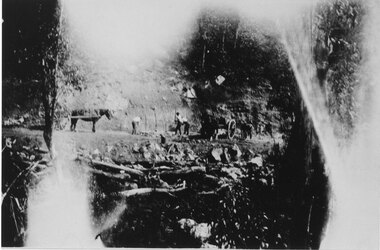
... Photo relates to the building of the Mt Victory Rd during the late 1920s Photo relates to the building of the Mt Victory Road During the late 1920s...Photo relates to the building of the Mt Victory Rd during the late 1920s Photo relates to the building of the Mt Victory Road During the late 1920s ACCESS ROUTES Roads ACCESS ROUTES Road building Photo shows three men with 2 horses and carts A third horse is standing behind one of the carts Men appear to be digging Photograph Sepia ...Men are working at building a road. Photo relates to the building of the Mt Victory Rd during the late 1920s Photo relates to the building of the Mt Victory Road During the late 1920sPhoto shows three men with 2 horses and carts A third horse is standing behind one of the carts Men appear to be digging access routes, roads, access routes, road building -
 Halls Gap & Grampians Historical Society
Photograph - B/W
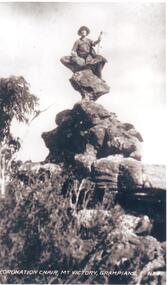
... Coronation Chair, Mt. Victory, Grampians, written on front of photo....Halls Gap & Grampians Historical Society Centennial Hall 117-119 Grampians Road Halls Gap grampians Coronation Chair, Mt. Victory, Grampians, written on front of photo. ...Coronation Chair, Mt. Victory, Grampians, written on front of photo.Woman seated on peculiar corkscrew shaped rock formation,trees with bushes at bottom,sky back ground.scenery, grampians ranges -
 Stawell Historical Society Inc
Booklet, Stawell 7 Grampians Tourist Information, Stawell & Grampians Tourist Information Centre with Typed Tourist Information 1973, 1973
... From the top left line drawing of "Balconies Mt Victory, Grampians" "Town Of" The Stawell Seal " line drawing of the animated lock figures Stawell and Grampians Tourist Information Centre....Stawell Historical Society Inc 46 Longfield St Stawell grampians Town of Stawell issued Pamphlet, containing information for visitors covering the period August - September school holidays 1973. stawell tourism From the top left line drawing of "Balconies Mt Victory, Grampians" "Town Of" The Stawell Seal " line drawing of the animated lock figures Stawell and Grampians Tourist Information Centre. 3 Foolscap yellowed photocopied Stapled Pages Stawell & Grampians Tourist Information Centre with Typed Tourist Information 1973 Booklet Stawell 7 Grampians Tourist Information ...Town of Stawell issued Pamphlet, containing information for visitors covering the period August - September school holidays 1973.3 Foolscap yellowed photocopied Stapled Pages From the top left line drawing of "Balconies Mt Victory, Grampians" "Town Of" The Stawell Seal " line drawing of the animated lock figures Stawell and Grampians Tourist Information Centre.stawell tourism