Showing 7 items matching "mullock tailings"
-
 Bendigo Historical Society Inc.
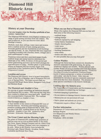
Document - Kangaroo Flat Gold Mine Collection: Diamond Hill Historic Area, Department of Conservation and Environment, April 1991
... ...mullock tailings...Bendigo mining gold City of Greater Bendigo Great Comet Quartz Mining Golden Fleece Quartz Mining Albert Tribute Glasgow Golconda Albert Gold Mining and Crushing Golden Gully Dead Dog Gully German miners British New Chum South Golden Carshalton Hansel Mundy Morning Light mullock tailings stamp battery One page double sided information sheet, produced by Department of Conservation and Environment, April 1991, detailing the mining history of the Diamond Hill area, Kangaroo Flat/Spring Gully area. ...Diamond Hill was a gold mining village 5 km south of Bendigo and about 1 km west of the Spring Gully Reservoir. Its location is now inaccessible and within the water catchment area. Diamond Hill was reputedly named after a diamond shaped rock on the hill. With the development of mining companies which employed workers with families, a school was needed by 1873 and one was opened at the beginning of the next year. The mining companies included Great Comet Quartz Mining, Golden Fleece Quartz Mining, Albert Tribute, Glasgow Golconda, and Albert Gold Mining and Crushing. Mining continued beyond 1900, as recorded in the Australian handbook, 1903. The Bendigo Mining N.L. company was located nearby, adjoining Ham Street. One page double sided information sheet, produced by Department of Conservation and Environment, April 1991, detailing the mining history of the Diamond Hill area, Kangaroo Flat/Spring Gully area. On the back of the sheet: map of the Diamond Hill historic area, showing location of former mining sites. bendigo mining n.l., bendigo, mining, gold, city of greater bendigo, great comet quartz mining, golden fleece quartz mining, albert tribute, glasgow golconda, albert gold mining and crushing, golden gully, dead dog gully, german miners, british new chum, south golden carshalton, hansel mundy, morning light, mullock tailings, stamp battery, -
 Tarnagulla History Archive
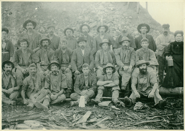
Photograph of workers at a mine at or near Tarnagulla, Workers at a mine at or near Tarnagulla, late 19th Century
... A black and white negative image depicting workers at a mine at or near Tarnagulla. Mullock/tailings heap behind group....This photograph is a reasonable copy created from an older original. tarnagulla workers mining A black and white negative image depicting workers at a mine at or near Tarnagulla. Mullock/tailings heap behind group. Workers at a mine at or near Tarnagulla Photograph of workers at a mine at or near Tarnagulla ...Murray Comrie Collection. This photograph is a reasonable copy created from an older original. A black and white negative image depicting workers at a mine at or near Tarnagulla. Mullock/tailings heap behind group.tarnagulla, workers, mining -
 Ringwood and District Historical Society
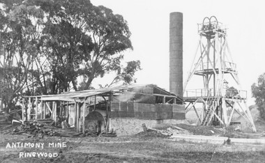
Photograph, Antimony Mine, Ringwood,1920. (Later Civic Centre site)
... Gum trees to left of picture. Mullock heaps ("tailings") around place used extensively in making roads in Ringwood in early days....Gum trees to left of picture. Mullock heaps ("tailings") around place used extensively in making roads in Ringwood in early days. ...Black and white photograph (2 copies- 1 large, 1 postcard size) Image shows mine building and poppet head. Gum trees to left of picture. Mullock heaps ("tailings") around place used extensively in making roads in Ringwood in early days. -
 Ballarat Heritage Services
Photograph - Photograph - Colour, Clare Gervasoni, Nimon's Bridge, 1999, 04/10/1999
... Within close proximity of the bridge are mullock dumps, tailings, shaft sites and other relics of the deep-lead alluvial mining era. ...Within close proximity of the bridge are mullock dumps, tailings, shaft sites and other relics of the deep-lead alluvial mining era. ...Nimons Bridge was built in 1890, as part of the then Ballarat-Linton railway. The bridge is 17 spans with tall timber piers of four driven piles each, with triple sets of diagonal cross-bracing and walers and a single row of longitudinal horizontal bracing between piers. The spans are of a uniform twenty feet (6.1 metres), originally supported by four 21-inch x 9-inch (535 mm x 230 mm) Kauri timber beams per span, following the standard V.R. design of the period. When the superstructure was rebuilt after the 1953 fire, the timber beams were replaced with two 24-inch (610mm) deep rolled-steel-joists on each span. These are marked 'Lancashire Steel Co., Scotland' and are believed to have been second-hand. The deck of transverse-timber planks is 103.6 metres in length. Overall the bridge has an impressive appearance with its exceptionally tall triple-cross-braced piers creating a 'three-tiered' effect, with the deck 19.2 metres above the Woady Yaloak River. The Ballarat-Skipton line closed in 1985. Nimons Bridge has been recently restored, as part of the Ballarat-Skipton Rail Trail. How is it significant? Nimons Bridge is significant for technical, historic and aesthetic reasons at a State level. Why is it significant? Nimons Bridge is technically significant as Victoria's fourth-tallest timber trestle bridge when built, and as the third-tallest surviving example. It is also the second-largest composite bridge combining traditional timber piers with RSJ spans and a timber deck and falls within a select group of fewer than ten timber railway bridges with horizontal longitudinal bracing between the piers and three sets of double cross-bracing on its tallest piers, creating a visually striking 'three tiered' effect that enhances its viaduct form. Nimons Bridge is historically significant as having served initially the mining community at Linton, then the Western District agricultural area and in later years a kaolin quarry at Pittong. Nimons Bridge is historically significant as a representative of the 'light' branch line methodology that stimulated the explosion of railway construction in Victoria during the 1880s, and provides an interesting contrast with the more solid and vastly more expensive railway viaducts built in similar terrain on Victorian main lines, at Moorabool and Taradale, in the late 1850s. Approached by a deep cutting and high embankment at either end, the bridge represents a very cost-effective late 19th century engineering solution to the characteristic physiography of western Victoria with flat basalt plains intersected by deep wide valleys occasionally subject to severe flooding. Nimons Bridge is aesthetically significant for its visually impressive viaduct form, crossing a deep and steep-sided valley that is part of a rich cultural landscape. Within close proximity of the bridge are mullock dumps, tailings, shaft sites and other relics of the deep-lead alluvial mining era. The bridge is the most visually spectacular timber-trestle rail bridge in Western Victoria and is among the most spectacular timber-trestle rail bridges surviving anywhere in Victoria. It is part of the Ballarat-Skipton Rail Trail. Classified by the National Trust :02/10/2000 (http://vhd.heritagecouncil.vic.gov.au/places/67986)Colour photograph of a log bridge known as Nimon's Bridge.ballarat-linton, nimons bridge, nimon's bridge, log bridge, viaduct, timber-trestle rail bridge -
 Rutherglen Historical Society
Image, 1937
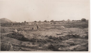
... Slum dam is the same as slime dam or tailings dam. slum dam gold mining tailings dam mining industry great southern On back of photo: "Slum Dam 1937" "Great Southern where tip is now 1986" Black and white photograph of an area of disturbed ground with buildings, horses and a large mullock heap in the background Image ...Part of a collection relating to the Parkin family. Slum dam is the same as slime dam or tailings dam.Black and white photograph of an area of disturbed ground with buildings, horses and a large mullock heap in the backgroundOn back of photo: "Slum Dam 1937" "Great Southern where tip is now 1986"slum dam, gold mining, tailings dam, mining industry, great southern -
 Ballarat Heritage Services
Photograph - Colour Photograph, Clare Gervasoni, Mount Greenock, 2025, 28/06/2025
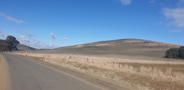
... tailing and abandoned mining relics associated with the former Union Mine occur on the margins of the lava flow. Mount Greenock is a 120 hectare ‘Geological Reserve’, is one of the few large scoria cones on public land and contains abundant outcrop and morphological evidence of its volcanic origin. Mt Greenock Mount Greenock mining mullock ...Mt Greenock is an extinct volcano with lava flows associated with a deep lead. It is a tall scoria cone with a broad shallow crater open to the northwest. In the crater are blocks and bombs of scoriaceous basalt. Long lava flows extend both north and south from the cone. It is considered a significant geological site, and part of the Major Mitchell Trail, with a 1936 ‘Centenary of Major Mitchell ‘monument on the summit. The flow to the north has been eroded by McCallum Creek which is a lateral stream. On the eastern base of the cone, the stream valley exposes a lava flow and underlying sedimentary rocks. The lava flow and the scoria cone overlie the Greenock lead (a buried valley with auriferous gravels). A line of mine tailing and abandoned mining relics associated with the former Union Mine occur on the margins of the lava flow. Mount Greenock is a 120 hectare ‘Geological Reserve’, is one of the few large scoria cones on public land and contains abundant outcrop and morphological evidence of its volcanic origin. Colour Photographs of Mt Greenock, near Talbot, Victoria. The photographs were taken in winter not long after the first post drought rains. Mt Greenock was climbed by Major Thomas Mitchell on 26 September 1936, and he gave it the current name. At that time the mount was part of Alexander McCallum's Dunach Forest Pastoral Run.mt greenock, mount greenock, mining, mullock heap, mt greenock geological reserve, union mine, volcanic grasslands, dunach -
 Ballarat Heritage Services
Photograph - Colour Photograph, Clare Gervasoni, Built Remains near Mount Greenock, 2025, 28/06/2025
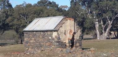
... tailing and abandoned mining relics associated with the former Union Mine occur on the margins of the lava flow. Mount Greenock is a 120 hectare ‘Geological Reserve’, is one of the few large scoria cones on public land and contains abundant outcrop and morphological evidence of its volcanic origin. Mt Greenock Mount Greenock mining mullock ...Mt Greenock is an extinct volcano with lava flows associated with a deep lead. It is a tall scoria cone with a broad shallow crater open to the northwest. In the crater are blocks and bombs of scoriaceous basalt. Long lava flows extend both north and south from the cone. It is considered a significant geological site, and part of the Major Mitchell Trail, with a 1936 ‘Centenary of Major Mitchell ‘monument on the summit. The flow to the north has been eroded by McCallum Creek which is a lateral stream. On the eastern base of the cone, the stream valley exposes a lava flow and underlying sedimentary rocks. The lava flow and the scoria cone overlie the Greenock lead (a buried valley with auriferous gravels). A line of mine tailing and abandoned mining relics associated with the former Union Mine occur on the margins of the lava flow. Mount Greenock is a 120 hectare ‘Geological Reserve’, is one of the few large scoria cones on public land and contains abundant outcrop and morphological evidence of its volcanic origin. Colour Photographs of bluestone and brick buildings at Mt Greenock, near Talbot, Victoria. The photographs were taken in winter not long after the first post drought rains. mt greenock, mount greenock, mining, mullock heap, mt greenock geological reserve, union mine, volcanic grasslands, dunach