Showing 19 items matching "muskerry"
-
 Bendigo Historical Society Inc.
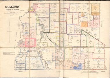
Map - MUSKERRY, No date visible
... MUSKERRY......Muskerry...Map: Parish of Muskerry. Parish plan (number 310 in map cupboard 1)...History House 11 Mackenzie Street Bendigo goldfields MAP parish plan Muskerry Map: Parish of Muskerry. Parish plan (number 310 in map cupboard 1) Map MUSKERRY ...Map: Parish of Muskerry. Parish plan (number 310 in map cupboard 1)map, parish plan, muskerry -
Bendigo Historical Society Inc.
Map - MUSKERRY, 23/01/1888
... MUSKERRY......Muskerry...Map: Muskerry , County of Rodney. Parish plan. ( number 251 in Map Cupboard 1)...History House 11 Mackenzie Street Bendigo goldfields MAP Rodney parish plan Muskerry Map: Muskerry , County of Rodney. Parish plan. ( number 251 in Map Cupboard 1) Map MUSKERRY ...Map: Muskerry , County of Rodney. Parish plan. ( number 251 in Map Cupboard 1)map, rodney, parish plan, muskerry -
Bendigo Historical Society Inc.
Map - MUSKERRY, 23/01/1888
... MUSKERRY......Muskerry...Map: Muskerry, County of Bendigo. Parish plan ( number 250 in Map Cupboard 1)...History House 11 Mackenzie Street Bendigo goldfields MAP Bendigo parish plan Muskerry Map: Muskerry, County of Bendigo. Parish plan ( number 250 in Map Cupboard 1) Map MUSKERRY ...Map: Muskerry, County of Bendigo. Parish plan ( number 250 in Map Cupboard 1)map, bendigo, parish plan, muskerry -
 Bendigo Historical Society Inc.
Map - JACK FLYNN COLLECTION: MUSKERRY, 1962
... ...Muskerry...Map: Parish of Muskerry, County of Rodney. Parish plan....Drawn and reproduced at the Department of Lands and Survey, Melbourne Map: Parish of Muskerry, County of Rodney. Parish plan. Map JACK FLYNN COLLECTION: MUSKERRY ...Map: Parish of Muskerry, County of Rodney. Parish plan.By Authority: A.C. Brooks, Government Printer, Melbourne. Drawn and reproduced at the Department of Lands and Survey, Melbournemap, rodney, parish plan, muskerry -
 Bendigo Historical Society Inc.
Newspaper - JENNY FOLEY COLLECTION: AT THE READY
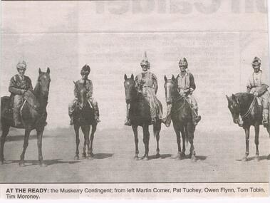
... Several contingencies existed in the Bendigo area from 1915. The Muskerry contingent consisted of 55 horses in 1915....At the ready: the Muskerry Contingent; from left: Martin Comer, Pat Tuohey, Owen Flynn, Tom Tobin, Tim Moroney. ...Several contingencies existed in the Bendigo area from 1915. The Muskerry contingent consisted of 55 horses in 1915. ...The Royal Irish Horse was an historical cavalry unit. In Australia it was ceremonial only and appears to have been closely related to St Patrick's Day processions and sports days. Several contingencies existed in the Bendigo area from 1915. The Muskerry contingent consisted of 55 horses in 1915.Bendigo Advertiser '' The way we were'' from 2002. At the ready: the Muskerry Contingent; from left: Martin Comer, Pat Tuohey, Owen Flynn, Tom Tobin, Tim Moroney. The clip is in a folder.newspaper, bendigo advertiser, the way we were -
Bendigo Historical Society Inc.
Map - MUSKERRY : COUNTY OF BENDIGO, 1962
... ...muskerry...Map. Muskerry, County of Bendigo, County of Rodney, Goornong, Ellesmere, Axedale, Weston, Crosbie, Toolleen, Campaspe, Forest or Mannering Creek, Back Creek, Campaspe River. ...(number 110 in map cupboard 1) Map MUSKERRY : COUNTY OF BENDIGO ...Map. Muskerry, County of Bendigo, County of Rodney, Goornong, Ellesmere, Axedale, Weston, Crosbie, Toolleen, Campaspe, Forest or Mannering Creek, Back Creek, Campaspe River. By authority A.C. Brooks, Government Printer, Melbourne. Drawn and reproduced at the Department of Lands and Survey, Melbourne, 1962. Price 2/-. (number 110 in map cupboard 1)A.C. Brooks, Government Printer, Melbourne.map, bendigo, muskerry -
 Bendigo Historical Society Inc.
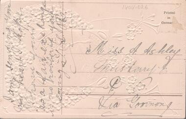
Postcard - MISS ASHLEY MUSKERRY EAST
... Postcard addressed to Miss Ashley Muskerry East....History House 11 Mackenzie Street Bendigo goldfields Postcard addressed to Miss Ashley Muskerry East. Postcard MISS ASHLEY MUSKERRY EAST ...Postcard addressed to Miss Ashley Muskerry East. -
 Bendigo Historical Society Inc.
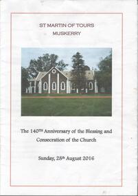
Document - CHURCHES OF BENDIGO COLLECTION: ST MARTIN OF TOURS - MUSKERRY
... Martin of Tours - Muskerry. The 140th Anniversary of the Blessing and Consecration of the Church. ...History House 11 Mackenzie Street Bendigo goldfields CHURCH History st martin of tours muskerry Twelve pages booklet titled St. Martin of Tours - Muskerry. ...Twelve pages booklet titled St. Martin of Tours - Muskerry. The 140th Anniversary of the Blessing and Consecration of the Church. Sunday, 28th August 2016church, history, st martin of tours muskerry -
Bendigo Historical Society Inc.
Newspaper - Bendigo Advertiser Collection: Schools Searching for a Future - Muskerry East Primary School 2108, August 20 1993
... This Article outlines the history, community role, and current challenges facing Muskerry East School, a rural Australian school. ...This Article outlines the history, community role, and current challenges facing Muskerry East School, a rural Australian school. ...This Article outlines the history, community role, and current challenges facing Muskerry East School, a rural Australian school. The school has existed on the same site since 1878, originally sharing a building with the Methodist church. The current weatherboard building was relocated in 1926 after the closure of Weston school. The school has experienced multiple closures due to low enrolment: from 1902–1922 and 1945–1951. Muskerry East is considered a true "neighborhood school" despite its remote location, with families like the Hicksons, Roulstons, Burkes, and Tuoheys attending for generations. The school serves as the central gathering place for the local farming community, especially for women who rely on school drop-offs and pick-ups for social interaction.It is now the only school remaining in a large area between Heathcote and Elmore, with others having closed. The Directorate of School Education is considering closing the school due to low enrolment (currently 15, projected 16–21), despite community guarantees of future students. Recent policy changes require at least 21 pupils for "non-remote" schools to remain open, putting Muskerry East at risk. The community feels the government has shifted requirements, making it harder for small schools to survive. Parents and community members are actively fighting to keep the school open, emphasizing its importance to local identity and cohesion.There is frustration that bureaucratic decisions may sever long-standing community ties and traditions. Muskerry East School stands as a symbol of rural resilience and community, now threatened by changing educational policies and declining rural populations.Schools searching for a Future. Series of photos and information about Muskeery East Primary School No. 2108. Pictures by Lisa Honeychurch. Written by Owen Davies. This item contains the following documents and Photos: 8091.604a Part of Page 11, the Bendigo Advertiser Friday August 20 1993 8091.604b Black and White Photo. Left to Right: Alma and Ron Hickson, Catherine Hamblin (attended 72 years ago), Beryl Roulston (husband was a student and both children attended the school), Joyce Moroney (student 69 years ago), Nancy Roulston, (Teacher) - Contact the BHS for details 8091.604c Black and White Photo. Left to Right: Beryl Roulston (husband was a student and both children attended the school), Joyce Moroney (student 69 years ago) - Contact the BHS for details 8091.604d Black and White Photo. Centenary Plaque (100 years of the school 9th Dec 1878 - Contact the BHS for details 8091.604e Black and White Photo. Joelene Morrissey (Grade 5) and Linda Hickson (Grade 4) - contact the BHS for details 8091.604f Black and White Photo. Ron Hickson (attended in 1927) and his grand children, L to R: Lauren Tuohey (Grade 4) Rowan Hickson (Grade 2) and Linda Hickson (Grade 5) - contact the BHS for details 8091.604g Black and White Photo. Catherine Hamblin (former pupil 72 years ago, when the school was in the old Methodist Church) - contact the BHS for details 8091.604h Black and White Photo. In the class room on the last day of school for the year 16 Dec 1993 - contact the BHS for details 8091.604i Black and White Photo. In front of the school, pupils, parents and community members - contact the BHS for detailsnewspaper, bendigo advertiser, primary school, muskerry east -
Bendigo Historical Society Inc.
Map - GOORNONG : COUNTY OF BENDIGO, September 1943
... Goornong, County of Bendigo, Egerton, Bagshot, Ellesmere, Muskerry, Campaspe, Nolan, Campaspe River, Town of Goornong. ...Goornong, County of Bendigo, Egerton, Bagshot, Ellesmere, Muskerry, Campaspe, Nolan, Campaspe River, Town of Goornong. ...Map. Goornong, County of Bendigo, Egerton, Bagshot, Ellesmere, Muskerry, Campaspe, Nolan, Campaspe River, Town of Goornong. By authority : H.E. Daw, Government Printer, Melbourne. Drawn and reproduced at the Department of Lands and Survey, Melbourne, Victoria. September 1943, Price 2/-. (number 44 in map cupboard 1)H.E. Daw, Government Printer, Melbourne.map, bendigo, goornong -
Bendigo Historical Society Inc.
Map - TOOLLEEN : COUNTY OF BENDIGO, 25-5-26
... Toolleen, County of Bendigo, County of Rodney, Campaspe, Colbinabbin, Cornella, Crosbie, Muskerry, Mount Pleasant Creek, Township of Toolleen. ...Toolleen, County of Bendigo, County of Rodney, Campaspe, Colbinabbin, Cornella, Crosbie, Muskerry, Mount Pleasant Creek, Township of Toolleen. ...Map. Toolleen, County of Bendigo, County of Rodney, Campaspe, Colbinabbin, Cornella, Crosbie, Muskerry, Mount Pleasant Creek, Township of Toolleen. By authority H.J. Green, Govt. Printer. Photo-Lithographed at the Department of Lands and Survey, Melbourne by W.J. Butson, 25-5-26. (number 106 in map cupboard 1)H.J. Green, Govt. Printermap, bendigo, toolleen -
Bendigo Historical Society Inc.
Map - TOOLLEEN : COUNTY OF BENDIGO, 25-5-26
... Toolleen, County of Bendigo, County of Rodney, Campaspe, Colbinabbin, Cornella, Crosbie, Muskerry, Mount Pleasant Creek, Township of Toolleen. ...Toolleen, County of Bendigo, County of Rodney, Campaspe, Colbinabbin, Cornella, Crosbie, Muskerry, Mount Pleasant Creek, Township of Toolleen. ...Map. Toolleen, County of Bendigo, County of Rodney, Campaspe, Colbinabbin, Cornella, Crosbie, Muskerry, Mount Pleasant Creek, Township of Toolleen. By authority H.J. Green, Govt. Printer. Photo-Lithographed at the Department of Lands and Survey, Melbourne by W.J. Butson, 25-5-26. (number 105 in map cupboard 1)H.J. Green, Govt. Printer.map, bendigo, toolleen -
Bendigo Historical Society Inc.
Map - ELLESMERE, COUNTY BENDIGO, 17-3-16
... Map, Ellesmere, County Bendigo, Goornong, Bagshot, Muskerry, Wellsford, Axedale, Township of Fosterville.Campaspe River, Bendigo Creek, Railway Line.Photographed at the Dept. of Lands and Survey, Melbourne by W.J.Butson 17-3-16.Price 1/-. ...Map, Ellesmere, County Bendigo, Goornong, Bagshot, Muskerry, Wellsford, Axedale, Township of Fosterville.Campaspe River, Bendigo Creek, Railway Line.Photographed at the Dept. of Lands and Survey, Melbourne by W.J.Butson 17-3-16.Price 1/-. ...Map, Ellesmere, County Bendigo, Goornong, Bagshot, Muskerry, Wellsford, Axedale, Township of Fosterville.Campaspe River, Bendigo Creek, Railway Line.Photographed at the Dept. of Lands and Survey, Melbourne by W.J.Butson 17-3-16.Price 1/-. By authority Albert J.Mullett, Government Printer, Melbourne. ( number 38 in Map Cupboard 1)Albert J.Mullett, Govt. Printer, Melbourne.map, bendigo, ellesmere -
Bendigo Historical Society Inc.
Map - WESTON : COUNTY OF BENDIGO : COUNTY OF RODNEY, 4-5-21
... Weston, County of Bendigo, County of Rodney, Muskerry, Crosbie, Knowsley East, Knowsley, Axedale. ...Weston, County of Bendigo, County of Rodney, Muskerry, Crosbie, Knowsley East, Knowsley, Axedale. ...Map. Weston, County of Bendigo, County of Rodney, Muskerry, Crosbie, Knowsley East, Knowsley, Axedale. Back Creek. By authority A.J. Mullett, Government Printer, Melbourne. Photo-Lithographed at the Department of Lands and Survey, Melbourne by W.J. Butson 4-5-21. Price 1/-. (number 108 in map cupboard 1)A.J. Mullett, Government Printer, Melbourne.map, bendigo, weston -
Bendigo Historical Society Inc.
Map - CAMPASPE : COUNTY OF BENDIGO, 1964
... Campaspe, County of Bendigo, County of Rodney, Runnymede, Nolan, Muskerry, Toolleen, Colbinabbin, Campaspe River, Goornong, Mount Pleasant Creek. ...Campaspe, County of Bendigo, County of Rodney, Runnymede, Nolan, Muskerry, Toolleen, Colbinabbin, Campaspe River, Goornong, Mount Pleasant Creek. ...Map. Campaspe, County of Bendigo, County of Rodney, Runnymede, Nolan, Muskerry, Toolleen, Colbinabbin, Campaspe River, Goornong, Mount Pleasant Creek. By authority A.C. Brooks, Government Printer, Melbourne. Drawn and reproduced at the Department of Lands and Survey, Melbourne. 1964. Price 10/- per sheet. (number 112 in map cupboard 1)A.C. Brooks, Government Printer, Melbourne.map, bendigo, campaspe -
Bendigo Historical Society Inc.
Map - GOORNONG : COUNTY OF BENDIGO, 27-10-25
... Town of Goornong, Northern Railway. Campaspe, Muskerry, Campaspe River. Photo-Lithographed at the Department of Lands and Survey, Melbourne by W.J. ...Town of Goornong, Northern Railway. Campaspe, Muskerry, Campaspe River. Photo-Lithographed at the Department of Lands and Survey, Melbourne by W.J. ...Map. Goornong, County of Bendigo, Egerton, Nolan, Ellesmere, Bagshot. Town of Goornong, Northern Railway. Campaspe, Muskerry, Campaspe River. Photo-Lithographed at the Department of Lands and Survey, Melbourne by W.J. Butson, 27-10-25,Price 1/-. By authority: H.J. Green, Government Printer, Melbourne. (number 43 in map cupboard 1)H.J. Green,Govt.Printer, Melbourne.map, bendigo, goornong -
Bendigo Historical Society Inc.
Map - ELLESMERE : COUNTY OF BENDIGO, 18-1-1943
... Ellesmere, County Bendigo, Bagshot, Wellsford, Axedale, Muskerry, Goornong, Bendigo Creek, Bendigo to Echuca- Northern Railway Line, Campaspe River, Sugarloaf Trig.Station. ...Ellesmere, County Bendigo, Bagshot, Wellsford, Axedale, Muskerry, Goornong, Bendigo Creek, Bendigo to Echuca- Northern Railway Line, Campaspe River, Sugarloaf Trig.Station. ...Map. Ellesmere, County Bendigo, Bagshot, Wellsford, Axedale, Muskerry, Goornong, Bendigo Creek, Bendigo to Echuca- Northern Railway Line, Campaspe River, Sugarloaf Trig.Station. Township of Fosterville.By Authority: H.E. Daw, Govt. Printer, Melbourne. Drawn ad reproduced at the Dept. of Lands and Survey, Melbourne . 18-1-1943.Price 2/-. (number 37 in map cupboard 1)H.E. Daw, Government Printer, Melbourne.map, bendigo, ellesmere -
Bendigo Historical Society Inc.
Map - AXEDALE, COUNTIES OF BENDIGO & RODNEY, 8-2-26
... Map, Axedale, Counties of Bendigo & Rodney, Wellsford, Strathfieldsaye, Eppalock, Knowsley, Weston, Muskerry, Ellesmere, Town of Axedale, Longlea Railway Station, Axedale Railway Station, Wallan & Bendigo Railway. ...Map, Axedale, Counties of Bendigo & Rodney, Wellsford, Strathfieldsaye, Eppalock, Knowsley, Weston, Muskerry, Ellesmere, Town of Axedale, Longlea Railway Station, Axedale Railway Station, Wallan & Bendigo Railway. ...Map, Axedale, Counties of Bendigo & Rodney, Wellsford, Strathfieldsaye, Eppalock, Knowsley, Weston, Muskerry, Ellesmere, Town of Axedale, Longlea Railway Station, Axedale Railway Station, Wallan & Bendigo Railway. Campaspe River.Axe Creek. By authority H.J.Green, Govt. Printer. Photo-Lithographed at the Dept. of Lands and Survey, Melbourneby W.J.Butson 8-2-26. Price 1/-. (number 60 in map cupboard 1)H.J.Green, Govt. Printer.map, bendigo, axedale -
 Bendigo Historical Society Inc.
Document - BARNADOWN RUN: SHORT PAPER JOHN HARNEY
... The original Barnedown Run consisted of 51,280 acres and was first taken up in 1839 by Henry Grey Bennett and was held under "Pre-emptive right" until it was subdivided in 1856 into Muskerry and Mt. Pleasant. In 1853 John Harney arrived in Australia and took up storekeeping at White Hills. ...Basrnadown Run John Harney The original Barnedown Run consisted of 51,280 acres and was first taken up in 1839 by Henry Grey Bennett and was held under "Pre-emptive right" until it was subdivided in 1856 into Muskerry and Mt. Pleasant. In 1853 John Harney arrived in Australia and took up storekeeping at White Hills. ...The original Barnedown Run consisted of 51,280 acres and was first taken up in 1839 by Henry Grey Bennett and was held under "Pre-emptive right" until it was subdivided in 1856 into Muskerry and Mt. Pleasant. In 1853 John Harney arrived in Australia and took up storekeeping at White Hills. In 1855 he took up land which was originally part of Barnadown Run and erected part of the present homestead. In 1860 Harney entertained Burke and Wills exploration party at Adelaide Vale on the Campaspe River. Mr Harney owned a Hotel which was burnt down in 1861. Henry Grey Bennett a generous man died in1871 and the citizens of Bendigo erected a 20ft monument over his grave.John Harneyjohn harney, john harney, henry grey bennett, pre-emptive rights, white hills, adelaide vale, bourke and wills, edward o'keefe, cecil hyatt, mr frank k. hill., basrnadown run