Showing 3 items matching "narre worran"
-
 Federation University Historical Collection
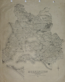
Plan, Mornington, 1926, 1926
... ...narre worran...Barker Library (top floor) Mount Helen goldfields mornington phillip island western port bay bass straight wonthaggi lang lang sherwood nepean narre worran ringwood Printed plan on paper Mornington, 1926 Plan Plan F.W. ...Printed plan on papermornington, phillip island, western port bay, bass straight, wonthaggi, lang lang, sherwood, nepean, narre worran, ringwood -
 Southern Sherbrooke Historical Society Inc.
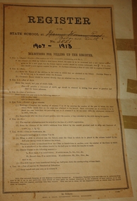
Register, school
... ...narre worran east...Southern Sherbrooke Historical Society Inc. 127 Colby Drive Belgrave Heights 3160 yarra-valley-and-the-dandenong-ranges Passed on to the society by Belgrave South State School belgrave south state school narre warren north-east narre worran east school pupils sophie giles On cover, "Narree Worran East" ruled through and "Belgrave South" written below; "3551", all in ink. "1907-1913" in heavy black ink. ...Passed on to the society by Belgrave South State SchoolA pre-printed booklet, comprising 6 pages. Cover has instruction sheet glued on. Pupils' details filled in by hand in ink. Was previously stapled but staples are missing.On cover, "Narree Worran East" ruled through and "Belgrave South" written below; "3551", all in ink. "1907-1913" in heavy black ink. "A.D. 30.4.09" written in ink on top left corner of second page.belgrave south state school, narre warren north-east, narre worran east, school pupils, sophie giles -
 Southern Sherbrooke Historical Society Inc.
Map - photocopy
... A3 photocopy of plan of survey of part of Crown Allotments 20 & 21, section C, parish of Narre Worran, County of Mornington. Clements Ave and environs in Belgrave Heights...A3 photocopy of plan of survey of part of Crown Allotments 20 & 21, section C, parish of Narre Worran, County of Mornington. Clements Ave and environs in Belgrave Heights Map - photocopy ...A photocopy taken from the original land sale map provided to the society through Karel Coxell of Stockdale & Leggo. The original maps are stored in large bound account books and were originally the propert of McNally Real Estate. The books are held (in 2A3 photocopy of plan of survey of part of Crown Allotments 20 & 21, section C, parish of Narre Worran, County of Mornington. Clements Ave and environs in Belgrave Heights"Villette Estate" in top LH corner, "Locality Plan" in bottom LH corner, "Not in sale" written on one block and crossed out. All handwritten in pencil on original. "Colby Drive " and "Verona Street" added in pencil to copy.land sales, advertisements, subdivision