Showing 64 items matching "native vegetation"
-
 Eltham District Historical Society Inc
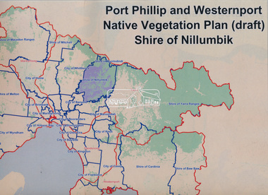
Book, Port Phillip and Westernport Native Vegetation Plan (draft), Shire of Nillumbik
... Port Phillip and Westernport Native Vegetation Plan (draft), Shire of Nillumbik...Eltham District Historical Society Inc 728 Main Rd Eltham melbourne Entire report available www.ppwema.vic.gov.au A3 spiral bound, 29 maps Port Phillip and Westernport Native Vegetation Plan (draft), Shire of Nillumbik Book Book ...Entire report available www.ppwema.vic.gov.au -
 Save the Dandenongs League Inc.
Archive (item), Save the Dandenongs League Incorporated, Re: Recent Clearing of Native Vegetation and Soil Disturbance at Forest Part Estate Upwey
... Re: Recent Clearing of Native Vegetation and Soil Disturbance at Forest Part Estate Upwey...Re: Recent Clearing of Native Vegetation and Soil Disturbance at Forest Part Estate Upwey Archive Save the Dandenongs League Incorporated ... -
University of Melbourne, Burnley Campus Archives
Document, A.E Wilkie, Utilization of native vegetation, 1956
... Utilization of native vegetation...Wilkie to BHCPSA Utilization of native vegetation Document A.E Wilkie ...Notes for lecture by A.E. Wilkie to BHCPSAa.e. wilkie, students, nurseryman, 1947, bhcpsa -
 Victorian Farmers Federation
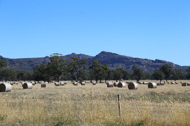
Photograph, Lisa Gervasoni, Hay bales in the Grampians Region, 27/01/2017
... ...native vegetation...The paddock shows the co-existence of native vegetation which provides cover for livestock. ...The paddock shows the co-existence of native vegetation which provides cover for livestock. farming hay native vegetation agriculture farm Western Victoria Digital photograph Hay bales in the Grampians Region Photograph Lisa Gervasoni ...Hay bales are a key food in a grazing livestock production system. The paddock shows the co-existence of native vegetation which provides cover for livestock. Digital photographfarming, hay, native vegetation, agriculture, farm, western victoria -
Whitehorse Historical Society Inc.
Pamphlet, Eastern freeway extension, 1/02/2000 12:00:00 AM
... Supplement no 13 : mapping of trees and native vegetation within the Deep Creek Road realignment [by] Botanicus Australia Pty Ltd for VicRoads....Supplement no 13 : mapping of trees and native vegetation within the Deep Creek Road realignment [by] Botanicus Australia Pty Ltd for VicRoads....Whitehorse Historical Society Inc. 2-10 Deep Creek Road Mitcham melbourne Supplement no 13 : mapping of trees and native vegetation within the Deep Creek Road realignment [by] Botanicus Australia Pty Ltd for VicRoads. ...Eastern Freeway extension Between Springvale Road and Ringwood: flora and fauna assessment.Eastern Freeway extension Between Springvale Road and Ringwood: flora and fauna assessment. Supplement no 13 : mapping of trees and native vegetation within the Deep Creek Road realignment [by] Botanicus Australia Pty Ltd for VicRoads.Eastern Freeway extension Between Springvale Road and Ringwood: flora and fauna assessment. eastern freeway extension, native plants, wild life, vicroads, deep creek road, mitcham -
 Camperdown & District Historical Society
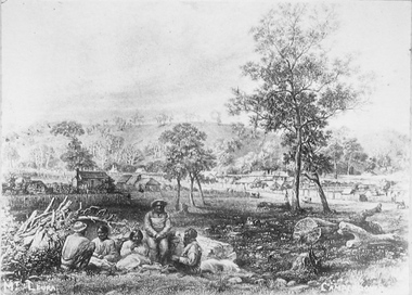
Photograph - Etching of early Camperdown scene, Mt Leura Camperdown, c1850s
... This etching was created of Camperdown c1850s showing a group of First Nations people and early dwellings and native vegetation around Mounts Leura and Sugarloaf. ...Etching of early Camperdown scene showing group of First Nations people in the foreground with early buildings, native vegetation and Mount Leura and Mount Sugarloaf in the background. ...Camperdown & District Historical Society 241 Manifold St Camperdown great-ocean-road This etching was created of Camperdown c1850s showing a group of First Nations people and early dwellings and native vegetation around Mounts Leura and Sugarloaf. ...This etching was created of Camperdown c1850s showing a group of First Nations people and early dwellings and native vegetation around Mounts Leura and Sugarloaf. Camperdown was surveyed by Robert Dunbar Scott in 1851. First dwelling constructed by David Fenton in 1853 on site of Commercial Hotel. Etching of early Camperdown scene showing group of First Nations people in the foreground with early buildings, native vegetation and Mount Leura and Mount Sugarloaf in the background. On front: Mt Leura, Camperdowncdhs, djargurd wurrung, djargurdwurrung, mount leura, mt leura, mount sugarloaf, mt sugarloaf, cdhsfirstnations -
 Federation University Historical Collection
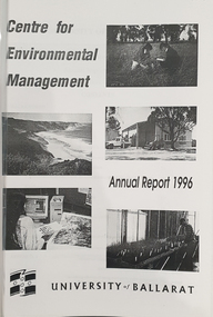
Booklet, University of Ballarat Centre for Environmental Management, 1996
... ...native vegetation assessment...The University will be working with the lessees to develop the historic Telegraph Station as a dual purpose facility for interpretation and research." university of ballarat centre for environmental management martin westbrooke richard mcewan mal weston john miller nanya telegraph station, cape otway cape otway lighthouse station cape otway telegraph station field resaerch stations s. hadden peter dahlhaus r.j. macewan pat prevett native vegetation assessment fauna management pest plants and animal research soil and water assessment conservation reserve management paul ryan richard macewan Black and white cover with clear plastic sheet. ...The Centre for Environmental Management as established in July 1995 as a strategic development initiative to consolidate the University's position as a centre for industry linked environmenttal teaching, resarech and consultancy. Page 19 "SPECIAL INITIATIVES Establishment of field Research Stations Two areas of concentration of research effort for the Centre are the Otways in the south western Victoria and the Scotia Country in the rangelands of NSW. In both these areas it is essential that ther be a secure accomodation abase for research students. In the former case there is a need for a sheltered base to enable year round field work in cold wet conditions and in the latter a base with a reliable water supply and the facilities to allow field work in very hot dry conditions which prevail from much of the year. It has been an ibjective of the Centre to establish field stations at these two sites and considerable progress has been made through the year. (i) Nanya Field Station in the Scotial Country Through the generosity of the owner, Mr Rob Taylor, an unused homestead on Nanya Station was made available to the Centre. Largely through voluntary labour during research field trips during the year this previously derelict homestead has been restored to functionality and now has facilities for up to 20 research workers with a reliable water supply, cooking, washing, and refrigeration facilities. (ii) Cape Otway Resaerch Centre Negotiations have continued through the year with the potential lessees of the Cape Otway Lighthouse Precinct with the support of the Vice Chancellor and other potential user groups within the University these have reached a successful outcome. The University will be working with the lessees to develop the historic Telegraph Station as a dual purpose facility for interpretation and research." Black and white cover with clear plastic sheet. university of ballarat, centre for environmental management, martin westbrooke, richard mcewan, mal weston, john miller, nanya, telegraph station, cape otway, cape otway lighthouse station, cape otway telegraph station, field resaerch stations, s. hadden, peter dahlhaus, r.j. macewan, pat prevett, native vegetation assessment, fauna management, pest plants and animal research, soil and water assessment, conservation reserve management, paul ryan, richard macewan -
 Sunbury Family History and Heritage Society Inc.
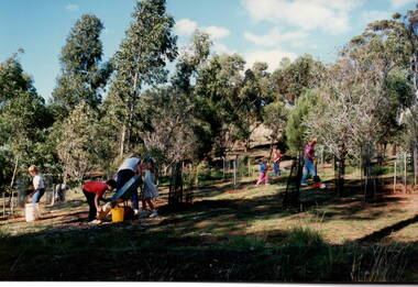
Photograph, Arbor Week celebration, April 26th - 29th 1989
... ...Native vegetation...Arbor Week Bulla Primary School Gardening Native vegetation A non-digital coloured photograph of six children and an adult doing gardening in a bushland setting. ...The students attending Bulla Primary School celebrated Arbor Week in 1989 by improving the school garden and planting native trees on the surrounding area adjacent to the school.The experience gave the children an awareness of the importance of trees and an understanding of the local native flora.A non-digital coloured photograph of six children and an adult doing gardening in a bushland setting.arbor week, bulla primary school, gardening, native vegetation -
 Sunbury Family History and Heritage Society Inc.
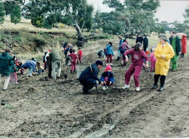
Photograph, Tree planting, 1987
... ...Native vegetation...They were planting trees that were native to the area in a bid to replenish the parkland with natural vegetation....The excursion aimed to give the students an awareness of the native vegetation in the area and the importance of conserving natural growth areas. ...The students from Bulla Primary School were taken on a school excursion to nearby Woodlands Park where they took part in a tree planting activity. They were planting trees that were native to the area in a bid to replenish the parkland with natural vegetation.The excursion aimed to give the students an awareness of the native vegetation in the area and the importance of conserving natural growth areas. A non-digital photograph of a group of children planting young trees in a prepared area in parkland while being supervised by a number of adults tree planting, woodlands park, bulla primary school, native vegetation -
 Orbost & District Historical Society
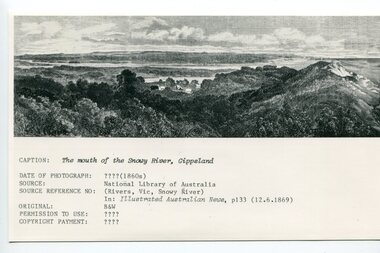
Photograph - Mouth of the Snowy River 1869, 1860s
... A b/w photo of a drawing/painting/photo of a scene showing a small collection of huts set amongst native vegetation, with hummocks water, and ocean in the background. ...A b/w photo of a drawing/painting/photo of a scene showing a small collection of huts set amongst native vegetation, with hummocks water, and ocean in the background. ...This is a photo of a print produced on p133 of the 12.6.1869 issue of the Illustrated Australian News. It appears to have been sourced because it represents one of the earliest known representations of the Snowy River mouth. An early settlement near the mouth of the Snowy is shown here by a small clutch of huts. Later, the township of Marlo developed in this location, along with the township of Orbost upstream on the Snowy River. Significantly, the mouth of the Snowy River as shown in this image appears to be represented in the back right-hand corner of the image. This photograph is significant because it is shows one of the earliest representations of the mouth of the Snowy River (1960s). It shows the location of the mouth as being quite different from its location now (2026).A b/w photo of a drawing/painting/photo of a scene showing a small collection of huts set amongst native vegetation, with hummocks water, and ocean in the background. Below the photo are a number of lines of black print. CAPTION: The mouth of the Snowy River, Gippsland DATE OF PHOTOGRAPH: ???? (1860S) SOURCE: National Library of Australia SOURCE REFERENCE No.: (Rivers, Vic, Snowy River) In Illustrated Australian News p133 (12.6.1869) ORIGINAL: b/w PERMISSION TO USE: ???? COPYRIGHT PAYMENT: ?????snowy river, snowy river mouth -
Ballarat Heritage Services
Book, Hepburn Shire Council Biodiversity strategy, 2018, 2018
... Hepburn Shire has approximately 67,275 hectares of native vegetation, or 46 percent of the shire. ...Ballarat Heritage Services PO Box 2209 Bakery Hill Post Office goldfields Hepburn Shire has approximately 67,275 hectares of native vegetation, or 46 percent of the shire. Biodiversity Shire of Hepburn Ricky Nelson Dja Dja Wurrung public land management Climate Change Habitat Corridors Biolink zones weed management 48 Page report on biodiversity in the Victorian Shire of Hepburn. ...48 Page report on biodiversity in the Victorian Shire of Hepburn. non-fictionbiodiversity, shire of hepburn, ricky nelson, dja dja wurrung, public land management, climate change, habitat corridors, biolink zones, weed management -
 Croydon Conservation Society Inc.
Document, Town Park (South) - submission to Council re land use - date unknown
... CCS view of land capabilities, native vegetation and current use and future use of Town Park South area...Croydon melbourne CCS view of land capabilities, native vegetation and current use and future use of Town Park South area One typed page of submission paper to Council. ...CCS view of land capabilities, native vegetation and current use and future use of Town Park South areaOne typed page of submission paper to Council. -
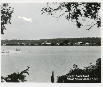 Lakes Entrance Historical Society
Postcard, 1945c
... The view shows a glimpse of the beach known formerly as Play Point, the picture framed by native vegetation. Lakes Entrance Victoria...The view shows a glimpse of the beach known formerly as Play Point, the picture framed by native vegetation. Lakes Entrance Victoria Postcard ...Black and white small format postcard showing a distant view of the town, taken from the southern shore of the lake. The view shows a glimpse of the beach known formerly as Play Point, the picture framed by native vegetation. Lakes Entrance VictoriaLakes Entrance from front beach armtownship, waterfront -
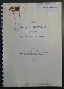 Stawell Historical Society Inc
Book - Report, The Remnant Vegetation of the Shire of Stawell, 1990
... Study of what remains of Native Vegetation towards conserving what remains on Public and Private land as well as revegetation through shire...Study of what remains of Native Vegetation towards conserving what remains on Public and Private land as well as revegetation through shire The Remnant Vegetation of the Shire of Stawell by John Miller. ...Study of what remains of Native Vegetation towards conserving what remains on Public and Private land as well as revegetation through shireBound PaperThe Remnant Vegetation of the Shire of Stawell by John Miller. School of Biological and Chemical Sciences Ballarat University Collage -
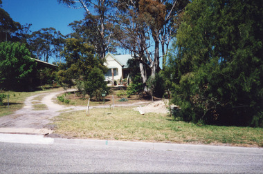 Lakes Entrance Historical Society
Photograph - Housing, Holding M, 6 Worcester Street, Lakes Entrance Victoria, 1999
... Steps leading up to veranda. Set in native vegetation, at 6 Worcester Street, Lakes Entrance Victoria...Steps leading up to veranda. Set in native vegetation, at 6 Worcester Street, Lakes Entrance Victoria 6 Worcester Street, Lakes Entrance Victoria Photograph Housing Holding M ...Appears to have been relocated from unknown site, more research required.Colour photograph of a timber dwelling. Has high pitched corrugated iron roof, decorative timber frieze under pitch of gable over front room. Steps leading up to veranda. Set in native vegetation, at 6 Worcester Street, Lakes Entrance Victoriaaccommodation, houses, heritage study -
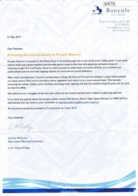 Greensborough Historical Society
Letter, Restoring the natural beauty at Pioneer Reserve, 21/05/2019
... Letter to residents, outlining plans to renovate Pioneer Reserve Greensborough by introducing native vegetation and returning it to a more natural state. ...Greensborough Historical Society 34A Glenauburn Road Lower Plenty Lower Plenty melbourne Letter to residents, outlining plans to renovate Pioneer Reserve Greensborough by introducing native vegetation and returning it to a more natural state. ...Letter to residents, outlining plans to renovate Pioneer Reserve Greensborough by introducing native vegetation and returning it to a more natural state. This includes removing the toilets, picnic shelter and playground.2 p. letter, coloured aerial photograph on back pagepioneer reserve greensborough, banyule council -
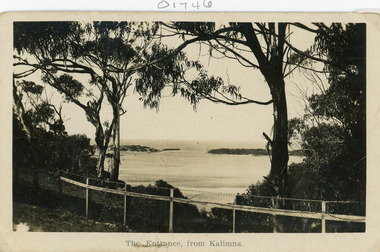 Lakes Entrance Historical Society
Postcard - The Entrance
... In the foreground native vegetation on the cliff top behind simple timber and wire netting boundary fence topped with a single strand of barbed wire. ...In the foreground native vegetation on the cliff top behind simple timber and wire netting boundary fence topped with a single strand of barbed wire. ...Black and white postcard of the man made entrance through the sand hummocks, taken from Kalimna cliff top. In the foreground native vegetation on the cliff top behind simple timber and wire netting boundary fence topped with a single strand of barbed wire. Lakes Entrance VictoriaThe Entrance from Kalimnawaterways, topography, islands -
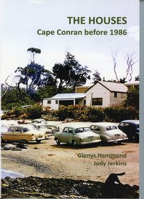 Orbost & District Historical Society
Book - THE HOUSES Cape Conran before 1986, Glenys Hammond and Judy Jenkins, THE HOUSES Cape Conran before 1986. Written by Glenys Hammond and Judy Jerkins, 2025
... Front cover has a coloured photo of a house surrounded by native vegetation in a beach setting. ln front of the house are cars on the beach. ...Front cover has a coloured photo of a house surrounded by native vegetation in a beach setting. ln front of the house are cars on the beach. ...Written in 2025, this book tells the story of a settlement at Cape Conran from early 20th Century until 1986. Cape Conran is on the coast of East Gippsland, Victoria. This book contains memories and photographs and diagrams and letters of the settlement. These were mainly holiday houses and occupied beachfront land by way of permissive occupancies (leases). In the 1980s, the occupants were asked by the Victorian Government to relinquish these leases and demolish the houses. The land then became part of a Coastal Park.This book is significant because it is a history of a beach settlement of holiday houses at Cape Conran from 1900-1986.Book of 152 pages. Front cover has a coloured photo of a house surrounded by native vegetation in a beach setting. ln front of the house are cars on the beach. Back cover has a coloured photo of houses, with cars and people on the beach in front of the houses. The background is smokey, possibly from a bushfire.on front cover: THE HOUSES Cape Conran before 1986. Glenys Hammond Judy Jenkinsglenys hammond, judy jenkins, cape conran coastal park, holiday houses, cape conran -
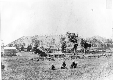 Camperdown & District Historical Society
Photograph - Aboriginal people at Mt Leura, Camperdown, c1875
... This image also shows early primitive dwellings, Ower's flour mill (built 1868) and surviving native vegetation. ...This image also shows early primitive dwellings, Ower's flour mill (built 1868) and surviving native vegetation. CDHS Djargurdwurrung Wombeetch Puyuun Camperdown George Prince Charlie Mount Leura Mount Sugarloaf Mt Sugarloaf Ower's Mill CDHSFirstNations On back: Early 1870s, Bought at first land sale Cr Scott & Curdie St, F.H. ...Three Djargurd Wurrung people on Country, pictured in front of Mt Leura, Camperdown c1875. This image also shows early primitive dwellings, Ower's flour mill (built 1868) and surviving native vegetation. Image of three Djargurd Wurrung people seated in front of Mt Leura, Camperdown, taken near corner of Scott and Curdie Streets c1875. On back: Early 1870s, Bought at first land sale Cr Scott & Curdie St, F.H. Grant, 11 Adeney Streetcdhs, djargurdwurrung, wombeetch puyuun, camperdown george, prince charlie, mount leura, mount sugarloaf, mt sugarloaf, ower's mill, cdhsfirstnations -
 Bendigo Historical Society Inc.
Document - PETER ELLIS COLLECTION: INFORMATION ON THE BARFOLD GORGE
... There is a description of the Gorge. Native vegetation growing there is also mentioned. ...There is a description of the Gorge. Native vegetation growing there is also mentioned. ...Foolscap page of information on the Barfold Gorge, by Frank Robbins. Barfold Gorge is compared with the Sydenham Organ Pipes National Park. There is a description of the Gorge. Native vegetation growing there is also mentioned. Turning it into a National Park is mentioned but it is in private ownership and this would require buy back of the land and create access problems as it is a farming area.place, land, barfold gorge, peter ellis collection, barfold gorge, sydenham organ pipes national park, campaspe river, mitchell's falls, queen's falls, piper's creek, turpin's falls, land conservation council, victoria conservation trust, frank robbins -
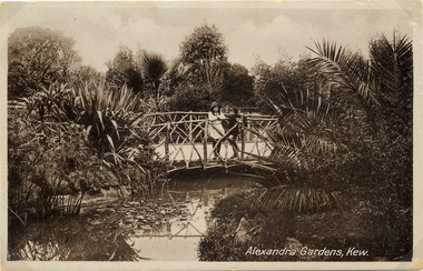 Kew Historical Society Inc
Postcard, Alexandra Gardens, Kew, 1910-1920
... On the evidence of this postcard, planting within the Gardens included a range of exotic specimens including a variegated aloe and water lilies. Native vegetation can be seen in the distance....On the evidence of this postcard, planting within the Gardens included a range of exotic specimens including a variegated aloe and water lilies. Native vegetation can be seen in the distance. Alexandra Gardens, Kew Postcard Postcard ...Named after Queen Alexandra, these beautiful gardens opened in 1908 and are designed in the formal style typical of the early 1900s.Early postcard showing architectural features and original plantings.The Alexandra Gardens, Cotham Road Kew. The postcard depicts a pedestrian bridge within the Gardens. The bridge, on which are standing two children, has rustic sides. On the evidence of this postcard, planting within the Gardens included a range of exotic specimens including a variegated aloe and water lilies. Native vegetation can be seen in the distance.alexandra gardens - kew (vic), postcards -- kew (vic.) -
 Kew Historical Society Inc
Postcard, Alexandra Gardens, Kew, 1908-1918
... On the evidence of this postcard, planting within the Gardens included a range of exotic specimens including a variegated aloe and water lilies. Native vegetation can be seen in the distance....On the evidence of this postcard, planting within the Gardens included a range of exotic specimens including a variegated aloe and water lilies. Native vegetation can be seen in the distance. Alexandra Gardens, Kew Postcard Postcard ...Named after Queen Alexandra, these beautiful gardens opened in 1908 and are designed in the formal style typical of the early 1900s.Early postcard showing original architectural features and plantings.The Alexandra Gardens, Cotham Road Kew. The postcard depicts a pedestrian bridge within the Gardens. The bridge, on which are standing two children, has rustic sides. On the evidence of this postcard, planting within the Gardens included a range of exotic specimens including a variegated aloe and water lilies. Native vegetation can be seen in the distance.alexandra gardens - kew (vic), postcards -- kew (vic.) -
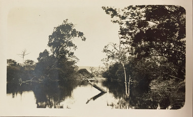 Kew Historical Society Inc
Photograph - Yarra River, Kew, 1924
... The image is of the Yarra at Kew, looking upstream with native vegetation on either bank. There is a wooden fence on the left bank....The image is of the Yarra at Kew, looking upstream with native vegetation on either bank. There is a wooden fence on the left bank. ...Henry Beater Christian (1886-1962) , was a descendant of one of the earliest settler families in Kew. Employed at the Kew Asylum as a 'public servant', he was a skilled amateur photographer, photographing numerous scenes in Kew and on his travels around Victoria. The majority of his photographs date from 1916 to 1929. His finest photographs are housed in two photograph albums. A dated early photograph of the Yarra River at Kew.Digital copy of a photograph from page 1 of the 47-page photograph album containing 261 gelatinous silver images, loaned by Diane Washfold with permission given to digitise and hold a copy in our collection. The image is of the Yarra at Kew, looking upstream with native vegetation on either bank. There is a wooden fence on the left bank."Yarra River Kew 1924"henry beater christian (1886-1962), landscape photography, kew (vic.) — yarra river, christian-washfold collection, photograph albums -
 The Beechworth Burke Museum
Photograph - Stereoscopic Photograph
... It captures the gorge and native vegetation in the foreground, with the Beechworth township visible in the middle, where the hospital is marked with an arrow. ...It captures the gorge and native vegetation in the foreground, with the Beechworth township visible in the middle, where the hospital is marked with an arrow. ...This photograph offers a view of Beechworth, located at the foot of the Victorian Alps. It captures the gorge and native vegetation in the foreground, with the Beechworth township visible in the middle, where the hospital is marked with an arrow. Distant hills form the backdrop. Originally settled c1839, Beechworth was officially proclaimed a town in 1856.This photograph is historically significant as it captures the landscape of Beechworth, providing valuable insight into the town's visual and historical character.Two sepia-toned square photographs showing the view of a town with trees in the foreground and hills in the far distance, mounted.Obervse: Above the right photograph there is an arrow pointing down. Reverse: 97.2195/ View across the Gorge/ looking over Beechworth/ (Hospital under arrow)/ 84-110-1/ A03082beechworth, town, landscape, ovens district, stereoscopic -
Croydon Conservation Society Inc.
Archive, Ringwood Lake Park - Archive Collection - Parent Record
... 3.5 hectares of remnant native vegetation are managed for conservation at Ringwood Lake Park. ...Croydon melbourne 3.5 hectares of remnant native vegetation are managed for conservation at Ringwood Lake Park. ...3.5 hectares of remnant native vegetation are managed for conservation at Ringwood Lake Park. Several locally rare plant species persist in the reserve, one of which occurs nowhere else in Maroondah. The site provides important habitat for many waterbirds, as well as small marsupials, lizards, bats and invertebrates. -
 Lakes Entrance Historical Society
Photograph - North Arm. Lakes Entrance Victoria c1908
... In foreground gravel road, and post and rail fence and native vegetation. Telegraph poles on either side of North Arm. ...In foreground gravel road, and post and rail fence and native vegetation. Telegraph poles on either side of North Arm. ...Sepia tone and Tinted photograph of wooden bridge across North Arm, showing a distant view of the town, Cunninghame Arm and sand hummocks, and a view of the North Arm, small wooden bridge connecting to mud island. In foreground gravel road, and post and rail fence and native vegetation. Telegraph poles on either side of North Arm. Photo mounted on heavy card. Lakes Entrance Victoria. Also 1x Black and white print of same Cunninghame A Cooperbridges, roads and streets, fences -
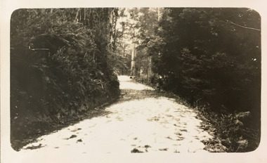 Kew Historical Society Inc
Photograph - Country road, c.1927
... Here the photographer takes a snapshot of a winding dirt track/road, thickly forested with native vegetation. The photograph is emblematic of the journey. ...Here the photographer takes a snapshot of a winding dirt track/road, thickly forested with native vegetation. The photograph is emblematic of the journey. ...Henry Beater Christian (1886-1962) , was a descendant of one of the earliest settler families in Kew. Employed at the Kew Asylum as a 'public servant', he was a skilled amateur photographer, photographing numerous scenes in Kew and on his travels around Victoria. The majority of his photographs date from 1916 to 1929. His finest photographs are housed in two photograph albums. Digital copy of a photograph from page 25 of the 47-page photograph album containing 261 gelatinous silver images, loaned by Diane Washfold with permission given to digitise and hold a copy in our collection. John Chapman has written in 'Bushwalking Clubs - A Brief History', about the establishment in Victoria of the first bushwalking club in 1888, and the popularisation of bushwalking during the interwar period. Henry Christian's 'walks' appear to have been undertaken solely or with a companion/s. Here the photographer takes a snapshot of a winding dirt track/road, thickly forested with native vegetation. The photograph is emblematic of the journey. Inscription on page illegiblehenry beater christian (1886-1962), landscape photography, christian-washfold collection, photograph albums, bushwalking -
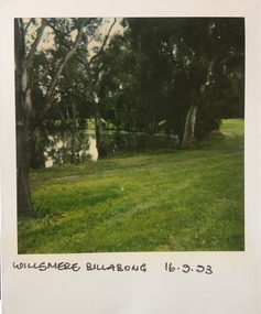 Kew Historical Society Inc
Photograph - Willsmere [Kew] Billabong, 1993
... It is only along the banks of the Yarra that there is any remnant native vegetation. Willsmere Park is of significance as an area of open land that remains from the flood plain that once dominated northern Kew. ...It is only along the banks of the Yarra that there is any remnant native vegetation. Willsmere Park is of significance as an area of open land that remains from the flood plain that once dominated northern Kew. ...Willsmere Park is bounded by the the Yarra River, Green Acres Golf Club, Willow Grove and the Eastern Freeway. The land on which the park is now situated was bought by Thomas Wills at the Crown Land Sales of 1846 (Section 56). From the 1840s to the 1940s it was intensively farmed. The park is dominated by very large playing fields, while planting to the southern boundary was undertaken when the Eastern Freeway was built. It is only along the banks of the Yarra that there is any remnant native vegetation. Willsmere Park is of significance as an area of open land that remains from the flood plain that once dominated northern Kew. (Source: Kew Conservation Study, 1988)Original colour small format polaroid photograph of the 'Kew Billabong' in the Willsmere Park, taken on 16 September 1993."Willsmere Billabong 16.9.93"kew billabong, willsmere park, yarra river -- billabongs -
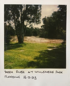 Kew Historical Society Inc
Photograph - Yarra River in flood at the Willsmere Park, 1993
... It is only along the banks of the Yarra that there is any remnant native vegetation. Willsmere Park is of significance as an area of open land that remains from the flood plain that once dominated northern Kew. ...It is only along the banks of the Yarra that there is any remnant native vegetation. Willsmere Park is of significance as an area of open land that remains from the flood plain that once dominated northern Kew. ...Willsmere Park is bounded by the the Yarra River, Green Acres Golf Club, Willow Grove and the Eastern Freeway. The land on which the park is now situated was bought by Thomas Wills at the Crown Land Sales of 1846 (Section 56). From the 1840s to the 1940s it was intensively farmed. The park is dominated by very large playing fields, while planting to the southern boundary was undertaken when the Eastern Freeway was built. It is only along the banks of the Yarra that there is any remnant native vegetation. Willsmere Park is of significance as an area of open land that remains from the flood plain that once dominated northern Kew. (Source: Kew Conservation Study, 1988)Original colour small format polaroid photograph of the Yarra River in flood at the Willsmere Park, taken on 16 September 1993."Yarra River at Willsmere Park Flooding 16.9.93"willsmere park, yarra river -- floods -- kew (vic.) -
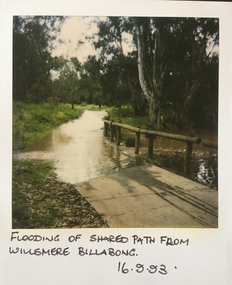 Kew Historical Society Inc
Photograph - Flooding in the Willsmere Park, 1993
... It is only along the banks of the Yarra that there is any remnant native vegetation. Willsmere Park is of significance as an area of open land that remains from the flood plain that once dominated northern Kew. ...It is only along the banks of the Yarra that there is any remnant native vegetation. Willsmere Park is of significance as an area of open land that remains from the flood plain that once dominated northern Kew. ...Willsmere Park is bounded by the the Yarra River, Green Acres Golf Club, Willow Grove and the Eastern Freeway. The land on which the park is now situated was bought by Thomas Wills at the Crown Land Sales of 1846 (Section 56). From the 1840s to the 1940s it was intensively farmed. The park is dominated by very large playing fields, while planting to the southern boundary was undertaken when the Eastern Freeway was built. It is only along the banks of the Yarra that there is any remnant native vegetation. Willsmere Park is of significance as an area of open land that remains from the flood plain that once dominated northern Kew. (Source: Kew Conservation Study, 1988)Original colour small format polaroid photograph of flooding in the Willsmere Park, taken on 16 September 1993."Flooding of shared path from Willsmere Billabong 16.9.93"willsmere park, yarra river -- floods -- kew (vic.), kew billabong