
Showing 43 items matching "nautical navigation"
-
 Flagstaff Hill Maritime Museum and Village
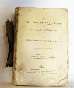
Book - Technical Reference, Henry Raper, Lieut. R.N, The Practice of Navigation and Nautical Astronomy, 1891
... The Practice of Navigation and Nautical Astronomy......nautical navigation...It includes topics on nautical navigation, astronomy, navigation charts, calculations and mathematical tables, time, tides, ships, longitude, and position at sea. ...Title: The Practice of Navigation and Nautical Astronomy Author: Henry Raper, Lieut, R.N., F.R.A.S., F.R.G.S. ...It includes topics on nautical navigation, astronomy, navigation charts, calculations and mathematical tables, time, tides, ships, longitude, and position at sea. ...This technical textbook is the nineteenth edition of the book by Henry Raper, Lieutenant in the Royal Navy with awards that include F.R.A.S. (Fellow of the Royal Astronomical Society) and F.R.G.S. (Friend of the Royal Geographical Society). The book is dedicated in honour of Rear-Admiral Sir Francis Beaufort K.C.B., Hydrographer to the Admiralty. He was awarded the title K.C.B. (King's Commander) as a Member of the Order of Bath, an order of British Chivalry, The book was first published in 1840 and soon became a resource for navigation students. It includes topics on nautical navigation, astronomy, navigation charts, calculations and mathematical tables, time, tides, ships, longitude, and position at sea. Thomas A. Hull, who revised and expanded this edition, was a Commander in the Royal Navy and had previously been Superintendent of Admiralty Charts used for navigation worldwide by seamen from many walks of life. The publisher, J D Potter of London, was at that time the sole agent for the Admiralty Charts produced by the Royal Navy. Printer Spottswoode and Co.,. was established by William Strachan in 1738. In 1819 his nephews A and R Spottswoode took over the business and bought premises in New-Street Square and Shoe Lane. In 1850 over 200 workers were employed by the firm. and five years later the business became Spottswoode & Co. Andrew Spottswoode invented the Spottswoode Press.This technical book was very popular as a textbook for students of maritime navigation, written and updated by members of the British Royal Navy and relied upon for accurate advice and information. The first edition was published in 1840, this edition was updated, expanded and published in 1891 when ports around the world were filling with travellers, merchants and business people. Title: The Practice of Navigation and Nautical Astronomy Author: Henry Raper, Lieut, R.N., F.R.A.S., F.R.G.S. Nineteenth Edition, revised and enlarged by Commander Thomas A. Hull, R.N., Late Superintendant of Admiralty Charts Dedication: To Rear-Admiral Sir Francis Beaufort K.C.B. Publisher: J D Potter, London, sole agent for the sale of Admiralty Charts Printer: Spottswoode and Co. New-Street Square, London Date: 1891 Small leather hardcover book with gold embossed text and lines on the spine. The Dedication in the book is as follows: - "To Rear-Admiral Sir Francis Beaufort K.C.B. Hydrographer to the Admiralty. Sir, The eminent station which you occupy in the naval scientific world renders it highly gratifying to me to dedicate the following Work to you as a testimony of my regard and esteem; while the general accordance of my views on the subject with those of your more experienced judgement, gives me the greater confidence in laying my labours before the Public. I have the honour to be, Sir, Your obedient servant, HENRY RAPER"flagstaff hill maritime museum, maritime museum, shipwreck coast, flagstaff hill, warrnambool, flagstaff hill maritime village, book, navigation, nautical astronomy, hydrography, nautical charts, nautical navigation, astronomical navigation, admiralty charts, henry raper, thomas a. hull, royal navy, j d potter, royal astronomical society, royal geographical society, calculations, mathematical tables, longitude, latitude, nautical time, location at sea, position at sea, maritime, practical navigation, spottswoode and co., sir francis beaufort, k.c.b., rear-admiral sir francis beaufort, hydrographer to the admiralty, scientific book, naval science -
 Phillip Island and District Historical Society Inc.
Book, JEANS, H.W, Navigation and nautical astronomy, the practical part, containing rules for finding the latitude and longitude, and the variation of the compass, with numerous examples, 1853
... Navigation and nautical astronomy, the practical part, containing rules for finding the latitude and longitude, and the variation of the compass, with numerous examples...Pencilled drawing inside back cover, 'hope' & 'anchor'. Navigation and nautical astronomy, the practical part, containing rules for finding the latitude and longitude, and the variation of the compass, with numerous examples Book JEANS, H.W. ...Inscribed 'Jno. Cleeland, Melbourne'. Labelled 'Phillip Island Historical Society, Cleeland Bequest'. Pencilled drawing inside back cover, 'hope' & 'anchor'. -
 Flagstaff Hill Maritime Museum and Village
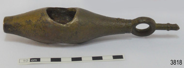
Instrument - Ship Log
... ...nautical navigation...TAFFRAIL LOGS A taffrail log is a nautical instrument used for measuring the speed of a vessel, providing vital navigational information to be calculated, such as location and direction. ...The Grange is an example of a mid-19th century vessel that carried a weapon of defence onboard. flagstaff hill warrnambool flagstaff hill maritime museum maritime museum shipwreck coast flagstaff hill maritime village great ocean road west coast trader apollo bay mid-19th century shipwreck the grange scottish barque little henty reef captain a alexander underwater explorers club of victoria vhr 5297 coastal trader wooden shipwreck john chance wooden ship taffrail log marine instrument marine technology navigation nautical instrument mechanical log nautical navigation navigation equipment scientific instrument ship log ship log register ship speed taff rail log patent log towed log taffrail log fish edward massey thomas walker Ship log fitting, called a fish; part of a brass navigational instrument, likely to be from a taffrail log. ...The ship's log part, called a fish, is likely to be from a mechanical taffrail log system. It was recovered from the wreck site of the barque, the 1840-1852 Grange. There are no marks on the fish to identify its maker or model. It is part of the John Chance Collection. This ‘fish’ is part of an early to mid-1800s ship's log. It would likely have been part of a taffrail log connected to a rotor (also called propeller, spinner) by a strong line, and the other end connected by a line to a dial mounted on the taffrail, or stern rail, at the stern of the vessel. As the propeller rotated through the water it would spin the log, which in turn would cause a number to register on the dial, showing the current speed in knots; one knot equals one nautical mile per hour. TAFFRAIL LOGS A taffrail log is a nautical instrument used for measuring the speed of a vessel, providing vital navigational information to be calculated, such as location and direction. A log has been used to measure the speed of a vessel since the 1500s. A simple piece of wood was tied to a long line and thrown into sea at the back of the vessel. The rope was knotted all along at equal distances apart. On a given signal the log line was pulled back into the vessels, the knots counted until the log came up, then the figures were calculated by a navigator In 1802 the first successful mechanical log available for general use was invented by Edward Massey. It had a rotor 'V' section connected to a recording mechanism. The water’s movement rotated the rotor, which intern sent the movement to the recorder. There are examples of this invention available to see in some of the maritime museums. Thomas Walker, nephew of Edward Massey, improved on Massey’s design, and Walker and his son took out a patent on the A1 Harpoon Log. In 1861. Both Massey and Walker continued to improve the designs of the taffrail log. New designs were still being introduced, even up to the 1950s. THE GRANGE, 1840-1858- The wooden barque ’Grange’ was a three-masted ship built in Scotland in 1840 for international and coastal trade. On March 22, 1858, the Grange set sail from Melbourne under Captain A. Alexander, carrying a cargo of ballast. The barque had left the Heads of Phillip Bay and was heading west along the Victorian coast towards Cape Otway. The ship struck Little Haley’s Reef at Apollo Bay due to a navigational error and was stuck on the rocks. The crew left the ship carrying whatever they could onto the beach. Eventually, the remains of the hull, sails and fittings were salvaged before the wreck of the Grange broke up about a month later. About 110 years later, in 1968, the wreck of the Grange was found by divers from the Underwater Explorers Club of Victoria. They were amazed to find a unique, six to nine pound carronade (type of small cannon) and a cannonball on the site. There have been no other similar carronades recorded. In that same year the anchor of the Grange was recovered by diver John Chance and Mal Brown. The ship’s log is significant historically as an example of hardware used when building wooden ships in the early to mid-19th century. The ship’s log is historically significant as an example of the work and trade of blacksmith. The ship’s log also has significant as it was recovered by John Chance, a diver from the wreck of the Grange in the 1968. Items that come from several wrecks along Victoria's coast have since been donated to the Flagstaff Hill Maritime Village’s museum collection by his family, illustrating this item’s level of historical value. The ship’s log is historically significant for its association with the 1840s wooden barque, the Grange. The Grange is an historical example of a Scottish built vessel used for international and coastal trader of both cargo and passengers in the mid-19th century. The Grange is an example of an early ship, designed with a wooden hull. It is significant as a ship still available to divers along the south coast of Victoria, for research and education purposes. The Grange is an example of a mid-19th century vessel that carried a weapon of defence onboard. Ship log fitting, called a fish; part of a brass navigational instrument, likely to be from a taffrail log. The metal is a tan colour and has rough surface with a sheen, and discolouration in places. Its basic shape is a hollow cylinder with ends tapering to a smaller size. In the centre there are opposing openings cut out, showing a rough texture inside. One end on the cylinder is closed with a ring and shank installed, fixed by an embedded screw through the end of the cylinder. There are no inscriptions.flagstaff hill, warrnambool, flagstaff hill maritime museum, maritime museum, shipwreck coast, flagstaff hill maritime village, great ocean road, west coast trader, apollo bay, mid-19th century shipwreck, the grange, scottish barque, little henty reef, captain a alexander, underwater explorers club of victoria, vhr 5297, coastal trader, wooden shipwreck, john chance, wooden ship, taffrail log, marine instrument, marine technology, navigation, nautical instrument, mechanical log, nautical navigation, navigation equipment, scientific instrument, ship log, ship log register, ship speed, taff rail log, patent log, towed log, taffrail log fish, edward massey, thomas walker -
 Flagstaff Hill Maritime Museum and Village
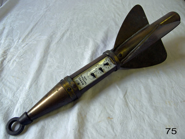
Instrument - Ship Log, 1880-1890
... ...nautical navigation...nautical instruments and compass adjusters. In fact, John Enos Hand, the company founder, is recognised as the first man in America to adjust a compass aboard an iron ship. The Hand Company built navigational...In 1997, California-based Sunset Cliffs Merchandising Corporation purchased the Hand Company and all its assets for $100,000. flagstaff hill warrnambool shipwrecked coast flagstaff hill maritime museum maritime museum shipwreck coast flagstaff hill maritime village great ocean road bartram hand john enos hand john f. hand and sons co john l hand john hand & sons instrument makers john hand & sons of philadelphia marine instrument marine service station mechanical ship log nautical instrument nautical navigation navigational equipment scientific instrument ship log ship log register ship’s speed sunset cliffs merchandising corporation speed log rocket log harpoon log taffrail log taff rail log Diagram of the 'Hand' trademark with a compass card in the middle, inscription reads "John F Hand and Sons Co" and "PHILA-BALTO" ( Abbreviation for: Philadelphia / Baltimore) "HAND" brand taffrail log by John F. ...The John E. Hand & Sons Company was founded in Philadelphia in 1873, quickly gaining a reputation as competent manufacturers of nautical instruments and compass adjusters. In fact, John Enos Hand, the company founder, is recognised as the first man in America to adjust a compass aboard an iron ship. The Hand Company built navigational equipment for all varieties of floating vessels, and operated a chain of retail outlets with “service stations” in numerous port cities, including Baltimore and New Orleans, until 1956. Service stations sold Hand instruments as well as other nautical paraphernalia and provided compass adjusting services. Additionally, John E Hand and his two sons, John L Hand and Bartram Hand, were inventors in their own right who patented design improvements for numerous instruments that were employed in the company’s work. Commercial and private contracts dominated the firm’s business until the late 1930s when the United States military began preparations for World War II. Although the Hand Company never completely abandoned its involvement with private industry, after World War II, military contracts monopolised their business. The Company obtained contracts with the Navy, Coast Guard and Marines to develop new instruments, and to build military-engineered nautical equipment. Of note are the wrist compass, developed for the Navy beginning in the 1950s, and the Mark VII Model 5 Navy Standard Binnacle. Although it moved numerous times, the Hand Company headquarters and factory remained in the Delaware Valley, occupying several buildings in Philadelphia and southern New Jersey. Maintaining its central office in Philadelphia well into the 1900s, the factory was moved to Atco, New Jersey around the turn of the twentieth century and subsequently to Haddon field, New Jersey. It moved one last time in the 1960s to Cherry Hill, New Jersey. In 1997, California-based Sunset Cliffs Merchandising Corporation purchased the Hand Company and all its assets for $100,000. "HAND" brand taffrail log by John F. Hand and Sons Co. Register is enclosed in log, has a glass front and 3 dials on an enameled surface, the first dial registers the miles up to 100, the second registers the units up to 10 mile, the third registers quarters of a mile. The item is rocket shaped with a three blade rotor and a rope ring attachment at one end; the rotor will spin when a rope is attached, allowing the apparatus dials to measure the ship's speed when it is dragged behind a ship. Diagram of the 'Hand' trademark with a compass card in the middle, inscription reads "John F Hand and Sons Co" and "PHILA-BALTO" ( Abbreviation for: Philadelphia / Baltimore) flagstaff hill, warrnambool, shipwrecked coast, flagstaff hill maritime museum, maritime museum, shipwreck coast, flagstaff hill maritime village, great ocean road, bartram hand, john enos hand, john f. hand and sons co, john l hand, john hand & sons instrument makers, john hand & sons of philadelphia, marine instrument, marine service station, mechanical ship log, nautical instrument, nautical navigation, navigational equipment, scientific instrument, ship log, ship log register, ship’s speed, sunset cliffs merchandising corporation, speed log, rocket log, harpoon log, taffrail log, taff rail log -
 Flagstaff Hill Maritime Museum and Village
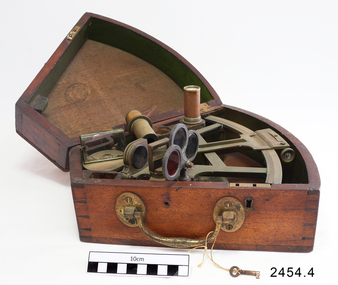
Octant, Mid to late 19th Century
... ...navigation...nautical...The invention of the octant was a significant step in providing accuracy of a sailors latitude position at sea and his vessels distance from land when taking sightings of land-based landmarks. instrument flagstaff hill warrnambool shipwrecked coast flagstaff hill maritime museum maritime museum shipwreck coast flagstaff hill maritime village great ocean road octant navigation nautical instrument navigation instrument john hadley sextant astronomical instrument Ink stamp inside lid of box "SHIPLOVERS SOCIETY OF VICTORIA. ...An octant is an astronomical instrument used in measuring the angles of heavenly bodies such as the sun, moon and stars at sea in relation to the horizon. This measurement could then be used to calculate the altitude of the body measured, and then the latitude at sea could also be calculated. The angle of the arms of an octant is 45 degrees, or 1/8 of a circle, which gives the instrument its name. Two men independently developed the octant around 1730: John Hadley (1682–1744), an English mathematician, and Thomas Godfrey (1704–1749), a glazier in Philadelphia. While both have a legitimate and equal claim to the invention, Hadley generally gets the greater share of the credit. This reflects the central role that London and the Royal Society played in the history of scientific instruments in the eighteenth and nineteenth century's. There were also two others who are attributed to having created octanes during this period, Caleb Smith, an English insurance broker with a strong interest in astronomy (in 1734), and Jean-Paul Fouchy, a mathematics professor and astronomer in France (in 1732) In 1767 the first edition of the Nautical Almanac tabulated lunar distances, enabling navigators to find the current time from the angle between the sun and the moon. This angle is sometimes larger than 90°, and thus not possible to measure with an octant. For that reason, Admiral John Campbell, who conducted shipboard experiments with the lunar distance method, suggested a larger instrument and the sextant was developed. From that time onward, the sextant was the instrument that experienced significant development and improvements and was the instrument of choice for naval navigators. The octant continued to be produced well into the 19th century, though it was generally a less accurate and less expensive instrument. The lower price of the octant, including versions without a telescope, made it a practical instrument for ships in the merchant and fishing fleets. One common practice among navigators up to the late nineteenth century was to use both a sextant and an octant. The sextant was used with great care and only for lunar sightings while the octant was used for routine meridional altitude measurements of the sun every day. This protected the very accurate and pricier sextant while using the more affordable octant for general use where it performs well. The invention of the octant was a significant step in providing accuracy of a sailors latitude position at sea and his vessels distance from land when taking sightings of land-based landmarks.Octant with metal handle, three different colored shades are attached, in wooden wedge-shaped box lined with green felt. Key is attached. Two telescope eyepieces are in box. Some parts are missing. Oval ink stamp inside lid of box, scale is graduated to 45 degrees. Ink stamp inside lid of box "SHIPLOVERS SOCIETY OF VICTORIA. LIBRARY"instrument, flagstaff hill, warrnambool, shipwrecked coast, flagstaff hill maritime museum, maritime museum, shipwreck coast, flagstaff hill maritime village, great ocean road, octant, navigation, nautical instrument, navigation instrument, john hadley, sextant, astronomical instrument -
 Flagstaff Hill Maritime Museum and Village
Ship Log, 1900-1920
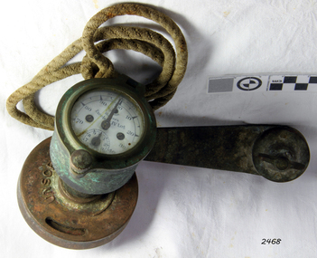
... navigation...a1 harpoon log...cherub’ log...walker’s excelsior mark iv log...ship’s log instrument...mechanical ship’s log...measure ship’s speed...nautical...It demonstrates the huge leap taken to improve navigational accuracy at sea with an instrument that was in use for decades. flagstaff hill warrnambool shipwrecked-coast flagstaff-hill flagstaff-hill-maritime-museum maritime-museum shipwreck-coast flagstaff-hill-maritime-village log register taff rail log taffrail log marine navigation a1 harpoon log cherub’ log walker’s excelsior mark iv log ship’s log instrument mechanical ship’s log measure ship’s speed nautical instrument navigation instrument massey & sons thomas walker blue brick walker thomas walker & son thomas ferdinand walker 48 hour work week "Walker's Excelsior IV Log", "Made in England by Thomas Walker, Birmingham" Ship's Taff Rail Log, rope attached. ...The Excelsior IV Log is a nautical instrument for measuring a vessel’s speed and distance travelled. When navigating a ship it is essential to be able to estimate the boat’s speed and distance travelled to determine its position at sea. In times past the only way to measure a ship’s speed was to throw a wood log into the water and observe how fast it moved away from the ship. In the 16th century, the log was fastened to a rope knotted at set intervals. The log was thrown over the stern (back) of the vessel and a crew member counted the number of knots that were paid out in a set time. From this, they could estimate the speed of the vessel through the water. This was known as streaming the log and is also the derivation of the knot as a measurement of nautical speed. The Walker’s Excelsior Mark IV instrument was designed for smaller vessels, such as yachts, launches and fishing vessels. Historical: Thomas Walker & Son was internationally renowned in the manufacturing of ships logs, founding father , Thomas Walker (1805–1871), an engineer in Birmingham, patented a mechanical log in 1878 which was a recording instrument that attached to a rail at the stern of a vessel connected by a long cord with a rotor which was towed behind the ship. The instrument dial recorded the distance travelled. Thomas Walker first went into business to manufacture stoves at 58 Oxford Street Birmingham. Walker’s self-feeding stove was widely lauded at the Paris Exhibition of 1855, winning a prize medal and kick starting the first of many notable innovations for the Walker family's manufacturing business. However, it wasn’t until working on an earlier ship’s log model invented by his Uncle that Thomas Walker became interested in the further development of this device, used to ascertain a ship’s speed. Walker continued to improve on the common log for the company of Massey & Sons and these improvements were deemed revolutionary. This log became a firm favourite of the West India Association (British-based organisation promoting ties and trade with the British Caribbean), being the most common log in use for two generations. It took until 1861 for Thomas Walker and his son, Thomas Ferdinand Walker (1831-1921) to patent the first Walker log of many. Together, with the introduction of the A1 Harpoon Log two years later, they established the Walker Log Business as a force to be reckoned with. By the time of his passing in 1871, Thomas Walker Snr had not only founded a family business with considerable staying power but also instilled a tradition of public service. Having sat as a representative on the Birmingham Town Council for 15 years and played an active role in public works, he was soon given the nickname of ‘Blue Brick Walker’. Much like his father, Thomas Ferdinand Walker changed the face of the maritime industry. His patent of 1897, the ‘Cherub’ log, was a notable departure from the past providing a far more accurate reading and replacing the majority of logs of the age. They were the first to produce an electric log and the Walker factory was one of the first to introduce the 48 hour work week for employees. The ship log was invented and made by a significant marine instrument maker and innovator of machinery. It demonstrates the huge leap taken to improve navigational accuracy at sea with an instrument that was in use for decades.Ship's Taff Rail Log, rope attached. Walker's Excelsior IV Log model. Nautical miles dials: units and 10's. "Walker's Excelsior IV Log", "Made in England by Thomas Walker, Birmingham"flagstaff hill, warrnambool, shipwrecked-coast, flagstaff-hill, flagstaff-hill-maritime-museum, maritime-museum, shipwreck-coast, flagstaff-hill-maritime-village, log register, taff rail log, taffrail log, marine navigation, a1 harpoon log, cherub’ log, walker’s excelsior mark iv log, ship’s log instrument, mechanical ship’s log, measure ship’s speed, nautical instrument, navigation instrument, massey & sons, thomas walker, blue brick walker, thomas walker & son, thomas ferdinand walker, 48 hour work week -
 Flagstaff Hill Maritime Museum and Village
Parallel Rule, Early 20th Century
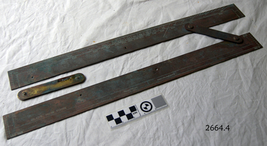
... ...nautical object...navigation...The item was made by a well known American maker of nautical instruments and is significant in regards to it's provenience and history of the maker and his family who over the years had been innovators and makers of various types of nautical instruments since 1795. flagstaff hill warrnambool shipwrecked-coast flagstaff-hill flagstaff-hill-maritime-museum maritime-museum shipwreck-coast flagstaff-hill-maritime-village parallel rule map reading nautical object navigation instrument Bliss of New York & Nautical instruments engraved on face of ruler, ruler divided into degrees for use on nautical maps Parallel map ruler. ...John Bliss (1795-1857) was born in Norwich Connecticut, trained as a silversmith and clockmaker in Vermont, and began in business as a jeweller in New York around 1830. In 1834, now trading as Bliss & Creighton, he made and marketed a range of nautical instruments. The business subsequently became John Bliss & Son in 1855 and John Bliss & Co. in 1857. It remained in business until 1957 when it was acquired by West Marine. The Bliss company used to make a range of instruments supplied to a variety of customers including the US Navy. An object made as an aid for marine navigation, to plot a course on a nautical map for a vessel to follow. The item was made by a well known American maker of nautical instruments and is significant in regards to it's provenience and history of the maker and his family who over the years had been innovators and makers of various types of nautical instruments since 1795. Parallel map ruler. Bliss of New York & Nautical instruments engraved on face of ruler, ruler divided into degrees for use on nautical mapsflagstaff hill, warrnambool, shipwrecked-coast, flagstaff-hill, flagstaff-hill-maritime-museum, maritime-museum, shipwreck-coast, flagstaff-hill-maritime-village, parallel rule, map reading, nautical object, navigation instrument -
 Mission to Seafarers Victoria
Book (Item) - Logbook, Captain George Garrett Kitching (1926 - 2005), Master's Log - Captain G.G. Kitching, 1956
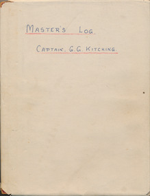
... ...nautical instrument...navigation...He served on these ships: SS Corinda SS Macumba SS Mildura SS Nellor SS Ormiston SS Reynella anne rennie collection wal harbord merchant navy seamen seafarers ww2 battle of the atlantic walter harbord hezzanith sextant nautical instrument navigation captain g.g. kitching m.v. trienza m.v. triaster m.v. triellis bpc ship log radiogram phosphate nauru Red leather covered in cream paper notebook recording the log of the ships MV Trienza, Triaster, Triellis handwrittem by the Captain G.G. ...The British Phosphate Commissioners (BPC) was a board of Australian, British, and New Zealand representatives who managed extraction of phosphate from Christmas Island, Nauru, and Banaba (Ocean Island) from 1920 until 1981. Walter Harbord (Wal or Wally) (b.1923 in Brisbane-d.), master mariner in the Merchant Navy on British Phosphate Commission ships.Walter was interviewed by the Australian at War Film Archive in 2003. He served on these ships: SS Corinda SS Macumba SS Mildura SS Nellor SS Ormiston SS Reynellaanne rennie collection, wal harbord, merchant navy, seamen, seafarers, ww2, battle of the atlantic, walter harbord, hezzanith, sextant, nautical instrument, navigation, captain g.g. kitching, m.v. trienza, m.v. triaster, m.v. triellis, bpc, ship log, radiogram, phosphate, nauru -
 Mission to Seafarers Victoria
Flag - House flag, BPC, 1945
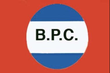
... ...nautical instrument...navigation...He served on these ships: SS Corinda SS Macumba SS Mildura SS Nellor SS Ormiston SS Reynella anne rennie collection wal harbord merchant navy seamen seafarers ww2 battle of the atlantic walter harbord hezzanith sextant nautical instrument navigation captain g.g. kitching m.v. trienza m.v. triaster bpc BPC Flag House flag ...The British Phosphate Commissioners (BPC) was a board of Australian, British, and New Zealand representatives who managed extraction of phosphate from Christmas Island, Nauru, and Banaba (Ocean Island) from 1920 until 1981. Walter Harbord (Wal or Wally) (b.1923 in Brisbane-d.), master mariner in the Merchant Navy on British Phosphate Commission ships.Walter was interviewed by the Australian at War Film Archive in 2003. He served on these ships: SS Corinda SS Macumba SS Mildura SS Nellor SS Ormiston SS Reynellaanne rennie collection, wal harbord, merchant navy, seamen, seafarers, ww2, battle of the atlantic, walter harbord, hezzanith, sextant, nautical instrument, navigation, captain g.g. kitching, m.v. trienza, m.v. triaster, bpc -
 Mission to Seafarers Victoria
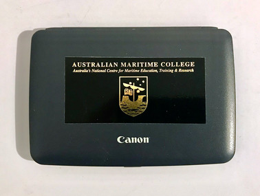
Instrument - Calculator with manual, Canon, ZX 2200, 1990-2000
... nautical instrument...navigation...nautical instrument navigation instrument brian mcmahon ship master Small black platic calculator Canon ZX 2200 with sticker from The Australian Maritime College with manual. ...Small black platic calculator Canon ZX 2200 with sticker from The Australian Maritime College with manual.nautical instrument, navigation instrument, brian mcmahon, ship master -
 Mission to Seafarers Victoria
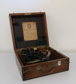
Instrument - Sextant in box, Heath & Co, 1945
... ...nautical instrument...navigation...He served on these ships: SS Corinda SS Macumba SS Mildura SS Nellor SS Ormiston SS Reynella anne rennie collection wal harbord merchant navy seamen seafarers ww2 battle of the atlantic walter harbord hezzanith sextant nautical instrument navigation Sextant in wooden box Instrument Sextant in box Heath & Co ...Sextant belonging to Walter Harbord (Wal or Wally) (b.1923 in Brisbane-d.), master mariner in the Merchant Navy on British Phosphate Commission ships.Walter was interviewed by the Australian at War Film Archive in 2003. He served on these ships: SS Corinda SS Macumba SS Mildura SS Nellor SS Ormiston SS ReynellaSextant in wooden boxanne rennie collection, wal harbord, merchant navy, seamen, seafarers, ww2, battle of the atlantic, walter harbord, hezzanith, sextant, nautical instrument, navigation -
 Mission to Seafarers Victoria
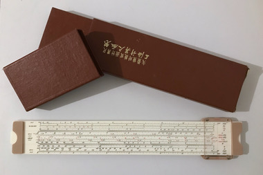
Instrument - Slide Rule in box, Shanghai Slide Rule Factory, 1978
... ...nautical instrument...navigation...He served on these ships: SS Corinda SS Macumba SS Mildura SS Nellor SS Ormiston SS Reynella anne rennie collection wal harbord merchant navy seamen seafarers ww2 battle of the atlantic walter harbord nautical instrument navigation slide rule flying fish 1017 Inscription in Chinese on the box Sextant in wooden box Instrument Slide Rule in box Shanghai Slide Rule Factory ...Sextant belonging to Walter Harbord (Wal or Wally) (b.1923 in Brisbane-d.), master mariner in the Merchant Navy on British Phosphate Commission ships. According to the website SLide Rule Museum this is the Flying Fish 1017 Chemical V2 Walter was interviewed by the Australian at War Film Archive in 2003. He served on these ships: SS Corinda SS Macumba SS Mildura SS Nellor SS Ormiston SS ReynellaSextant in wooden boxInscription in Chinese on the boxanne rennie collection, wal harbord, merchant navy, seamen, seafarers, ww2, battle of the atlantic, walter harbord, nautical instrument, navigation, slide rule, flying fish 1017 -
 Flagstaff Hill Maritime Museum and Village
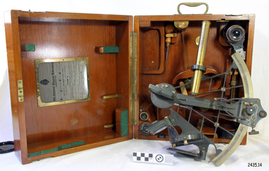
Instrument - Navigational Sextant, 1882-1890
... Earlier links can be found to Bartholomew Gosnold (1571–1607) indicating that the use of a sextant for nautical navigation predates Hadley's implementation. ...Earlier links can be found to Bartholomew Gosnold (1571–1607) indicating that the use of a sextant for nautical navigation predates Hadley's implementation. ...A sextant is an astronomical instrument used to determine latitude and longitude at sea by measuring angular distances, especially the altitudes of the sun, moon, and stars. It is a doubly reflecting navigation instrument and used mainly by sailors to measure the angular distance between two visible objects. The name comes from the Latin sextans, or “sixth part of a unit,” because the sextant’s arc can be 60° or 120° of a circle depending on the model used. The primary use was to measure the angle between an astronomical object and the horizon for the purposes of celestial navigation. The estimation of this angle is known as sighting or shooting the object, or taking a sight. This angle and the time when it was measured is used in order to determine Greenwich Mean Time and hence longitude. Sighting the height of a landmark on land can also give a measure of distance from that object. History: The development of the sextant was as an improvement over the octant, an instrument designed to measure one's latitude. The octant was first implemented around 1731-present but can only measure angles up to 45°. As larger angles were needed to allow the measurement of lunar objects - moon, stars and the sun - at higher angles, the octant was superseded by the sextant. The sextant is a similar instrument but better made and allows larger angles from 60° to 120°. This improvement allows distances to be accurately calculated thereby giving longitude when used with a chronometer. The sextant was derived from the octant in 1757, eventually making all previous instruments used for navigational positioning obsolete. The sextant had been attributed to by John Hadley (1682–1744) and Thomas Godfrey (1704–1749), but reference to the sextant was also found later in the unpublished writings of Isaac Newton (1643–1727). Earlier links can be found to Bartholomew Gosnold (1571–1607) indicating that the use of a sextant for nautical navigation predates Hadley's implementation. In 1922, the sextant was modified for aeronautical navigation by Portuguese navigator and naval officer Gago Coutinho. It should be noted that the octant and quadrant are in the same family as they were, and all are, regarded as sextants. The sextant is representative of it's type and although not fully complete it demonstrates how 18th,19th and 20th century mariners determined their latitude and longitudinal to determine their position on a chart, allowing them to navigate there way across the world's oceans. It also demonstrates the skill and workmanship of the early instrument makers that operated scientific instrument businesses from London and other areas of England to provide most of the navigational instrumentation used by commercial and military navies of the time.Sextant with square, fitted box of polished wood, "Hezzanith" brand. Box contains many parts for the sextants use. On certificate "Heath & Co, London. Sextant Number Y 822". Catch on lid "DEFIANT LEVER" and "PATENT NUMBER 187.10". Maker's certificate is attached to the inside of the box.flagstaff hill, warrnambool, shipwrecked-coast, flagstaff-hill, flagstaff-hill-maritime-museum, maritime-museum, shipwreck-coast, flagstaff-hill-maritime-village, sextant box, sextant, hezzanith, heath & co, navigational instrument, george wilson heath, astronomical instrument, instrument manufacturers, scientific instrument, navigation, celestial navigation, octant, quadrant, lunar navigation -
 Flagstaff Hill Maritime Museum and Village
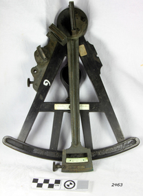
Octant, Late 18th to mid-19th century
... Earlier links can be found to Bartholomew Gosnold (1571–1607) indicating that the use of a Sextant for nautical navigation predates Hadley's implementation. ...Earlier links can be found to Bartholomew Gosnold (1571–1607) indicating that the use of a Sextant for nautical navigation predates Hadley's implementation. ...An Octant is a doubly reflecting navigation instrument used primarily by sailors to measure the angular distance between two visible objects and was a forerunner of the sextant. The name comes from the Latin octo, or “one-eighth of a circle,” for the Octant’s arc which spans 45°, or one-eighth of a circle. The primary use of an Octant is to measure the angle between an astronomical object and the horizon for the purposes of celestial navigation. The estimation of this angle is known as sighting or shooting the object, or taking a sight. The angle, and the time when it was measured, can be used to calculate a position line on a nautical chart (latitude), for example, sighting the Sun at noon or Polaris at night (in the Northern Hemisphere) gives an angle by which the latitude can then be estimated. Sighting the height of a landmark on land can also give a measure of distance. History: The principle of the Octant as an instrument to measure ones latitude was first implemented around 1742-present but was superseded by the improvement of the octant to a sextant, a very similar instrument, better made and able to measure bigger angles 120°, allowing the measurement of Luna distances to give longitude when used with an accurate chronometer. The sextant started to appear around 1730 and had been attributed to by John Hadley (1682–1744) and Thomas Godfrey (1704–1749), but reference to the sextant was also found later in the unpublished writings of Isaac Newton (1643–1727). Earlier links can be found to Bartholomew Gosnold (1571–1607) indicating that the use of a Sextant for nautical navigation predates Hadley's implementation. In 1922, the sextant was modified for aeronautical navigation by Portuguese navigator and naval officer Gago Coutinho. Henry Hemsley was a lesser-known instrument maker and optician working in London in the late 17th and early 18th century. However, it should be noted that there were two Henry Hemsley opticians and instrument makers around this period. (Henry Hemsley 1, 1786-89, who had premises at 85 Fleet St London and Henry Hemsley 2, 1828-56), whose workshop was at 135-138 Radcliff Highway London. Therefore, based on the inscribed workshop address Henry Hemsley 2 is responsible for making this example.The octant is representative of its type and although not fully complete it demonstrates how 18th and 19th-century mariners determined their latitude on a chart to navigate their way across the world's oceans in the 18th and 19th century. It also demonstrates the skill and workmanship of the early instrument makers that operated from London at this time and provided most of the navigational instrumentation use by commercial and military navies of the time.Octant, ebony wooden frame and handle. Scale is missing from recess in frame. "H. Hemsley 135-138 Ratliff Highway, London", no box"H. Hemsley 135-138 Ratcliff Highway, London"flagstaff hill, warrnambool, shipwrecked-coast, flagstaff-hill, flagstaff-hill-maritime-museum, maritime-museum, shipwreck-coast, flagstaff-hill-maritime-village, navigation, navigational instrument, instrument used for navigation, sextant, henry hemsley, instrument maker, london, octant -
 Flagstaff Hill Maritime Museum and Village
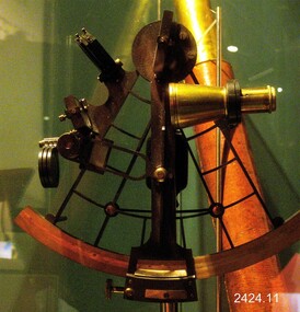
Instrument - Sextant, Late 20th Century
... Purchased as an exhibition of marine navigational instruments for the Flagstaff Hill museum. flagstaff hill warrnambool shipwrecked-coast flagstaff-hill flagstaff-hill-maritime-museum maritime-museum shipwreck-coast flagstaff-hill-maritime-village sextant kelvin & hughes ltd hong kong navigational instrument g falconer mariner's quadrants G Falconer and Co. Hong Kong (retailers of nautical equipment The Sextant is a brass apparatus with filters and telescope lens, and comes with a wooden felt lined storage box. ...In 1941, the scientific instrument manufacturing firms of Henry Hughes & Son Ltd, London, England, and Kelvin Bottomley & Baird Ltd, Glasgow, Scotland, came together to form Kelvin & Hughes Ltd. Kelvin Company History: The origins of the company lie in the highly successful and strictly informal relationship between William Thomson (1824-1907), Professor of Natural Philosophy at Glasgow University from 1846-1899 and James White, a Glasgow optical maker. James White (1824-1884) founded the firm of James White, an optical instrument maker in Glasgow in 1850 and was involved in supplying and mending apparatus for Thomson university laboratory and working with him on experimental constructions. White was declared bankrupt in August 1861 and released several months later. In 1870, White was largely responsible for equipping William Thomson laboratory in the new University premises at Gilmore hill. From 1876, he was producing accurate compasses for metal ships to Thomson design during this period and this became an important part of his business in the last years of his life. He was also involved in the production of sophisticated-sounding machinery that Thomson had designed to address problems encountered laying cables at sea, helping to make possible the first transatlantic cable connection. At the same time, he continued to make a whole range of more conventional instruments such as telescopes, microscopes and surveying equipment. White's association with Thomson continued until he died. After his death, his business continued under the same name, being administered by Matthew Edwards (until 1891 when he left to set up his own company. Thomson who became Sir William Thomson and then Baron Kelvin of Largs in 1892, continued to maintain his interest in the business after James White's death. In 1884 raising most of the capital needed to construct and equip new workshops in Cambridge Street, Glasgow. At these premises, the company continued to make the compass Thomson had designed during the 1870s and to supply it in some quantity, especially to the Admiralty. At the same time, the firm became increasingly involved in the design, production and sale of electrical apparatus. In 1899, Lord Kelvin resigned from his University chair and became, in 1900, a director in the newly formed limited liability company Kelvin & James White Ltd which had acquired the business of James White. At the same time Kelvin's nephew, James Thomson Bottomley (1845-1926), joined the firm. In 1904, a London branch office was opened which by 1915 had become known as Kelvin, White & Hutton Ltd. Kelvin & James White Ltd underwent a further change of name in 1913, becoming Kelvin Bottomley & Baird Ltd. Hughes Company History: Henry Hughes & Sons were founded in 1838 in London as a maker of chronographic and scientific instruments. The firm was incorporated as “Henry Hughes & Sons Ltd” in 1903. In 1923, the company produced its first recording echo sounder and in 1935 a controlling interest in the company was acquired by S Smith & Son Ltd resulting in the development and production of marine and aircraft instruments. Following the London office's destruction in the Blitz of 1941, a collaboration was entered into with Kelvin, Bottomley & Baird Ltd resulting in the establishing “Marine Instruments Ltd”. Following the formal amalgamation of Kelvin, Bottomley & Baird Ltd and Henry Hughes & Sons Ltd in 1947 to form Kelvin & Hughes Ltd. Marine Instruments Ltd then acted as regional agents in the UK for Kelvin & Hughes Ltd who were essentially now a part of Smith's Industries Ltd founded in 1944 and the successors of S. Smith & Son Ltd. Kelvin & Hughes Ltd went on to develop various marine radar and echo sounders supplying the Ministry of Transport, and later the Ministry of Defence. The firm was liquidated in 1966 but the name was continued as Kelvin Hughes, a division of the Smiths Group. In 2002, Kelvin Hughes continues to produce and develop marine instruments for commercial and military. G. Falconer Company History: G Falconer (Hong Kong Ltd) appear to have had a retail presence in Hong Kong since 1885, according to the company website, and currently have a shop in the Peninsula Hotel. G Falconer was the Hong Kong selling agent for several British companies. Ross Ltd of 111 New Bond St London was one and the other was Kelvins Nautical Instruments. Falconers were primarily watchmakers, jewellers and diamond merchants.They were also agents for Admiralty Charts, Ross binoculars and telescopes, and sold English Silverware and High Class English Jewellery. In 1928 the company was operating from the Union Building opposite the Hong Kong general post office. It is unclear if the item is an original Sextant made by Kelvin prior to his amalgamation with Henry Hughes & Sons in 1941 as Kelvin appears to have only made compasses up to this date. If the Sextant can be established that it was made by Kelvin then it is very significant and a rare item made for and distributed through their Hong Kong selling agents G Falconer Ltd. There are many Sextants advertised for sale stating "Kelvin & Hughes 1917 model sextant". These can be regarded as replicas as the company was not formed until 1941 and production of marine instruments was not fully under way until after the war in 1947. Further investigation needs to be undertaken to accurately determine the provenance of this item. As the writer currently has the impression that the subject object was possibly made by Kelvin and Hughes in the mid to late 20th century or is a replica made by an unknown maker in the late 1970s. Purchased as an exhibition of marine navigational instruments for the Flagstaff Hill museum. The Sextant is a brass apparatus with filters and telescope lens, and comes with a wooden felt lined storage box. It is a doubly reflecting navigation instrument that measures the angular distance between two visible objects. The primary use of a sextant is to measure the angle between an astronomical object and the horizon for the purposes of celestial navigation.G Falconer and Co. Hong Kong (retailers of nautical equipmentflagstaff hill, warrnambool, shipwrecked-coast, flagstaff-hill, flagstaff-hill-maritime-museum, maritime-museum, shipwreck-coast, flagstaff-hill-maritime-village, sextant, kelvin & hughes ltd, hong kong, navigational instrument, g falconer, mariner's quadrants -
 Flagstaff Hill Maritime Museum and Village
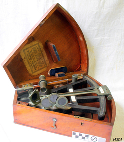
Instrument - Octant, mid 1800's
... navigation. The estimation of this angle, is known as sighting or shooting the object, or taking a sight. The angle, and the time when it was measured, can be used to calculate a position line on a nautical chart (latitude), for example, sighting the Sun at noon or Polaris at night (in the Northern Hemisphere) gives an angle by which the latitude can then be estimated. ...navigation. The estimation of this angle, is known as sighting or shooting the object, or taking a sight. The angle, and the time when it was measured, can be used to calculate a position line on a nautical chart (latitude), for example, sighting the Sun at noon or Polaris at night (in the Northern Hemisphere) gives an angle by which the latitude can then be estimated. ...An Octant is a doubly reflecting navigation instrument used primarily by sailors to measure the angular distance between two visible objects and was a forerunner of the sextant. The name comes from the Latin octo, or "one-eighth of a circle," for the Octan'ts arc which spans 45°, or one-eighth of a circle. The primary use of an Octant is to measure the angle between an astronomical object and the horizon for celestial navigation. The estimation of this angle, is known as sighting or shooting the object, or taking a sight. The angle, and the time when it was measured, can be used to calculate a position line on a nautical chart (latitude), for example, sighting the Sun at noon or Polaris at night (in the Northern Hemisphere) gives an angle by which the latitude can then be estimated. Sighting the height of a landmark on land can also give a measure of distance. This fine octant once belonged to Captain Farquhar Chisholm and was donated by his granddaughter, Margaret Ruth Greer (nee Chisholm, born 1914). The label inside the Octant's box reads “Thomas L. Ainsley, Instrument Maker … etc”. Farquhar Chisholm was born in 1832 in Inverness, Scotland. He regularly sailed on perilous voyages between Quebec, Canada and the Baltic ports of Europe. In 1854 he migrated to Australia during the Gold Rush, to a place called Fiery Creek (near Beaufort Victoria) where he was fairly successful in his quest for gold. In the years of the Great Gold Rush, it was said that there were over 40,000 diggers in the goldfields of the Beaufort area! In 1857 having made sufficient money, he hired another crew and returned to Clachnacuddin, Inverness shire, Scotland and in that same year, he studied and obtained his Master Mariner Certificate (which would have included the use of an octant for navigation). He was appointed to Mr George (or James) Walker, as commander of his sailing ship, the 3-masted ELIZABETH, built 1859 and known as “The Walker barque”. In 1870 he married, then in 1887 returned to Australia with his wife and children (Kenneth Chisholm (1871), Mary Bremner Chisholm (1873), Margaret Hood Chisholm (1874), Farquhar Chisholm (1878)). They arrived in Port Melbourne, Victoria and sadly, only six weeks after landing, his wife Caroline passed away (in Geelong,1888). In 1900 Capt. Chisholm lived in Camperdown (Victoria) and not long after this his daughter Margaret died of consumption. In his later years, he went to live in the manse of St. Paul’s Presbyterian Church, Wangaratta, with his son, Rev. Farquhar Chisholm. He died there on Sat, 23rd March 1912, 80 years old. He was known as “… quiet, unobtrusive and competent, respected by all with whom he came in contact”. Some other members of Captain Chisholm’s family are; his older son Kenneth Chisholm, who was a contractor in Camperdown; a nephew Donald Macintosh (of 23 Douglas Row, Inverness); a grandson Brian Jones (son of Caroline Belle-Jones nee Chisholm, who lived in Camperdown in the earlier part of her life).The octant, the forerunner of the sextant, was a significant step in providing accuracy of a sailors latitude position at sea & his vessels distance from land when taking sightings of land-based landmarks.Octant, once belonging to Captain Farquhar Chisholm. Wedge shape (the size of an eighth of a circle), made of wood, glass and metal. Used in the 1880s. Maker’s name across centre “L. SIMON - - - SHIELDS”. Three (3) light filtering, coloured glass shades. Two (2) eyepieces. Scale attached for measuring angles. Label inside the fitted, wedge-shaped case "Thomas L. Ainsley, Optician"Label inside case "Thomas L. Ainsley, Optician" Maker’s name across centre “L. SIMON - - - SHIELDS”.flagstaff hill, warrnambool, shipwrecked-coast, flagstaff-hill, flagstaff-hill-maritime-museum, maritime-museum, shipwreck-coast, flagstaff-hill-maritime-village, maritime navigation, navigation instrument, migration, captain chisholm, farquhar chisholm, sailing ship, the elizabeths, thomas l. ainsley, l. simons, shields england, octant, john hadley, chisholm -
 Flagstaff Hill Maritime Museum and Village
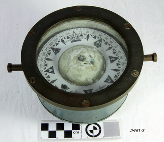
Compass, c. 1930s
... nautical compass...marine compass...maritime compass...technical instrument...navigation...Examples of the same compass that have been salvaged can be purchased today mounted either in a wooden box or a brass pedestal. flagstaff hill warrnambool shipwrecked coast flagstaff hill maritime museum maritime museum shipwreck coast flagstaff hill maritime village great ocean road compass nautical compass marine compass maritime compass technical instrument navigation instrument bergen nautik 20th-century marine compass gimbal compass ship's compass bergan nautik norway 1930s marine compass "BERGEN . ...The nautical compass is used for determining directions, using a free moving magnetised needle, indicating north and south. This is a medium sized compass and was suitable for mounting in a fixed brass binnacle or a portable wooden box. The compass fluid was typically lamp oil, or a mixture of alcohol and water. This compass, based on its pattern, was probably manufactured around the 1930s. The compass’s maker, Bergen Nautik, was a 20th Century compass manufacturer, making compasses from the 1900s but no longer in business.The factory was located in Hordaland County, Bergen, on the west coast of Norway. This compass is not a very significant marine item as it was made in the 20th century. Examples of the same compass that have been salvaged can be purchased today mounted either in a wooden box or a brass pedestal.Compass; marine or ship's compass, brass, gimbal mounting, in blue metal casing. Manufacturer’s inscription is on the face. Made by Bergen Nautik of Bergen in Norway. Circa 1930s."BERGEN . NAUTIK", "BERGEN", "NORWAY" flagstaff hill, warrnambool, shipwrecked coast, flagstaff hill maritime museum, maritime museum, shipwreck coast, flagstaff hill maritime village, great ocean road, compass, nautical compass, marine compass, maritime compass, technical instrument, navigation instrument, bergen nautik, 20th-century marine compass, gimbal compass, ship's compass, bergan nautik, norway, 1930s marine compass -
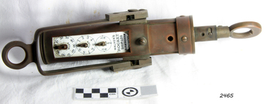 Flagstaff Hill Maritime Museum and Village
Ship Log, 1900-1920
... It demonstrates the huge leap taken to improve navigational accuracy at sea with an instrument that was in use for decades. flagstaff hill warrnambool shipwrecked-coast flagstaff-hill flagstaff-hill-maritime-museum maritime-museum shipwreck-coast flagstaff-hill-maritime-village ship log rocket log mechanical ship log measuring instrument marine instrument nautical instrument speed recording instrument ship log register walker ship log walkers rocket ship-log thomas walker thomas walker & son thomas ferdinand walker walker log business reynolds ship log rotor taffrail log taff rail log west india association "Walkers Rocket Ship-Log Birmingham (Patented)" printed on face-plate. ...Thomas Walker & Son was internationally renowned in the manufacturing of ships logs. Founding father Thomas Walker (1805–1871), an engineer in Birmingham, patented a mechanical log in 1878 which was a recording instrument that attached to a rail at the stern of a vessel connected by a long cord with a rotor which was towed behind the ship. The instrument dial recorded the distance travelled. Thomas Walker first went into business to manufacture stoves at 58 Oxford Street Birmingham. Walker’s self-feeding stove was widely lauded at the Paris Exhibition of 1855, winning a prize medal and kick starting the first of many notable innovations for the Walker family's manufacturing business. However, it wasn’t until working on an earlier ships log model invented by his Uncle that Thomas Walker became interested in the further development of this device, used to ascertain a ship’s speed. Walker continued to improve on the common log for the company of Massey & Sons and these improvements were deemed revolutionary. This log became a firm favourite of the West India Association (British-based organisation promoting ties and trade with the British Caribbean) and the most common log in use for two generations. It took till 1861 for Thomas Walker and his son, Thomas Ferdinand Walker (1831-1921) to patent the first Walker log of many. Together, with the introduction of the A1 Harpoon Log two years later, they established the Walker Log Business as a force to be reckoned with. By the time of his passing in 1871, Thomas Walker Snr had not only founded a family business with considerable staying power but also instilled a tradition of public service. Having sat as a representative on the Birmingham Town Council for 15 years and played an active role in public works, he was soon given the nickname of ‘Blue Brick Walker’. Much like his father, Thomas Ferdinand Walker changed the face of the maritime industry. His patent of 1897, the ‘Cherub’ log, was a notable departure from the past providing a far more accurate reading and replacing the majority of logs of the age. They were the first to produce an electric log and the Walker factory was one of the first to introduce the 48 hour work week for employees. This ship log was invented and made by a significant marine instrument maker and innovator of machinery. It demonstrates the huge leap taken to improve navigational accuracy at sea with an instrument that was in use for decades. Ship Log, three analogue dials calibrated in increments of Miles, the Rocket Log is a nautical instrument for measuring a vessel’s speed and distance traveled. The floating log was drawn behind the ship over a fixed time period in order to measure the distance traveled. The counter could measure enough miles to cover the maximum distance traveled by a ship in one day. The log has two distinct parts; a brass register, made by Walker, showing the distance recorded and the rotator made by Reynolds, that spins in the water driving the counter. both parts are connected by a linked chain. The register has a cylindrical brass body approx 4.5 cm diameter containing registering mechanism with hardened steel bearings. Distance is indicated by the three pointers on enamel plate as follows: graduated every 10 miles from 0-100; every mile from 1-10; every 1/4 mile from 1/4 -1. A brass sling and eye secured to the body enables it to be attached to the taffrail. The original rotator would have had a cylindrical tapered wooden body, approx 4.5 cm in diameter with three metal alloy fins or could be all made from brass. A towing eye is fitted to the tapered end. The two pieces of apparatus are connected by a length of linked chain, length 22.9 cm."Walkers Rocket Ship-Log Birmingham (Patented)" printed on face-plate. "Made by Thomas Walker".flagstaff hill, warrnambool, shipwrecked-coast, flagstaff-hill, flagstaff-hill-maritime-museum, maritime-museum, shipwreck-coast, flagstaff-hill-maritime-village, ship log, rocket log, mechanical ship log, measuring instrument, marine instrument, nautical instrument, speed recording instrument, ship log register, walker ship log, walkers rocket ship-log, thomas walker, thomas walker & son, thomas ferdinand walker, walker log business, reynolds ship log rotor, taffrail log, taff rail log, west india association -
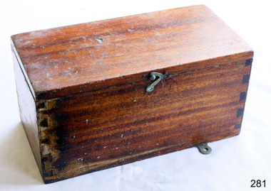 Flagstaff Hill Maritime Museum and Village
Container - Box
... navigation. The rudder indicator transmitter once contained in this box was battery operated, according to the label inside this box. flagstaff hill warrnambool shipwrecked-coast flagstaff-hill flagstaff-hill-maritime-museum maritime-museum shipwreck-coast flagstaff-hill-maritime-village siemen's brothers london siemen's rudder indicator box nautical instrument for measuring pitch or slope scientific instrument box navigational instrument box Box, wooden, used to store a battery operated Siemen's ship's rudder indicator. ...A ship's rudder indicator is used for measuring the angle of slope or pitch of the vessel. The information can be used to adjust the steering of the ship to give safe navigation. The rudder indicator transmitter once contained in this box was battery operated, according to the label inside this box. Box, wooden, used to store a battery operated Siemen's ship's rudder indicator. Made in the United Kingdom. Descriptive leaflet glued inside hinged lid. Lid secured by hooked catch. Brass latch. Metal mounting plate. Hole drilled in back. Dovetail joints. flagstaff hill, warrnambool, shipwrecked-coast, flagstaff-hill, flagstaff-hill-maritime-museum, maritime-museum, shipwreck-coast, flagstaff-hill-maritime-village, siemen's brothers london, siemen's rudder indicator box, nautical instrument for measuring pitch or slope, scientific instrument box, navigational instrument box -
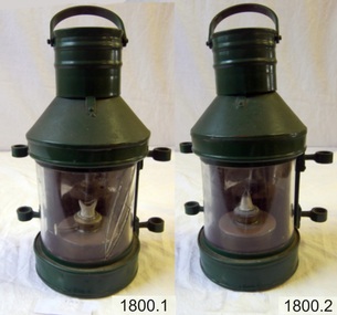 Flagstaff Hill Maritime Museum and Village
Functional object - Anchor Lamp, Bef. 09-02-1984
... navigation...light...ship light...ship lamp...lantern...maritime...nautical...The lamp is made to the design of a 19th and early 20th-century kerosene anchor lamp carried as essential marine equipment and used as a signal lamp on sailing ships. brass lamp lamp Anchor Kerosene Lamp kerosene lamp marine equipment marine lamp navigation light ship light ship lamp lantern maritime nautical safety lamp Lamps; a pair of cylindrical kerosene anchor lamps. ...The kerosene lamp was one of the most common oil lamps used and was manufactured until the 1980s. An anchor lamp like the lamps in this pair would be raised on the highest ship mast at night to signal other seafarers that the ship was at anchor or sailing at night. The metal loops on opposing sides of the lamp could hold a pair of rods or ropes. and be used to raise the lamp.The lamp is made to the design of a 19th and early 20th-century kerosene anchor lamp carried as essential marine equipment and used as a signal lamp on sailing ships. Lamps; a pair of cylindrical kerosene anchor lamps. Each has a flat back, a hinged door, a metal handle and two metal loops or guides fixed on each side. The glass window is convex and inside the lamp is a wick in an enamel wick holder.brass lamp, lamp, anchor kerosene lamp, kerosene lamp, marine equipment, marine lamp, navigation, light, ship light, ship lamp, lantern, maritime, nautical, safety lamp -
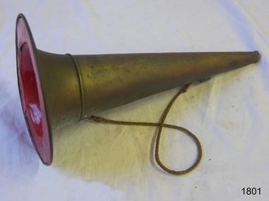 Flagstaff Hill Maritime Museum and Village
Functional object - Megaphone
... navigation...warning signal...maritime...nautical...It represents a similar instrument made in the 19th century and used as a signal or to give instructions, such as on a vessel at sea, to a lifesaving team, or in a marching band. warrnambool Flagstaff Hill Maritime Museum and Village fog horn marine equipment navigation warning signal maritime nautical fireman captain shoulder rope signal safety equipment Megaphone; brass conical shape with an opening at both ends and a join near the wide end. ...This megaphone's conical shape amplifies the sound from the narrow end and would have been used to signal a warning or give instructions. Its design is similar to an earlier brass fog horn used on a marine vessel, as it has a wide brim that allows it to be free-standing, and a shoulder rope makes it portable and frees up the user's hands. The narrow end is shaped into a mouthpiece. The megaphone may have been used at sea foghorn on a vessel, although it has no reeds for the sound, or used by a leader of a band or a fireman or other similar uses. This megaphone's conical shape is based on the centuries-old ram's horn or horn from other animals, used to amplify sound to make it travel a long distance or be heard above other sounds. It represents a similar instrument made in the 19th century and used as a signal or to give instructions, such as on a vessel at sea, to a lifesaving team, or in a marching band. Megaphone; brass conical shape with an opening at both ends and a join near the wide end. The wide opening has a broad brim and is painted red inside. A brass ring is attached near each opening and a narrow rope is attached to each ring. warrnambool, flagstaff hill maritime museum and village, fog horn, marine equipment, navigation, warning signal, maritime, nautical, fireman, captain, shoulder rope, signal, safety equipment -
 Flagstaff Hill Maritime Museum and Village
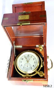
Instrument - Chronometer
... The maker, First Watch Factory, has a dept that is still producing the "8916" standard Chronometer for horologists and collectors. flagstaff hill warrnambool shipwrecked-coast flagstaff-hill flagstaff-hill-maritime-museum maritime-museum shipwreck-coast flagstaff-hill-maritime-village chonometer russian watch factory marine navigational instrument Inscription on box are in Russian & translate as follows: ХРОНОМЕТР, = CHRONOMETER МОРСКОЙ, = NAUTICAL ГОСТ, 8916-77 = Gost ЛОЛ ЕТ, on dial face = LOL ET Marine chronometer of Russian make in wooden case, metal handles on sides, inscription on a metal plaque on the front of the case. ...First State Watch Factory: This factory was founded in 1930 under orders from Joseph Stalin, the "First State Watch Factory" was the first large-scale Soviet watch and mechanical movement manufacturer in the USSR. Via its USA-based trading company (Amtorg), the Soviet government bought the defunct Ansonia Clock Company of Brooklyn, New York in 1929, and the "Dueber-Hampden Watch Company of Canton", based in Ohio. The soviets moved twenty-eight freight cars full of machinery and parts from the USA to Moscow in order to establish the factory. Twenty-one former "Dueber-Hampden" watchmakers, engravers and various other technicians helped to train the Russian workers in the art of watchmaking as part of the Soviet's first five-year plan. The movements of very-early products were still stamped "Dueber-Hampden, Canton, Ohio, USA" (examples of these watches are very collectible today). In 1935 the factory was named after the murdered Soviet official Sergei Kirov. During the second world war, as the Germans closed in on Moscow in 1941, the factory was hurriedly evacuated to (Zlatoust USSR). By 1943 the Germans were in retreat, and the factory was moved back to Moscow, adopting the "First Moscow Watch Factory" name. In 1947 the first wristwatches under the brand name "Pobeda" and the first Marine Chronometers and Deck watches were produced. By 1951 the production of wristwatches had increased to 1.1 million. In 1975 new machinery and equipment for manufacturing complex watches were imported from Switzerland. The first chronograph called "Okean" (3133) was produced for the space station "Soyuz-23."The Chronometer is of recent manufacture and an excellent example of the type of instrument used to navigate the seas in the 19th century. It is of good quality and of a type regarded as very accurate and well made. The maker, First Watch Factory, has a dept that is still producing the "8916" standard Chronometer for horologists and collectors. Marine chronometer of Russian make in wooden case, metal handles on sides, inscription on a metal plaque on the front of the case. Polished square wooden outer case with green felt lining and, a leather carrying strap and buckle. Outer case is hinged and has a metal latch on the front. Outer case has a red velvet covering with a button and loop closure. Inscription on box are in Russian & translate as follows: ХРОНОМЕТР, = CHRONOMETER МОРСКОЙ, = NAUTICAL ГОСТ, 8916-77 = Gost ЛОЛ ЕТ, on dial face = LOL ETflagstaff hill, warrnambool, shipwrecked-coast, flagstaff-hill, flagstaff-hill-maritime-museum, maritime-museum, shipwreck-coast, flagstaff-hill-maritime-village, chonometer, russian, watch factory, marine, navigational instrument -
 Flagstaff Hill Maritime Museum and Village
Book - Textbook, Introduction to Modern Geography
... His younger son William Thomson (1824-1907) became Professor of Natural Philosophy from 1846-1899 at the University of Glasgow, and later the 1st Baron of Kelvin, famous for his designs of nautical instruments such as the navigational compass and sounding equipment used in the transatlantic installation of sea cable. ...His younger son William Thomson (1824-1907) became Professor of Natural Philosophy from 1846-1899 at the University of Glasgow, and later the 1st Baron of Kelvin, famous for his designs of nautical instruments such as the navigational compass and sounding equipment used in the transatlantic installation of sea cable. ...This mid-19th century scientific reference book, Introduction to Modern Geography, explains geography and astronomy using the globe of the world as a teaching aid. The inscription connects this book to the Bobinawarrah Public Library but research to date has found no further details about the library. The rural area was settled in 1859, but in 2016 its population was only 87. It is situated about 21 kilometres south of the City of Wangaratta, in Northeast Victoria. In 2024 the local community received a grant for preservation of its almost 100-year-old Bobinawarrah Memorial Hall which displays an honour board of the Pioneers of Bobinawarrah 1859-1959. The donor of the book lived in Warrnambool. ABOUT THE AUTHOR, James Thomson (1786-1849): - James Thomson was a British Irish mathematician. He became Professor of Mathematics at the University of Glasgow. He wrote many school textbooks and reference books, one of which was Introduction to Modern Geography, first published in Belfast in 1827, and revised and published in over 20 more editions. Thomson tutored two of his several children at home. His older son James Thomson (1822-1892) became an engineer and physicist. His younger son William Thomson (1824-1907) became Professor of Natural Philosophy from 1846-1899 at the University of Glasgow, and later the 1st Baron of Kelvin, famous for his designs of nautical instruments such as the navigational compass and sounding equipment used in the transatlantic installation of sea cable. William was part of the firm that became famous as Kelvin & Hughes Ltd., suppliers of radar and echo sounders to the Ministry of Transport and the Ministry of Defence. The name continued on as Kelvin & Hughes. James Thomson (1786-1849) was a renowned British Irish mathematician and Professor of Mathematics at the University of Glasgow. He was a respected author of many important school books and textbooks that were widely used to provide understanding of arithmetic and geography. Thomson encouraged practical education and held extra classes for young ladies to learn mathematics and geography, which were a novelty at that time. Many of his works were known and used worldwide. This work was published in many editions. It is now considered as culturally significant as a basis for knowledge about our civilisation and has been made publicly available in overseas countries, and republished and reproduced in a readable format, including its diagrams and maps. Book; scientific textbook. The book has a black leather cover. The front cover is blank, but the spine has an embossed gold vertical title within a rectangular border boasting fancy corners. The fly page has a detailed title. The author is James Thomson. It is the Eighteenth edition, published in Simms & McIntyre of London and Belfast in 1845. An inscription connects it to the Bobinawarrah Public Library in Victoria.Spine within a gold border: "THOMSON'S GEOGRAPHY" Fly Page: "AN INTRODUCTION TO MODERN GEOGRAPHY, WITH AN APPENDIX, CONTAINING AN OUTLINE OF ASTRONOMY, AND THE USE OF THE GLOBES. BY JAMES THOMSON, LL.D., PROFESSOR OF MATHEMATICS IN THE UNIVERSITY OF GLASGOW." "Eighteenth Edition" "LONDON: SIMMS AND McINTYRE, ALDINE CHAMBERS, PATERSOSTER ROW; AND DONEGALL -STREET, BELFAST.""1845"flagstaff hill, flagstaff hill maritime museum and village, warrnambool, maritime museum, maritime village, great ocean road, shipwreck coast, introduction to geography, james thomson, reference book, professor thomson's introduction to modern geography, bobinawarrah public library, james thomson mathematician, james thomson engineer, 19th century irish mathematician, irish presbyterian, william thomson 1st baron of kelvin, professor of mathematics, glasgow university, william thomson professor of natural philosophy, introduction to modern geography, outline of astronomy, use of the globes, james thomson ll.d., simms and mcintyre, 1843, scientific book, school book, lord kelvin, baron kelvin of langs, nautical instruments, marine instruments, transatlantic cable, kelvin & hughes, thomson’s geography, astronomy, geography, world globe, cartography, pioneers of bobinawarrah, textbook -
 Mission to Seafarers Victoria
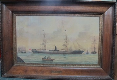
Painting, George Frederick Gregory (1821-1887), P&O S.S. Bangalore, 1867 - 1886
... nautical pictures was organised at the Central Mission on 2 April 1948. The painting may have been purchased during one of these two events. s.s. bangalore marine painting sailing ships 1867 william denny artwork-paintings peninsular and oriental steam navigation company steamship p&o sandridge port melbourne hobson's bay charles dickson gregory centenary maritime exhibition george frederick gregory (1821-1887) ss bangalore Painted in black on plaque and coloured black: "P & O S.S. ...This ship was number 1 of 2 ships named Bangalore and run by P & O. This ship has listed the same tonnage as that on the inscription on the frame of this work. The ship was subsequently sold in 1886 sold to Hajee Cassum Joosub and used for passengers on pilgrimage into Jeddah. Another view of the history of the Bangalore is that to be found at the Maritime Museums of Sydney listing of another painting of the Bangalore which provides a somewhat different history. It is possible that the story of Bangalore 1 and Bangalore 2 have become conflated further research is needed to verify. see Links field. SS BANGALORE was built in 1867 by William Denny of Dumbarton. Owned by P&O, SS BANGALORE operated from Bombay and Galle to Melbourne and Sydney from 1872 to 1886 as a passenger and mail ship. In 1891 BANGALORE was sold to Wilh. Wilhelmsen, Norway and renamed SS CORINGA.Marine art, Maritime artP&O S.S. Bangalore by George Frederick Gregory (1821-1887)Thinly painted image on board featuring centrally a moored, at anchor, 19th C dual masted steamship with black funnel and flying at the stern a red ensign. To either side are conventional rigged clippers or sailing ships. Near the bow of the steamship there seems to be a tug or paddle steamer face on. In the foreground is a small rowing boat with boatman and two passengers, a male and a female. The painting on board is mounted in a large polished or varnished cedarwood frame with edge carving and a decorative pitted slip which holds in place a thin piece of glazing. Backing paper and seal has all been removed except for hanging wire. Central at front lower edge of frame is a small chipped wood plaque with inscription.Painted in black on plaque and coloured black: "P & O S.S. "BANGALORE" / 2342 tons Built 1867"s.s. bangalore, marine painting, sailing ships, 1867, william denny, artwork-paintings, peninsular and oriental steam navigation company, steamship, p&o, sandridge, port melbourne, hobson's bay, charles dickson gregory, centenary maritime exhibition, george frederick gregory (1821-1887), ss bangalore -
 Mission to Seafarers Victoria
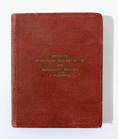
Book - Manual, J. McKerrell, Brown's Practical Pocket-Book for Merchant Seamen, 1946
... He served on these ships: SS Corinda SS Macumba SS Mildura SS Nellor SS Ormiston SS Reynella anne rennie collection wal harbord merchant navy seamen seafarers ww2 battle of the atlantic walter harbord navigation Pocket book with red cover; 292 pages Brown's Practical Pocket-Book for Merchant Seamen Book Manual J. McKerrell Brown, Son and Ferguson, Limited, Nautical Publishers ...Pocket book with red cover; 292 pagesnon-fictionanne rennie collection, wal harbord, merchant navy, seamen, seafarers, ww2, battle of the atlantic, walter harbord, navigation -
 Mission to Seafarers Victoria
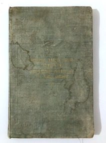
Book - Manual, James Gordon, AM, Nautical Marine Board Examination-Preparatory Instruction, 1849
... He served on these ships: SS Corinda SS Macumba SS Mildura SS Nellor SS Ormiston SS Reynella anne rennie collection wal harbord merchant navy seamen seafarers ww2 battle of the atlantic walter harbord navigation Name pencilled at the back of the cover. Small book with green cloth cover; 100 pages Nautical Marine Board Examination-Preparatory Instruction Book Manual James Gordon, AM ...Small book with green cloth cover; 100 pagesnon-fictionanne rennie collection, wal harbord, merchant navy, seamen, seafarers, ww2, battle of the atlantic, walter harbord, navigation -
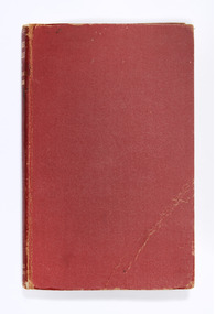 Nhill Aviation Heritage Centre
Book - Reference Book, Hughes' Tables for Sea and Air Navigation, 1938
... Nautical Almanac Office Red with gold lettering on spine Hughes' Tables for Sea and Air Navigation Book Reference Book L.J.Comrie ...Red with gold lettering on spinenon-fiction -
Federation University Historical Collection
Book, William Collins, Sons, & Company, Elementary Treatise on Nautical Astronomy for the Use of Science Classes and Seamen, 1873, 1873
... henry evers navigation chronometer astronomy index error vernier meridian elementary school science class sextant zodiac sailing numbers marked in pencil on page 144 Small book with dark green embossed fabric hard cover with 144 pages Elementary Treatise on Nautical Astronomy for the Use of Science Classes and Seamen, 1873 Book Book William Collins, Sons, & Company ...Small book with dark green embossed fabric hard cover with 144 pagesnon-fictionhenry evers, navigation, chronometer, astronomy, index error, vernier, meridian, elementary school, science class, sextant, zodiac, sailing -
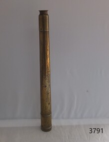 Flagstaff Hill Maritime Museum and Village
Instrument - Marine Telescope, 1870-1880
... nautical instruments. John Browning's great-grandfather was also an instrument maker as well as John’s brother Samuel Browning of the firms Spencer & Browning and Spencer, Browning & Rust, who also manufactured navigational instruments. ...nautical instruments. John Browning's great-grandfather was also an instrument maker as well as John’s brother Samuel Browning of the firms Spencer & Browning and Spencer, Browning & Rust, who also manufactured navigational instruments. ...This telescope was amongst various items collected from a sea dive in Port Phillip Bay. The diver was the caretaker of the Port Lonsdale Lighthouse, who dived on various wrecks in the bay during the 1960's. After the caretaker's death, his son sold off many of the shipwreck artefacts. The telescope was purchased from the caretaker's son in the 1990's by a previous owner of the Marine Shop, Queenscliff, Victoria. John Browning was particularly well known for his scientific advances in the fields of spectroscopy, astronomy, and optometry. Between 1856 and 1872, Browning acquired provisional patents for designs of numerous scientific instruments. He was also the recipient of an award at the 1862 International Exhibition held in London. Also recognised for his temperature-compensated aneroid barometer. Browning's scientific instruments were used in physics, chemistry, and biology. The products he designed and manufactured included spectroscopes, telescopes, microscopes, barometers, photometers, cameras, ophthalmologist, and electrical equipment such as electric lamps. John Browning was born around 1831 in Kent, England. His father, William Spencer Browning, was a maker of nautical instruments. John Browning's great-grandfather was also an instrument maker as well as John’s brother Samuel Browning of the firms Spencer & Browning and Spencer, Browning & Rust, who also manufactured navigational instruments. The latter firm was in operation in London from 1784 to 1840 and was succeeded by the firm of Spencer, Browning & Co. John Browning initially intended to follow the medical profession and entered Guy's Hospital, a teaching hospital and a school of medicine. Despite having passed the required examinations, however, he abandoned his plans. Instead, he apprenticed with his father, William Spencer Browning. At the same time, in the late 1840s, he was a student attending the Royal College of Chemistry several days per week. By the early 1870s, practical optics had become John Browning's primary interest, and he listed his occupation as an optician on the census records from 1871 to 1901. He was well known among London's ophthalmic surgeons for his various ophthalmic instruments. He had a large part in reforming the art of crafting spectacles. Other achievements were as an author of the book, How to Use Our Eyes and How to Preserve them by the Aid of Spectacles. Published in 1883, the book included thirty-seven illustrations, including a diagram demonstrating the anatomy of the eye. In 1895, he was one of the founders of the "British Ophthalmology" the first professional organisation for optometry. He was not only its first president but also registered as its first member so many considered him to be the first professional optometrist. Other professional organisations he belonged too was as a member of “The Aeronautical Society of Great Britain”. In 1871 constructing the first wind tunnel located at Greenwich Marine Engineering Works. He was also a member of other scientific organisations, such as the “Microscopical Society of London”, the “Meteorological Society”, and the “Royal”. Then in 1908 the company of W. Watson & Son, opticians and camera makers, took over John Browning's company since 1901 John Browning had been semi-retired but in 1908 he fully retired and moved to Bournemouth in Hampshire. He died in Cheltenham, Gloucestershire in 1925.The telescope is significant for its association with one of the world’s leading scientific instrument makers and inventor of the 19th and early 20th century. It is believed the donation came off a wreck either in Port Philip Bay or between Point Lonsdale and the Nepean Heads making it a significant maritime historical artefact. Its provenance is good given it was taken off a wreck in this area by the Point Lonsdale lighthouse caretaker. Examples of John Browning's telescopes because of their scientific and historical importance are highly valued by collectors.Marine style single draw brass telescope with a sunshade. The single draw has no split and the second cartridge is held in a long brass tube within the single draw, mounted from the objective end. The eyepiece is flat and at the end of the first draw in a very faded engraving that is believed to read "John Browning, 63 Strand, and should read London under the word strand but this is hard to establish given the engravings condition. This interpretation of the engraving has been arrived at by examination of other John Browning telescope engraving examples."John Browning, engraved to the first tube in copper plate style "63 STRAND" Engraved under in capital textflagstaff hill, flagstaff hill maritime museum and village, warrnambool, maritime museum, maritime village, great ocean road, shipwreck coast, shipwreck artefact, port phillip bay, port lonsdale lighthouse, wreck, 1960’s diver, queenscliff marine shop, john browning, telescope, spectroscopy, optometry, scientific instruments, william spencer browning, optician, navigational instrument, microscopical society of london, aeronautical society, marine technology -
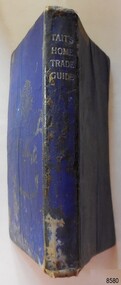 Flagstaff Hill Maritime Museum and Village
Book - Technical Reference, James Tait, Extra Master and Author et al, Tait's Home Trade Guide to the Board of Trade Examinations for Mates and Masters, 1943
... navigation exams...Ship's Mate...Ship's Master...WWII textbook...nautical...The book includes navigational information, tables and maps, diagrams and formulas. It was written for Examiners and Students studying for their nautical Mates and Masters marine qualifications— notes have been handwritten inside the front and back covers. ...Jefferys, Extra Master Printed by Nautical Press, Brown, Son & Ferguson, Limited, 52-58 Darnley Street, Glasgow Hardcover, small book, royal blue cover, silver embossed text on spine. Textbook for Mariners. Includes tables and maps, diagrams and formulas, and navigational...It is an aid to understanding the navigational methods of the time and the changes and improvements in more recent history. flagstaff hill warrnambool shipwrecked coast flagstaff hill maritime museum maritime museum shipwreck coast flagstaff hill maritime village great ocean road james tait brown, son and ferguson limited torpedo open fire pt welch vessel gascoyne e-boat u-boat marine technology World War II WWII WW2 navigation exams Ship's Mate Ship's Master WWII textbook nautical textbook navigational textbook examination textbook World War II textbook 1943 nautical textbook Spint, in silver embossing "TAIT'S HOME TRADE GUIDE" Handwritten inside the back cover "R.A.D. / MOORE / PT. ...The book includes navigational information, tables and maps, diagrams and formulas. It was written for Examiners and Students studying for their nautical Mates and Masters marine qualifications— notes have been handwritten inside the front and back covers. Notes in point form: 1. I have seen the back of a torpedo EBoat or UBoat in my starboard side 2. I _ _ _ to - - - - - - - - - Port side 3. at a distance ----------- 4. Enemy surface vessel in sight __________ 5. suspicious vessel in sight 6. enemy (undecipherable) 7. I have cut a _ _ _ adrift with my _ _ 8. FI_ _ WISE _ _ _ 9. STARWISE 0. OPEN FIREThis relatively rare book provided up-to-date navigational information during World War II. It was to be used by Examiners to assess whether students qualified to be a Ship's Mate or Ship's Master. The contents of the book were based on maritime knowledge gained over centuries. It is an aid to understanding the navigational methods of the time and the changes and improvements in more recent history.Title: Tait's Home Trade Guide: to the Board of Trade Examinations for Mates and Masters Author: James Tait, Extra Master Publisher: Brown, Son and Ferguson, Ltd. Glasgow, Great Britain Date: Revised Edition 1943 Further Information: Fourteenth Edition 1941, Reprinted Edition 1943. Revised and brought up to date by Captain H. T. Jefferys, Extra Master Printed by Nautical Press, Brown, Son & Ferguson, Limited, 52-58 Darnley Street, Glasgow Hardcover, small book, royal blue cover, silver embossed text on spine. Textbook for Mariners. Includes tables and maps, diagrams and formulas, and navigational information. The inside covers of this book contain handwritten calculations, diagrams and notes that refer to navigation. Notes inside the back cover refer to an enemy vessel and OPEN FIRE.Spint, in silver embossing "TAIT'S HOME TRADE GUIDE" Handwritten inside the back cover "R.A.D. / MOORE / PT. WELCH" Included with the text inside the back cover "Gascoyne" "506" and "RCM"flagstaff hill, warrnambool, shipwrecked coast, flagstaff hill maritime museum, maritime museum, shipwreck coast, flagstaff hill maritime village, great ocean road, james tait, brown, son and ferguson limited, torpedo, open fire, pt welch, vessel gascoyne, e-boat, u-boat, marine technology, world war ii, wwii, ww2, navigation exams, ship's mate, ship's master, wwii textbook, nautical textbook, navigational textbook, examination textbook, world war ii textbook, 1943 nautical textbook
