Showing 92 items matching "navigate"
-
 Flagstaff Hill Maritime Museum and Village
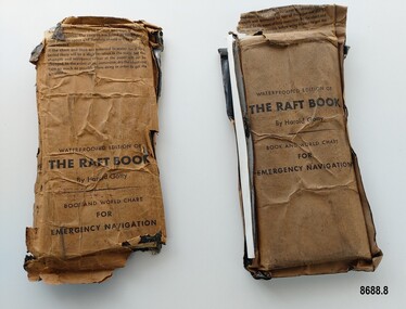
Booklet - Book and World Chart for Emergency Navigation, George Grady Press, The Raft Book, 1943
... In 1943 he moved to Washington where he developed a survival book (The Raft Book) specifically for boat crews or air crews flying over the Pacific to help them survive and navigate their life rafts in remote areas of the ocean. ...Each packet contains a folded 64 page paper booklet with detailed instructions for navigating a small craft in open seas, a folded chart (with a map of the world and oceans, well known constellations, latitude and longitude charts, Greenwich time and a scale for string lengths and Harp scale) and a long folded paper calendar strip....Take the following pre/cautions for your own safety:/ Carry a good type of pocket watch / keep it wound and have it running on Greenwich (England) / Time, which you can get from the navigating officer. / Keep track of the date at Greenwich; and on a 24-hour basis, / know whether the time is, say, 6 hours (6 A.M.) showing on / your watch, or 18 hours (6P.M.) ...In 1943 he moved to Washington where he developed a survival book (The Raft Book) specifically for boat crews or air crews flying over the Pacific to help them survive and navigate their life rafts in remote areas of the ocean. ...Harold Gatty was born on January 5th, 1903 in Campbell Town, Tasmania. He was a navigator and aviation pioneer. He began his career learning navigation at the age of 14 as a midshipman at the Royal Australian Naval College but withdrew after three years and became an apprenticed ship's officer with the Patrick Steamship Company of Sydney. After W. W. 1 he joined the Australian Merchant Navy where he learned the constellations while standing night watch and became an expert in celestial navigation while serving on many ships sailing between Australia and California. In 1927 he moved to California and opened a navigation school and also a laboratory repairing navigational equipment. At this time he became very interested in air navigation and was aware of the limitations of existing methods and instruments for aerial navigation. He began researching ways of improving aerial navigation. Two early inventions of his were his air sextant and a ground speed and drift indicator which formed the basis of the automatic pilot which later came to be standard equipment on most aircraft. He worked with several record breaking pilots including Ann Morrow Lindbergh (who went on to serve as a navigator for her husband Charles Lindbergh), helped Wiley Post break the world record circumnavigating the Earth, invented a new method of "dead reckoning" that revolutionised the ability to fly safely through cloudy conditions without drifting off course and famously navigated a small plane (whilst trying to cross the Pacific) over 1900 km through fog (with no radio) and using only his dead reckoning techniques, back to their starting point in Japan after they developed fuel problems. In 1932 Gatty received the Distinguished Flying Cross from President Hoover. In 1934 Gatty formed the South Seas Commercial Company with Donald Douglas with the aim to deliver air services to the islands of the South Pacific. The Company was sold to Pan Am but he continued to work for them. In 1935 he went on a sailing expedition investigating several small islands in the South Pacific and was briefly marooned on Baker Island. He was able to use his extensive knowledge of seabird habits to save the crew. He was also very interested in the ability of the Polynesians to navigate using the stars. During the Second World War Gatty was given the honorary rank of Group Captain in the Royal Australian Air Force (RAAF) and worked for the U. S. Army Air Forces (USAAF) in the South Pacific. In 1943 he moved to Washington where he developed a survival book (The Raft Book) specifically for boat crews or air crews flying over the Pacific to help them survive and navigate their life rafts in remote areas of the ocean. The original book was 152 pages long however a condensed version was made which consisted of a 64 page booklet, combined map and star chart and calendar strip enclosed in a waterproof slipcase, to be placed in life rafts for emergency use. The booklet included navigational advice and ideas such as ocean currents, estimation of distance, using a compass, measurement of angles, recognising and steering by the stars, land indications from sea birds, migration of sea birds and insects, sounds from the land, the scent of the land and ocean currents and the colour of the sea etc. After W.W.2 Gatty moved to Fiji and formed Fiji Airways (which later became Air Pacific). Harold Gatty died in August 1957.The two copies of "The Raft Book" are significant as they are a written summary of the many methods of sea navigation (both modern and historical) that existed in the 1940's. They are also a record of Harold Gatty, who played a significant role in the development of modern day aerial navigation using his understanding of different sea navigational techniques.Two rectangular brown packets with waterproof coverings (oiled paper) titled "The Raft Book" by Harold Gatty. Each packet contains a folded 64 page paper booklet with detailed instructions for navigating a small craft in open seas, a folded chart (with a map of the world and oceans, well known constellations, latitude and longitude charts, Greenwich time and a scale for string lengths and Harp scale) and a long folded paper calendar strip.Front of package - "WATERPROOFED EDITION OF/ THE RAFT BOOK / By Harold Gatty / BOOK AND WORLD CHART / FOR / EMERGENCY NAVIGATION / To open envelope tear along above line. If the envelope is used again fold the flap to keep contents dry. 1. This envelope contains a book, chart and tape for emergency navigation. The contents are folded to take up the least possible space and therefore should not be removed until needed. 2. if the chart and tape are immersed in water for a long period, there will be a slight variation in the scale but the strength and resistence to tear of the paper will not be changed. In the event of long immersion, dry the chart and tape as much as possible before using in order to in order to get the greatest accuracy in scale. Front of booklet - THE RAFT BOOK / LORE OF THE SEA AND SKY /By Harold Gatty IMPORTANT FOR YOUR SECURITY/Upon abandoning ship you may have to be your own navigator. Take the following pre/cautions for your own safety:/ Carry a good type of pocket watch / keep it wound and have it running on Greenwich (England) / Time, which you can get from the navigating officer. / Keep track of the date at Greenwich; and on a 24-hour basis, / know whether the time is, say, 6 hours (6 A.M.) showing on / your watch, or 18 hours (6P.M.) Greenwich. / PROECT YOUR WATCH. GET A RUBBER SACK FOR IT (OBTAIN FROM PHARMACIST) AND KEEP IT DRY / KEEP A PENCIL IN YOUR POCKET/ POSITION OF SHIP WHEN ABANDONED PRINTED IN UNITED STATES OF AMERICA GEORGE GRADY PRESS, NEW YORK/COPYRIGHT, 1943, BY HAROLD AND FENNA GATTYflagstaff hill maritime museum and village, shipwreck coast, warrnambool, the raft book, harold gatty, book and world chart for emergency navigation, ww 2, ww ii, navigation, air navigation, aerial navigation, lindbergh, wiley post, dead reckoning, south seas commercial company, u.s. army airforce, usaaf, survival book, life rafts, sea navigation, emergency navigation, fiji airways, harp scale -
 Vision Australia
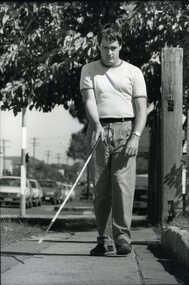
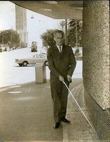
Photograph - Image, Man using white cane on the footpath, 1988
... A mid-twenties male uses a white cane to navigate a footpath on a busy road....Vision Australia 454 Glenferrie Road Kooyong melbourne A mid-twenties male uses a white cane to navigate a footpath on a busy road. Royal Blind Society of New South Wales White Cane Day Orientation and mobility File: Skills Training - O&M A white cane provides blind people with early warning of obstacles. ...A mid-twenties male uses a white cane to navigate a footpath on a busy road.1 x B/W photograph of man using white caneFile: Skills Training - O&M A white cane provides blind people with early warning of obstacles. Using a white cane for mobility.royal blind society of new south wales, white cane day, orientation and mobility -
 National Vietnam Veterans Museum (NVVM)
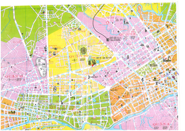
Map - Saigon Map
... This map was used by personnel to navigated around the city of Siagon and suburbs during the conflict in Vietnam between 1962 to 1973....National Vietnam Veterans Museum (NVVM) 25 Veterans Drive Newhaven phillip-island-and-the-bass-coast This map was used by personnel to navigated around the city of Siagon and suburbs during the conflict in Vietnam between 1962 to 1973. ...This map was used by personnel to navigated around the city of Siagon and suburbs during the conflict in Vietnam between 1962 to 1973.A coloured map of Saigon City or part thereof. Map divided into colour coded quadrants whit white coloured roads dissecting areas/suburbs.map, saigon, simms, peter sims oam jp, vietnam, street -
 Vision Australia
Image
... RBS client and worker, Michael Simpson, uses his white cane to navigate the balcony at the RBS offices in Enfield....Vision Australia 454 Glenferrie Road Kooyong melbourne RBS client and worker, Michael Simpson, uses his white cane to navigate the balcony at the RBS offices in Enfield. ...RBS client and worker, Michael Simpson, uses his white cane to navigate the balcony at the RBS offices in Enfield.B/W photographMichael Simpsonwhite cane day, royal blind society of new south wales, michael simpson -
 Vision Australia
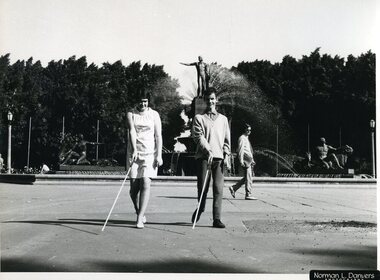
Photograph - Image, Navigating the Archibald Fountation, 1970?
... A young lady and man use white canes to navigate Hyde Park North in Sydney, in front of the Archibald fountain....Vision Australia 454 Glenferrie Road Kooyong melbourne A young lady and man use white canes to navigate Hyde Park North in Sydney, in front of the Archibald fountain. ...A young lady and man use white canes to navigate Hyde Park North in Sydney, in front of the Archibald fountain.B/W photograph of two people using canes10/70103 M&O - Historical Mobility - historicalroyal blind society of nsw, white cane day -
 Vision Australia
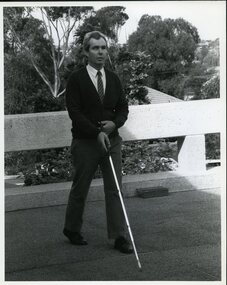
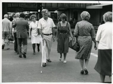
Photograph - Image, Frank Knox crossing a busy road with Lori Lerner watching his cane technique, 1986
... RBS client Frank Knox navigates his way along Sydney's footpaths with O&M instructor Lori Lerner....Vision Australia 454 Glenferrie Road Kooyong melbourne RBS client Frank Knox navigates his way along Sydney's footpaths with O&M instructor Lori Lerner. ...RBS client Frank Knox navigates his way along Sydney's footpaths with O&M instructor Lori Lerner.B/W photograph of man using a white canePhoto for page No. 11 - 1986 Use this for circle photo's.royal blind society of nsw, white cane day, frank knox, lori lerner -
 Vision Australia
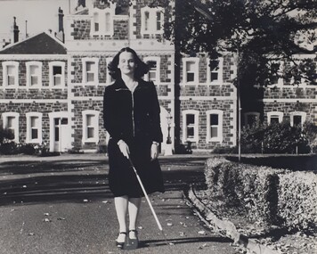
Photograph (item) - Image, Walking along RVIB driveway
... A young woman navigates her way along the driveway outside RVIB, keeping clear of the hedged garden border to her left....Vision Australia 454 Glenferrie Road Kooyong melbourne A young woman navigates her way along the driveway outside RVIB, keeping clear of the hedged garden border to her left. royal victorian institute for the blind orientation and mobility Black and white photograph of person using white cane on a driveway Walking along RVIB driveway Photograph Image ...A young woman navigates her way along the driveway outside RVIB, keeping clear of the hedged garden border to her left.royal victorian institute for the blind, orientation and mobility -
 Seaworks Maritime Museum
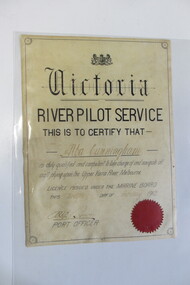
Certificate, 12/02/1912
... "Victoria/ River Pilot Service/ This is to certify that/ Alba Cunnigham/ is duly qualified and competent to take charge and navigate all/ craft plying upon the Upper Yarra River Melbourne/ Licence issued under the Marine Board/ This twelfth day of February 1912/ Port Officer" written with pencil on the back "7.06" ...Seaworks Maritime Museum 82 Nelson Place Williamstown melbourne "Victoria/ River Pilot Service/ This is to certify that/ Alba Cunnigham/ is duly qualified and competent to take charge and navigate all/ craft plying upon the Upper Yarra River Melbourne/ Licence issued under the Marine Board/ This twelfth day of February 1912/ Port Officer" written with pencil on the back "7.06" A4 sized certificate with a black border and red seal. ...A4 sized certificate with a black border and red seal. "Victoria/ River Pilot Service/ This is to certify that/ Alba Cunnigham/ is duly qualified and competent to take charge and navigate all/ craft plying upon the Upper Yarra River Melbourne/ Licence issued under the Marine Board/ This twelfth day of February 1912/ Port Officer" written with pencil on the back "7.06" -
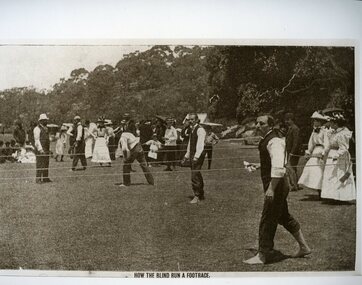 Vision Australia
Photograph - Image, Historical footrace
... Competitors held cloths to prevent their hands from the friction as they navigated the course without canes or a guide. ...Competitors held cloths to prevent their hands from the friction as they navigated the course without canes or a guide. ...An image from a footrace that was held for blind individuals, using ropes as guide lines. Competitors held cloths to prevent their hands from the friction as they navigated the course without canes or a guide. Copy of a sepia toned photograph of footrace trackroyal blind society of nsw, recreation -
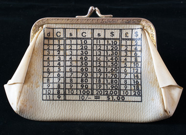 Brighton Historical Society
Purse, Coin purse, circa 1966
... This coin purse is printed with a simple conversion table to help the user navigate the switch from pounds, shillings and pence to the new dollars and cents....This coin purse is printed with a simple conversion table to help the user navigate the switch from pounds, shillings and pence to the new dollars and cents. coin purse decimal currency 1960s Cream vinyl coin purse with conversion table for pre-decimal and decimal currency printed in black on each side. ...Australia converted to decimal currency on 14 February 1966. This coin purse is printed with a simple conversion table to help the user navigate the switch from pounds, shillings and pence to the new dollars and cents.Cream vinyl coin purse with conversion table for pre-decimal and decimal currency printed in black on each side. Hinged silver metal opening and kiss clasp. Unlined.coin purse, decimal currency, 1960s -
 Hume City Civic Collection
Print - Street Directory, Gregory"s Melbourne Street Directory, c1972
... It was used by the donor's family for many years to navigate their way around Melbourne and the metropolitan area. ...It was used by the donor's family for many years to navigate their way around Melbourne and the metropolitan area. ...This street directory was published by Gregory's Guides & Maps Pty Ltd of 142 Clarence Street, Sydney NSW in c1972. It was used by the donor's family for many years to navigate their way around Melbourne and the metropolitan area. A street directory enclosed in a black leather detachable cover with gold embossing of a car on the front cover.Gold embossed vintage car on front of detachable cover.joan houston, streets, roads, maps, street directory -
 Vision Australia
Photograph - Image, Richard Carbone and Mal Fraser, October 2007
... Images taken of schoolboy Richard Carbone, who worked with Orientation and Mobility Instructor Malcolm Fraser to successfully navigate the escalators at Maribyrnong shopping centre (Highpoint?) ...Vision Australia 454 Glenferrie Road Kooyong melbourne Images taken of schoolboy Richard Carbone, who worked with Orientation and Mobility Instructor Malcolm Fraser to successfully navigate the escalators at Maribyrnong shopping centre (Highpoint?) ...Images taken of schoolboy Richard Carbone, who worked with Orientation and Mobility Instructor Malcolm Fraser to successfully navigate the escalators at Maribyrnong shopping centre (Highpoint?) One image reproduced in 2007-8 Annual Report.16 digital images of Richard Carbone and Mal Fraservision australia, richard carbone, malcolm fraser, orientation and mobility -
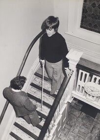 Vision Australia
Photograph (item) - Image, Moving around RVIB
... A young person navigates their way down a staircase inside the RVIB building at St Kilda Road. ...Vision Australia 454 Glenferrie Road Kooyong melbourne A young person navigates their way down a staircase inside the RVIB building at St Kilda Road. ...A young person navigates their way down a staircase inside the RVIB building at St Kilda Road. Ahead of them, a male staff member stands, verbally guiding them in using their cane to find the next steps.royal victorian institute for the blind, orientation and mobility -
 Vision Australia
Photograph - Image, Michael Yanchenock walking around Sydney, 1969
... Michael Yanchenock uses his white cane to navigate around the side of a building in Sydney both alone and with mobility instructor Margit Rihr. ...Vision Australia 454 Glenferrie Road Kooyong melbourne Michael Yanchenock uses his white cane to navigate around the side of a building in Sydney both alone and with mobility instructor Margit Rihr. ...Michael Yanchenock uses his white cane to navigate around the side of a building in Sydney both alone and with mobility instructor Margit Rihr. These pictures were taken near the William Street/Boomerang Street building of RBS.2 x Sepia toned photograph of orientation and mobility training1-1769 Michael Mobility training Oct 1969 Photographic Illustrators, Double Bay 2-1769 Photographic Illustrators, Double Bay - 36-1764. Margit Rihr & Michael Yanchenock - mobility training October 1969, Mobility - historicalroyal blind society of nsw, white cane day, orientation and mobility, michael yanchenock, margaret rihr -
 Eltham District Historical Society Inc
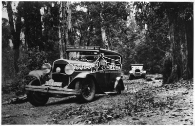
Photograph, Goodwood Powelltown Melbourne Daily
... Two cars, probably 1929 Chryslers navigate the forest track probably Kinglake National Park. ...Eltham District Historical Society Inc 728 Main Rd Eltham melbourne Two cars, probably 1929 Chryslers navigate the forest track probably Kinglake National Park. ...Two cars, probably 1929 Chryslers navigate the forest track probably Kinglake National Park. Front vehicle has sign: "Goodwood Powelltown Melbourne daily". Photo sourced from the Forests Commission of Victoria. Ref. JJ 399This photo forms part of a collection of photographs gathered by the Shire of Eltham for their centenary project book,"Pioneers and Painters: 100 years of the Shire of Eltham" by Alan Marshall (1971). The collection of over 500 images is held in partnership between Eltham District Historical Society and Yarra Plenty Regional Library (Eltham Library) and is now formally known as the 'The Shire of Eltham Pioneers Photograph Collection.' It is significant in being the first community sourced collection representing the places and people of the Shire's first one hundred years.Digital imagesepp, shire of eltham pioneers photograph collection, kinglake, goodwood powelltown melbourne daily, automobile, chrysler, kinglake national park, forest track -
 Lakes Entrance Historical Society
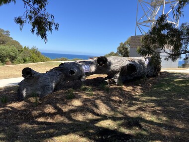
Photograph - Jemmys Point Lookout Tree Memorial Lakes Entrance November 2024
... The lookout tree at Jemmys Point was used for navigating entry to the Gippsland Lakes when the entrance was opened in 1889. ...The lookout tree at Jemmys Point was used for navigating entry to the Gippsland Lakes when the entrance was opened in 1889. ...The lookout tree at Jemmys Point was used for navigating entry to the Gippsland Lakes when the entrance was opened in 1889. After standing erect for hundreds of years it fell down in November 2024. The Shire Council quickly memorialised the fallen tree into a garden setting. Colour photograph of the Lookout Tree Memorial at Jemmys Point Kalimna Victoriamemorials, navigation, flora -
 Queenscliffe Maritime Museum
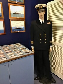
Uniform - Uniform Merchant Marine Officer
... Queenscliff and Point Lonsdale offer a great vantage point for ship spotting as they navigate the rip. The Museum has a large collection of paintings of ocean liners of the past which is of great interest to immigrants to this country especially those who travelled by sea in the past. ...Queenscliff and Point Lonsdale offer a great vantage point for ship spotting as they navigate the rip. The Museum has a large collection of paintings of ocean liners of the past which is of great interest to immigrants to this country especially those who travelled by sea in the past. ...The merchant marine has many followers in the area both past and present. Queenscliff and Point Lonsdale offer a great vantage point for ship spotting as they navigate the rip. The Museum has a large collection of paintings of ocean liners of the past which is of great interest to immigrants to this country especially those who travelled by sea in the past. Of significant interest to visitors who visit our display of ocean liners paintings. Migrants from the 50s to the 70s take great pleasure in finding their ship in the display. Unfortunately, nothing is know of the previous owner of the uniform.Chief engineer uniform on mannequin. Rank shown is that of Captain as the Chief Engineer was of equal rank to the Captain. However, the Captain retained overall authority on board ship. Uniform consists of cap, cap insignia, jacket, tie, trousers and additional two cap insignia and one shoulder insignia stored separately. [shirt and shoes shown are props] merchant marine, uniforms, insignia -
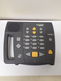 Vision Australia
Equipment - Object, Humanware, Victor Classic DAISY player
... The Victor Reader Classic used simple features that made it easy for clients to navigate through a book or magazine. The player played both DAISY and music CDs. ...The Victor Reader Classic used simple features that made it easy for clients to navigate through a book or magazine. The player played both DAISY and music CDs. ...With the advent of audio content available through i-phones and other small devices, the demand for a dedicated audio, easily portable player for the blind and vision impaired became louder and louder. Two organisations competed to deliver this and Canadian company Humanware developed the Victor Classic as a table top player that relied on discs. As CDs had been introduced into the library some years before, this allowed borrowers to have the advantages of 4 track cassettes within a digital medium. The Victor Reader Classic used simple features that made it easy for clients to navigate through a book or magazine. The player played both DAISY and music CDs. The function keys included controls for variable tone, volume, speed and creation of bookmarks, sleep time and you could navigate by chapter and page on DAISY books. A carry handle is included for ease of use.Grey square object with buttons for navigational controlsaudio equipment, assistive devices -
 Vision Australia
Photograph (item) - Image, Using support services
... Providing more than education or employment, blind and low vision organisations recognised that many people needed assistance in navigating paper forms to access support from the government. ...Vision Australia 454 Glenferrie Road Kooyong melbourne Providing more than education or employment, blind and low vision organisations recognised that many people needed assistance in navigating paper forms to access support from the government. ...Providing more than education or employment, blind and low vision organisations recognised that many people needed assistance in navigating paper forms to access support from the government. In these photographs a woman from RVIB helps a man fill in the paperwork required for the Invalid Pension. A brochure for this is situated on the corner of the coffee table that the forms rest on. The man sits between the woman and a television.royal victorian institute for the blind -
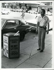 Vision Australia
Photograph - Image, Man using white cane and sonic guide
... A bearded man uses a white cane and sonic guide to help him navigate around the streets of Strathfield. ...Vision Australia 454 Glenferrie Road Kooyong melbourne A bearded man uses a white cane and sonic guide to help him navigate around the streets of Strathfield. The sonic guide consists of a pair of heavy black spectacles with three sensors built into the bridge of the glasses. ...A bearded man uses a white cane and sonic guide to help him navigate around the streets of Strathfield. The sonic guide consists of a pair of heavy black spectacles with three sensors built into the bridge of the glasses. The glasses are attached by a cable to a control box which is designed to be clipped onto the wearer's belt or clothing. The control box has two switches and a volume setting, and assists the user in determining objects in their path and their distance to them.2 B/W photographs of man using sonic guide and white cane"5156-220" and '5156-224" on back of photographsroyal blind society of nsw, white cane, orientation and mobility -
 Musculoskeletal Health Australia (now held by the Glen Eira Historical Society)
Photograph - Group photo, 1987
... Geoff found the support group very helpful in navigating the challenges of living with arthritis. ...Geoff found the support group very helpful in navigating the challenges of living with arthritis. ...In 1987, the Arthritis Foundation of Victoria started a support group for young adults with arthritis. This photo depicts Geoff and Julie Donald. Geoff found the support group very helpful in navigating the challenges of living with arthritis. The photo accompanies an article titled, "Young Adults Group key to Geoff's new attitude to arthritis". The photo and article appear on page 16 of the No 44, June 1987 issue of the Arthritis Foundation of Victoria's quarterly newsletter, News Review.Black and white photo of a man and a woman outdoors. He has one arm around her shoulders, and they are both smiling. They are both wearing t-shirts with text and a graphic design. Behind them, there are several large trees in a park across an empty road.arthritis foundation of victoria, afv, young adults, arthritis support group, self help groups, geoff donald, julie donald, news review, 1987 -
 Vision Australia
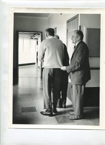
Photograph - Image, Three men walking along a corridor, 1970-1980s
... In the intersection of corridors at a nursing home, three men navigate their way along. The first man has only his lower half and back showing but appears to be guiding his companions. ...Vision Australia 454 Glenferrie Road Kooyong melbourne In the intersection of corridors at a nursing home, three men navigate their way along. The first man has only his lower half and back showing but appears to be guiding his companions. ...In the intersection of corridors at a nursing home, three men navigate their way along. The first man has only his lower half and back showing but appears to be guiding his companions. The middle man, dressed in a jumper, shirt, pants and polished shoes walks to his outer left, possibly holding the elbow of the man in front of him. The last man, wearing a jacket, shirt, tie, pants and a pair of snazzy plaid slippers, lightly holds the edge of jumper of the man in front of him, who has turned the corner.1 B/W photograph of three men in a corridor at a nursing home26 2917 C1association for the blind, elanora home (brighton) -
 Flagstaff Hill Maritime Museum and Village
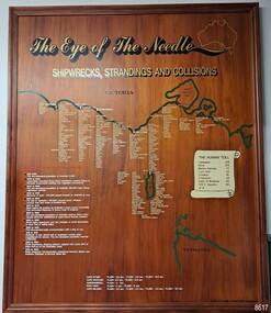
Artwork, other - Shipwreck Board, The Eye of the Needle: Shipwrecks, Stranding's and Collisions, ca 2002
... The interactive display highlights the shipwrecks, standings and collisions suffered by many vessels as they navigated the 'Eye of the Needle', a narrow stretch of Bass Strait. ...The interactive display highlights the shipwrecks, standings and collisions suffered by many vessels as they navigated the 'Eye of the Needle', a narrow stretch of Bass Strait. ...The Shipwreck Board is a feature of Flagstaff Hill Maritime Museum and Village/ its subject is explained briefly in the Museum's handbook, The Flagstaff Hill Navigator, published in 2008: - "Known as the ‘Eye of the Needle’ the treacherous entrance to Bass Strait is littered with the wreckage of large international vessels and smaller sail and steam craft used in coastal trade. The vessels bringing emigrants and cargo to Australia found the western entrance to Bass Strait the most dangerous part of their voyage. They had to thread their way between the southern point of Victoria (Cape Otway) and the northern point of King Island, a stretch of water less than 90 km wide. Many smaller coastal vessels were lost at Portland, Port Fairy, Warrnambool and Apollo Bay which are not safe harbours in certain weather conditions. "The Shipwreck Board shows shipwrecks, strandings and collisions which occurred in this area up to the year 1940. Wrecks are identified by a yellow light and collisions/strandings by a green light. These lights also identify the decade the wreck occurred by lighting up when the relevant decade button is pushed. Interesting happenings of the decades are listed next to the buttons." The Shipwreck Board's demonstration of The Eye of the Needle is an interactive visual display that helps teach the perils and dangers faced by early settlers in Victoria. It tells of the vast number of lives lost. It lists the names of many infamous shipwrecks and significant events.The large stained and lacquered timber board is mounted in a timber, frame. It is painted with a small sketch of Australia, and an enlarged outline of the southern coast of Victoria, King Island and the North West coast of Tasmania. The interactive display highlights the shipwrecks, standings and collisions suffered by many vessels as they navigated the 'Eye of the Needle', a narrow stretch of Bass Strait. The locations of the Lighthouses are pinpointed. Lists of groups of ships are below the coastlines. A painted scroll shows eight major shipwrecks with the number of lives lost for each one. A table shows historical facts associated with the decades from pre-1830 to 1940. A system of coloured lights compares the decades with the vessels that suffered damage. The board was created by artist and signwriter, Alex O'Flynn Computer Signs.flagstaff hill, maritime museum, maritime village, shipwreck coast, eye of the needle, shipwreck locations, bass strait, basses strait, king island, north west tasmania, south coast of victoria, cape otway, victorian lighthouse, king island lighthouse, strandings, coastal tracers, emigrant ships, sea trade, 1930s-1940s, shipwreck board, the eye of the needle, collosions, alex o'flynn, alex o’flynn computer signs, shipwrecks of western victoria -
 Mission to Seafarers Victoria
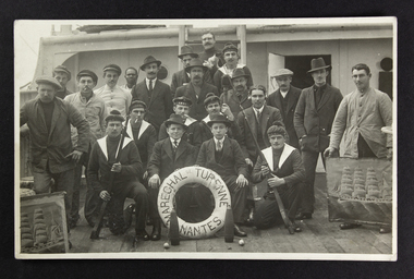
Postcard - Photograph, Black and white, Green Bros, 1918
... France-Empire, a chapter "Une traversée du trois-mâts nantais Maréchal de Turenne" (page 285 to 319) tells how the ship was navigating from London to New-York to load barrels of petrol bound for Melbourne....France-Empire, a chapter "Une traversée du trois-mâts nantais Maréchal de Turenne" (page 285 to 319) tells how the ship was navigating from London to New-York to load barrels of petrol bound for Melbourne. ...The Maréchal de Turenne, a three mast barque, was built in the "Chantiers de la Loire" shipyard in Nantes, port in the West of France, in 1899 by the company René Guillon et René Fleury. Capacity of 3000 barrels. The barque is called a "cap-hornier" in French. In a book written in 1973 by Georges Aubin, "La mer douce et cruelle", ed. France-Empire, a chapter "Une traversée du trois-mâts nantais Maréchal de Turenne" (page 285 to 319) tells how the ship was navigating from London to New-York to load barrels of petrol bound for Melbourne.The photograph demonstrates how prepared the merchant navy was during the First World War. The French Merchant Navy had additional men from the Navy: the six sailors in uniform and sailor "bachi" bonnet with the AMBC inscription were on the ship to support the crew in case of enemy attack. Two of those soldiers carry a bayonet. One of the sailors is wearing headphones: World War One saw telecommunication progress. At sea, the threat were the German submarines: the U-boats.The photograph depicting the 22 members of the crew was taken in October 1918 onboard the Marechal de Turenne. The two on the right and left side are holding a picture of the barque. One man at the back is holding a cat. 11 names are written at the back. The photograph was turned into a postcard.Printed at the back: On the left: Green Bros/Photo/251 Nelson Place, Williamstown Centered: Post Card/Correspondence/Address only Top right corner for the stamp: Kodak Australia Written at the back: octobre 1918 Souvenir du navire Maréchal de Turenne Berthot Jacquet Renaut R. Renaut H. Lecoq Mercier Berger Dubas Lorie Coat Tilloncrew, barque, french, 1918, marechal de turenne, nantes, wwi, world war one, first world war, great war, buoy, ship mascot, cat, a.m.b.c, bayonet, african, black man, apprentices, armement militaire des bâtiments de commerce, bachi, sailor beret, radio transmitters, telegraph, morse, telecommunication, german submarines, u-boats, cigarettes, smoking, williamstown, mission to seafarers, seamen's mission, nelson place, crews and ships -
 Merri-bek City Council
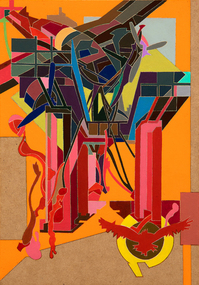
Oil on MDF, Raafat Ishak, Cairo, 2020-21
... His work delves into the exploration of identity and the challenges of navigating life between two cultures, particularly influenced by his teenage emigration from Cairo, Egypt. ...His work delves into the exploration of identity and the challenges of navigating life between two cultures, particularly influenced by his teenage emigration from Cairo, Egypt. ...Raafat Ishak is a Melbourne-based artist working across painting, installation and site-specific drawing. His work delves into the exploration of identity and the challenges of navigating life between two cultures, particularly influenced by his teenage emigration from Cairo, Egypt. Ishak employs a graphic visual language in his art, drawing inspiration from both architecture and his Arabic heritage. His artistic practice is situated at the crossroads of the personal and the political, delving into themes of utopia through the use of romanticised imagery. Through his work, Ishak seeks to scrutinize and interpret the complexities of cross-cultural dialogue. -
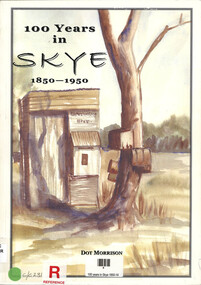 Narre Warren and District Family History Group
Book, Dot Morrison, 100 years in Skye 1850-1950, 2004
... The book also highlights the resilience and adaptability of the people of Skye as they navigated changes in technology, economy, and society. ...The book also highlights the resilience and adaptability of the people of Skye as they navigated changes in technology, economy, and society. ...The book 100 Years in Skye, 1850-1950 by Dot Morrison explores the history of Skye in a detailed account of the area's development over a century, including its social, economic, and cultural changes. The book's illustrations, maps, and photographs offer a vivid portrayal of life in Skye during this period. Includes an index and bibliography.99 p.; 29 cmnon-fictionThe book 100 Years in Skye, 1850-1950 by Dot Morrison explores the history of Skye in a detailed account of the area's development over a century, including its social, economic, and cultural changes. The book's illustrations, maps, and photographs offer a vivid portrayal of life in Skye during this period. Includes an index and bibliography.skye (vic.), skye (vic.) -- history, skye (vic.) -- road names, wedge family, skye (vic.) -- murders, south lyndhurst state school -
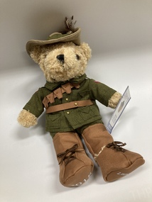
 Melbourne Legacy
Leisure object - Toy Bear, Legacy Bear $20 - Lighthorse bear, 2022
... They were experts at rough-riding from their lives in the bush and could navigate terrain easily for long periods with little food or water. ...They were experts at rough-riding from their lives in the bush and could navigate terrain easily for long periods with little food or water. ...In the 2000s Legacy released a range of Legacy Bears to expand the merchandise available for sale during Legacy Week and at other fundraising opportunities during the year. This Classic Lighthorse bear is different to the previous special edition Lighthorse bear and was a limited edition in 2020/22. The Light Horse Brigades were mounted infantry made up of mostly young men from the country. They were experts at rough-riding from their lives in the bush and could navigate terrain easily for long periods with little food or water. Sometimes special editions of the bears were produced. In 2021 the price was increased to $20 per bear.An example of the type of products sold along with Legacy Badges for fundraising in the 2010-2020s.Legacy bear dressed in a Lighthorse uniform with a printed cardboard tag.Printed tag gives the price as $20.legacy appeal, fundraising, legacy bear -
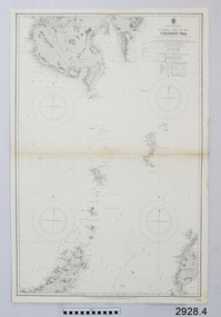 Flagstaff Hill Maritime Museum and Village
Document - Navigation Chart, Eastern Part of the Celebes Sea, Ca. 1928
... ...navigate...The set of charts and their chart are of significance as examples of equipment and documents used to navigate the oceans of the world, particularly to Australia. ...This is an Official British Admiralty Navigation Chart, one of a set of 65 charts donated together with a wooden chart case. It was published and printed in London in 1928 by the British Admiralty. Navigation charts are drawn by professional hydrographers and describe the geography of land and water, enabling a water based navigator on board vessels such as ships to safely negotiate between ports locally and around the world. They are drawn to a particular standard with common symbols noting landmarks. The charts are used in conjunction with other navigational instruments and tools to calculate the vessel’s exact location and a safe route to its destination.The set of charts and their chart are of significance as examples of equipment and documents used to navigate the oceans of the world, particularly to Australia. Migration to Australia is an important part of this country's history.British Admiralty Navigation Chart - Eastern Part of the Celebes Sea - printed on rectangular white paper. Published in London by the British Admiralty in 1928.warrnambool, shipwreck coast, flagstaff hill, flagstaff hill maritime museum, flagstaff hill maritime village, chart, map, navigate, navigation, location, vessel, 1928, british admiralty, hydrographer, geography, admiralty chart, celebes sea -
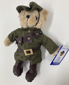
 Melbourne Legacy
Leisure object - Toy Bear, Legacy Bear $15 - Lighthorse Bear, 2018
... They were experts at rough-riding from their lives in the bush and could navigate terrain easily for long periods with little food or water. ...They were experts at rough-riding from their lives in the bush and could navigate terrain easily for long periods with little food or water. ...In the 2000s Legacy released a range of Legacy Bears to expand the merchandise available for sale during Legacy Week and at other fundraising opportunities during the year. A special edition bear to commemorate 100 years from the end of World War One. The bear is wearing a World War One soldiers' uniform including a slouch hat with feather. The date 2018 and Legacy is printed on his boots. In 2020 another Lighthorse bear was released, retailing at $20, with slight differences to this one. The Light Horse Brigades were mounted infantry made up of mostly young men from the country. They were experts at rough-riding from their lives in the bush and could navigate terrain easily for long periods with little food or water. An example of the type of products sold along with Legacy Badges for fundraising in the 2010-2020s.Legacy bear dressed in World War One Soldier uniform with a printed cardboard tag.Printed tag gives the price as $15.legacy appeal, fundraising, legacy bear -
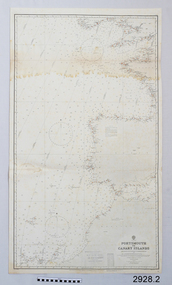 Flagstaff Hill Maritime Museum and Village
Document - Navigation Chart, Portsmouth to Canary Islands, CA. 1928
... ...navigate...The set of charts and their chart are of significance as examples of equipment and documents used to navigate the oceans of the world, particularly to Australia. ...Navigation charts are drawn by professional hydrographers and describe the geography of land and water, enabling a water based navigator on board vessels such as ships to safely negotiate between ports locally and around the world. They are drawn to a particular standard with common symbols noting landmarks. The charts are used in conjunction with other navigational instruments and tools to calculate the vessel’s exact location and a safe route to its destination.The set of charts and their chart are of significance as examples of equipment and documents used to navigate the oceans of the world, particularly to Australia. Migration to Australia is an important part of this country's history.British Admiralty Navigation Chart - Portsmouth to Canary Islands - printed on rectangular white paper. Published in London by the British Admiralty in 1928.warrnambool, shipwreck coast, flagstaff hill, flagstaff hill maritime museum, flagstaff hill maritime village, chart, map, navigate, navigation, location, vessel, 1928, british admiralty, hydrographer, geography, admiralty chart, portsmouth, canary islands