Showing 911 items matching navigation%20chart
-
 Greensborough Historical Society
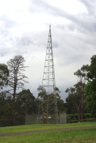
Photograph - Digital Image, Marilyn Smith, Air Navigation Facility, Montmorency, 2018. Tower, 04/12/2018
Air Navigation Facility, Palara Court Montmorency, is made up of a tower and brick building surrounded by wire fences. It is sited in parkland at the end of Palara Court close to the Plenty River Trail. Warning signs are placed on the fences, including: "This facility is provided for the control and guidance of aircraft". This photograph shows the tower on the site.Digital copy of colour photographsair navigation facility, air control, palara court montmorency -
 Bendigo Military Museum
Document - NAVIGATION DOCUMENT, Navigation Log, 22.11.1942
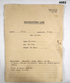
Navigation Log for flight by A.T.S in Aeroplane W - 2275 operating under order No 18/40. Details filled in on form RAAF A.84. Form filled in by F/L Smith, Sgt Jones, P/O Jones. Part of the Frederick Gardner DFC RAAF No 410533 collection. Refer Cat No 3536P for his service details.Four page Proforma printed in black ink, handwritten details in pencil on pages 1,2,3.The hand written information pages 1,2,3, details a flight from Pt Nepean to Woodside, weather, wind speed and observation points noted.training flight, raaf, w - 2275 -
 Bendigo Military Museum
Document - NAVIGATION DOCUMENT, Navigation Log, 6.2.1942
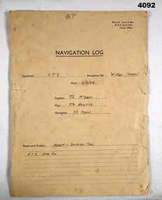
Navigation Log for Training Flights by A.T.S in Aeroplane W1234 (Anson), details filled in on RAAF form A.84. Filled by F/L McBoast, P/O Prune, F/O Knutts. (These are fictitious names to obviously give an example) Part of the Frederick Gardner Davey DFC No 410533 RAAF Collection. refer Cat No 3536P for his service details.Four page proforma printed in black ink, handwritten details on pages 1,2,3,, page four no handwritten details.Hand written in format on pages 1 - 3 in pencil detailing flight flight from Koroit to Smithton (Tasmania), weather, wind speed and observation points.navigation log, training flights, raaf -
 Shepparton RSL Sub Branch
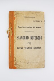
Book, Royal Australian Air Force, Standard Notebook for Initial Training Schools: Air Navigation, August 1942
This notebook contains information on air navigation and electrical science. It was issued to Roy Eliason (449852), a Shepparton local who enlisted in 1944 and served as a Leading Aircraftman with the 2nd Operational Training Unit Mildura. Contents include: Appendix I: Law, Discipline, Administration and Organisation, Hygiene and Sanitation, Notes on Meteorology, Definitions, The principles of flight, Airframes, Engine; Appendix II: Mathematics problems for revision.This notebook has significant research potential, as it bears the service number of the owner: Roy Eliason. Roy Eliason's service history is well documented in the National Archives of Australia and this book provides an insight into a period of his service. Notebooks such as this were presumably issued to new recruits in the early stages of their service. Though this copy is in fair condition with several signs of wear, these signs may in fact increase the significance of the item, demonstrating the frequent use of this item in the hands of a new recruit to the Royal Australian Air Force. Series of pages bound via twine passed through four holes along left side. Front and back cover are card with orange vinyl/fabric strip and paper cover bearing title text. Orange pages throughout mark sections. Book printed throughout.Inscribed on front cover: "449852/AC2 ELIASON R/B/2". Inscribed on interior "449852/ELIASON. R./B/2". air navigation, training, royal australian air force, raaf, eliason, world war ii, wwii, second world war -
 Moorabbin Air Museum
Manual (Item) - Private Pilot Navigation Volume 1 , Basic Navigation Theory , Radio Navigation Aids
-
 Flagstaff Hill Maritime Museum and Village
Book
Joachim Popp Hamburg Trigonometric navigational calculations at an advance level. In German.Navigation School Bookflagstaff hill, warrnambool, shipwrecked-coast, flagstaff-hill, flagstaff-hill-maritime-museum, maritime-museum, shipwreck-coast, flagstaff-hill-maritime-village, navigation, navigation school book, book -
 Bendigo Military Museum
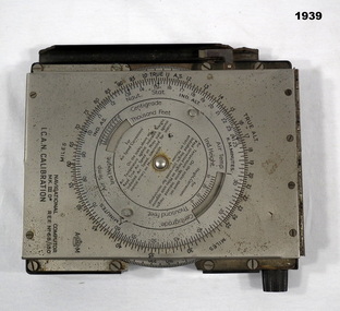
Equipment - COMPUTER, c.1939
Item used by Navigators or Pilots of small aircraft. Belonged to Maxwell Lennox MATHESON 418447 RAAF. Refer Cat No1959 for his service history.NAVIGATIONAL Computer Mark III.D, metal - bakelite, construction rectangular box shape, top lid hinges open. Top lid has a circular adjustment. Inside has another circular adjustment. Centre is a graph in red which winds by a dial on side. Inside top lid hand written in black are items of Navigation."NAVIGATIONAL Computer MKIID REF No 68/180 ICAN CALIBRATION"electrical technology, appliances & accessories, navigational -
 Warrnambool and District Historical Society Inc.
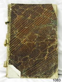
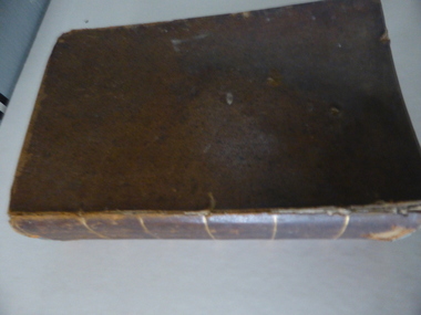
Book, A Complete Epitome of Practical Navigation - J W Norie, 1848
This book is a 19th Century treatise on aids to navigation. It belonged to John Cowtan who held land near the Cassady's Bridge area in Caramut Road today (he was related to the Cassady family) and who is mainly important in the history of Port Fairy. Captain John Cowtan was a ship's master for John Griffiths and a Launceston entrepreneur and ship owner between 1839 and 1844. In 1847 he went into partnership with John Bland, establishing a merchant's business with riverside buildings at the Port Fairy wharf. He left Port Fairy in the 1860s. The date of John Cowtan's signature in this book is 1849 (certainly a very early one in our history) and inside the front cover he has written notes about the local weather, mainly as it affected sailing conditions in late 1849 and early 1850. These notes are of great historical interestThis book is of great interest because it belonged to a Port Fairy historical figure and because of the hand written weather notes inside the front cover. This is a hard covered,leather bound book of 680 pages. It contains printed text, illustrations, tables, maps and sketches.One page is torn Some pages are stained. . J Cowtan 1849john cowtan, port fairy -
 Dandenong/Cranbourne RSL Sub Branch
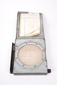
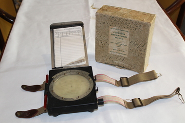
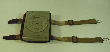
Equipment - Dalton Air Navigation Computer, Unknown
Grey metal boxed navigational computer, hinged lid with notebook attachedUnder metal lid inscribed 'Navigational Computer MK. 111 D. REF. 6B/180'16 On note pad Dalton 'Air Navigation Computer, as used by Flt Lt F.P. Field Aus 4o1817 1941,46. On operations over Atlantic Ocean on 'short' Sunderland 4 engine flying boats. -
Moorabbin Air Museum
Manual (Item) - Private Pilot Licence - Navigation Volume 2 ,Flight Planning , En Route Navigation
-
Moorabbin Air Museum
Manual (Item) - Royal Air Force -- Manual - Air Navigation - Vol.1 Theory & Practice of Air Navigation
Royal Air Force -
Moorabbin Air Museum
Manual (item) - Air Navigation vol 5 Radio Navigation Aids - RAF Air Ministry Oct 1947
-
Moorabbin Air Museum
Manual (item) - Air Navigation vol 5 Radio Navigation Aids - RAF Air Ministry Oct 1947
-
Moorabbin Air Museum
Manual (Item) - Air Navigation - a introduction to Practical Navigation
-
 Dandenong/Cranbourne RSL Sub Branch
Equipment - RAAF Navigational Computer, White and Gillespie (Melb.) Pty Ltd, Possibly 1940
WWII Historical significanceRAAF Navigational computer MK111 D used in WW11 in aircraft for plotting direction and wind speed with original box.Identification number G6B/145. Serial No WG/2677*. Contains original pencil from 1940 and navigational notebook. -
 B-24 Liberator Memorial Restoration Australia Inc
Computer Navigational MkIII D, White & Gillespie (Melb) Pty Ltd, c. 1940
RAAF Manual navigation aircraft calculator(early computer)General issue to allied pilots and navigators for airspeed,altitude,air temperature and drift calculations.Black metal box with SS flap-top cover, moulding and straps for knee attachment.Engraving No. 19, Ident.No. G6B/145. I.C.A.N. Serial No. WG/1716*. Computer Navigational Mk.IIID -
 Port Fairy Historical Society Museum and Archives
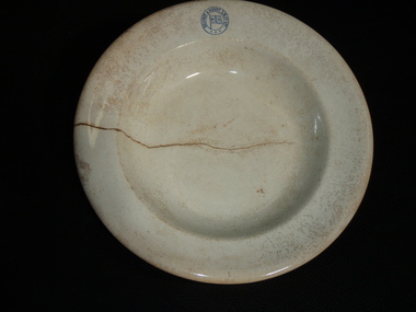
Domestic object - Soup bowl
Part of the crockery used on the "S.S.Casino" one of the Belfast and Koroit Steam Navigation Company ships used on the Melbourne-Port Fairy -Portland run. Sank in 1937 in Apollo Bay.Bowl: large white soup bowl with the inscription of the Belfast & Koroit Steam navigation Company"Belfast & Koroit S N Co Ltdlocal history, domestic items, crockery, belfast and koroit steam navigation company, s.s.casino -
 Seaworks Maritime Museum
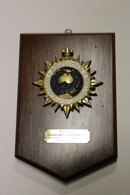
Plaque, Another Hamilton Design
One varnished teak board plaque from the Australian Institute of Navigation with a metal enamelled emblem of AustraliaPresented to Howard Smith Industries P/L in appreciation of your continuing support December 1995 Australian Institute of Navigation Another Hamilton Design the corporate award specialist ph: 026744266 fax: 026744758 -
Phillip Island and District Historical Society Inc.
Book, United States. Naval Oceanographic Office, Sight reduction tables for marine navigation. Vol.3., Latitudes 30-?45 ?inclusive, 1971
Text on lining papers. - Transparent sheet (1 ill.) as insert.navigation, tables -
Phillip Island and District Historical Society Inc.
Book, JEANS, H.W, Navigation and nautical astronomy, the practical part, containing rules for finding the latitude and longitude, and the variation of the compass, with numerous examples, 1853
Inscribed 'Jno. Cleeland, Melbourne'. Labelled 'Phillip Island Historical Society, Cleeland Bequest'. Pencilled drawing inside back cover, 'hope' & 'anchor'. -
 Moorabbin Air Museum
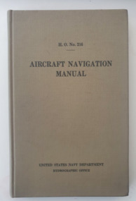
Manual (Item) - H.O.No.216 Aircraft Navigation Manual; United States Navy Department Hydrographic Office, Aircraft Navigation Manual United States Navy
Produced by the United States Navy during 1940. While the Second World War had broken out, the United States where yet to joinworld war two, united states navy, aircraft navigation -
Moorabbin Air Museum
Manual (Item) - RAF Navigation Instrument Repair Manual, Navigation Instruments: Repair and Reconditioning Instructions
Air Publication 1275B, Volume 6. On front cover: "Note.- on all leaves issued with A.L.s I to 19, for "Vol 2 Part 3" read "Vol. 6". Any referenes to "A.P. 1275B., Vol. 2, Part 3" are also to be read as "A.P. 1275B, Vol. 6" -
Moorabbin Air Museum
Manual (Item) - US Navy Air Navigation Training Course Part 3, Dead Reckoning, Air Navigation - Part Three: Dead Reckoning and Lines of Position
-
Moorabbin Air Museum
Manual (Item) - Narco Avionics Navigation Converters Maintenance Manual, VOA-40 and VOA-50 Series Navigation Converters: 14/28 Volt Maintenance Manual
-
Moorabbin Air Museum
Manual (Item) - Proposal for the Introduction of a New Generation of VHF Navigation Receiver, Draft No. 1 Of Project Paper No. 567 Mark 3 Airborne VHF Navigation Receiver
-
Moorabbin Air Museum
Book (Item) - Examples & Exercises In Elementary Air Navigation
By M.J.Hearley , B.Sc For Use Of Air Crews Of The RAF Army Co-Operation Fleet Arm, Cadets In The Air Training Corps -
Moorabbin Air Museum
Book (Item) - Air Navigation Simply Explained
By W.Myerscough -
Moorabbin Air Museum
Manual (Item) - RAAF - Fitment Of Wild RC-10 Cartographic Survey Camera And NF2 Navigation Sight, Fitment Of Wild RC-10 Cartographic Survey Camera And NF2 Navigation Sight
AAP 7214.006-769 (-100) -
Moorabbin Air Museum
Manual (Item) - RAAF - TACAN Navigation System Type AF/GRN-804 Maintenance Manual Navigation Set TACAN An/URN-25, TACAN Navigation System
AAP 7802.015-2M-1 -
Moorabbin Air Museum
Manual (Item) - RAAF - Navigation Instruments Miscellaneous And Tables, Navigation Instruments Miscellaneous And Tables
Air Publication 1275B Volume 1 Section 17