
Showing 105 items matching "navigation equipment"
-
 Moorabbin Air Museum
Manual (Item) - Cessna - 300 Series Avionic Communications And Navigation Equipment , Owner's Manual
... Cessna - 300 Series Avionic Communications And Navigation Equipment , Owner's Manual...Cessna - 300 Series Avionic Communications And Navigation Equipment , Owner's Manual...Cessna - 300 Series Avionic Communications And Navigation Equipment , Owner's Manual Manual Cessna - 300 Series Avionic Communications And Navigation Equipment , Owner's Manual ... -
Moorabbin Air Museum
Manual (Item) - RAAF - Doppler Navigation Equipment (Green Satin)
... RAAF - Doppler Navigation Equipment (Green Satin)...RAAF - Doppler Navigation Equipment (Green Satin)...AAP 7842.007-2 RAAF - Doppler Navigation Equipment (Green Satin) Manual RAAF - Doppler Navigation Equipment (Green Satin) ...AAP 7842.007-2 -
Moorabbin Air Museum
Manual (Item) - Doppler Navigation Equipment (Green Satin) , Comprising Transmitter-Receiver Type 3710, Indicator Electrical Type 101 , TRacking Unit Type 100, Aerial System 501 Bay Servicing Schedule, Doppler Navigation Equipment (Green Satin) Bay Servicing Schedule
... Doppler Navigation Equipment (Green Satin) , Comprising Transmitter-Receiver Type 3710, Indicator Electrical Type 101 , TRacking Unit Type 100, Aerial System 501 Bay Servicing Schedule...Doppler Navigation Equipment (Green Satin) Bay Servicing Schedule...AAP 7842.007-6-10 Doppler Navigation Equipment (Green Satin) Bay Servicing Schedule Manual Doppler Navigation Equipment (Green Satin) , Comprising Transmitter-Receiver Type 3710, Indicator Electrical Type 101 , TRacking Unit Type 100, Aerial System 501 Bay Servicing Schedule ...AAP 7842.007-6-10 -
Queenscliffe Maritime Museum
Equipment - Navigation Equipment
... Navigation Equipment...Includes Sat Nav System Model RS5000 Raven Sorenson Equipment Navigation Equipment ...Benmar Model 16B Auto Pilot System. Includes Sat Nav System Model RS5000 Raven Sorensonbenmar, autopilot, satnav, model 16b, model rs5000 -
 Queenscliffe Maritime Museum
Equipment - Recognition Plaque
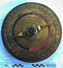
... Circular brass plaque inscribed with J5 North Sea 1917 1918 made from a piece of navigational equipment used on the submarine J5 mounted on wood...Popular diving sites in Ships Graveyard outside the rip between Point Lonsdale and Barwon Heads J Class Submarines J5 Ships graveyard Port Phillip Submarine J5 North Sea 1917 - 1918 Circular brass plaque inscribed with J5 North Sea 1917 1918 made from a piece of navigational equipment used on the submarine J5 mounted on wood Equipment Recognition Plaque ...In the early 1920s Australia was gifted six J class submarines from the Royal Navy. These were the latest and largest submarines built by the RN for service in World War I. They were competent but were in service with the Royal Navy for only a short time before the end of the war. Once in Australia they were placed into service but there was little appetite for submarines or in fact any other military endeavour in the early ‘twenties’. The world was exhausted from a long and dirty war followed by a devastating Influenza Epidemic. The J class boats were soon retired and sunk as breakwaters or scuttled in the ship graveyard area off the mouth of Port Phillip Bay.Popular diving sites in Ships Graveyard outside the rip between Point Lonsdale and Barwon HeadsCircular brass plaque inscribed with J5 North Sea 1917 1918 made from a piece of navigational equipment used on the submarine J5 mounted on woodSubmarine J5 North Sea 1917 - 1918j class submarines, j5, ships graveyard, port phillip -
 Flagstaff Hill Maritime Museum and Village
Instrument - Ship Log, 1880-1890
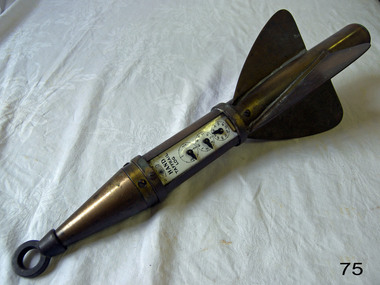
... navigation...navigational equipment...The Hand Company built navigational equipment for all varieties of floating vessels, and operated a chain of retail outlets with “service stations” in numerous port cities, including Baltimore and New Orleans, until 1956. ...The Hand Company built navigational equipment for all varieties of floating vessels, and operated a chain of retail outlets with “service stations” in numerous port cities, including Baltimore and New Orleans, until 1956. ...The John E. Hand & Sons Company was founded in Philadelphia in 1873, quickly gaining a reputation as competent manufacturers of nautical instruments and compass adjusters. In fact, John Enos Hand, the company founder, is recognised as the first man in America to adjust a compass aboard an iron ship. The Hand Company built navigational equipment for all varieties of floating vessels, and operated a chain of retail outlets with “service stations” in numerous port cities, including Baltimore and New Orleans, until 1956. Service stations sold Hand instruments as well as other nautical paraphernalia and provided compass adjusting services. Additionally, John E Hand and his two sons, John L Hand and Bartram Hand, were inventors in their own right who patented design improvements for numerous instruments that were employed in the company’s work. Commercial and private contracts dominated the firm’s business until the late 1930s when the United States military began preparations for World War II. Although the Hand Company never completely abandoned its involvement with private industry, after World War II, military contracts monopolised their business. The Company obtained contracts with the Navy, Coast Guard and Marines to develop new instruments, and to build military-engineered nautical equipment. Of note are the wrist compass, developed for the Navy beginning in the 1950s, and the Mark VII Model 5 Navy Standard Binnacle. Although it moved numerous times, the Hand Company headquarters and factory remained in the Delaware Valley, occupying several buildings in Philadelphia and southern New Jersey. Maintaining its central office in Philadelphia well into the 1900s, the factory was moved to Atco, New Jersey around the turn of the twentieth century and subsequently to Haddon field, New Jersey. It moved one last time in the 1960s to Cherry Hill, New Jersey. In 1997, California-based Sunset Cliffs Merchandising Corporation purchased the Hand Company and all its assets for $100,000. "HAND" brand taffrail log by John F. Hand and Sons Co. Register is enclosed in log, has a glass front and 3 dials on an enameled surface, the first dial registers the miles up to 100, the second registers the units up to 10 mile, the third registers quarters of a mile. The item is rocket shaped with a three blade rotor and a rope ring attachment at one end; the rotor will spin when a rope is attached, allowing the apparatus dials to measure the ship's speed when it is dragged behind a ship. Diagram of the 'Hand' trademark with a compass card in the middle, inscription reads "John F Hand and Sons Co" and "PHILA-BALTO" ( Abbreviation for: Philadelphia / Baltimore) flagstaff hill, warrnambool, shipwrecked coast, flagstaff hill maritime museum, maritime museum, shipwreck coast, flagstaff hill maritime village, great ocean road, bartram hand, john enos hand, john f. hand and sons co, john l hand, john hand & sons instrument makers, john hand & sons of philadelphia, marine instrument, marine service station, mechanical ship log, nautical instrument, nautical navigation, navigational equipment, scientific instrument, ship log, ship log register, ship’s speed, sunset cliffs merchandising corporation, speed log, rocket log, harpoon log, taffrail log, taff rail log -
 Flagstaff Hill Maritime Museum and Village
Equipment - Distant Signal, 1897-1931
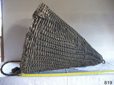
... ...navigation equipment...The same shapes continue to be used today for the sets of Day Shapes used as marine navigational signals that are mandatory on certain-sized vessels. flagstaff hill warrnambool flagstaff Hill Maritime Museum and village Shipwreck Coast Marine Navigation Marine communications Communication Signal Lifesaving ship at sea day shape masthead signal day signal day mark signals marine technology safety equipment navigation equipment marine day shape day marker cane day shape signal cone day signal cone cone signal cone day shape distant signal flagstaff signal signal station communications signals marine signals flaghoists International Marine Conference International Code of Signals signal codes marine safety signal flags daymark day symbol navigation Warrnambool flagstaff 1854 1857 1931 1887 1897 Distant Signal Cone, part of a Flagstaff signal set. ...This three-dimensional Distant Signal is part of a Flagstaff Signal set of ball, cone and drum shapes. It has been woven and then fabricated with strong metal swivel fittings and loops for suspending from a high point on a flagstaff at a signal station or on a ship’s masthead. The cane signal was constructed to withstand all weather and to be visible from a long distance. The gaps between the woven cane allow air to pass through, minimising possible swaying. Similar sets were made from rope or fabric. Warrnambool's Flagstaff was erected in 1854. Its primary use was to display visual signals that could convey messages between land and sea. It was also used to notify the local population of the approach of ships. One of the popular signalling codes in use in the early-to-mid 1800s was the Marryat’s Code but there were others in use as well; there was no one standard code. In 1857 the International Marine Conference adopted an International Code of Signals as a standard communications system for all vessels that could be understood in many different languages. The Normanby Advertiser reported on June 5th 1857 a query from the Post Master General as to whether the request of the Chief Harbour Master would be carried out, in that Warrnambool would receive a new flagstaff and a set of Marryatt’s signal flags. The Table of Codes was published, showing how to use combinations of these flags to send messages. The Code was revised in 1887 to cover situations where distance, light, wind and weather conditions affected the visibility of the flags and prevented clear communication. The first report of the International Code of Signals Committee of 1897 warned signalmen not to rely on ordinary semaphore flags and introduced a Distant Signal Code using either particular semaphore flags or the three-dimensional shapes of a ball, cone and drum that aligned with the semaphore flag shapes of a circle, pennant and square. International Code of Signals In 1931, after World War I’s experiences in using signal codes, the International Code of Signals conference in Washington revised and published the rules for the conduct of signalling. One of the changes was that “the use of the Distant Signals and of fixed semaphore was abandoned”. It is of interest to know that modern marine law in many countries insists that a set of Day Shapes must be carried onboard vessels of a certain size. These highly visible geometric shapes are used at sea in daylight to communicate messages between vessels. They are used in a similar way to the Distant Signals, in that different combinations of shapes represent different messages. The set of shapes includes a ball, cylinder, cone and diamond. The shapes are hung between the top of the vessel’s foremast and the front of the vessel. They are only coloured black and are about 1.5 metres high. The vertical line of shapes can mean messages such as Boat not under command, Fishing, and Under sail and power.Distant Signals were an important means of marine communication from the late 1880s to the early 1930s, including during World War I. They were an advancement to the International Shipping Codes and safety. The cane signals’ shapes appear to be the same from whatever direction they are viewed, removing confusion about the message they convey. The same shapes continue to be used today for the sets of Day Shapes used as marine navigational signals that are mandatory on certain-sized vessels.Distant Signal Cone, part of a Flagstaff signal set. A woven cane cone, painted black, with a metal rod passing through the centre and two crossed metal bars at the base. The central rod has a loop at the top and passes through the bars at the base, finishing in a metal loop. The rod has swivels at each end.flagstaff hill, warrnambool, flagstaff hill maritime museum and village, shipwreck coast, marine navigation, marine communications, communication signal, lifesaving, ship at sea, day shape, masthead signal, day signal, day mark signals, marine technology, safety equipment, navigation equipment, marine day shape, day marker, cane day shape, signal cone, day signal cone, cone signal, cone day shape, distant signal, flagstaff signal, signal station, communications, signals, marine signals, flaghoists, international marine conference, international code of signals, signal codes, marine safety, signal flags, daymark, day symbol, navigation, warrnambool flagstaff, 1854, 1857 1931, 1887, 1897 -
 Flagstaff Hill Maritime Museum and Village
Equipment - Distant Signal, 1897-1931
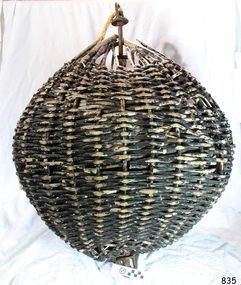
... ...navigation equipment...The same shapes continue to be used today for the sets of Day Shapes used as marine navigational signals that are mandatory on certain-sized vessels. flagstaff hill warrnambool flagstaff Hill Maritime Museum and village Shipwreck Coast Marine Navigation Marine communications Communication Signal Lifesaving ship at sea day shape masthead signal day signal day mark signals marine technology safety equipment navigation equipment marine day shape day marker cane day shape signal ball day signal ball Ball signal ball day shape distant signal flagstaff signal signal station communications signals marine signals flaghoists International Marine Conference International Code of Signals signal codes marine safety signal flags daymark day symbol navigation Warrnambool flagstaff 1854 1857 1931 1887 1897 Distant Signal Ball, part of a Flagstaff signal set. ...This three-dimensional Distant Signal is part of a Flagstaff Signal set of ball, cone and drum shapes. It has been woven and then fabricated with strong metal swivel fittings and loops for suspending from a high point on a flagstaff at a signal station or on a ship’s masthead. The cane signal was constructed to withstand all weather and to be visible from a long distance. The gaps between the woven cane allow air to pass through, minimising possible swaying. Similar sets were made from rope or fabric. Warrnambool's Flagstaff was erected in 1854. Its primary use was to display visual signals that could convey messages between land and sea. It was also used to notify the local population of the approach of ships. One of the popular signalling codes in use in the early-to-mid 1800s was the Marryat’s Code but there were others in use as well; there was no one standard code. In 1857 the International Marine Conference adopted an International Code of Signals as a standard communications system for all vessels that could be understood in many different languages. The Normanby Advertiser reported on June 5th 1857 a query from the Post Master General as to whether the request of the Chief Harbour Master would be carried out, in that Warrnambool would receive a new flagstaff and a set of Marryatt’s signal flags. The Table of Codes was published, showing how to use combinations of these flags to send messages. The Code was revised in 1887 to cover situations where distance, light, wind and weather conditions affected the visibility of the flags and prevented clear communication. The first report of the International Code of Signals Committee of 1897 warned signalmen not to rely on ordinary semaphore flags and introduced a Distant Signal Code using either particular semaphore flags or the three-dimensional shapes of a ball, cone and drum that aligned with the semaphore flag shapes of a circle, pennant and square. International Code of Signals In 1931, after World War I’s experiences in using signal codes, the International Code of Signals conference in Washington revised and published the rules for the conduct of signalling. One of the changes was that “the use of the Distant Signals and of fixed semaphore was abandoned”. It is of interest to know that modern marine law in many countries insists that a set of Day Shapes must be carried onboard vessels of a certain size. These highly visible geometric shapes are used at sea in daylight to communicate messages between vessels. They are used in a similar way to the Distant Signals, in that different combinations of shapes represent different messages. The set of shapes includes a ball, cylinder, cone and diamond. The shapes are hung between the top of the vessel’s foremast and the front of the vessel. They are only coloured black and are about 1.5 metres high. The vertical line of shapes can mean messages such as Boat not under command, Fishing, and Under sail and power.Distant Signals were an important means of marine communication from the late 1880s to the early 1930s, including during World War I. They were an advancement to the International Shipping Codes and safety. The cane signals’ shapes appear to be the same from whatever direction they are viewed, removing confusion about the message they convey. The same shapes continue to be used today for the sets of Day Shapes used as marine navigational signals that are mandatory on certain-sized vessels.Distant Signal Ball, part of a Flagstaff signal set. A round woven cane ball, painted black, with a metal rod passing through the centre. The rod has a loop at each end, then a concave, octagonal metal plate that rests on the outside surface of the ball, serving as a washer. The rod has swivels at each end.flagstaff hill, warrnambool, flagstaff hill maritime museum and village, shipwreck coast, marine navigation, marine communications, communication signal, lifesaving, ship at sea, day shape, masthead signal, day signal, day mark signals, marine technology, safety equipment, navigation equipment, marine day shape, day marker, cane day shape, signal ball, day signal ball, ball signal, ball day shape, distant signal, flagstaff signal, signal station, communications, signals, marine signals, flaghoists, international marine conference, international code of signals, signal codes, marine safety, signal flags, daymark, day symbol, navigation, warrnambool flagstaff, 1854, 1857 1931, 1887, 1897 -
 Flagstaff Hill Maritime Museum and Village
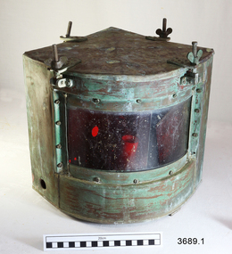
Functional object - Navigation Side Lamp, early 20th century
... ...navigation equipment...These lamps are an historical example of navigational equipment used in the early 20th century, adhering to a navigational standard that is worldwide, and a design similar to what is still being used today. ...This pair of navigational lamps or lights was fitted to the vessel S.S. Rowitta when it was renovated to become a display passenger ferry at Flagstaff Hill Maritime Village from 1976-2015. Navigation lamps are used to indicate a vessel’s position and direction of travel to other vessels nearby. This system of coloured lamps is standardised throughout the world for all marine vessels, red is for port and green for starboard, (red is for the boats right hand side). These navigation lamps were not the original fittings for this vessel but had come from a similar vessel of the same era of the early 1900’s. The history of the lamp fittings at this time is unknown. SS ROWITTA: - The 1909 steam ferry, SS Rowitta, was installed as an exhibit at Flagstaff Hill in 1975 and was enjoyed by many visitors for 40 years. Rowitta was a timber steam ferry built in Hobart in 1909 using planks of Huon and Karri wood. She was a favourite of sightseeing passengers along Tasmania’s Tamar and Derwent rivers for 30 years. Rowitta was also known as Tarkarri and Sorrento and had worked as a coastal trading vessel between Devonport and Melbourne, and Melbourne Queenscliff and Sorrento. In 1974 Rowitta was purchased by Flagstaff Hilt to convert into a representation of the Speculant, a historic and locally significant sailing ship listed on the Victorian Heritage Database. (The Speculant was built in Scotland in 1895 and traded timber between the United Kingdom and Russia. Warrnambool’s P J McGennan & Co. then bought the vessel to trade pine timber from New Zealand to Victorian ports and cargo to Melbourne. She was the largest ship registered with Warrnambool as her home port, playing a key role in the early 1900s in the Port of Warrnambool. In 1911, on her way to Melbourne, she was wrecked near Cape Otway. None of the nine crew lost their lives.) The promised funds for converting Rowitta into the Speculant were no longer available, so she was restored back to her original configuration. She represented the importance of coastal traders to transport, trade and communication in Australia times before rail and motor vehicles. Sadly, in 2015 the time had come to demolish the Rowitta due to her excessive deterioration and the high cost of on-going repairs. She had given over 100 years of service and pleasure to those who knew her. These lamps are an historical example of navigational equipment used in the early 20th century, adhering to a navigational standard that is worldwide, and a design similar to what is still being used today. They were used on the display vessel at Flagstaff Hill Maritime Village as an aid to maritime education. The Rowitta represents the importance of coastal traders to transport, trade and communication along the coast of Victoria, between states, and in Australia before rail and motor vehicles. The vessel was an example of a ferry built in the early 20th century that served many different roles over its lifetime of over 100 years. Two side navigation ship's lamps, quarter circle shaped metal boxes with glass window and removable lid. The lid attaches to the box using four brackets, wingnuts and screws that swing down out of the way. The window of double-thickness glass is inserted on the curved side of the box and attached by screws around the frame. The inner glass panel is coloured according to the lamp’s use; port is red and starboard green. The port lamp has a round hole cut into each of the two straight sides and an electrical fitting inside. The starboard lamp also has a hole in each straight side (one with a threaded fitting). Its lid has an additional cross bar on top that has a circular space in the centre, nuts and screws fit through holes in the ends and a folding handle is attached across the centre space. The lamps were once fitted onto the vessel Rowitta. The starboard lamp has an inscription stamped into the metal. Impressed on 3689.2; “STARBOARD PATT 8025” flagstaff hill, warrnambool, flagstaff hill maritime museum, maritime museum, flagstaff hill maritime village, navigation lamp, navigation light, navigation equipment, starboard patt 8025, ship’s fitting, rowitta, tarkarri, speculant, purdon & featherstone of hobart, passenger ferry 1909, vessel, display rowitta, display passenger ferry, sorrento -
 Flagstaff Hill Maritime Museum and Village
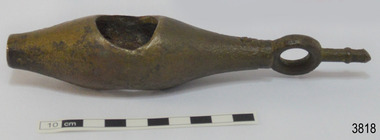
Instrument - Ship Log
... ...navigation equipment...The Grange is an example of a mid-19th century vessel that carried a weapon of defence onboard. flagstaff hill warrnambool flagstaff hill maritime museum maritime museum shipwreck coast flagstaff hill maritime village great ocean road west coast trader apollo bay mid-19th century shipwreck the grange scottish barque little henty reef captain a alexander underwater explorers club of victoria vhr 5297 coastal trader wooden shipwreck john chance wooden ship taffrail log marine instrument marine technology navigation nautical instrument mechanical log nautical navigation navigation equipment scientific instrument ship log ship log register ship speed taff rail log patent log towed log taffrail log fish edward massey thomas walker Ship log fitting, called a fish; part of a brass navigational instrument, likely to be from a taffrail log. ...The ship's log part, called a fish, is likely to be from a mechanical taffrail log system. It was recovered from the wreck site of the barque, the 1840-1852 Grange. There are no marks on the fish to identify its maker or model. It is part of the John Chance Collection. This ‘fish’ is part of an early to mid-1800s ship's log. It would likely have been part of a taffrail log connected to a rotor (also called propeller, spinner) by a strong line, and the other end connected by a line to a dial mounted on the taffrail, or stern rail, at the stern of the vessel. As the propeller rotated through the water it would spin the log, which in turn would cause a number to register on the dial, showing the current speed in knots; one knot equals one nautical mile per hour. TAFFRAIL LOGS A taffrail log is a nautical instrument used for measuring the speed of a vessel, providing vital navigational information to be calculated, such as location and direction. A log has been used to measure the speed of a vessel since the 1500s. A simple piece of wood was tied to a long line and thrown into sea at the back of the vessel. The rope was knotted all along at equal distances apart. On a given signal the log line was pulled back into the vessels, the knots counted until the log came up, then the figures were calculated by a navigator In 1802 the first successful mechanical log available for general use was invented by Edward Massey. It had a rotor 'V' section connected to a recording mechanism. The water’s movement rotated the rotor, which intern sent the movement to the recorder. There are examples of this invention available to see in some of the maritime museums. Thomas Walker, nephew of Edward Massey, improved on Massey’s design, and Walker and his son took out a patent on the A1 Harpoon Log. In 1861. Both Massey and Walker continued to improve the designs of the taffrail log. New designs were still being introduced, even up to the 1950s. THE GRANGE, 1840-1858- The wooden barque ’Grange’ was a three-masted ship built in Scotland in 1840 for international and coastal trade. On March 22, 1858, the Grange set sail from Melbourne under Captain A. Alexander, carrying a cargo of ballast. The barque had left the Heads of Phillip Bay and was heading west along the Victorian coast towards Cape Otway. The ship struck Little Haley’s Reef at Apollo Bay due to a navigational error and was stuck on the rocks. The crew left the ship carrying whatever they could onto the beach. Eventually, the remains of the hull, sails and fittings were salvaged before the wreck of the Grange broke up about a month later. About 110 years later, in 1968, the wreck of the Grange was found by divers from the Underwater Explorers Club of Victoria. They were amazed to find a unique, six to nine pound carronade (type of small cannon) and a cannonball on the site. There have been no other similar carronades recorded. In that same year the anchor of the Grange was recovered by diver John Chance and Mal Brown. The ship’s log is significant historically as an example of hardware used when building wooden ships in the early to mid-19th century. The ship’s log is historically significant as an example of the work and trade of blacksmith. The ship’s log also has significant as it was recovered by John Chance, a diver from the wreck of the Grange in the 1968. Items that come from several wrecks along Victoria's coast have since been donated to the Flagstaff Hill Maritime Village’s museum collection by his family, illustrating this item’s level of historical value. The ship’s log is historically significant for its association with the 1840s wooden barque, the Grange. The Grange is an historical example of a Scottish built vessel used for international and coastal trader of both cargo and passengers in the mid-19th century. The Grange is an example of an early ship, designed with a wooden hull. It is significant as a ship still available to divers along the south coast of Victoria, for research and education purposes. The Grange is an example of a mid-19th century vessel that carried a weapon of defence onboard. Ship log fitting, called a fish; part of a brass navigational instrument, likely to be from a taffrail log. The metal is a tan colour and has rough surface with a sheen, and discolouration in places. Its basic shape is a hollow cylinder with ends tapering to a smaller size. In the centre there are opposing openings cut out, showing a rough texture inside. One end on the cylinder is closed with a ring and shank installed, fixed by an embedded screw through the end of the cylinder. There are no inscriptions.flagstaff hill, warrnambool, flagstaff hill maritime museum, maritime museum, shipwreck coast, flagstaff hill maritime village, great ocean road, west coast trader, apollo bay, mid-19th century shipwreck, the grange, scottish barque, little henty reef, captain a alexander, underwater explorers club of victoria, vhr 5297, coastal trader, wooden shipwreck, john chance, wooden ship, taffrail log, marine instrument, marine technology, navigation, nautical instrument, mechanical log, nautical navigation, navigation equipment, scientific instrument, ship log, ship log register, ship speed, taff rail log, patent log, towed log, taffrail log fish, edward massey, thomas walker -
 Flagstaff Hill Maritime Museum and Village
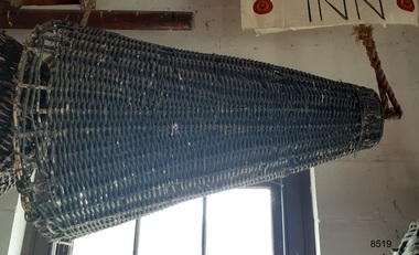
Equipment - Distant Signal, 1897-1931
... ...navigation equipment...The same shapes continue to be used today for the sets of Day Shapes used as marine navigational signals that are mandatory on certain-sized vessels. flagstaff hill warrnambool flagstaff Hill Maritime Museum and village Shipwreck Coast Marine Navigation Marine communications Communication Signal Lifesaving ship at sea day shape masthead signal day signal day mark signals marine technology safety equipment navigation equipment marine day shape day marker cane day shape signal cone day signal cone cone signal cone day shape distant signal flagstaff signal signal station communications signals marine signals flaghoists International Marine Conference International Code of Signals signal codes marine safety signal flags daymark day symbol navigation Warrnambool flagstaff 1854 1857 1931 1887 1897 Distant Signal Cone, part of a Flagstaff signal set. ...This three-dimensional Distant Signal is part of a Flagstaff Signal set of ball, cone and drum shapes. It has been woven and then fabricated with strong metal swivel fittings and loops for suspending from a high point on a flagstaff at a signal station or on a ship’s masthead. The cane signal was constructed to withstand all weather and to be visible from a long distance. The gaps between the woven cane allow air to pass through, minimising possible swaying. Similar sets were made from rope or fabric. Warrnambool's Flagstaff was erected in 1854. Its primary use was to display visual signals that could convey messages between land and sea. It was also used to notify the local population of the approach of ships. One of the popular signalling codes in use in the early-to-mid 1800s was the Marryat’s Code but there were others in use as well; there was no one standard code. In 1857 the International Marine Conference adopted an International Code of Signals as a standard communications system for all vessels that could be understood in many different languages. The Normanby Advertiser reported on June 5th 1857 a query from the Post Master General as to whether the request of the Chief Harbour Master would be carried out, in that Warrnambool would receive a new flagstaff and a set of Marryatt’s signal flags. The Table of Codes was published, showing how to use combinations of these flags to send messages. The Code was revised in 1887 to cover situations where distance, light, wind and weather conditions affected the visibility of the flags and prevented clear communication. The first report of the International Code of Signals Committee of 1897 warned signalmen not to rely on ordinary semaphore flags and introduced a Distant Signal Code using either particular semaphore flags or the three-dimensional shapes of a ball, cone and drum that aligned with the semaphore flag shapes of a circle, pennant and square. International Code of Signals In 1931, after World War I’s experiences in using signal codes, the International Code of Signals conference in Washington revised and published the rules for the conduct of signalling. One of the changes was that “the use of the Distant Signals and of fixed semaphore was abandoned”. It is of interest to know that modern marine law in many countries insists that a set of Day Shapes must be carried onboard vessels of a certain size. These highly visible geometric shapes are used at sea in daylight to communicate messages between vessels. They are used in a similar way to the Distant Signals, in that different combinations of shapes represent different messages. The set of shapes includes a ball, cylinder, cone and diamond. The shapes are hung between the top of the vessel’s foremast and the front of the vessel. They are only coloured black and are about 1.5 metres high. The vertical line of shapes can mean messages such as Boat not under command, Fishing, and Under sail and power.Distant Signals were an important means of marine communication from the late 1880s to the early 1930s, including during World War I. They were an advancement to the International Shipping Codes and safety. The cane signals’ shapes appear to be the same from whatever direction they are viewed, removing confusion about the message they convey. The same shapes continue to be used today for the sets of Day Shapes used as marine navigational signals that are mandatory on certain-sized vessels.Distant Signal Cone, part of a Flagstaff signal set. A woven cane cone, painted black, with a metal rod passing through the centre and two crossed metal bars at the base. The central rod has a loop at the top and passes through the bars at the base, finishing in a metal loop. The rod has swivels at each end.flagstaff hill, warrnambool, flagstaff hill maritime museum and village, shipwreck coast, marine navigation, marine communications, communication signal, lifesaving, ship at sea, day shape, masthead signal, day signal, day mark signals, marine technology, safety equipment, navigation equipment, marine day shape, day marker, cane day shape, signal cone, day signal cone, cone signal, cone day shape, distant signal, flagstaff signal, signal station, communications, signals, marine signals, flaghoists, international marine conference, international code of signals, signal codes, marine safety, signal flags, daymark, day symbol, navigation, warrnambool flagstaff, 1854, 1857 1931, 1887, 1897 -
 Flagstaff Hill Maritime Museum and Village
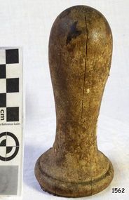
Equipment - Ship's Wheel, 1840
... ...navigation equipment...The “Success” is connected to the history of Australia because she was used as a merchant ship to transport immigrants to Australia, and was also used as a prison ship in Melbourne, a storage vessel, and as a floating “convict” museum, which travelled the world. flagstaff hill maritime museum maritime museum sailing ship success ship's wheel spoke Ship's steering wheel prison ship prison hulks convict ship spoke handle ship's wheel navigation equipment steering wheel "Success" Ship's wheel handle. ...This wooden spoke handle is from the wheel of the sailing ship “Success”, a former immigrant ship and later a convict hulk at Melbourne. The sailing ship “Success” was a teakwood vessel built in Natmoo (Natmaw), Tenasserim, Burma (now Myanmar) in 1840 for Cockerell & Co., Calcutta. Over its lifetime of 106 years, it was used to trade in the Indian subcontinent, to transport free emigrants to Australia, as a prison hulk in the Port of Melbourne for both hardened criminals, and later for women and boys, as a storage vessel for ammunition, a reformatory, and as a floating museum sent around the world to tell the tale of the convict era. During the time “Success” was used as a museum, pamphlets were distributed to paying customers advertising erroneously, that the “Success” was the oldest ship in the world. The “Success” sank and was re-floated twice: the first in Sydney in 1885, the second in the USA in 1918, before it was finally burned and sank on July 4, 1946 in Lake Erie, near Sandusky, Ohio, in 1946. Although the “Success” was home to prisoners while berthed in the Port of Melbourne, it was not used as convict transport. There has been speculation that Ned Kelly’s infamous armour was displayed on the “Success”, but this cannot be verified. Another link to Ned Kelly is Henry Johnson, an Irish prisoner on the vessel Success, who was implicated in the murder of the ship’s warder. and later, Johnson was supposedly a bushranger with Ned Kelly. It is also rumoured that Ned Kelly’s father John was a passenger on the Success, but this is also unverified. There are over 16 other ships named “Success”, although one in particular causes some confusion when researching “Success” in Australia. This other ship – the “HMS Success” - was a 28 gun frigate built in1823, which was broken up in 1849. It also sailed to Australia.Thiswooden ship's wheel handle was once part of the ship’s wheel of the sailing ship “Success” , which was, built in Burma in 1840. The “Success” is connected to the history of Australia because she was used as a merchant ship to transport immigrants to Australia, and was also used as a prison ship in Melbourne, a storage vessel, and as a floating “convict” museum, which travelled the world. Ship's wheel handle. Hndle from the wheel of sailing ship, the “Success”. The shaped handle is domed at one end, becoming narrower towards the other end, then flattened out into a beveled circle. The handle has an inscription written in pencil."Success"flagstaff hill maritime museum, maritime museum, sailing ship success, ship's wheel spoke, ship's steering wheel, prison ship, prison hulks, convict ship, spoke handle, ship's wheel, navigation equipment, steering wheel -
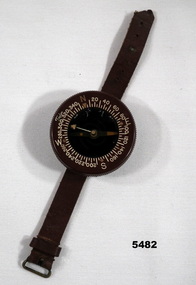 Bendigo Military Museum
Equipment - COMPASS
... ...navigation equipment...See Catalogue No. 5374P for his service record. flying compass equipment navigation equipment maps Flight Lieutenant Ian A. ...Wrist mounted flying compass worn by Flight Lieutenant Ian A. Lyons. Part of Flight Lieutenant Ian A. 'Joe' Lyons MBE Collection. See Catalogue No. 5374P for his service record.Circular faced brown bakelite flying compass with rotating dial. Degrees and NSEW marked on the dial. The direction needle is suspended in liquid. Brown leather strap with buckle for attaching to wrist.Stamped on the back: 'US ARMY COMPASS, WRIST. LIQUID FILLED, TAYLOR MODEL'.flying compass, equipment, navigation equipment, maps, flight lieutenant ian a. lyons -
Moorabbin Air Museum
Book - Aviation training, Private Pilot Course Navigation and Flight Planning
... ...Navigation equipment...Aviation training Basics of air navigation Navigation equipment Flight planning Navigation techniques Text for private pilot students on navigation & flight planning, circa 1981 Private Pilot Course Navigation and Flight Planning Book Aviation training ...Text for private pilot students on navigation & flight planning, circa 1981non-fictionText for private pilot students on navigation & flight planning, circa 1981basics of air navigation, navigation equipment, flight planning, navigation techniques -
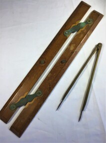 Queenscliffe Maritime Museum
Equipment - A parallel ruler and dividers
... Navigational equipment...Navigational equipment Navigational equipment Parallel Ruler Dividers Navigation chart reading A timber and brass parallel ruler and brass dividers Equipment A parallel ruler and dividers ...Navigational equipmentNavigational equipment A timber and brass parallel ruler and brass dividersparallel ruler, dividers, navigation, chart reading -
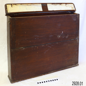 Flagstaff Hill Maritime Museum and Village
Container - Chart Case, Late 19th to early 20th centuries
... navigation...ship equipment...The charts within the case represent the places to which the vessel travelled. flagstaff hill warrnambool shipwrecked coast flagstaff hill maritime museum maritime museum shipwreck coast flagstaff hill maritime village great ocean road map case chart case map box chart box british admiralty charts navigational charts hydrographer charts navigation ship equipment There is a hand written name on the back of the case. ...This case was donated along with the contents of over 60 navigational charts for locations all over the world. The narrow box is built to keep the charts in order and easily accessible on board a vessel. The chart case is a rare example of a container used on board a vessel for the storage and protection of navigational charts. It represents the type of equipment used by the navigator of a seafaring vessel. The charts within the case represent the places to which the vessel travelled.Chart case (or map case), wooden, has hinged opening at top. Front of case folds down and has a hook closure. It contained 65 British Admiralty navigational charts, which are listed and stored separately. (See separate items 2928.2 to 2928.66)There is a hand written name on the back of the case.flagstaff hill, warrnambool, shipwrecked coast, flagstaff hill maritime museum, maritime museum, shipwreck coast, flagstaff hill maritime village, great ocean road, map case, chart case, map box, chart box, british admiralty charts, navigational charts, hydrographer charts, navigation, ship equipment -
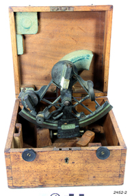 Flagstaff Hill Maritime Museum and Village
Instrument - Sextant, Troughton & Simms, late 19th C. to 1922
... navigation...marine equipment...It was made by London scientific instrument maker Troughton and Simms, which originated in 1826 and continued until 1922. flagstaff hill warrnambool shipwrecked-coast flagstaff-hill flagstaff-hill-maritime-museum maritime-museum shipwreck-coast flagstaff-hill-maritime-village sextant navigational instrument marine navigation marine equipment instrument navigation Troughton and Simms London scientific instrument Sextant and its fitted square wooden box. ...This sextant is very similar to a 1915 Sextant design. A sextant is an astronomical instrument used in measuring angular distances especially the altitudes of sun, moon and starts at sea determining latitude and longitude.This sextant is an example of a 19th-century marine instrument used for finding location at sea. It was made by London scientific instrument maker Troughton and Simms, which originated in 1826 and continued until 1922.Sextant and its fitted square wooden box. The handle of the sextant is carved with a cross-hatched pattern. Made by Troughton and Simms, London.flagstaff hill, warrnambool, shipwrecked-coast, flagstaff-hill, flagstaff-hill-maritime-museum, maritime-museum, shipwreck-coast, flagstaff-hill-maritime-village, sextant, navigational instrument, marine navigation, marine equipment, instrument, navigation, troughton and simms, london, scientific instrument -
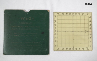 Bendigo Military Museum
Equipment - PROTRACTOR, SQUARE
... navigation...maps...equipment...Used in map reading & air navigation. navigation maps equipment .1) Printed on front: W & G DOUGLAS COMBINED PROTRACTOR AND PARALLEL RULE .2) Handwritten in pencil on back: 410533 DAVEY F.G. .1) Square green coloured card pocket for storing protractor / rule. ...Item re Frederick Gardner DAVEY DFC No 410533. Refer Reg No 3536P for his service details. Used in map reading & air navigation. .1) Square green coloured card pocket for storing protractor / rule. Instructions for using the protractor / rule printed on reverse of pocket. .2) Combined protractor & rule. Square clear plastic with degrees markings around the outer edge. North marked in red. Centre area gridded in one centimeter squares..1) Printed on front: W & G DOUGLAS COMBINED PROTRACTOR AND PARALLEL RULE .2) Handwritten in pencil on back: 410533 DAVEY F.G.navigation, maps, equipment -
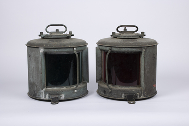 Queenscliffe Maritime Museum
Functional object - Navigation Lights
... Navigation...Safety equipment...Navigation Light Marine Safety Navigation Safety equipment S/N Side Light (red) Elect. ...The Marine Safety Act, Victoria requires that lights must be displayed from sunset to sunrise and in times of restricted visibility during daylight hours. A vessel's lights should indicate: what type of vessel it is, what the vessel is doing, the direction that the vessel is travelling in. E.G. For vessels under 50 m in length, a second masthead light is optional. For vessels under 12 m in length, sidelights may be a combined lantern on fore and aft centreline. Every vessel at sea must show light to indicate type of vessel, directionof travel and speed.Three metal navigational lights; red port, green starboad and clear head light. S/N Side Light (red) Elect. S/N 432 Side Light (Green) Elect. S/N 433 Head Light Elect.navigation light, marine safety, navigation, safety equipment -
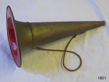 Flagstaff Hill Maritime Museum and Village
Functional object - Megaphone
... equipment...navigation...It represents a similar instrument made in the 19th century and used as a signal or to give instructions, such as on a vessel at sea, to a lifesaving team, or in a marching band. warrnambool Flagstaff Hill Maritime Museum and Village fog horn marine equipment navigation warning signal maritime nautical fireman captain shoulder rope signal safety equipment Megaphone; brass conical shape with an opening at both ends and a join near the wide end. ...This megaphone's conical shape amplifies the sound from the narrow end and would have been used to signal a warning or give instructions. Its design is similar to an earlier brass fog horn used on a marine vessel, as it has a wide brim that allows it to be free-standing, and a shoulder rope makes it portable and frees up the user's hands. The narrow end is shaped into a mouthpiece. The megaphone may have been used at sea foghorn on a vessel, although it has no reeds for the sound, or used by a leader of a band or a fireman or other similar uses. This megaphone's conical shape is based on the centuries-old ram's horn or horn from other animals, used to amplify sound to make it travel a long distance or be heard above other sounds. It represents a similar instrument made in the 19th century and used as a signal or to give instructions, such as on a vessel at sea, to a lifesaving team, or in a marching band. Megaphone; brass conical shape with an opening at both ends and a join near the wide end. The wide opening has a broad brim and is painted red inside. A brass ring is attached near each opening and a narrow rope is attached to each ring. warrnambool, flagstaff hill maritime museum and village, fog horn, marine equipment, navigation, warning signal, maritime, nautical, fireman, captain, shoulder rope, signal, safety equipment -
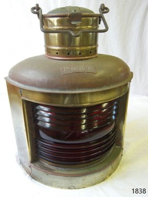 Flagstaff Hill Maritime Museum and Village
Equipment - Navigation Lamp, Port, Bef. 08-02-1984
... navigation lamp...ship's equipment...The metal appears to be electroplated. Equipment Navigation Lamp, Port ...This item appears to be a 20th-century lamp, modelled after an earlier version of a wall-mounted kerosene lamp. Authentic kerosene lamps were typically crafted from copper or brass, renowned for their durability and traditional aesthetic. In contrast, contemporary reproductions are often manufactured using alternative materials and processes, reflecting changes in production methods and cost considerations.The lamp is modelled after marine kerosene navigation lamps that were widely used throughout the 19th and early 20th centuries. These lamps played a significant role in maritime history, providing essential lighting for navigation on vessels during this era. As a representation of this period’s maritime lighting technology, the lamp serves as an example of the type of equipment that would have been commonplace aboard ships of the time. Marine lamp: navigation lamp, portside. Metal Kerosene lamp with two flat sides and a curved, rippled red glass front window. The name "port" is inscribed on a fixed brass plaque. A round chimney is on top of the lid opens with a catch. The fuel tank and wick can be removed through the base. The metal appears to be electroplated.Inscribed on the plaque; "PORT"flagstaff hill, flagstaff hill maritime museum and village, warrnambool, maritime museum, maritime village, great ocean road, shipwreck coast, ship's lamp, kerosene lamp, navigation lamp, ship's equipment, safety equipment, port lamp -
 Bendigo Military Museum
Equipment - PROTRACTOR, SQUARE, C.1939 -45
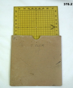
... Navigation...protractor...Military...equipment...Navigation protractor Military equipment marked "T. ISER" .1) 360 deg Protractor labelled as "Direction finder" Used for map navigation planning,yellow plastic. .2) Cardboard sleeve for .1). ...Belonged to Thomas Henry ISER No V24933 and VX102660 2nd AIF. Refer Cat No 383.2 for his service history..1) 360 deg Protractor labelled as "Direction finder" Used for map navigation planning,yellow plastic. .2) Cardboard sleeve for .1).marked "T. ISER"navigation, protractor, military, equipment -
 Flagstaff Hill Maritime Museum and Village
Booklet - Book and World Chart for Emergency Navigation, George Grady Press, The Raft Book, 1943
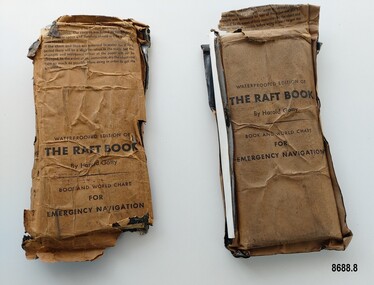
... In 1927 he moved to California and opened a navigation school and also a laboratory repairing navigational equipment. At this time he became very interested in air navigation and was aware of the limitations of existing methods and instruments for aerial navigation. ...In 1927 he moved to California and opened a navigation school and also a laboratory repairing navigational equipment. At this time he became very interested in air navigation and was aware of the limitations of existing methods and instruments for aerial navigation. ...Harold Gatty was born on January 5th, 1903 in Campbell Town, Tasmania. He was a navigator and aviation pioneer. He began his career learning navigation at the age of 14 as a midshipman at the Royal Australian Naval College but withdrew after three years and became an apprenticed ship's officer with the Patrick Steamship Company of Sydney. After W. W. 1 he joined the Australian Merchant Navy where he learned the constellations while standing night watch and became an expert in celestial navigation while serving on many ships sailing between Australia and California. In 1927 he moved to California and opened a navigation school and also a laboratory repairing navigational equipment. At this time he became very interested in air navigation and was aware of the limitations of existing methods and instruments for aerial navigation. He began researching ways of improving aerial navigation. Two early inventions of his were his air sextant and a ground speed and drift indicator which formed the basis of the automatic pilot which later came to be standard equipment on most aircraft. He worked with several record breaking pilots including Ann Morrow Lindbergh (who went on to serve as a navigator for her husband Charles Lindbergh), helped Wiley Post break the world record circumnavigating the Earth, invented a new method of "dead reckoning" that revolutionised the ability to fly safely through cloudy conditions without drifting off course and famously navigated a small plane (whilst trying to cross the Pacific) over 1900 km through fog (with no radio) and using only his dead reckoning techniques, back to their starting point in Japan after they developed fuel problems. In 1932 Gatty received the Distinguished Flying Cross from President Hoover. In 1934 Gatty formed the South Seas Commercial Company with Donald Douglas with the aim to deliver air services to the islands of the South Pacific. The Company was sold to Pan Am but he continued to work for them. In 1935 he went on a sailing expedition investigating several small islands in the South Pacific and was briefly marooned on Baker Island. He was able to use his extensive knowledge of seabird habits to save the crew. He was also very interested in the ability of the Polynesians to navigate using the stars. During the Second World War Gatty was given the honorary rank of Group Captain in the Royal Australian Air Force (RAAF) and worked for the U. S. Army Air Forces (USAAF) in the South Pacific. In 1943 he moved to Washington where he developed a survival book (The Raft Book) specifically for boat crews or air crews flying over the Pacific to help them survive and navigate their life rafts in remote areas of the ocean. The original book was 152 pages long however a condensed version was made which consisted of a 64 page booklet, combined map and star chart and calendar strip enclosed in a waterproof slipcase, to be placed in life rafts for emergency use. The booklet included navigational advice and ideas such as ocean currents, estimation of distance, using a compass, measurement of angles, recognising and steering by the stars, land indications from sea birds, migration of sea birds and insects, sounds from the land, the scent of the land and ocean currents and the colour of the sea etc. After W.W.2 Gatty moved to Fiji and formed Fiji Airways (which later became Air Pacific). Harold Gatty died in August 1957.The two copies of "The Raft Book" are significant as they are a written summary of the many methods of sea navigation (both modern and historical) that existed in the 1940's. They are also a record of Harold Gatty, who played a significant role in the development of modern day aerial navigation using his understanding of different sea navigational techniques.Two rectangular brown packets with waterproof coverings (oiled paper) titled "The Raft Book" by Harold Gatty. Each packet contains a folded 64 page paper booklet with detailed instructions for navigating a small craft in open seas, a folded chart (with a map of the world and oceans, well known constellations, latitude and longitude charts, Greenwich time and a scale for string lengths and Harp scale) and a long folded paper calendar strip.Front of package - "WATERPROOFED EDITION OF/ THE RAFT BOOK / By Harold Gatty / BOOK AND WORLD CHART / FOR / EMERGENCY NAVIGATION / To open envelope tear along above line. If the envelope is used again fold the flap to keep contents dry. 1. This envelope contains a book, chart and tape for emergency navigation. The contents are folded to take up the least possible space and therefore should not be removed until needed. 2. if the chart and tape are immersed in water for a long period, there will be a slight variation in the scale but the strength and resistence to tear of the paper will not be changed. In the event of long immersion, dry the chart and tape as much as possible before using in order to in order to get the greatest accuracy in scale. Front of booklet - THE RAFT BOOK / LORE OF THE SEA AND SKY /By Harold Gatty IMPORTANT FOR YOUR SECURITY/Upon abandoning ship you may have to be your own navigator. Take the following pre/cautions for your own safety:/ Carry a good type of pocket watch / keep it wound and have it running on Greenwich (England) / Time, which you can get from the navigating officer. / Keep track of the date at Greenwich; and on a 24-hour basis, / know whether the time is, say, 6 hours (6 A.M.) showing on / your watch, or 18 hours (6P.M.) Greenwich. / PROECT YOUR WATCH. GET A RUBBER SACK FOR IT (OBTAIN FROM PHARMACIST) AND KEEP IT DRY / KEEP A PENCIL IN YOUR POCKET/ POSITION OF SHIP WHEN ABANDONED PRINTED IN UNITED STATES OF AMERICA GEORGE GRADY PRESS, NEW YORK/COPYRIGHT, 1943, BY HAROLD AND FENNA GATTYflagstaff hill maritime museum and village, shipwreck coast, warrnambool, the raft book, harold gatty, book and world chart for emergency navigation, ww 2, ww ii, navigation, air navigation, aerial navigation, lindbergh, wiley post, dead reckoning, south seas commercial company, u.s. army airforce, usaaf, survival book, life rafts, sea navigation, emergency navigation, fiji airways, harp scale -
 Flagstaff Hill Maritime Museum and Village
Equipment - Ship's Telegraph section, Chadburn & Sons, 1875-1898
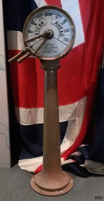
... The ship’s telegraph section was once part of the navigational equipment of the famous paddle steamer, PS Hygeia, and was later installed on Flagstaff Hill’s exhibit, the steamer Rowitta. ...The ship’s telegraph section was once part of the navigational equipment of the famous paddle steamer, PS Hygeia, and was later installed on Flagstaff Hill’s exhibit, the steamer Rowitta. ...The ship’s telegraph section was once part of the navigational equipment of the famous paddle steamer, PS Hygeia, and was later installed on Flagstaff Hill’s exhibit, the steamer Rowitta. This is the Bridge Section of a ship’s telegraph, a Duplex Gong model, made by Chadburn & Son of Liverpool. The gong sounded two signals whenever the navigational commands to change the speed or direction were given by the ship’s pilot. Communication between the ship’s pilot and the engine room in the late 19th to the mid-20th centuries was made with a system called an Engine Order Telegraph (E.O.T.) or ship’s telegraph. The equipment has two parts, the Bridge Section and the Engine Room Section. The Bridge Section was usually mounted onto a pedestal, and the Engine Room Section was attached to a vertical surface. The standard marine commands were printed or stamped around the face of the dial and indicated by a pointer or arrow that was usually moved by a rotating brass section or handle. The ship’s pilot stationed on the Bridge of a vessel sends his Orders for speed and direction to the Engine Room with the E.O.T. He moves the lever or levers, depending on the number of engines the ship has, to change the indicator on the Bridge Section’s dial to point in the new direction and speed of travel. This change causes the Orders to be duplicated on the Engine Room Section’s dial and a bell or bells to signal the change at the same time. The engineer then adjusts the ship’s engines and steering equipment to follow the pilot’s Order. CHADBURN & SON, Liverpool- Chadburn Brothers, William and C.H., were joint inventors and well-established makers of optical and scientific instruments and marine gauges. The firm was granted the Prince Albert Royal Warrant in the late 19th century. In 1870, William Chadburn applied for a patent for his navigational communication device for use on ships. By 1875, Chadburn & Son was producing the brass Engine Order Telegraph in its plant at 71 Lord Street, Liverpool. In 1911, the ship, RMS Titanic, was launched, fitted with Chadburn & Sons E.O.T. The Chadburn Ship Telegraph Company Limited was registered in 1898 to take over Chadburn & Sons. In 1903, a large factory at Bootle, near Liverpool, and its products were being sold overseas. In 1920, electric-powered telegraphs were developed. In 1944, the name changed to Chadburn’s (Liverpool) Limited. In 1968, the company became Chadburn Bloctube Ltd. In 2000, the company, now Bloctube Marine Limited, was still manufacturing ship telegraphs. The P.S. HYGEIA 1890-1932: - This ship’s telegraph was installed on the new paddle steamer, PS Hygeia, one of three iconic pleasure steamers famous for providing regular services in Port Phillip Bay, Victoria, to thousands of passengers between the ports of Queenscliff, Sorrento, Portsea, Dromana, Rosebud, Rye, and Mornington. It joined the Ozone and the Weeroona, all three described as being glamorous, powerful and fast. Its ticket office was on the pier itself. The P.S. Hygeia was built in Yorker, Scotland, in 1890, by Napier, Sharks & Bell. It was registered in Melbourne, Australia, by Hubbart, Parker & Co. in 1891. The steel ship was 92 metres long, able to travel at 22 knots, and licensed to carry over 1600 passengers in luxury, with even a barber shop on board. The regular service between the ports in Port Phillip Bay, Victoria, continued for over 40 years. With the decline in passenger demand, the service wound down. The Hygeia was sold to H.M. Morris in 1931 for demolition and breaking up. Equipment, fittings, and even lifebuoys were sold, with many items purchased by people who had some connection to the Hygeia. On August 25th, 1931, what was left of the vessel departed Port Melbourne and eventually, in June 1932, it was laid to rest at the ships’ graveyard outside Port Phillip Heads. The SS ROWITTA 1909-2015: - The ship’s telegraph was originally installed on the PS Hygeia. It was purchased when the Hygeia was broken up in 1931 and later installed, in 1975, on Flagstaff Hill’s SS Rowitta, an exhibit greatly enjoyed by the public until it was demolished in 2015. The ferry “SS Rowitta” was built in 1909 in Hobart, Tasmania. The timber steam ferry was built using planks of Huon and Karri wood. It was a favourite with sightseeing passengers steaming along Tasmania’s Tamar and Derwent rivers for 30 years. Rowitta was also known as Tarkarri and Sorrento and had worked as a coastal trading vessel between Devonport and Melbourne, and Melbourne, Queenscliff and Sorrento. The vessel had given over 100 years of service and pleasure. This Bridge section of a ship’s Engine Order Telegraph, used with an Engine Room section, represents late-19th-century change and progress in communication and navigation at sea. This type of equipment was still in use in the mid-20th century. It is significant for its association with its maker, Chadburn & Son, of Liverpool, a well-known marine instrument maker whose work was recognised by English Royalty, and whose products were selected to supply similar equipment for use on the RMS Titanic. The ship’s telegraph is also significant for its association with the paddle steamer PS Hygeia, one of three iconic steamers that transported thousands of passengers from port to port within Port Phillip Bay, Victoria, for over 40 years from the 1890s to the 1930s. Queenscliff Borough remembers the Hygeia by naming a road near the pier Hygeia Drive. The Hygeia is registered on the Victorian Heritage Database as a vessel of significance, VHR S329. In 1901, Hygeia had the privilege of carrying their Royal Highnesses, the Duke and Duchess of York, from Mornington to St Kilda Pier, Melbourne, during their Royal visit celebrating the Federation of Australia. The ship’s telegraph is also important for its connection with the Rowitta, a large exhibit on display at Flagstaff Hill Maritime Village, aiding maritime education for over 40 years. It represented the importance of coastal traders to transport, trade and communication along the coast of Victoria, and before the availability of rail and motor vehicles, serving many roles. Bridge section of a Ship’s Telegraph or Engine Order Telegraph (E.O.T.). The round, double-sided, painted glass dial is inside a brass case behind glass. It is fitted onto an outward tapering brass pedestal with a round base. The brass indicator arrows between the handles point simultaneously to both sides of the dial when moved. An oval brass maker’s plate is attached to the top of the case. The dial’s faces have inscriptions that indicate speed and direction, and the front face and plate include the maker’s details. A serial number is stamped on the collar where the dial is fitted to the pedestal. The ship’s telegraph is a Duplex Gong model, made by Chadburn & Son of Liverpool. It was originally part of the navigational fittings on the paddle steamer, PS Hygeia.Dial, maker’s details: “PATENT “DUPLEX GONG” TELEGRAPH / CHADBURN & SON / TELEGRAPH WORKS / PATENTEES & MANUFACTURERS / 11 WATERLOO ROAD / LIVERPOOL” LONDON / 105 FENCHURCH STREET” “NEWCASTLE / 85 QUAY + SIDE” “GLASGOW / 69 ANDERSON QUAY” “PATENT” Dial instructions: “FULL / HALF/ SLOW / FINISHED WITH ENGINES / STOP STAND BY / SLOW / HALF / FULL / ASTERN / AHEAD” Maker’s plate: “CHADBURN / & SON / PATENT / LIVERPOOL” Serial number: “22073”flagstaff hill, warrnambool, maritime village, maritime museum, shipwreck coast, great ocean road, engine order telegraph, e.o.t., navigational instrument, communication device, ship’s telegraph, engine room section, bridge section, rms titanic, chadburn & son, chadburn brothers, william chadburn, chadburn ship telegraph company, chadburns, duplex gong, liverpool, ss rowitta, navigation, marine technology, pilot’s orders, steam power, hobart, tasmania, devonport, tasmanian-built, ferry, steam ferry, steamer, 1909, early 20th century vessel, passenger vessel, tamar trading company, launceston, george town, sorrento, tarkarri, speculant, peter mcgennan, p j mcgennan & co. port phillip ferries pty ltd, melbourne, coastal trader, timber steamer, huon, karri, freighter, supply ship, charter ferry, floating restaurant, prawn boat, lakes entrance, ps hygeia, paddle steamer, pleasure steamer, port phillip bay, queenscliff, portsea, dromana, rosebud, rye, mornington, hubbart parker & co, 1890, 1903, h.m. morris, hygeia -
 Flagstaff Hill Maritime Museum and Village
Book - Textbook, Introduction to Modern Geography
... His younger son William Thomson (1824-1907) became Professor of Natural Philosophy from 1846-1899 at the University of Glasgow, and later the 1st Baron of Kelvin, famous for his designs of nautical instruments such as the navigational compass and sounding equipment used in the transatlantic installation of sea cable. ...His younger son William Thomson (1824-1907) became Professor of Natural Philosophy from 1846-1899 at the University of Glasgow, and later the 1st Baron of Kelvin, famous for his designs of nautical instruments such as the navigational compass and sounding equipment used in the transatlantic installation of sea cable. ...This mid-19th century scientific reference book, Introduction to Modern Geography, explains geography and astronomy using the globe of the world as a teaching aid. The inscription connects this book to the Bobinawarrah Public Library but research to date has found no further details about the library. The rural area was settled in 1859, but in 2016 its population was only 87. It is situated about 21 kilometres south of the City of Wangaratta, in Northeast Victoria. In 2024 the local community received a grant for preservation of its almost 100-year-old Bobinawarrah Memorial Hall which displays an honour board of the Pioneers of Bobinawarrah 1859-1959. The donor of the book lived in Warrnambool. ABOUT THE AUTHOR, James Thomson (1786-1849): - James Thomson was a British Irish mathematician. He became Professor of Mathematics at the University of Glasgow. He wrote many school textbooks and reference books, one of which was Introduction to Modern Geography, first published in Belfast in 1827, and revised and published in over 20 more editions. Thomson tutored two of his several children at home. His older son James Thomson (1822-1892) became an engineer and physicist. His younger son William Thomson (1824-1907) became Professor of Natural Philosophy from 1846-1899 at the University of Glasgow, and later the 1st Baron of Kelvin, famous for his designs of nautical instruments such as the navigational compass and sounding equipment used in the transatlantic installation of sea cable. William was part of the firm that became famous as Kelvin & Hughes Ltd., suppliers of radar and echo sounders to the Ministry of Transport and the Ministry of Defence. The name continued on as Kelvin & Hughes. James Thomson (1786-1849) was a renowned British Irish mathematician and Professor of Mathematics at the University of Glasgow. He was a respected author of many important school books and textbooks that were widely used to provide understanding of arithmetic and geography. Thomson encouraged practical education and held extra classes for young ladies to learn mathematics and geography, which were a novelty at that time. Many of his works were known and used worldwide. This work was published in many editions. It is now considered as culturally significant as a basis for knowledge about our civilisation and has been made publicly available in overseas countries, and republished and reproduced in a readable format, including its diagrams and maps. Book; scientific textbook. The book has a black leather cover. The front cover is blank, but the spine has an embossed gold vertical title within a rectangular border boasting fancy corners. The fly page has a detailed title. The author is James Thomson. It is the Eighteenth edition, published in Simms & McIntyre of London and Belfast in 1845. An inscription connects it to the Bobinawarrah Public Library in Victoria.Spine within a gold border: "THOMSON'S GEOGRAPHY" Fly Page: "AN INTRODUCTION TO MODERN GEOGRAPHY, WITH AN APPENDIX, CONTAINING AN OUTLINE OF ASTRONOMY, AND THE USE OF THE GLOBES. BY JAMES THOMSON, LL.D., PROFESSOR OF MATHEMATICS IN THE UNIVERSITY OF GLASGOW." "Eighteenth Edition" "LONDON: SIMMS AND McINTYRE, ALDINE CHAMBERS, PATERSOSTER ROW; AND DONEGALL -STREET, BELFAST.""1845"flagstaff hill, flagstaff hill maritime museum and village, warrnambool, maritime museum, maritime village, great ocean road, shipwreck coast, introduction to geography, james thomson, reference book, professor thomson's introduction to modern geography, bobinawarrah public library, james thomson mathematician, james thomson engineer, 19th century irish mathematician, irish presbyterian, william thomson 1st baron of kelvin, professor of mathematics, glasgow university, william thomson professor of natural philosophy, introduction to modern geography, outline of astronomy, use of the globes, james thomson ll.d., simms and mcintyre, 1843, scientific book, school book, lord kelvin, baron kelvin of langs, nautical instruments, marine instruments, transatlantic cable, kelvin & hughes, thomson’s geography, astronomy, geography, world globe, cartography, pioneers of bobinawarrah, textbook -
 Flagstaff Hill Maritime Museum and Village
Book, The Old Bus
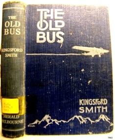
... Together they performed important ‘demonstration’ flights including a flight around Australia in 10 days and 5 hours using very limited navigational equipment. Kingsford Smith immediately started to search for support to do a trans-Pacific flight. ...Together they performed important ‘demonstration’ flights including a flight around Australia in 10 days and 5 hours using very limited navigational equipment. Kingsford Smith immediately started to search for support to do a trans-Pacific flight. ...Sir Charles Edward Kingsford Smith is a famous Australian, well known in civil aviation history for his courageous endeavours in flight. He broken many flight records for long distance and time travelled and he was also a war hero in World War 1. He has been referred to as being “known to millions of Australians as “Smithy” … he was one of Australia’s true twentieth-century legends”. In honour of his place amongst the world’s famous pioneers his image is featured on Australia’s $20 note, Sydney airport is named after him, there is a memorial to Kingsford Smith, Taylor and Ulm at the Anderson Park, also in Sydney and his plane “Southern Cross” is on view at Brisbane Airport. Kingsford Smith wrote ‘The Old Bus’ (1932) and he and Ulm were co-authors of ‘Story of 'Southern Cross' Trans-Pacific Flight’ (1928). His also wrote a book about his own life ‘My Flying Life’ which was published after his death in 1937. and the story of his life was filmed in Australia in 1946. A BRIEF HISTORY OF SIR CHARLES EDWARD KINGSFORD SMITH (1897 – 1935) … Kingsford Smith was born 9th February 1897 in Brisbane, Queensland, Australia. His parents were William Charles Smith and Catherine Mary, nee Kingsford. His mother’s maiden name of “Kingsford” was added to the family name when they spent time in Canada from around 1903 to 1907, after which they returned to Sydney, Australia. In 1915 Kingsford Smith enlisted in Australian Imperial Force. He served in 4th Signal Troop, 2nd Division Signal Company at Gallipoli Peninsular as a ‘sapper’ or combat engineer and later in Egypt and in France as a dispatch rider. In 1916 Kingsford Smith was transferred to the Australian Flying Corps as a sergeant. He was discharged after training in England and commissioned as a second lieutenant in the Royal Flying Corps. He was appointed fling officer and soon joined the 23rd Squadron in France. He brought down four machines in his first month there and also did invaluable work attacking enemy targets. He was wounded and shot down and later awarded the Military Cross ‘for conspicuous gallantry and devotion to duty’. He was promoted to lieutenant in 1918 and served as a Flying Instructor with the R.F.C. Kingsford Smith was not allowed to participate in the 1919 England to Australia air race because of assumed lack of navigational experience. He and his pilot friend Cyril Maddocks formed a business and flew joy-flights in both England and America. In America he did some stunt flying with a Flying Circus. Kingsford Smith returned to Australia in 1921 and found employment as a pilot. He soon realised the value of air transport in such a vast country. He formed a partnership with pilot Keith Anderson in 1924 and they purchased two Bristol Tourer biplanes. Their business broadened to include Charles Ulm and became the Interstate Flying services in Sydney. Together they performed important ‘demonstration’ flights including a flight around Australia in 10 days and 5 hours using very limited navigational equipment. Kingsford Smith immediately started to search for support to do a trans-Pacific flight. This support came from the New South Wales government, Sidney Myer and G. Allan Hancock, an American oil magnate. On 31st May 1928 Kingsford Smith, Charles Ulm and two American crewmen, Harry Lyan and Jim Warner, took off from Oakland, California and flew to Brisbane via Hawaii and Suva. This historic flight took 83 hours and 38 minutes. Their Fokker plane had three engines and was named the “Southern Cross”. This amazing achievement resulted in huge financial subscriptions. Kingsford Smith was awarded the Air Force Cross and appointed as honorary squadron leader, Royal Australian Air Force. Kingsford Smith flew his Southern Cross plane from Point Cook in Victoria to Perth nonstop. Then in September – October 1928, with Charles Ulm and an Australian crew, he piloted the Southern Cross from Sidney to Christchurch New Zealand. This flight showed that was possible for regular passenger and mail services across the Tasman Sea. Kingsford Smith flew his plane to England to an order for four aircraft, planning to use them for an inter-capital air service in Australia. Sadly on 1st April 1929 he was forced to land, having lost radio contact with the ground and having run into bad weather over north – west Australia. Keith Anderson and Robert Hitchcock both perished before the search party reached them. Once official enquiries were completed the flight to England continued in June and was completed in record time of 12 days and 18 hours. In January 1930 Kingsford Smith piloted the “Southern Cloud”, one of the new Avro Ten planes, on the first flight of his airline, the Australian National Airways, from Sydney to Melbourne. The “Southern Cross” was overhauled in Holland by the Fokker Aircraft Co. and in June 1930 Kingsford Smith achieved an east-west crossing of the Atlantic from Ireland to Newfoundland in 31.5 hours. Kingsford Smith returned to England and took delivery of an Avro Avian biplane that he named the “Southern Cross Junior” and flew solo from England to Darwin, Australia. This record breaking flight took less than 10 days. He beat four other planes that had left England before him and he was 5.5 days faster than Hinkler. Sadly Kingsford Smith’s “Southern Cloud” was lost during a flight from Sydney to Melbourne in 1931 with no surviving crew or passengers; in 1958 the wreckage was discovered in the Snowy Mountains. Later that year Kingsford Smith flew his “Southern Cloud” from Australia to Timor, collecting mail from a damaged Imperial Airways plane in Timor. Other flights followed. Kingsford Smith was knighted in 1932 for his services in Aviation. He returned to selling joy flights then established the Kingsford Smith Air Service, a flying training school in Sydney. In 1933 Kingsford Smith flew the amazing record flight in “Miss Southern Cross” – a Percival Gull - from London to Wyndham in Western Australia in just over ten days. The Australian Commonwealth then gave Kingsford Smith a large grant and he was also appointed as aviation consultant to Vacuum Oil Co. Another flying record was made when Kingsford Smith and Sir P.G. Taylor flow “Lady Southern Cross” from Brisbane to San Francisco in order to sell her there; the west-east-trans-Pacific flight made aviation history. They returned to Australia to make an attempt at the trans-Tasman flight but their attempt failed due to engine failure; they managed to get back to Sydney safely, minus most of their cargo. Kingsford Smith had his unsold “Lady Southern Cross” shipped back to England, from where he and J. T. Pethybridge in the “Lady Southern Cross” attempted another record breaking flight from England The Old Bus Author: Charles Kingsford Smith Publisher: Distibuted by Herald Feature Service Date; 1932Label on spine cover with typed text RA 629.1309 KIN flagstaff hill, warrnambool, shipwrecked coast, flagstaff hill maritime museum, maritime museum, shipwreck coast, flagstaff hill maritime village, great ocean road, the old bus, charles kingsford smith -
 Flagstaff Hill Maritime Museum and Village
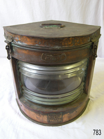
Equipment - Navigation Lamp, Port, Genton & Kessler Ltd, 1900 -1920
... navigation Seahorse Great Britain Genton & Kessler Ltd. Stamped: "Seahorse GB trade mark" "No. 54987" "PORT" Brass lamp marked 'Port', with two small chains and hook locking mechanisms, and a hinged lid. It has a clear ribbed glass front with a red lens filter. The fuel tank and wick burner were removed. Inscriptions marked on the lamp. Manufacturer: Seahorse in Great Britain. Equipment ...Alfred Frederick Samuel Genton was born in Switzerland around 1869 and arrived in England, date unclear. By 1901, the Kelly’s Directory of Birmingham had listed the Genton & Kessler company as manufacturers of all kinds of ship and railway lamps, fog horns and general ship fittings, with their factory listed as the Bingley Works, King Edward Place, Birmingham, UK, which is listed in 1896 as being owned and run by J E & H Player. Then in February 1905 it appears the partnership of Alfred F S Genton & Julius Rudolf Kessler was dissolved and Alfred F S Genton continued to carry on the business on his own. The company continued to be managed by family members until 1961, when it ceased trading.A marine lamp made by a significant maker in Birmingham, England, in the early part of the 20th century. This item is now regarded as a collector's item. Brass lamp marked 'Port', with two small chains and hook locking mechanisms, and a hinged lid. It has a clear ribbed glass front with a red lens filter. The fuel tank and wick burner were removed. Inscriptions marked on the lamp. Manufacturer: Seahorse in Great Britain.Stamped: "Seahorse GB trade mark" "No. 54987" "PORT"flagstaff hill, warrnambool, shipwrecked-coast, flagstaff-hill, flagstaff-hill-maritime-museum, maritime-museum, shipwreck-coast, flagstaff-hill-maritime-village, alfred frederick samuel genton, birmingham, genton & kessler, ship lamp, bingley works, j e & h player, alfred f s genton, navigation lamp, port lamp, bow side lamp, lighting device, navigation, seahorse, great britain, genton & kessler ltd. -
 Flagstaff Hill Maritime Museum and Village
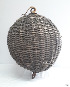
Equipment - Distant Signal, 1897-1931
... navigation Warrnambool flagstaff 1854 1857 1931 1887 1897 Distant Signal Ball, part of a Flagstaff signal set. A round woven cane ball, painted black, with a metal rod passing through the centre. The rod has a loop at each end, then a concave, octagonal metal plate that rests on the outside surface of the ball, serving as a washer. The rod has swivels at each end. Equipment ...This three-dimensional Distant Signal is part of a Flagstaff Signal set of ball, cone and drum shapes. It has been woven and then fabricated with strong metal swivel fittings and loops for suspending from a high point on a flagstaff at a signal station or on a ship’s masthead. The cane signal was constructed to withstand all weather and to be visible from a long distance. The gaps between the woven cane allow air to pass through, minimising possible swaying. Similar sets were made from rope or fabric. Warrnambool's Flagstaff was erected in 1854. Its primary use was to display visual signals that could convey messages between land and sea. It was also used to notify the local population of the approach of ships. One of the popular signalling codes in use in the early-to-mid 1800s was the Marryat’s Code but there were others in use as well; there was no one standard code. In 1857 the International Marine Conference adopted an International Code of Signals as a standard communications system for all vessels that could be understood in many different languages. The Normanby Advertiser reported on June 5th 1857 a query from the Post Master General as to whether the request of the Chief Harbour Master would be carried out, in that Warrnambool would receive a new flagstaff and a set of Marryatt’s signal flags. The Table of Codes was published, showing how to use combinations of these flags to send messages. The Code was revised in 1887 to cover situations where distance, light, wind and weather conditions affected the visibility of the flags and prevented clear communication. The first report of the International Code of Signals Committee of 1897 warned signalmen not to rely on ordinary semaphore flags and introduced a Distant Signal Code using either particular semaphore flags or the three-dimensional shapes of a ball, cone and drum that aligned with the semaphore flag shapes of a circle, pennant and square. International Code of Signals In 1931, after World War I’s experiences in using signal codes, the International Code of Signals conference in Washington revised and published the rules for the conduct of signalling. One of the changes was that “the use of the Distant Signals and of fixed semaphore was abandoned”. It is of interest to know that modern marine law in many countries insists that a set of Day Shapes must be carried onboard vessels of a certain size. These highly visible geometric shapes are used at sea in daylight to communicate messages between vessels. They are used in a similar way to the Distant Signals, in that different combinations of shapes represent different messages. The set of shapes includes a ball, cylinder, cone and diamond. The shapes are hung between the top of the vessel’s foremast and the front of the vessel. They are only coloured black and are about 1.5 metres high. The vertical line of shapes can mean messages such as Boat not under command, Fishing, and Under sail and power.Distant Signals were an important means of marine communication from the late 1880s to the early 1930s, including during World War I. They were an advancement to the International Shipping Codes and safety. The cane signals’ shapes appear to be the same from whatever direction they are viewed, removing confusion about the message they convey. The same shapes continue to be used today for the sets of Day Shapes used as marine navigational signals that are mandatory on certain-sized vessels.Distant Signal Ball, part of a Flagstaff signal set. A round woven cane ball, painted black, with a metal rod passing through the centre. The rod has a loop at each end, then a concave, octagonal metal plate that rests on the outside surface of the ball, serving as a washer. The rod has swivels at each end.flagstaff hill, flagstaff hill maritime museum and village, warrnambool, maritime museum, maritime village, great ocean road, shipwreck coast, distant signal, signal, maritime signal, ball signal, signal shape, flagstaff signal, signal station, masthead signal, communications, marine technology, signals, marine signals, flaghoists, international marine conference, international code of signals, signal codes, marine safety, signal flags, day shape, daymark, day symbol, navigation, warrnambool flagstaff, 1854, 1857 1931, 1887, 1897 -
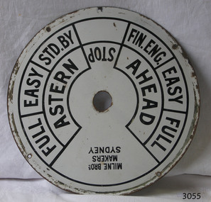 Flagstaff Hill Maritime Museum and Village
Equipment - Ships' Telegraph section, Milne Brothers, Copper and Brass Works, Early-to mid-20th century
... equipment including machinery and gauges for the Railways. The Engine Room section is significant for being part of the communications system on the ship SS Rip, owned by Melbourne's Ports & Harbours department and used to service and maintain the navigation signals of Port Phillip Bay and at Queenscliffe in the mid-20th century. ...This Engine Room section of a ship's telegraph system was part of the equipment of the Ports and Harbour ship the SS Rip. The vessel serviced and maintained the lights and buoys at Port Phillip Bay and Queenscliffe. The SS Rip was possibly the former gunboat "Albert". The ship’s communication system that was used from the late 19th century to early-to-mid-20th-century is called an Engine Order Telegraph (E.O.T.) or ship’s telegraph. The system has two parts, the Bridge Section and the Engine Room Section. The Bridge Section is usually mounted on top of a pedestal, and the Engine Room Section is often attached to a vertical surface. The standard commands printed or stamped onto the dial are the directions of AHEAD and ASTERN, and the speeds of STOP, FULL, EASY, STD. BY. and FIN. ENG. The ship’s pilot on the Bridge of a vessel sends his Orders for speed and direction to the to the Engine Room with the E.O.T. He moves the lever or levers, depending on the number of engines the ship has, to change the indicator on the Bridge Section’s dial to point in the new direction and speed of travel. This change causes the Orders to be duplicated on the Engine Room Section’s dial and a bell to signal the change simultaneously. The engineer then adjusts the ship’s engines and steering equipment to follow the pilot’s Order. The manufacturer, Mulne Bros., was a copper and brass works at 166 Sussex Street Sydney, in December 1892, and previously from 1870 at 128 to 130 Sussex Street. The company made and sold a wide range of equipment including machinery and gauges for the Railways.The Engine Room section is significant for being part of the communications system on the ship SS Rip, owned by Melbourne's Ports & Harbours department and used to service and maintain the navigation signals of Port Phillip Bay and at Queenscliffe in the mid-20th century. The dial is an example of marine equipment made in Australia and used for the safety of Victorian vessels. It is also significant for being made by an early Australian manufacturer, Milne Brothers of Sydney.Engine Room Section of a ship’s telegraph or Engine Order Telegraph (E.O.T.). The round metal dial has inscriptions stamped around the edges. The inscriptions are nautical terms for direction and speed and include the maker’s details. The dial was made by Milne Bros. of Sydney. It was part of the equipment on the "SS Rip" in Victoria.Black paint around dial: "MILNE BROS. / MAKERS / SYDNEY" "FULL EASY STD. BY " "FIN ENG. EASY FULL" ""ASTERN" "STOP" "AHEAD"flagstaff hill, warrnambool, maritime museum, maritime village, great ocean road, shipwreck coast, marine technology, marine communications, engine order telegraph, e.o.t., ship’s telegraph, bridge section, engine room section, ship’s engine telegraph section, marine telegraph, milne bros., milne brothers, sydney, copper and brass works, ports & harbours ship, ss rip, gunboat albert, service ship, maintenance ship -
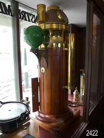 Flagstaff Hill Maritime Museum and Village
Binnacle, Early to mid 20th Century
... (See Links for more information) A significant item of early 20th century marine navigational equipment made by a leading manufacturer in the field from a company that is still producing marine navigational instruments today. ...Mr John Wilson Gillie was born on the 31st of March 1864. On the 31st of July 1880 he was apprenticed for four years to J.J. Wilson and Sons, Nautical Instrument Makers of Sunderland. Following the apprenticeship he spent six months to a year as an ‘improver’ in Glasgow, and then started a new company ‘Wilson and Gillie’ in North Shields. At this time sail had just given way to steam and wooden ships to steel, and the railways were competing with colliers for the carrying of coal from the North East of England to London and the South. In 1858 only seven out of 44 shipyards on the Tyne were using iron, but by 1862 there were ten, employing around 4,000 men. These changes had a significant effect on nautical instrument manufacturers, as the magnetic compass for a wooden sailing vessel was very simple and required little in the way of compensation. For steel vessels much more was required and this was a period of great development, both in the compass bowl and the binnacle in which it was housed. In 1870 Sir William Thomson (later Lord Kelvin) designed his dry card standard compass, which completely replaced all previous designs. Wilson and Gillie started as agents for the Thomson compass, but later J.W. Gillie, using similar principles, redesigned the compass suspension and patented the ‘UNIT’ standard compass. It became popular with local shipowners and shipbuilders. In 1910 the firm of John Lilley and Son (which had been established in London in 1812), found themselves in financial difficulties and were saved with the help of John Wilson Gillie, who established, on the 8th of August 1911, a new firm of John Lilley and Son Limited. John Lilley and Son had been the sole London agents for Sir William Thomson, a very enviable position during this period, when the Thomson compass led the field. Unfortunately, Mr. Lilley had quarreled with the Glasgow company, who withdrew the agency and established their own branch in London (later to become Kelvin White and Hutton). On November 7th 1913, the firm of John Lilley and Son Limited of London amalgamated with Wilson and Gillie of North Shields, and after this date instruments manufactured by the two companies bore the name John Lilley and Son Limited of London and North Shields. During the 1930s many of the London nautical instrument makers were in difficulties, including John Lilley and Son Limited and Reynolds and Son, Dobbie and Clyde Limited, and Mr. J.W. Gillie arranged an amalgamation between these two companies. The new firm became Lilley and Reynolds Limited. In 1943, with estate duties in mind, the North Shields company was reconstituted and took the name of John Lilley and Gillie Limited, although the shareholders, directors and personnel remained unchanged In the early 1970s Lilley and Gillie developed close links with Observator in Rotterdam, who manufactured one of the first fully reliable transmitting magnetic compass systems. The Observator shareholders, Holland America Line, bought the share capital of John Lilley and Gillie Limited., but retained all the personnel and the directors. (See Links for more information)A significant item of early 20th century marine navigational equipment made by a leading manufacturer in the field from a company that is still producing marine navigational instruments today. John Lilleys company began in 1812 growing at a time when the transition of compasses from timber ships, to steel vessels. Compasses at this time required a method of compensation to allow their inclusion in steel vessels without magnetic deviation. This therefore was a period of great development, both in the compass bowl and the binnacle in which it was housed and the Lilley company were leaders in the field. Ships binnacle, wood with brass fittings, consists of 2 brass lamp holders, place for compass, Also has an inclinometer with a scale 40 to 0 to 40, one red and one green iron Kelvin compensation balls, one on each side of binnacle denoting port and starboard, a brass cylinder attached perpendicular at the rear for storing a Flinders Bar, 2 hinged cupboards containing adjustable wooden racks with drilled holes in them to hold iron Heeling error magnets.Textured brass plate attached to front stating "JOHN LILLEY & SON LTD (WILSON & GILLIE), NAUTICAL INSTRUMENT MAKERS, NORTH SHIELDS" . Inclinometer has "JOHN LILLEY & SON LTD (Wilson & Gillie) LONDON & NORTH SHIELDS" engraved. flagstaff hill, warrnambool, shipwrecked-coast, flagstaff-hill, flagstaff-hill-maritime-museum, maritime-museum, shipwreck-coast, flagstaff-hill-maritime-village, binnacle, john lillie & son ltd, compass
