Showing 9 items matching "navigation exploration"
-
 Lakes Entrance Historical Society
Book, Hill, Ernestine, My Love Must Wait - The Loves and Adventures of Matthew Flinders, 1968
... A historical novel, based on Matthew Flinders' life of navigation, exploration and discovery....Lakes Entrance Historical Society 4 Marine Parade Lakes Entrance gippsland Explorers Navigation A historical novel, based on Matthew Flinders' life of navigation, exploration and discovery. My Love Must Wait - The Loves and Adventures of Matthew Flinders. ...A historical novel, based on Matthew Flinders' life of navigation, exploration and discovery.explorers, navigation -
 Phillip Island and District Historical Society Inc.
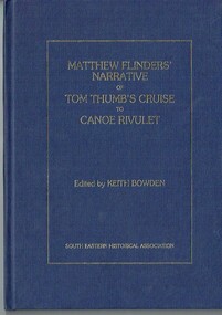
Book - Book, hardcover, Matthew Flinders' narrative of Tom Thumb's cruise to Canoe Rivulet, 1985
... ...navigation exploration...Phillip Island and District Historical Society Inc. phillip-island-and-the-bass-coast Flinders recorded this "cruize" of the Tom Thumb in the form of a Narrative, together with his account of the Schooner Francis's expedition to the Furneaux Islands. matthew flinders tom thumb canoe rivulet keith bowden south eastern historical association pakenham gazette schooner francis furneaux islands navigation exploration xvii, 34 p., [1] leaf of plates : ill., facsims., map, ports. ; 26 cm. ...Flinders recorded this "cruize" of the Tom Thumb in the form of a Narrative, together with his account of the Schooner Francis's expedition to the Furneaux Islands.xvii, 34 p., [1] leaf of plates : ill., facsims., map, ports. ; 26 cm. matthew flinders tom thumb canoe rivulet keith bowden south eastern historical association pakenham gazette schooner francis furneaux islands, navigation exploration -
 Flagstaff Hill Maritime Museum and Village
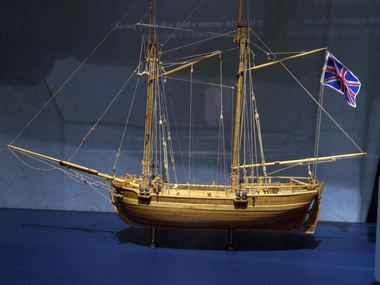
Craft - Ship Model, H.M.S. Lady Nelson, 1988
... This brought the vessel's 25 years of coastal exploration and navigation to a close....This brought the vessel's 25 years of coastal exploration and navigation to a close. The Lady Nelson made was the first British ship to survey of the southern or south-western coast of Australia and traverse the Bass Strait. ...This model of the ship H.M.S. Lady Nelson was researched and built as the vessel Lady Nelson by David Lumsden, a professional ship model builder. His Majesty's Armed Survey Vessel Lady Nelson was commissioned in 1799 to survey the coast of Australia. This vessel was purpose-built before the British Admiralty requested plans for a Schooner for Port Jackson. At the time large parts of the Australian coast were unmapped and Britain had claimed only part of the continent. The British Government were concerned that, in the event of settlers of another European power becoming established in Australia, any future conflict in Europe would lead to a widening of the conflict into the southern hemisphere to the detriment of the trade that Britain sought to develop. Against this background, Lady Nelson was chosen to survey and establish sovereignty over strategic parts of the continent. Lady Nelson left Portsmouth on 18 March 1800 and arrived at Sydney on 16th December 1800 after having been the first vessel to reach the east coast of Australia via the Bass Strait. Before that date, all vessels had sailed around the southern tip of Tasmania to reach their destination. Lady Nelson's survey work commenced shortly after she arrived in Sydney, initially in the Bass Strait area. She was involved in the discovery of Port Phillip, on the coast of Victoria, in establishing settlements on the River Derwent and at Port Dalrymple in Tasmania. She also successfully chartered much of the Victorian coastline and was heavily involved with the exploration of the Queensland coast with Matthew Flinders; investigated the Hunter River; made numerous visits to New Zealand and Norfolk Island and was involved in the founding of numerous settlements. In comparison to most colonial vessels, the Lady Nelson was technically unique she was fitted with sliding keels, or centreboards, and water-tight trunks reaching to the deck. Captain Schank invented these sliding keels that, when raised, reduced her draught to less than six feet. Her life as an exploration vessel ended while accompanying HMS 'Tamar' to Melville Island in 1825, the 'Lady Nelson' was captured and later abandoned by pirates off the island of Babar (Indonesia). This brought the vessel's 25 years of coastal exploration and navigation to a close.The Lady Nelson made was the first British ship to survey of the southern or south-western coast of Australia and traverse the Bass Strait. The vessel holds a special place in Australia's history of exploration as the first to explore and establish settlements in the then-new British colony of Van Diemans Land. The model gives an insight into what life must have been like onboard sailing vessels of the time and Australia's early history of establishment and exploration. This model acts as an important legacy of the full-scale ship which no longer survives. Ship model of the 60 ton British brig HMS Lady Nelson. Timber model of a two-masted brig with rigging but no sails, displaying the British Union Jack flag. The ship is in a glass exhibition display case on metal stand. HMS Lady Nelsonflagstaff hill, warrnambool, shipwrecked coast, flagstaff hill maritime museum, maritime museum, shipwreck coast, flagstaff hill maritime village, great ocean road, by captain john schanck, sliding keels or centreboards, lady nelson, british brig hms lady nelson, david lumsden ship model builder, lieutennant james grant, bass strait discovery, surveying king island and port phillip bay, philip gidley king -
 Mission to Seafarers Victoria
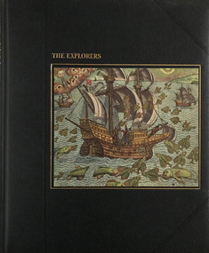
Book - Reference book, Time-Life Books, The Explorers, 1978
... Mission to Seafarers Victoria 717 Flinders Street Docklands melbourne seafarers time life books explorers maps india christopher columbus marco polo caravel navigation the americas spain portugal Illustrations of the time of exploration Undeciphrable signature (Kennedy) and date 13th July 1983 on page 3 Black cover with picture of ship and embossed gilded writings The Explorers Book Reference book Time-Life Books Richard Humble ...Illustrations of the time of explorationBlack cover with picture of ship and embossed gilded writingsnon-fictionIllustrations of the time of explorationseafarers, time life books, explorers, maps, india, christopher columbus, marco polo, caravel, navigation, the americas, spain, portugal -
 Victorian Interpretive Projects Inc.
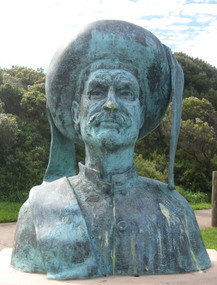
Photograph - Colour, Clare Gervasoni, Sculpture of Portuguese explores at Warrnambool, 02/09/2012
... navigation techniques that made the 15th century voyages of discovery possible. The vision of Prince Henry brought together ship builders, cartographers, instrument makers and mathematicians. Vasco de Gama rounded the southern tip of Africa and sailed across the Indian Ocean to India in 1496. This started a new era of trade and exploration...navigation techniques that made the 15th century voyages of discovery possible. The vision of Prince Henry brought together ship builders, cartographers, instrument makers and mathematicians. Vasco de Gama rounded the southern tip of Africa and sailed across the Indian Ocean to India in 1496. This started a new era of trade and exploration ...The sculptural installation was a gift from the Portuguese government and presented to Warrnambool City Council. The sculptor, Jose Nuncio, completed the work in 1999, and it was inaugurated at Warrnambool in 2001. Prince Henry the Navigator founded a school of navigation in Sagres, Portugal. This led to navigation techniques that made the 15th century voyages of discovery possible. The vision of Prince Henry brought together ship builders, cartographers, instrument makers and mathematicians. Vasco de Gama rounded the southern tip of Africa and sailed across the Indian Ocean to India in 1496. This started a new era of trade and exploration, expanding the boundaries of the known world, and linking the east with west.Six colour photographs of a sculptural installation at Warrnambool. Busts of Vasco De Gama and Prince Henry the Navigator feature in the installation. Images also include two informative plaques containing information on De Gama and the Prince.warrnambool, exploration, navigator, de gama, prince henry the navigator, portugal, portuguese, david atkinson, john pandazopoulos -
 Flagstaff Hill Maritime Museum and Village
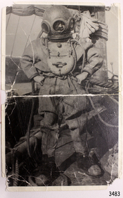
Photograph - Diver, K Tregea, Early 1900s
... These explorations have greatly contributed to our understanding of the region’s history, shedding light on aspects such as shipbuilding techniques, patterns of export and immigration, navigation practices, and other important facets of maritime life. flagstaff hill warrnambool shipwrecked-coast flagstaff-hill flagstaff-hill-maritime-museum maritime-museum shipwreck-coast flagstaff-hill-maritime-village photograph diving gear diving suit deep sea diving deep sea diver diver south west victoria diving photograph T Ward K Tregea Timboon Marine technology Life Saving E. ...This photograph of deep-sea diver Ted Ward (E.G. Ward) on board a vessel. The photograph was produced in the local town of Timboon, and is part of the E. G. Ward Collection. This photograph, depicting a diving suit from the early 1900s, offers a glimpse into the rich history of diving. The details found on the back of the photograph, including the printer’s mark and inscribed names, establish a strong connection to local history and the individuals involved in this era of marine exploration. The southwest coast is renowned for its numerous shipwrecks, many of which have been discovered and explored by dedicated divers. These explorations have greatly contributed to our understanding of the region’s history, shedding light on aspects such as shipbuilding techniques, patterns of export and immigration, navigation practices, and other important facets of maritime life.Black and white photograph, portrait orientation, of a diver dressed in full diving gear standing on board a sailing vessel at sea. Inscriptions on reverse. The photograph is part of the E.G. Ward Collection.Handwritten in black pen "T. WARD" [E. G Ward, also known as Ted Ward] Stamped in black ink "REPRODUCED BY" above rectangular stamp. Text within stamp "[K. TREGEA / CALLOWAY ST / TIMBOON VIC"flagstaff hill, warrnambool, shipwrecked-coast, flagstaff-hill, flagstaff-hill-maritime-museum, maritime-museum, shipwreck-coast, flagstaff-hill-maritime-village, photograph, diving gear, diving suit, deep sea diving, deep sea diver, diver, south west victoria, diving photograph, t ward, k tregea, timboon, marine technology, life saving, e. g. ward, ted ward, e g ward, e.g. ward, edward ward -
 Glenelg Shire Council Cultural Collection
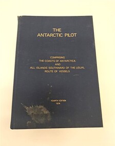
Book, Hydrographer of the Navy, The Antarctic Pilot, 1974
... exploration of Antarctica with Mawson's first expedition in 1911. Research stations were built there is the 1940s and 50s. The Glenelg Shire Council collection tells the story of the maritime history of Portland and the surrounding region. This object is part of a collection belonging to local Portland fisherman Robert Hodgson who also worked for Shore Line Engineering. Naval Navigation ...A reference book detailing the coast and islands of AntarcticaNavy blue hardback book. Gold lettering on the front cover and spine. There is a splash of dirt on the bottom lefthand corner of the front cover. The top of the spine is slightly ripped. It describes the coasts of Antarctica and surrounding islands.non-fictionA reference book detailing the coast and islands of Antarcticanaval, navigation, maritime, nautical, antarctica, portland, glenelg, glenelg shire, vessel, research -
 Sunshine and District Historical Society Incorporated
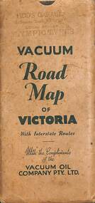
Map - Joseph 'Joe' Wlodarczyk Collection - Vacuum Road Map Of Victoria
... exploration. This map also identified the location of Vacuum Oil Company Dealerships throughout Victoria. These paper-based maps were used before Global Positioning System "GPS" revolutionized navigation. - ...exploration. This map also identified the location of Vacuum Oil Company Dealerships throughout Victoria. These paper-based maps were used before Global Positioning System "GPS" revolutionized navigation. - Map Vacuum Oil Company Pidd's Garage Melbourne Road Newport Joseph 'Joe' Wlodarczyk Envelope - Pidd's Garage Melbourne Road Newport Local Dealer Olympic Tyres Vacuum Road Map of Victoria with Interstate Routes with the compliments of the Vacuum Oil Company Pty Ltd. ...Road travelers relied on foldable paper maps to chart their journeys, especially when venturing beyond familiar territory. Maps helped identify highways, towns, and landmarks, enabling drivers to choose efficient or scenic routes. These maps were indispensable tools for travel, planning, and exploration. This map also identified the location of Vacuum Oil Company Dealerships throughout Victoria. These paper-based maps were used before Global Positioning System "GPS" revolutionized navigation. - Envelope - Pidd's Garage Melbourne Road Newport Local Dealer Olympic Tyres Vacuum Road Map of Victoria with Interstate Routes with the compliments of the Vacuum Oil Company Pty Ltd. Map - Vacuum Road Guide of Victoria Visit Melbourne Centenary 1934-5 Vacuum Oil Company Pty Ltdmap, vacuum oil company, pidd's garage, melbourne road, newport, joseph 'joe' wlodarczyk -
Lakes Entrance Historical Society
Book, Hughes, Thea Stanley, Matthew Flinders, 1985
... Lakes Entrance Historical Society 4 Marine Parade Lakes Entrance gippsland Explorers Navigation Bibliography An account of the life, explorations and achievements of Matthew Flinders. ...An account of the life, explorations and achievements of Matthew Flinders. Written for students. Contains bibliography.explorers, navigation, bibliography